A wide range of spatial data has been analysed to present this overview of the S65 1 Postcode sector. If you would like anything added, please contact us.
The S65 1 postcode sector is within the county of South Yorkshire.
Did you know? According to the 2021 Census, the S65 1 postcode sector is home to a bustling 5,891 residents!
Given that each sector allows for 400 unique postcode combinations. Letters C, I, K, M, O and V are not allowed in the last two letters of a postcode. With 159 postcodes already in use, this leaves 241 units available.
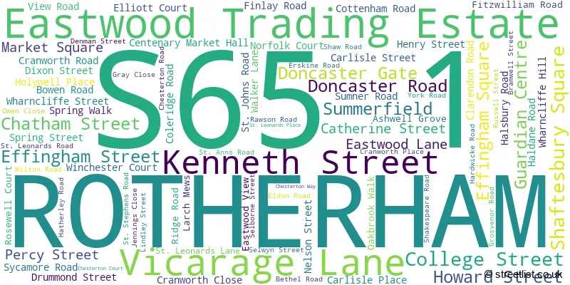
The largest settlements in the S65 1 postal code are ROTHERHAM and Eastwood Trading Estate.
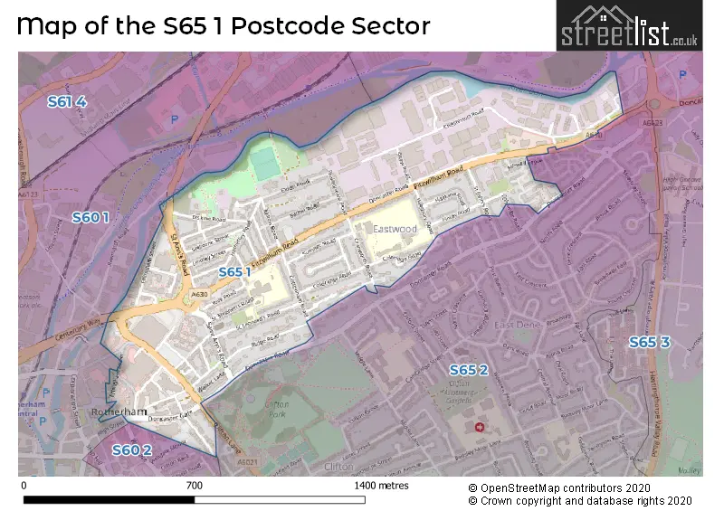
The S65 1 Postcode shares a border with S60 1 (ROTHERHAM, Parkgate), S60 2 (ROTHERHAM), S65 2 (ROTHERHAM) and S65 3 (ROTHERHAM, Dalton).
Map of the S65 1 Postcode Sector
Explore the S65 1 postcode sector by using our interactive map.
The sector is within the post town of ROTHERHAM.
S65 1 is a postcode sector within the S65 postcode district which is within the S Sheffield postcode area.
The Royal Mail delivery office for the S65 1 postal sector is the Rotherham Delivery Office.
The area of the S65 1 postcode sector is 0.54 square miles which is 1.41 square kilometres or 348.53 square acres.
Waterways within the S65 1 postcode sector include the River Don.
Your support helps keep this site running!
If you enjoy using this website, consider buying me a coffee to help cover hosting costs.


| S | 6 | 5 | - | 1 | X | X |
| S | 6 | 5 | Space | 1 | Letter | Letter |
Official List of Streets
ROTHERHAM (74 Streets)
(11 Streets)
Eastwood Trading Estate (6 Streets)
Unofficial Streets or Alternative Spellings
Weather Forecast for S65 1
Weather Forecast for Eastwood (South Yorkshire)
| Time Period | Icon | Description | Temperature | Rain Probability | Wind |
|---|---|---|---|---|---|
| 06:00 to 09:00 | Heavy snow | 0.0°C (feels like -4.0°C) | 98.00% | E 9 mph | |
| 09:00 to 12:00 | Heavy snow | 0.0°C (feels like -3.0°C) | 97.00% | ENE 7 mph | |
| 12:00 to 15:00 | Sleet | 1.0°C (feels like -2.0°C) | 91.00% | NE 7 mph | |
| 15:00 to 18:00 | Heavy rain | 1.0°C (feels like -1.0°C) | 93.00% | NNE 4 mph | |
| 18:00 to 21:00 | Heavy rain | 2.0°C (feels like -1.0°C) | 91.00% | ENE 7 mph | |
| 21:00 to 00:00 | Sleet | 2.0°C (feels like -2.0°C) | 67.00% | NW 9 mph |
| Time Period | Icon | Description | Temperature | Rain Probability | Wind |
|---|---|---|---|---|---|
| 00:00 to 03:00 | Sleet | 2.0°C (feels like -2.0°C) | 90.00% | NW 9 mph | |
| 03:00 to 06:00 | Sleet | 2.0°C (feels like -2.0°C) | 46.00% | NW 11 mph | |
| 06:00 to 09:00 | Light snow | 2.0°C (feels like -2.0°C) | 55.00% | NW 11 mph | |
| 09:00 to 12:00 | Cloudy | 3.0°C (feels like -2.0°C) | 11.00% | WNW 11 mph | |
| 12:00 to 15:00 | Cloudy | 3.0°C (feels like -1.0°C) | 9.00% | WNW 13 mph | |
| 15:00 to 18:00 | Cloudy | 3.0°C (feels like -1.0°C) | 10.00% | WNW 11 mph | |
| 18:00 to 21:00 | Cloudy | 2.0°C (feels like -2.0°C) | 8.00% | W 11 mph | |
| 21:00 to 00:00 | Cloudy | 2.0°C (feels like -2.0°C) | 8.00% | W 9 mph |
| Time Period | Icon | Description | Temperature | Rain Probability | Wind |
|---|---|---|---|---|---|
| 00:00 to 03:00 | Cloudy | 1.0°C (feels like -3.0°C) | 8.00% | W 9 mph | |
| 03:00 to 06:00 | Cloudy | 1.0°C (feels like -3.0°C) | 7.00% | W 9 mph | |
| 06:00 to 09:00 | Cloudy | 1.0°C (feels like -3.0°C) | 7.00% | W 9 mph | |
| 09:00 to 12:00 | Sunny day | 1.0°C (feels like -3.0°C) | 3.00% | W 9 mph | |
| 12:00 to 15:00 | Sunny day | 3.0°C (feels like -1.0°C) | 2.00% | W 11 mph | |
| 15:00 to 18:00 | Sunny day | 3.0°C (feels like -1.0°C) | 1.00% | W 11 mph | |
| 18:00 to 21:00 | Clear night | 2.0°C (feels like -2.0°C) | 1.00% | W 9 mph | |
| 21:00 to 00:00 | Clear night | 1.0°C (feels like -3.0°C) | 1.00% | W 9 mph |
| Time Period | Icon | Description | Temperature | Rain Probability | Wind |
|---|---|---|---|---|---|
| 00:00 to 03:00 | Clear night | 0.0°C (feels like -3.0°C) | 1.00% | W 7 mph | |
| 03:00 to 06:00 | Clear night | 0.0°C (feels like -4.0°C) | 2.00% | W 7 mph | |
| 06:00 to 09:00 | Partly cloudy (night) | -1.0°C (feels like -4.0°C) | 3.00% | W 4 mph | |
| 09:00 to 12:00 | Partly cloudy (day) | -1.0°C (feels like -4.0°C) | 3.00% | WNW 4 mph | |
| 12:00 to 15:00 | Partly cloudy (day) | 1.0°C (feels like -1.0°C) | 4.00% | NW 4 mph | |
| 15:00 to 18:00 | Partly cloudy (day) | 1.0°C (feels like -1.0°C) | 5.00% | NNW 4 mph | |
| 18:00 to 21:00 | Partly cloudy (night) | 0.0°C (feels like -3.0°C) | 6.00% | N 7 mph | |
| 21:00 to 00:00 | Partly cloudy (night) | 0.0°C (feels like -4.0°C) | 8.00% | NNW 7 mph |
Schools and Places of Education Within the S65 1 Postcode Sector
Coleridge Primary
Academy sponsor led
Coleridge Road, Rotherham, South Yorkshire, S65 1LW
Head: Mr Ian Tankard
Ofsted Rating: Outstanding
Inspection: 2022-10-19 (809 days ago)
Website: Visit Coleridge Primary Website
Phone: 01709828988
Number of Pupils: 221
Eastwood Village Primary School
Academy sponsor led
Eldon Road, Rotherham, South Yorkshire, S65 1RD
Head: Ms Kirsty Beresford
Ofsted Rating: Good
Inspection: 2018-07-12 (2369 days ago)
Website: Visit Eastwood Village Primary School Website
Phone: 01709374425
Number of Pupils: 185
RNN Group
Further education
Town Centre Campus, Rotherham, South Yorkshire, S65 1EG
Head: Mr John Connolly
Ofsted Rating: Good
Inspection: 2022-11-25 (772 days ago)
Website: Visit RNN Group Website
Phone: 01709362111
Number of Pupils: 0
ROTHERHAM OPPORTUNITIES COLLEGE
Special post 16 institution
My Place, Rotherham, South Yorkshire, S65 1PH
Head: Dr Perdita Mousley
Ofsted Rating: Requires improvement
Inspection: 2022-12-08 (759 days ago)
Website: Visit ROTHERHAM OPPORTUNITIES COLLEGE Website
Phone: 01709242585
Number of Pupils: 0
St Ann's Primary School
Academy converter
St Leonard's Road, Rotherham, South Yorkshire, S65 1PD
Head: Mr Lee Rowan
Ofsted Rating: Good
Inspection: 2023-09-21 (472 days ago)
Website: Visit St Ann's Primary School Website
Phone: 01709828298
Number of Pupils: 364

House Prices in the S65 1 Postcode Sector
| Type of Property | 2018 Average | 2018 Sales | 2017 Average | 2017 Sales | 2016 Average | 2016 Sales | 2015 Average | 2015 Sales |
|---|---|---|---|---|---|---|---|---|
| Detached | £160,000 | 1 | £114,488 | 4 | £142,500 | 1 | £119,000 | 2 |
| Semi-Detached | £67,250 | 8 | £85,400 | 15 | £72,750 | 6 | £72,500 | 4 |
| Terraced | £41,927 | 31 | £40,386 | 38 | £43,625 | 28 | £36,628 | 41 |
| Flats | £39,950 | 1 | £39,000 | 4 | £51,331 | 56 | £54,792 | 12 |
Important Postcodes S65 1 in the Postcode Sector
S65 1AL is the postcode for The Plough, 39 Effingham Street
S65 1BL is the postcode for Rotherham Leisure Complex, Effingham Street
S65 1DA is the postcode for Rotherham Health Village, Doncaster Gate Hospital
S65 1DJ is the postcode for Rotherham Metropolitan Borough Council, Council Offices, Doncaster Gate
S65 1EB is the postcode for Rotherham Civic Theatre, Catherine Street, Rotherham Town Centre, and Rotherham Civic Theatre, Catherine Street
S65 1EG is the postcode for EASTWOOD BUILDING, RNN Group, Rotherham College, Eastwood Building, Rotherham College of Arts & Technology, HE HUB, RNN Group, Rotherham College, and CLIFTON & WENTWORTH BUILDING, RNN Group, Rotherham College
S65 1EL is the postcode for Centenary Market Hall, and Market Director, Centenary Market Hall
S65 1HX is the postcode for Rotherham Metropolitan Borough Council, Norfolk House, Walker Place
S65 1JH is the postcode for Rotherham Metropolitan Borough Council, Walker Place
S65 1JJ is the postcode for Howard Building, Rotherham College of Arts & Technology
S65 1JQ is the postcode for Clifton and Wentworth Building, Rotherham College of Arts & Technology
S65 1LN is the postcode for Clifton Comprehensive School, Cranworth Road, Rotherham Family Assessment Centre, Cranworth Road, and SPORTS HALL, Clifton Comprehensive School, Cranworth Road
S65 1LW is the postcode for Coleridge Primary School, Coleridge Road, and The Place, Coleridge Road
S65 1LZ is the postcode for APPLIANCE WORKSHOPS AND OFFICES, South Yorkshire Fire & Rescue Service, Fire Station, Fitzwilliam Road, South Yorkshire Fire & Rescue Service, Fire Station, Fitzwilliam Road, and STORES BUILDING, South Yorkshire Fire & Rescue Service, Fire Station, Fitzwilliam Road
S65 1NH is the postcode for Springwell Community Centre, Eastwood View
S65 1NN is the postcode for Rookwood, Doncaster Road
S65 1PD is the postcode for MAIN BUILDING, St. Anns Junior & Infant School, St. Leonards Road, and St. Anns Junior & Infant School, St. Leonards Road
S65 1RD is the postcode for Eastwood Community Primary School, Eldon Road, and Netherfield Court, Eldon Road
S65 1SU is the postcode for Rews Ltd, Chesterton Road
S65 1SX is the postcode for Rotherham PCT NHS, Rotherham Equipment & Wheelchair Services (REWS)
S65 1UE is the postcode for Rotherham Metropolitan Borough Council, Civic Building, Walker Place
| The S65 1 Sector is within these Local Authorities |
|
|---|---|
| The S65 1 Sector is within these Counties |
|
| The S65 1 Sector is within these Water Company Areas |
|