A wide range of spatial data has been analysed to present this overview of the S42 5 Postcode sector. If you would like anything added, please contact us.
The S42 5 postcode sector is within the county of Derbyshire.
Did you know? According to the 2021 Census, the S42 5 postcode sector is home to a bustling 13,060 residents!
Given that each sector allows for 400 unique postcode combinations. Letters C, I, K, M, O and V are not allowed in the last two letters of a postcode. With 300 postcodes already in use, this leaves 100 units available.
The largest settlement in the S42 5 postal code is North Wingfield followed by Holmewood, and Grassmoor.
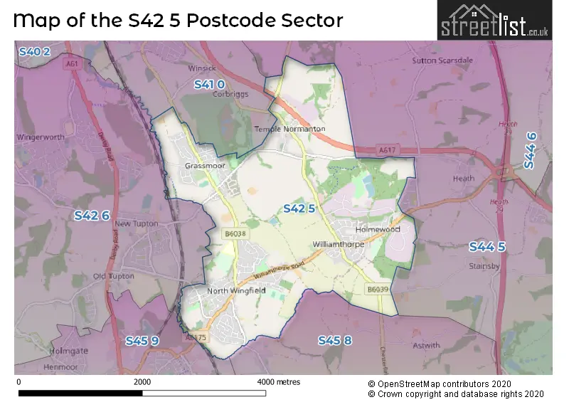
The S42 5 Postcode shares a border with S44 5 (Calow, Duckmanton, Glapwell), S45 8 (Pilsley, Lower Pilsley), S45 9 (Clay Cross, Danesmoor), S41 0 (CHESTERFIELD, Hasland) and S42 6 (Wingerworth, New Tupton, Old Tupton).
Map of the S42 5 Postcode Sector
Explore the S42 5 postcode sector by using our interactive map.
The sector is within the post town of CHESTERFIELD.
S42 5 is a postcode sector within the S42 postcode district which is within the S Sheffield postcode area.
The Royal Mail delivery office for the S42 5 postal sector is the Chesterfield Delivery Office.
The area of the S42 5 postcode sector is 4.54 square miles which is 11.75 square kilometres or 2,904.00 square acres.
Waterways within the S42 5 postcode sector include the River Rother, Muster Brook, Calow Brook.
Your support helps keep this site running!
If you enjoy using this website, consider buying me a coffee to help cover hosting costs.

| S | 4 | 2 | - | 5 | X | X |
| S | 4 | 2 | Space | 5 | Letter | Letter |
Official List of Streets
(44 Streets)
North Wingfield (82 Streets)
Holmewood (65 Streets)
Grassmoor (51 Streets)
Temple Normanton (13 Streets)
Unofficial Streets or Alternative Spellings
Heath
HEATH ROAD SLACK LANECalow
HASSOCKY LANENorth Wingfield
BEELEY CLOSE BROOM CLOSE CAVENDISH COURT DANBURY GROVE DRAYCOTT STREET FIVE PITS ADVENTUROUS CYCLE TRACK FIVE PITS TRAIL GILLS LANE HAGG HILL HALL FARM HENDERSON CLOSE HOLMEWOOD BRIDLEWAY HOLMEWOOD BUSINESS PARK JOHN STREET KNIGHTON COURT MANOR CROFT MOORE CLOSE OUT LANE THE OLD COOP TUPTON WAY WHITE LEAS AVENUE WINGERWORTH STREETCorbriggs
MANSFIELD ROADPilsley
CHESTERFIELD ROADLower Pilsley
PARKHOUSE ROADClay Cross
MARKET STREETWeather Forecast for S42 5
Weather Forecast for Clay Cross
| Time Period | Icon | Description | Temperature | Rain Probability | Wind |
|---|---|---|---|---|---|
| 15:00 to 18:00 | Cloudy | 9.0°C (feels like 6.0°C) | 5.00% | SSW 11 mph | |
| 18:00 to 21:00 | Cloudy | 6.0°C (feels like 3.0°C) | 5.00% | S 9 mph | |
| 21:00 to 00:00 | Cloudy | 5.0°C (feels like 2.0°C) | 4.00% | SSW 11 mph |
| Time Period | Icon | Description | Temperature | Rain Probability | Wind |
|---|---|---|---|---|---|
| 00:00 to 03:00 | Cloudy | 5.0°C (feels like 1.0°C) | 4.00% | SSW 13 mph | |
| 03:00 to 06:00 | Cloudy | 5.0°C (feels like 2.0°C) | 5.00% | SSW 11 mph | |
| 06:00 to 09:00 | Cloudy | 6.0°C (feels like 2.0°C) | 7.00% | SSW 16 mph | |
| 09:00 to 12:00 | Cloudy | 7.0°C (feels like 3.0°C) | 10.00% | SSW 18 mph | |
| 12:00 to 15:00 | Cloudy | 9.0°C (feels like 5.0°C) | 22.00% | SSW 18 mph | |
| 15:00 to 18:00 | Heavy rain | 9.0°C (feels like 6.0°C) | 88.00% | SSW 16 mph | |
| 18:00 to 21:00 | Cloudy | 7.0°C (feels like 4.0°C) | 54.00% | SW 11 mph | |
| 21:00 to 00:00 | Clear night | 6.0°C (feels like 2.0°C) | 2.00% | SW 11 mph |
| Time Period | Icon | Description | Temperature | Rain Probability | Wind |
|---|---|---|---|---|---|
| 00:00 to 03:00 | Clear night | 4.0°C (feels like 1.0°C) | 1.00% | WSW 11 mph | |
| 03:00 to 06:00 | Clear night | 4.0°C (feels like 0.0°C) | 0.00% | WSW 9 mph | |
| 06:00 to 09:00 | Clear night | 3.0°C (feels like 0.0°C) | 1.00% | SW 7 mph | |
| 09:00 to 12:00 | Partly cloudy (day) | 3.0°C (feels like 0.0°C) | 1.00% | WSW 7 mph | |
| 12:00 to 15:00 | Cloudy | 6.0°C (feels like 4.0°C) | 4.00% | W 9 mph | |
| 15:00 to 18:00 | Cloudy | 7.0°C (feels like 4.0°C) | 4.00% | WNW 9 mph | |
| 18:00 to 21:00 | Clear night | 3.0°C (feels like 1.0°C) | 0.00% | WNW 4 mph | |
| 21:00 to 00:00 | Clear night | 1.0°C (feels like -1.0°C) | 0.00% | WNW 4 mph |
| Time Period | Icon | Description | Temperature | Rain Probability | Wind |
|---|---|---|---|---|---|
| 00:00 to 03:00 | Clear night | -1.0°C (feels like -3.0°C) | 0.00% | WNW 2 mph | |
| 03:00 to 06:00 | Clear night | -1.0°C (feels like -3.0°C) | 1.00% | NW 2 mph | |
| 06:00 to 09:00 | Clear night | -1.0°C (feels like -3.0°C) | 1.00% | NNW 2 mph | |
| 09:00 to 12:00 | Sunny day | 1.0°C (feels like 0.0°C) | 2.00% | N 2 mph | |
| 12:00 to 15:00 | Sunny day | 5.0°C (feels like 4.0°C) | 0.00% | E 4 mph | |
| 15:00 to 18:00 | Sunny day | 6.0°C (feels like 4.0°C) | 0.00% | E 7 mph | |
| 18:00 to 21:00 | Clear night | 2.0°C (feels like 0.0°C) | 0.00% | ENE 4 mph | |
| 21:00 to 00:00 | Clear night | 1.0°C (feels like -1.0°C) | 1.00% | ENE 4 mph |
| Time Period | Icon | Description | Temperature | Rain Probability | Wind |
|---|---|---|---|---|---|
| 00:00 to 03:00 | Mist | 1.0°C (feels like -2.0°C) | 13.00% | NE 4 mph | |
| 03:00 to 06:00 | Fog | 1.0°C (feels like -2.0°C) | 14.00% | NE 7 mph | |
| 06:00 to 09:00 | Fog | 1.0°C (feels like -2.0°C) | 15.00% | NE 7 mph | |
| 09:00 to 12:00 | Fog | 1.0°C (feels like -2.0°C) | 15.00% | NE 7 mph | |
| 12:00 to 15:00 | Cloudy | 3.0°C (feels like 0.0°C) | 5.00% | ENE 9 mph | |
| 15:00 to 18:00 | Sunny day | 5.0°C (feels like 2.0°C) | 2.00% | ENE 9 mph | |
| 18:00 to 21:00 | Clear night | 2.0°C (feels like -1.0°C) | 2.00% | NE 7 mph | |
| 21:00 to 00:00 | Cloudy | 1.0°C (feels like -2.0°C) | 5.00% | NE 7 mph |
Schools and Places of Education Within the S42 5 Postcode Sector
Grassmoor Primary School
Community school
North Wingfield Road, Chesterfield, Derbyshire, S42 5EP
Head: Mrs Sharon James
Ofsted Rating: Good
Inspection: 2020-02-05 (1825 days ago)
Website: Visit Grassmoor Primary School Website
Phone: 01246850349
Number of Pupils: 247
Temple Normanton Junior Academy
Academy sponsor led
Elm Street, Chesterfield, Derbyshire, S42 5DW
Head: Mrs Leica Carter
Ofsted Rating: Good
Inspection: 2020-02-05 (1825 days ago)
Website: Visit Temple Normanton Junior Academy Website
Phone: 01246850389
Number of Pupils: 104
House Prices in the S42 5 Postcode Sector
| Type of Property | 2018 Average | 2018 Sales | 2017 Average | 2017 Sales | 2016 Average | 2016 Sales | 2015 Average | 2015 Sales |
|---|---|---|---|---|---|---|---|---|
| Detached | £214,896 | 112 | £195,845 | 96 | £196,223 | 102 | £170,347 | 40 |
| Semi-Detached | £122,451 | 129 | £119,377 | 96 | £115,376 | 103 | £112,088 | 72 |
| Terraced | £96,053 | 56 | £92,924 | 48 | £86,861 | 45 | £82,013 | 54 |
| Flats | £55,000 | 1 | £56,250 | 2 | £79,000 | 2 | £0 | 0 |
Important Postcodes S42 5 in the Postcode Sector
S42 5EP is the postcode for BLOCK 1 (JUNIOR BLOCK), Grassmoor Primary School, North Wingfield Road, and BLOCK 3 (INFANT BLOCK), Grassmoor Primary School, North Wingfield Road
S42 5LE is the postcode for Main Building, North Wingfield Primary & Nursery Academy, 80 Chesterfield Road, North Wingfield Primary School, 80 Chesterfield Road, North Wingfield Primary & Nursery Academy, 80 Chesterfield Road, Tibshelf Community School, North Wingfield Site, and MAIN BUILDING, North Wingfield Primary School, 80 Chesterfield Road
S42 5LH is the postcode for ST LAWRENCE ROAD SURGERY, 17-19 ST LAWRENCE ROAD, NORTH WINGFIELD
S42 5XA is the postcode for Community Centre, Alices View, and Whole Building, Alice's View, North Wingfield
| The S42 5 Sector is within these Local Authorities |
|
|---|---|
| The S42 5 Sector is within these Counties |
|
| The S42 5 Sector is within these Water Company Areas |
|