A wide range of spatial data has been analysed to present this overview of the S40 2 Postcode sector. If you would like anything added, please contact us.
The S40 2 postcode sector is within the county of Derbyshire.
Did you know? According to the 2021 Census, the S40 2 postcode sector is home to a bustling 11,500 residents!
Given that each sector allows for 400 unique postcode combinations. Letters C, I, K, M, O and V are not allowed in the last two letters of a postcode. With 287 postcodes already in use, this leaves 113 units available.
The S40 2 postal code covers the settlement of CHESTERFIELD.
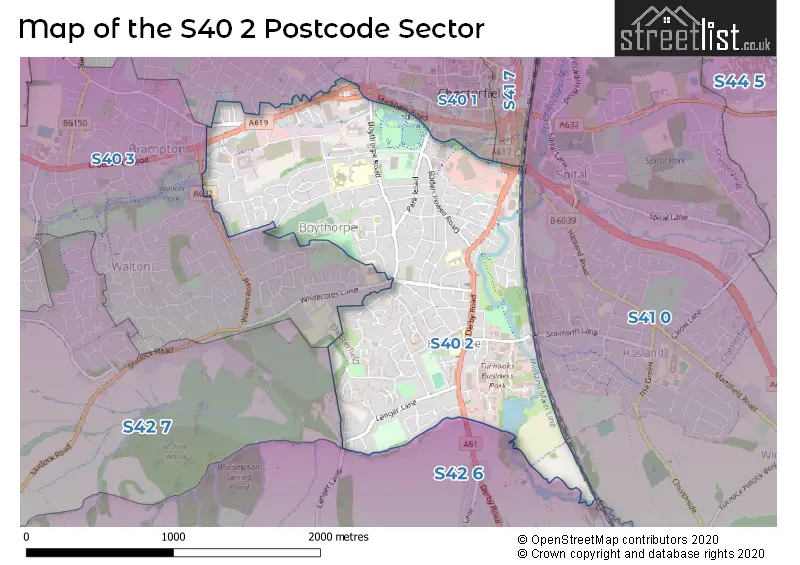
The S40 2 Postcode shares a border with S41 7 (CHESTERFIELD), S40 1 (CHESTERFIELD), S40 3 (CHESTERFIELD), S41 0 (CHESTERFIELD, Hasland), S42 6 (Wingerworth, New Tupton, Old Tupton) and S42 7 (Holymoorside, Walton, Ashgate).
Map of the S40 2 Postcode Sector
Explore the S40 2 postcode sector by using our interactive map.
The sector is within the post town of CHESTERFIELD.
S40 2 is a postcode sector within the S40 postcode district which is within the S Sheffield postcode area.
The Royal Mail delivery office for the S40 2 postal sector is the Chesterfield Delivery Office.
The area of the S40 2 postcode sector is 1.39 square miles which is 3.59 square kilometres or 887.03 square acres.
Waterways within the S40 2 postcode sector include the River Hipper, Holme Brook, River Rother.
Your support helps keep this site running!
If you enjoy using this website, consider buying me a coffee to help cover hosting costs.


| S | 4 | 0 | - | 2 | X | X |
| S | 4 | 0 | Space | 2 | Letter | Letter |
Official List of Streets
CHESTERFIELD (149 Streets)
Unofficial Streets or Alternative Spellings
CHESTERFIELD
BANK STREET BARKER LANE CHESTER STREET MINIMUM TERRACE RIBER TERRACE WALTON DRIVE COURT WALTON ROAD WHITECOTES LANE WINDSOR CLOSE ALMA LEISURE PARK ALMA STREET BRADBURY CLOSE BRICKHOUSE YARD ELM PLACE EMMETFIELD CLOSE FIELD VIEW GOYTSIDE ROAD HIPPER STREET HIPPER VALLEY CYCLEWAY JAW BONES HILL MELLING COURT ROBINCROFT ROTHER VALLEY WASHLANDS SHAWS ROW TOC H YARD WHEATBRIDGE OFFICE PARKHasland
STORFORTH LANEClay Cross
DERBY ROADWingerworth
LANGER LANEWeather Forecast for S40 2
Weather Forecast for Chesterfield
| Time Period | Icon | Description | Temperature | Rain Probability | Wind |
|---|---|---|---|---|---|
| 09:00 to 12:00 | Overcast | 4.0°C (feels like 0.0°C) | 10.00% | SSW 11 mph | |
| 12:00 to 15:00 | Cloudy | 5.0°C (feels like 2.0°C) | 5.00% | SSW 11 mph | |
| 15:00 to 18:00 | Cloudy | 6.0°C (feels like 4.0°C) | 4.00% | SSW 9 mph | |
| 18:00 to 21:00 | Cloudy | 5.0°C (feels like 4.0°C) | 4.00% | S 4 mph | |
| 21:00 to 00:00 | Cloudy | 5.0°C (feels like 4.0°C) | 4.00% | S 4 mph |
| Time Period | Icon | Description | Temperature | Rain Probability | Wind |
|---|---|---|---|---|---|
| 00:00 to 03:00 | Cloudy | 5.0°C (feels like 4.0°C) | 5.00% | SSW 4 mph | |
| 03:00 to 06:00 | Cloudy | 5.0°C (feels like 3.0°C) | 5.00% | SSW 7 mph | |
| 06:00 to 09:00 | Cloudy | 5.0°C (feels like 3.0°C) | 5.00% | SSW 7 mph | |
| 09:00 to 12:00 | Cloudy | 5.0°C (feels like 3.0°C) | 4.00% | SSW 7 mph | |
| 12:00 to 15:00 | Cloudy | 8.0°C (feels like 5.0°C) | 5.00% | SSW 9 mph | |
| 15:00 to 18:00 | Cloudy | 9.0°C (feels like 6.0°C) | 5.00% | SSW 9 mph | |
| 18:00 to 21:00 | Cloudy | 7.0°C (feels like 4.0°C) | 5.00% | SSW 9 mph | |
| 21:00 to 00:00 | Cloudy | 7.0°C (feels like 3.0°C) | 5.00% | SSW 11 mph |
| Time Period | Icon | Description | Temperature | Rain Probability | Wind |
|---|---|---|---|---|---|
| 00:00 to 03:00 | Cloudy | 6.0°C (feels like 3.0°C) | 4.00% | SSW 11 mph | |
| 03:00 to 06:00 | Cloudy | 7.0°C (feels like 3.0°C) | 5.00% | SSW 11 mph | |
| 06:00 to 09:00 | Cloudy | 7.0°C (feels like 3.0°C) | 5.00% | SSW 13 mph | |
| 09:00 to 12:00 | Cloudy | 7.0°C (feels like 4.0°C) | 7.00% | SSW 13 mph | |
| 12:00 to 15:00 | Cloudy | 9.0°C (feels like 6.0°C) | 19.00% | SSW 16 mph | |
| 15:00 to 18:00 | Light rain | 9.0°C (feels like 7.0°C) | 62.00% | SSW 13 mph | |
| 18:00 to 21:00 | Heavy rain | 9.0°C (feels like 6.0°C) | 75.00% | SW 11 mph | |
| 21:00 to 00:00 | Clear night | 7.0°C (feels like 4.0°C) | 5.00% | WSW 11 mph |
| Time Period | Icon | Description | Temperature | Rain Probability | Wind |
|---|---|---|---|---|---|
| 00:00 to 03:00 | Clear night | 6.0°C (feels like 2.0°C) | 1.00% | WSW 11 mph | |
| 03:00 to 06:00 | Clear night | 4.0°C (feels like 1.0°C) | 1.00% | WSW 9 mph | |
| 06:00 to 09:00 | Clear night | 3.0°C (feels like 0.0°C) | 1.00% | WSW 7 mph | |
| 09:00 to 12:00 | Cloudy | 3.0°C (feels like 1.0°C) | 4.00% | WSW 7 mph | |
| 12:00 to 15:00 | Cloudy | 6.0°C (feels like 4.0°C) | 4.00% | W 9 mph | |
| 15:00 to 18:00 | Partly cloudy (day) | 7.0°C (feels like 5.0°C) | 1.00% | WNW 7 mph | |
| 18:00 to 21:00 | Clear night | 4.0°C (feels like 3.0°C) | 1.00% | W 4 mph | |
| 21:00 to 00:00 | Clear night | 2.0°C (feels like 1.0°C) | 1.00% | WNW 4 mph |
| Time Period | Icon | Description | Temperature | Rain Probability | Wind |
|---|---|---|---|---|---|
| 00:00 to 03:00 | Clear night | 1.0°C (feels like -1.0°C) | 1.00% | WNW 4 mph | |
| 03:00 to 06:00 | Clear night | 1.0°C (feels like -1.0°C) | 2.00% | NW 2 mph | |
| 06:00 to 09:00 | Clear night | 0.0°C (feels like -2.0°C) | 2.00% | NNW 2 mph | |
| 09:00 to 12:00 | Sunny day | 1.0°C (feels like -1.0°C) | 3.00% | NNE 4 mph | |
| 12:00 to 15:00 | Sunny day | 5.0°C (feels like 4.0°C) | 1.00% | E 4 mph | |
| 15:00 to 18:00 | Sunny day | 7.0°C (feels like 5.0°C) | 1.00% | E 7 mph | |
| 18:00 to 21:00 | Clear night | 4.0°C (feels like 2.0°C) | 0.00% | ENE 4 mph | |
| 21:00 to 00:00 | Clear night | 2.0°C (feels like 0.0°C) | 0.00% | ENE 4 mph |
Schools and Places of Education Within the S40 2 Postcode Sector
Spire Junior School
Community school
Jawbones Hill, Chesterfield, Derbyshire, S40 2EN
Head: Mrs Charlotte Vernon
Ofsted Rating: Good
Inspection: 2022-05-18 (991 days ago)
Website: Visit Spire Junior School Website
Phone: 01246234546
Number of Pupils: 186
Spire Nursery and Infant School
Community school
Derby Road, Chesterfield, Derbyshire, S40 2EU
Head: Mrs Kelly Hill
Ofsted Rating: Good
Inspection: 2023-07-04 (579 days ago)
Website: Visit Spire Nursery and Infant School Website
Phone: 01246234727
Number of Pupils: 210
House Prices in the S40 2 Postcode Sector
| Type of Property | 2018 Average | 2018 Sales | 2017 Average | 2017 Sales | 2016 Average | 2016 Sales | 2015 Average | 2015 Sales |
|---|---|---|---|---|---|---|---|---|
| Detached | £238,466 | 31 | £226,174 | 33 | £209,514 | 36 | £197,194 | 27 |
| Semi-Detached | £119,615 | 47 | £126,016 | 82 | £118,222 | 69 | £116,864 | 61 |
| Terraced | £109,981 | 55 | £110,781 | 67 | £106,735 | 58 | £101,766 | 49 |
| Flats | £111,474 | 19 | £107,093 | 15 | £105,725 | 12 | £109,989 | 19 |
Important Postcodes S40 2 in the Postcode Sector
S40 2AB is the postcode for @Wheatbridge, 30 Wheatbridge Road, and 30 Wheatbridge Road
S40 2EN is the postcode for Spire Junior School, Jawbones Hill, and Spire Junior School, Jawbones Hill, St Augustines
S40 2EU is the postcode for Spire Infant & Nursery School, Derby Road
S40 2HP is the postcode for THE GRANGE FAMILY CENTRE (LESS PHARMACY & DENTIST PRACTICE), Chesterfield Medical Centre, Stubbing Road
S40 2ND is the postcode for Queens Park Sports Centre, Boythorpe Road, and Chesterfield Borough Council, Queens Park Sports Centre, Boythorpe Road
S40 2NH is the postcode for 575 Field Squadron, Wallis Barracks, Boythorpe Road
S40 2NR is the postcode for William Rhodes Primary School, Hunloke Avenue, and Main Building, William Rhodes Primary School, Hunloke Avenue
S40 2NS is the postcode for BLOCK D, Parkside Community School, Boythorpe Avenue, BLOCK B, Parkside Community School, Boythorpe Avenue, BLOCK B, Parkside Community School, Boythorpe Road, BLOCK A, Parkside Community School, Boythorpe Road, BLOCK C, Parkside Community School, Boythorpe Avenue, CANTEEN, Parkside Community School, Boythorpe Avenue, and BLOCK A, Parkside Community School, Boythorpe Avenue
S40 2QY is the postcode for 1 Brocklehurst Court, Brocklehurst Piece
S40 2TF is the postcode for Birdholme Childrens Centre, Church Street South, and Hunloke Community Centre, Church Street South
S40 2WG is the postcode for Steps 2 Change, Spire Walk
S40 2WH is the postcode for Chesterfield Community Fire Station, Braidwood Way, and Derbyshire Fire & Rescue Service, Chesterfield Community Fire Station, Braidwood Way
| The S40 2 Sector is within these Local Authorities |
|
|---|---|
| The S40 2 Sector is within these Counties |
|
| The S40 2 Sector is within these Water Company Areas |
|