S12 3HY is a postal code used within the United Kingdom for delivering mail.
Postcodes are made up of two parts. The part before the space (S12) is called the outward code. The part after the space (3HY) is called the inward code. The letters C, I, K, M, O and V are not allowed in the inward code. In addition to the inward and outward code, the postcode can be broken up into four parts:
- Postal Area. In our case S which means Sheffield.
- Postal District. In our case S12.
- Postal Sector. In our case S12 3.
- Postcode Unit. The last two letters. In our case HY.
The regional mail center for the post area S is the Yorkshire Distribution Centre, which is located at Silkstone House, Express Way, Wakefield Europort, NORMANTON, WF6 2XX.
The final port of call for any post addressed to the S12 3HY postcode is the local delivery office (DO) which is . Here the post will be sorted ready for delivery.
The properties in the S12 3HY postcode have the street address of Olive Crescent
Did you know? According to the 2021 Census, the S12 3HY postcode is home to a bustling 72 residents!
S12 3HY is within the city of SHEFFIELD.
The S12 3HY postcode area is composed of 100% residential properties, 0% commercial properties, and 0% public properties.
According to our data. Most dwellings in S12 3HY are houses. Of these houses, most are semi-detached.
Most properties in S12 3HY are owned by the occupiers with the rest being privately rented.

Interactive Mapping Showing UPRNs within the boundary of the postcode
Use the search box to search for other postcodes or places.
Your support helps keep this site running!
If you enjoy using this website, consider making a donation to help me cover hosting costs.
Moving to S12 3HY?
I can help you uncover potential pitfalls and provide key questions to ask about your new property. With decades of experience as a Local Land Charges Manager, I offer confidential insights to make your move informed and stress-free.
This service is free, but you may make wish to make an optional donation to support it. Please include the property name and address in your request as well as anything you wish to focus on.
Contact Me| Property Type | Percentage |
|---|---|
| Residential | 100% |
| Commercial | 0% |
| Public | 0% |
Telephone Area Code for S12 3HY
The telephone area code for S12 3HY is 0114 Sheffield.
Map Coordinates
| Latitude | 53.3405393498 |
|---|---|
| Longitude | -1.42397092349 |
Retail and Shopping near S12 3HY
Street
Town
Locality
Distance (Miles)
Central Postcode
Directions on Google Maps
WHITE LANE
SHEFFIELD
0.27
S12 3GF
View on Google Maps
GLEADLESS ROAD
SHEFFIELD
0.46
S12 2LG
View on Google Maps
JAUNTY WAY
SHEFFIELD
0.55
S12 3DZ
View on Google Maps
RIDGEWAY ROAD
SHEFFIELD
0.78
S12 2TA
View on Google Maps
Nearest Town
Distance (Miles)
Direction
Bearing
Dronfield
3.41
SW
219.68
Sheffield
3.44
NNW
327.66
Staveley
5.91
SSE
150.34
Rotherham
6.86
NNE
24.57
Chesterfield
7.21
S
181.72
Dinnington
9.03
ENE
77.53
Bolsover
9.50
SE
144.98
Stocksbridge
12.11
NW
324.46
Wombwell
12.59
N
4.91
Conisbrough
12.66
NE
39.30
Worksop
12.68
E
100.39
Darley Dale
14.12
SSW
208.99
Weather Forecast
Weather Forecast for Gleadless Townend
Time Period Icon Description Temperature Rain Probability Wind 12:00 to 15:00 
Cloudy 4.0°C (feels like 2.0°C) 7.00% SSW 7 mph 15:00 to 18:00 Cloudy 4.0°C (feels like 2.0°C) 7.00% SSW 4 mph 18:00 to 21:00 Cloudy 2.0°C (feels like 0.0°C) 7.00% SSW 4 mph 21:00 to 00:00 Cloudy 1.0°C (feels like -1.0°C) 8.00% SSW 4 mph
Time Period Icon Description Temperature Rain Probability Wind 00:00 to 03:00 
Mist 1.0°C (feels like -1.0°C) 16.00% S 2 mph 03:00 to 06:00 
Fog 1.0°C (feels like -1.0°C) 18.00% S 2 mph 06:00 to 09:00 Fog 0.0°C (feels like -1.0°C) 17.00% S 2 mph 09:00 to 12:00 Fog 0.0°C (feels like -1.0°C) 18.00% ENE 2 mph 12:00 to 15:00 
Overcast 2.0°C (feels like 0.0°C) 11.00% E 2 mph 15:00 to 18:00 Overcast 3.0°C (feels like 1.0°C) 11.00% NE 4 mph 18:00 to 21:00 Overcast 2.0°C (feels like 0.0°C) 12.00% NNE 4 mph 21:00 to 00:00 Fog 2.0°C (feels like 0.0°C) 21.00% N 4 mph
Time Period Icon Description Temperature Rain Probability Wind 00:00 to 03:00 Fog 2.0°C (feels like 0.0°C) 24.00% W 4 mph 03:00 to 06:00 Mist 2.0°C (feels like 0.0°C) 25.00% NW 4 mph 06:00 to 09:00 Fog 2.0°C (feels like -1.0°C) 23.00% WSW 4 mph 09:00 to 12:00 Overcast 2.0°C (feels like -1.0°C) 16.00% W 7 mph 12:00 to 15:00 Overcast 4.0°C (feels like 1.0°C) 15.00% W 7 mph 15:00 to 18:00 Overcast 4.0°C (feels like 2.0°C) 15.00% WSW 7 mph 18:00 to 21:00 Cloudy 3.0°C (feels like 1.0°C) 10.00% WSW 7 mph 21:00 to 00:00 Cloudy 3.0°C (feels like 0.0°C) 9.00% SW 7 mph
What are the Broadband Speeds like?
Download Speeds

Average Mbps 152.100 Median Mbps 78.100 Maximum Mbps 593.000
S12 3HY has an average download speed of 152.1 Megabits per second (Mbps).
318 other postcode units have the same broadband speed.
91% of postcodes (1,077,138) have slower broadband speeds.
9% of postcodes (107,185) have faster broadband speeds.
Upload Speeds
Average Mbps 17.400 Median Mbps 18.900 Maximum Mbps 39.000
S12 3HY has an average upload speed of 17.4 Megabits per second (Mbps).
6,591 other postcode units have the same upload speed.
84% of postcodes (1,000,220) have slower upload speeds.
15% of postcodes (177,830) have faster upload speeds.
Schools within a five minute Drive
England Primary Schools
Birley Primary Academy
Address: Birley Primary Academy, Thornbridge Avenue, Birley, Sheffield, South Yorkshire, S12 3AB
Distance: 0.90 miles
Contact: 01142399002
Birley Community Primary School
Address: Birley Community Primary School, Thornbridge Avenue, Birley, Sheffield, South Yorkshire, S12 3AB
Distance: 0.90 miles
Contact:
Ridgeway Primary School
Address: Ridgeway Primary School, Main Road, Ridgeway, Sheffield, Derbyshire, S12 3XR
Distance: 1.34 miles
Contact: 01142486249
Woodhouse West Primary School
Address: Woodhouse West Primary School, Coisley Hill, Sheffield, South Yorkshire, S13 7BP
Distance: 1.88 miles
Contact:
Stradbroke Primary School
Address: Stradbroke Primary School, Richmond Road, Sheffield, South Yorkshire, S13 8LT
Distance: 1.84 miles
Contact: 01142399320
Intake Primary School
Address: Intake Primary School, Mansfield Road, Intake, Sheffield, South Yorkshire, S12 2AR
Distance: 1.18 miles
Contact: 01142399824
St Theresa's Catholic Primary School
Address: St Theresa's Catholic Primary School, Prince of Wales Road, Sheffield, South Yorkshire, S2 1EY
Distance: 1.67 miles
Contact: 01142397251
Woodlands Primary School
Address: Woodlands Primary School, Norton Avenue, Sheffield, South Yorkshire, S14 1SL
Distance: 0.45 miles
Contact: 01142396464
Gleadless Primary School
Address: Gleadless Primary School, Hollinsend Road, Sheffield, South Yorkshire, S12 2EJ
Distance: 0.79 miles
Contact: 01142399705
Charnock Hall Primary Academy
Address: Charnock Hall Primary Academy, Carter Hall Road, Sheffield, South Yorkshire, S12 3HS
Distance: 0.22 miles
Contact: 01142396083
Charnock Hall Primary School
Address: Charnock Hall Primary School, Carter Hall Road, Sheffield, South Yorkshire, S12 3HS
Distance: 0.22 miles
Contact:
Prince Edward Primary School
Address: Prince Edward Primary School, Queen Mary Road, Sheffield, South Yorkshire, S2 1EE
Distance: 1.43 miles
Contact: 01142281900
Bankwood Community Primary School
Address: Bankwood Community Primary School, Bankwood Close, Sheffield, South Yorkshire, S14 1LW
Distance: 1.43 miles
Contact:
Norfolk Community Primary School
Address: Norfolk Community Primary School, Guildford Avenue, Sheffield, South Yorkshire, S2 2PJ
Distance: 1.90 miles
Contact:
Norton Free Church of England Primary School
Address: Norton Free Church of England Primary School, Matthews Lane, Norton, Sheffield, South Yorkshire, S8 8JS
Distance: 1.40 miles
Contact: 01142745873
England Secondary Schools
The Birley Academy
Address: The Birley Academy, Birley Lane, Sheffield, South Yorkshire, S12 3BP
Distance: 1.11 miles
Contact: 01142392531
Birley Community College
Address: Birley Community College, Birley Lane, Sheffield, South Yorkshire, S12 3BP
Distance: 1.11 miles
Contact:
Sheffield Springs Academy
Address: Sheffield Springs Academy, Hurlfield Road, Sheffield, South Yorkshire, S12 2SF
Distance: 1.21 miles
Contact: 01142392631
Nearest Dentists
BIRLEY MOOR DENTAL CARE
Address: 130 BIRLEY MOOR ROAD, SHEFFIELD, SOUTH YORKSHIRE, S12 4WH
Distance: 1.14 miles
Contact: :
DENTAL SURGERY
Address: 80 RIDGEWAY ROAD, SHEFFIELD, SOUTH YORKSHIRE, S12 2SX
Distance: 1.19 miles
Contact: :
DENTAL SURGERY
Address: 188 MANSFIELD ROAD, SHEFFIELD, SOUTH YORKSHIRE, S12 2AQ
Distance: 1.22 miles
Contact: :
HURLFIELD DENTAL PRACTICE
Address: 49 HURLFIELD ROAD, SHEFFIELD, SOUTH YORKSHIRE, S12 2SD
Distance: 1.26 miles
Contact: :
RIDGEWAY ROAD (DENTAL SURGERY)
Address: 18 RIDGEWAY ROAD, SHEFFIELD, SOUTH YORKSHIRE, S12 2ST
Distance: 1.36 miles
Contact: :
J M SUMMERFIELD AND ASSOCIATES
Address: 2 NEWFIELD GREEN ROAD, SHEFFIELD, SOUTH YORKSHIRE, S2 2BR
Distance: 1.52 miles
Contact: :
Nearest Chemists
CHARNOCK PHARMACY
Address: CHARNOCK HEALTH, PCC, WHITELANE, SHEFFIELD, S12 3GH
Distance: 0.22 miles
Contact: tel: 01142 644455
WELL
Address: WHITE LANE PHARMACY, 202 WHITE LANE, GLEADLESS, SHEFFIELD, SOUTH YORKSHIRE, S12 3GL
Distance: 0.29 miles
Contact: tel: 01142 396174
ARMSTRONG'S PHARMACY
Address: 867-869 GLEADLESS ROAD, SHEFFIELD, SOUTH YORKSHIRE, S12 2LG
Distance: 0.46 miles
Contact: tel: 0114 2654306
JAUNTY HEALTHCARE LIMITED
Address: 37-39 JAUNTY WAY, BASEGREEN, SHEFFIELD, S12 3DZ
Distance: 0.55 miles
Contact: tel: 01142 645180
DAY LEWIS PHARMACY
Address: THE OLD LIBRARY, 153 BLACKSTOCK ROAD, SHEFFIELD, SOUTH YORKSHIRE, S14 1FX
Distance: 0.95 miles
Contact: tel: 01142 648864
LO'S PHARMACY
Address: 52 BIRLEY MOOR ROAD, FRECHEVILLE, SHEFFIELD, S12 4WD
Distance: 1.09 miles
Contact: tel: 01142 396020
Nearest Opticians
WESTFIELD OPTICIANS
Address: 201 WHITE LANE, SHEFFIELD, SOUTH YORKSHIRE, S12 3GG
Distance: 0.30 miles
Contact: :
MARTYN KEMP OPTICIANS (MANOR TOP)
Address: 926-928 CITY ROAD, SHEFFIELD, SOUTH YORKSHIRE, S2 1GQ
Distance: 1.47 miles
Contact: :
NORTON SPECSAVERS LIMITED - SHEFFIELD
Address: UNIT 9A, ST. JAMES RETAIL PARK, BOCHUM PARKWAY, SHEFFIELD, SOUTH YORKSHIRE, S8 8BS
Distance: 2.01 miles
Contact: :
LAWRENCE JENKINSON OPTICIANS - SHEFFIELD
Address: 784 CHESTERFIELD ROAD, WOODSEATS, SHEFFIELD, SOUTH YORKSHIRE, S8 0SF
Distance: 2.25 miles
Contact: :
ALEX GAGE OPTICIANS (CHESTERFIELD ROAD)
Address: 857 CHESTERFIELD ROAD, WOODSEATS, SHEFFIELD, SOUTH YORKSHIRE, S8 0SQ
Distance: 2.26 miles
Contact: :
ROBERT HUGHES EYECARE (WOODHOUSE)
Address: 38 CHAPEL STREET, WOODHOUSE, SHEFFIELD, SOUTH YORKSHIRE, S13 7JN
Distance: 2.48 miles
Contact: :
Nearest GP Surgeries
CHARNOCK HEALTH PRIMARY CARE CENTRE
Address: WHITE LANE, SHEFFIELD, SOUTH YORKSHIRE, S12 3GH
Distance: 0.22 miles
Contact: tel: 0114 2399202
THE MATHEWS PRACTICE WHITE LANE
Address: 203 WHITE LANE, SHEFFIELD, SOUTH YORKSHIRE, S12 3GG
Distance: 0.30 miles
Contact: tel: 0114 2398125
STONECROFT MEDICAL CENTRE
Address: 871 GLEADLESS ROAD, SHEFFIELD, SOUTH YORKSHIRE, S12 2LJ
Distance: 0.35 miles
Contact: tel: 0114 2398575
JAUNTY SPRINGS HEALTH CENTRE
Address: 53 JAUNTY WAY, SHEFFIELD, SOUTH YORKSHIRE, S12 3DZ
Distance: 0.55 miles
Contact: tel: 0114 2647220
BIRLEY HEALTH CENTRE
Address: 120 BIRLEY LANE, SHEFFIELD, SOUTH YORKSHIRE, S12 3BP
Distance: 1.11 miles
Contact: tel: 0114 2358038
BLACKSTOCK ROAD SURGERY
Address: 29 BLACKSTOCK ROAD, SHEFFIELD, SOUTH YORKSHIRE, S14 1AB
Distance: 1.12 miles
Contact: tel: 0114 2585077
Transport Links
Train Stations
Woodhouse
Address: Woodhouse station, Station Road, Woodhouse, South Yorkshire, S13 7RF
Postcode: S13 7RF
Line: Sheffield to Lincoln line
Company: Northern
Time: within ten minutes drive
Distance: 3.17 miles
Darnall
Address: Darnall station, Station Road, Darnall, South Yorkshire, S9 4JU
Postcode: S9 4JU
Line: Sheffield to Lincoln line
Company: Northern
Time: within ten minutes drive
Distance: 2.86 miles
Sheffield
Address: Sheffield station, Sheaf Street, Sheffield, South Yorkshire, S1 2BP
Postcode: S1 2BP
Line: East Midland Main Line|Sheffield to Lincoln line|Hope Valley line|Penistone Line|Wakefield line|Hallam Line|Dearne Valley line
Company: East Midlands Railway
Time: within ten minutes drive
Distance: 3.04 miles
Dronfield
Address: Dronfield station, Dronfield, Dronfield, Derbyshire, S18 8UH
Postcode: S18 8UH
Line: East Midland Main Line
Company: Northern
Time: within ten minutes drive
Distance: 3.28 miles
Dore & Totley
Address: Dore & Totley station, Abbeydale Road South, Dore, South Yorkshire, S17 3LB
Postcode: S17 3LB
Line: East Midland Main Line|Hope Valley line
Company: Northern
Time: within fifteen minutes drive
Distance: 3.88 miles
Meadowhall
Address: Meadowhall station, Meadowhall Road, Meadowhall, South Yorkshire, S9 1JQ
Postcode: S9 1JQ
Line: Penistone Line|Hallam Line|Dearne Valley line
Company: Northern
Time: within fifteen minutes drive
Distance: 5.29 miles
Kiveton Bridge
Address: Kiveton Bridge station, Kiveton Park, Kiveton Bridge, South Yorkshire, S26 8QP
Postcode: S26 8QP
Line: Sheffield to Lincoln line
Company: Northern
Time: within fifteen minutes drive
Distance: 6.47 miles
Rotherham Central
Address: Rotherham Central station, Central Road, Rotherham, South Yorkshire, S60 1QH
Postcode: S60 1QH
Line: Dearne Valley line|Wakefield line
Company: Northern
Time: within fifteen minutes drive
Distance: 6.86 miles
Distances are as the crow flies.
Motorway Junctions
M1 J34Distance: 5.97 milesDriving Time: 10.62 minutesM1 J33Distance: 6.31 milesDriving Time: 10.15 minutesM1 J30Distance: 7.46 milesDriving Time: 13.44 minutesM1 J31Distance: 7.73 milesDriving Time: 11.98 minutes Distances represent the quickest route by car.
Who are my Elected Representatives?
Westminster Constituency Sheffield South East Member or Parliament 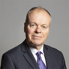
Mr Clive Betts Contact Details Contact Mr Clive Betts Political Party Labour
Where can I find out where the nearest Library is?
Libraries are the responsibility of Sheffield council
Visit the link for more information. Please note that some councils outsource library services to private companies and community groups ran by volunteers.
Libraries and Archives
House Sales
Yearly House Sales
Year High Low Average Sales 2016 £186,500 £180,000 £183,250 2 2020 £155,000 £155,000 £155,000 1 2021 £175,000 £158,000 £166,500 2 2022 £160,000 £230,000 £195,000 2
Contains HM Land Registry data © Crown copyright and database right 2025. This data is licensed under the Open Government Licence v3.0.
Local Postcodes
S12 3JB Arnold AvenueS12 3JA Arnold AvenueS12 3HP Charnock Dale RoadS12 3HQ Charnock Dale RoadS12 3HE Charnock GroveS12 3HF Charnock Hall RoadS12 3HG Charnock Hall RoadS12 3HH Charnock View RoadS12 3HJ Charnock View RoadS12 3HU Farm CloseS12 3JJ Moorland ViewS12 3HZ Parkstone DelphS12 3HX Woodland View
What Popular Supermarkets are near?
Popular Supermarkets near S12 3HY Supermarket Distance Directions Asda, City Road, SHEFFIELD, S12 2AB 2.18 miles Directions to Asda Aldi, St. James Retail Park, Bochum Parkway, SHEFFIELD, S8 8BS 3.23 miles Directions to Aldi Iceland, Chesterfield Road, SHEFFIELD, S8 0SQ 3.63 miles Directions to Iceland Asda, Chesterfield Road, SHEFFIELD, S8 0SQ 3.63 miles Directions to Asda Morrisons, Meadow Head, SHEFFIELD, S8 7UE 3.85 miles Directions to Morrisons
What Popular Restaurants are near?
Burger King Restaurants near S12 3HY Burger King Distance Directions Sheffield Station, Sheaf Street, Sheffield, S1 2BQ 3.05 miles Directions to Sheffield Station, Sheaf Street Sheffield Parkway Retail Park, Sheffield, S2 5AU 3.09 miles Directions to Sheffield Parkway Retail Park Valley Centertainment, Sheffield, S9 2EP 4.16 miles Directions to Valley Centertainment Chesterfield Services, Chesterfield, S41 9BE 5.54 miles Directions to Chesterfield Services
Mcdonald's Restaurants near S12 3HY Mcdonald's Distance Directions McDonald's, Archer Road, SHEFFIELD, S8 0JT 2.67 miles Directions to McDonald's, Archer Road, SHEFFIELD, S8 0JT McDonald's, Handsworth Road, Handsworth, SHEFFIELD, S13 9BS 2.69 miles Directions to McDonald's, Handsworth Road, Handsworth, SHEFFIELD, S13 9BS McDonald's, Farm Road, SHEFFIELD, S2 2TP 2.76 miles Directions to McDonald's, Farm Road, SHEFFIELD, S2 2TP McDonald's, Drake House Way, Waterthorpe, SHEFFIELD, S20 7JJ 2.78 miles Directions to McDonald's, Drake House Way, Waterthorpe, SHEFFIELD, S20 7JJ
KFC Restaurants near S12 3HY Restaurant Distance Directions KFC, City Road, SHEFFIELD, S2 1GJ 1.75 miles Directions to KFC Sheffield - City Road KFC, Chesterfield Road, SHEFFIELD, S8 0SH 2.32 miles Directions to KFC Sheffield - Chesterfield Road KFC, Drake House Way, Waterthorpe, SHEFFIELD, S20 7JJ 2.78 miles Directions to KFC Sheffield - Drake Retail Park KFC, Haymarket, SHEFFIELD, S1 2AW 3.42 miles Directions to KFC Sheffield - Haymarket KFC, Berkeley Precinct, Ecclesall Road, SHEFFIELD, S11 8PN 3.48 miles Directions to KFC Sheffield - Berkeley Centre
| Street | Town | Locality | Distance (Miles) | Central Postcode | Directions on Google Maps |
|---|---|---|---|---|---|
| WHITE LANE | SHEFFIELD | 0.27 | S12 3GF | View on Google Maps | |
| GLEADLESS ROAD | SHEFFIELD | 0.46 | S12 2LG | View on Google Maps | |
| JAUNTY WAY | SHEFFIELD | 0.55 | S12 3DZ | View on Google Maps | |
| RIDGEWAY ROAD | SHEFFIELD | 0.78 | S12 2TA | View on Google Maps |
| Nearest Town | Distance (Miles) | Direction | Bearing |
|---|---|---|---|
| Dronfield | 3.41 | SW | 219.68 |
| Sheffield | 3.44 | NNW | 327.66 |
| Staveley | 5.91 | SSE | 150.34 |
| Rotherham | 6.86 | NNE | 24.57 |
| Chesterfield | 7.21 | S | 181.72 |
| Dinnington | 9.03 | ENE | 77.53 |
| Bolsover | 9.50 | SE | 144.98 |
| Stocksbridge | 12.11 | NW | 324.46 |
| Wombwell | 12.59 | N | 4.91 |
| Conisbrough | 12.66 | NE | 39.30 |
| Worksop | 12.68 | E | 100.39 |
| Darley Dale | 14.12 | SSW | 208.99 |
Weather Forecast
Weather Forecast for Gleadless Townend
| Time Period | Icon | Description | Temperature | Rain Probability | Wind |
|---|---|---|---|---|---|
| 12:00 to 15:00 | Cloudy | 4.0°C (feels like 2.0°C) | 7.00% | SSW 7 mph | |
| 15:00 to 18:00 | Cloudy | 4.0°C (feels like 2.0°C) | 7.00% | SSW 4 mph | |
| 18:00 to 21:00 | Cloudy | 2.0°C (feels like 0.0°C) | 7.00% | SSW 4 mph | |
| 21:00 to 00:00 | Cloudy | 1.0°C (feels like -1.0°C) | 8.00% | SSW 4 mph |
| Time Period | Icon | Description | Temperature | Rain Probability | Wind |
|---|---|---|---|---|---|
| 00:00 to 03:00 | Mist | 1.0°C (feels like -1.0°C) | 16.00% | S 2 mph | |
| 03:00 to 06:00 | Fog | 1.0°C (feels like -1.0°C) | 18.00% | S 2 mph | |
| 06:00 to 09:00 | Fog | 0.0°C (feels like -1.0°C) | 17.00% | S 2 mph | |
| 09:00 to 12:00 | Fog | 0.0°C (feels like -1.0°C) | 18.00% | ENE 2 mph | |
| 12:00 to 15:00 | Overcast | 2.0°C (feels like 0.0°C) | 11.00% | E 2 mph | |
| 15:00 to 18:00 | Overcast | 3.0°C (feels like 1.0°C) | 11.00% | NE 4 mph | |
| 18:00 to 21:00 | Overcast | 2.0°C (feels like 0.0°C) | 12.00% | NNE 4 mph | |
| 21:00 to 00:00 | Fog | 2.0°C (feels like 0.0°C) | 21.00% | N 4 mph |
| Time Period | Icon | Description | Temperature | Rain Probability | Wind |
|---|---|---|---|---|---|
| 00:00 to 03:00 | Fog | 2.0°C (feels like 0.0°C) | 24.00% | W 4 mph | |
| 03:00 to 06:00 | Mist | 2.0°C (feels like 0.0°C) | 25.00% | NW 4 mph | |
| 06:00 to 09:00 | Fog | 2.0°C (feels like -1.0°C) | 23.00% | WSW 4 mph | |
| 09:00 to 12:00 | Overcast | 2.0°C (feels like -1.0°C) | 16.00% | W 7 mph | |
| 12:00 to 15:00 | Overcast | 4.0°C (feels like 1.0°C) | 15.00% | W 7 mph | |
| 15:00 to 18:00 | Overcast | 4.0°C (feels like 2.0°C) | 15.00% | WSW 7 mph | |
| 18:00 to 21:00 | Cloudy | 3.0°C (feels like 1.0°C) | 10.00% | WSW 7 mph | |
| 21:00 to 00:00 | Cloudy | 3.0°C (feels like 0.0°C) | 9.00% | SW 7 mph |
What are the Broadband Speeds like?
Download Speeds
| Average Mbps | 152.100 |
|---|---|
| Median Mbps | 78.100 |
| Maximum Mbps | 593.000 |
S12 3HY has an average download speed of 152.1 Megabits per second (Mbps).
318 other postcode units have the same broadband speed.
91% of postcodes (1,077,138) have slower broadband speeds.
9% of postcodes (107,185) have faster broadband speeds.
Upload Speeds
| Average Mbps | 17.400 |
|---|---|
| Median Mbps | 18.900 |
| Maximum Mbps | 39.000 |
S12 3HY has an average upload speed of 17.4 Megabits per second (Mbps).
6,591 other postcode units have the same upload speed.
84% of postcodes (1,000,220) have slower upload speeds.
15% of postcodes (177,830) have faster upload speeds.
Schools within a five minute Drive
England Primary Schools
Birley Primary Academy
Address: Birley Primary Academy, Thornbridge Avenue, Birley, Sheffield, South Yorkshire, S12 3AB
Distance: 0.90 miles
Contact: 01142399002
Birley Community Primary School
Address: Birley Community Primary School, Thornbridge Avenue, Birley, Sheffield, South Yorkshire, S12 3AB
Distance: 0.90 miles
Contact:
Ridgeway Primary School
Address: Ridgeway Primary School, Main Road, Ridgeway, Sheffield, Derbyshire, S12 3XR
Distance: 1.34 miles
Contact: 01142486249
Woodhouse West Primary School
Address: Woodhouse West Primary School, Coisley Hill, Sheffield, South Yorkshire, S13 7BP
Distance: 1.88 miles
Contact:
Stradbroke Primary School
Address: Stradbroke Primary School, Richmond Road, Sheffield, South Yorkshire, S13 8LT
Distance: 1.84 miles
Contact: 01142399320
Intake Primary School
Address: Intake Primary School, Mansfield Road, Intake, Sheffield, South Yorkshire, S12 2AR
Distance: 1.18 miles
Contact: 01142399824
St Theresa's Catholic Primary School
Address: St Theresa's Catholic Primary School, Prince of Wales Road, Sheffield, South Yorkshire, S2 1EY
Distance: 1.67 miles
Contact: 01142397251
Woodlands Primary School
Address: Woodlands Primary School, Norton Avenue, Sheffield, South Yorkshire, S14 1SL
Distance: 0.45 miles
Contact: 01142396464
Gleadless Primary School
Address: Gleadless Primary School, Hollinsend Road, Sheffield, South Yorkshire, S12 2EJ
Distance: 0.79 miles
Contact: 01142399705
Charnock Hall Primary Academy
Address: Charnock Hall Primary Academy, Carter Hall Road, Sheffield, South Yorkshire, S12 3HS
Distance: 0.22 miles
Contact: 01142396083
Charnock Hall Primary School
Address: Charnock Hall Primary School, Carter Hall Road, Sheffield, South Yorkshire, S12 3HS
Distance: 0.22 miles
Contact:
Prince Edward Primary School
Address: Prince Edward Primary School, Queen Mary Road, Sheffield, South Yorkshire, S2 1EE
Distance: 1.43 miles
Contact: 01142281900
Bankwood Community Primary School
Address: Bankwood Community Primary School, Bankwood Close, Sheffield, South Yorkshire, S14 1LW
Distance: 1.43 miles
Contact:
Norfolk Community Primary School
Address: Norfolk Community Primary School, Guildford Avenue, Sheffield, South Yorkshire, S2 2PJ
Distance: 1.90 miles
Contact:
Norton Free Church of England Primary School
Address: Norton Free Church of England Primary School, Matthews Lane, Norton, Sheffield, South Yorkshire, S8 8JS
Distance: 1.40 miles
Contact: 01142745873
England Secondary Schools
The Birley Academy
Address: The Birley Academy, Birley Lane, Sheffield, South Yorkshire, S12 3BP
Distance: 1.11 miles
Contact: 01142392531
Birley Community College
Address: Birley Community College, Birley Lane, Sheffield, South Yorkshire, S12 3BP
Distance: 1.11 miles
Contact:
Sheffield Springs Academy
Address: Sheffield Springs Academy, Hurlfield Road, Sheffield, South Yorkshire, S12 2SF
Distance: 1.21 miles
Contact: 01142392631
Nearest Dentists
BIRLEY MOOR DENTAL CARE
Address: 130 BIRLEY MOOR ROAD, SHEFFIELD, SOUTH YORKSHIRE, S12 4WH
Distance: 1.14 miles
Contact: :
DENTAL SURGERY
Address: 80 RIDGEWAY ROAD, SHEFFIELD, SOUTH YORKSHIRE, S12 2SX
Distance: 1.19 miles
Contact: :
DENTAL SURGERY
Address: 188 MANSFIELD ROAD, SHEFFIELD, SOUTH YORKSHIRE, S12 2AQ
Distance: 1.22 miles
Contact: :
HURLFIELD DENTAL PRACTICE
Address: 49 HURLFIELD ROAD, SHEFFIELD, SOUTH YORKSHIRE, S12 2SD
Distance: 1.26 miles
Contact: :
RIDGEWAY ROAD (DENTAL SURGERY)
Address: 18 RIDGEWAY ROAD, SHEFFIELD, SOUTH YORKSHIRE, S12 2ST
Distance: 1.36 miles
Contact: :
J M SUMMERFIELD AND ASSOCIATES
Address: 2 NEWFIELD GREEN ROAD, SHEFFIELD, SOUTH YORKSHIRE, S2 2BR
Distance: 1.52 miles
Contact: :
Nearest Chemists
CHARNOCK PHARMACY
Address: CHARNOCK HEALTH, PCC, WHITELANE, SHEFFIELD, S12 3GH
Distance: 0.22 miles
Contact: tel: 01142 644455
WELL
Address: WHITE LANE PHARMACY, 202 WHITE LANE, GLEADLESS, SHEFFIELD, SOUTH YORKSHIRE, S12 3GL
Distance: 0.29 miles
Contact: tel: 01142 396174
ARMSTRONG'S PHARMACY
Address: 867-869 GLEADLESS ROAD, SHEFFIELD, SOUTH YORKSHIRE, S12 2LG
Distance: 0.46 miles
Contact: tel: 0114 2654306
JAUNTY HEALTHCARE LIMITED
Address: 37-39 JAUNTY WAY, BASEGREEN, SHEFFIELD, S12 3DZ
Distance: 0.55 miles
Contact: tel: 01142 645180
DAY LEWIS PHARMACY
Address: THE OLD LIBRARY, 153 BLACKSTOCK ROAD, SHEFFIELD, SOUTH YORKSHIRE, S14 1FX
Distance: 0.95 miles
Contact: tel: 01142 648864
LO'S PHARMACY
Address: 52 BIRLEY MOOR ROAD, FRECHEVILLE, SHEFFIELD, S12 4WD
Distance: 1.09 miles
Contact: tel: 01142 396020
Nearest Opticians
WESTFIELD OPTICIANS
Address: 201 WHITE LANE, SHEFFIELD, SOUTH YORKSHIRE, S12 3GG
Distance: 0.30 miles
Contact: :
MARTYN KEMP OPTICIANS (MANOR TOP)
Address: 926-928 CITY ROAD, SHEFFIELD, SOUTH YORKSHIRE, S2 1GQ
Distance: 1.47 miles
Contact: :
NORTON SPECSAVERS LIMITED - SHEFFIELD
Address: UNIT 9A, ST. JAMES RETAIL PARK, BOCHUM PARKWAY, SHEFFIELD, SOUTH YORKSHIRE, S8 8BS
Distance: 2.01 miles
Contact: :
LAWRENCE JENKINSON OPTICIANS - SHEFFIELD
Address: 784 CHESTERFIELD ROAD, WOODSEATS, SHEFFIELD, SOUTH YORKSHIRE, S8 0SF
Distance: 2.25 miles
Contact: :
ALEX GAGE OPTICIANS (CHESTERFIELD ROAD)
Address: 857 CHESTERFIELD ROAD, WOODSEATS, SHEFFIELD, SOUTH YORKSHIRE, S8 0SQ
Distance: 2.26 miles
Contact: :
ROBERT HUGHES EYECARE (WOODHOUSE)
Address: 38 CHAPEL STREET, WOODHOUSE, SHEFFIELD, SOUTH YORKSHIRE, S13 7JN
Distance: 2.48 miles
Contact: :
Nearest GP Surgeries
CHARNOCK HEALTH PRIMARY CARE CENTRE
Address: WHITE LANE, SHEFFIELD, SOUTH YORKSHIRE, S12 3GH
Distance: 0.22 miles
Contact: tel: 0114 2399202
THE MATHEWS PRACTICE WHITE LANE
Address: 203 WHITE LANE, SHEFFIELD, SOUTH YORKSHIRE, S12 3GG
Distance: 0.30 miles
Contact: tel: 0114 2398125
STONECROFT MEDICAL CENTRE
Address: 871 GLEADLESS ROAD, SHEFFIELD, SOUTH YORKSHIRE, S12 2LJ
Distance: 0.35 miles
Contact: tel: 0114 2398575
JAUNTY SPRINGS HEALTH CENTRE
Address: 53 JAUNTY WAY, SHEFFIELD, SOUTH YORKSHIRE, S12 3DZ
Distance: 0.55 miles
Contact: tel: 0114 2647220
BIRLEY HEALTH CENTRE
Address: 120 BIRLEY LANE, SHEFFIELD, SOUTH YORKSHIRE, S12 3BP
Distance: 1.11 miles
Contact: tel: 0114 2358038
BLACKSTOCK ROAD SURGERY
Address: 29 BLACKSTOCK ROAD, SHEFFIELD, SOUTH YORKSHIRE, S14 1AB
Distance: 1.12 miles
Contact: tel: 0114 2585077
Transport Links
Train Stations
Woodhouse
Address: Woodhouse station, Station Road, Woodhouse, South Yorkshire, S13 7RF
Postcode: S13 7RF
Line: Sheffield to Lincoln line
Company: Northern
Time: within ten minutes drive
Distance: 3.17 miles
Darnall
Address: Darnall station, Station Road, Darnall, South Yorkshire, S9 4JU
Postcode: S9 4JU
Line: Sheffield to Lincoln line
Company: Northern
Time: within ten minutes drive
Distance: 2.86 miles
Sheffield
Address: Sheffield station, Sheaf Street, Sheffield, South Yorkshire, S1 2BP
Postcode: S1 2BP
Line: East Midland Main Line|Sheffield to Lincoln line|Hope Valley line|Penistone Line|Wakefield line|Hallam Line|Dearne Valley line
Company: East Midlands Railway
Time: within ten minutes drive
Distance: 3.04 miles
Dronfield
Address: Dronfield station, Dronfield, Dronfield, Derbyshire, S18 8UH
Postcode: S18 8UH
Line: East Midland Main Line
Company: Northern
Time: within ten minutes drive
Distance: 3.28 miles
Dore & Totley
Address: Dore & Totley station, Abbeydale Road South, Dore, South Yorkshire, S17 3LB
Postcode: S17 3LB
Line: East Midland Main Line|Hope Valley line
Company: Northern
Time: within fifteen minutes drive
Distance: 3.88 miles
Meadowhall
Address: Meadowhall station, Meadowhall Road, Meadowhall, South Yorkshire, S9 1JQ
Postcode: S9 1JQ
Line: Penistone Line|Hallam Line|Dearne Valley line
Company: Northern
Time: within fifteen minutes drive
Distance: 5.29 miles
Kiveton Bridge
Address: Kiveton Bridge station, Kiveton Park, Kiveton Bridge, South Yorkshire, S26 8QP
Postcode: S26 8QP
Line: Sheffield to Lincoln line
Company: Northern
Time: within fifteen minutes drive
Distance: 6.47 miles
Rotherham Central
Address: Rotherham Central station, Central Road, Rotherham, South Yorkshire, S60 1QH
Postcode: S60 1QH
Line: Dearne Valley line|Wakefield line
Company: Northern
Time: within fifteen minutes drive
Distance: 6.86 miles
Distances are as the crow flies.
Motorway Junctions
Distances represent the quickest route by car.
Who are my Elected Representatives?
| Westminster Constituency | Sheffield South East |
|---|---|
| Member or Parliament | |
| Contact Details | Contact Mr Clive Betts |
| Political Party | Labour |
Where can I find out where the nearest Library is?
Libraries are the responsibility of Sheffield council
Visit the link for more information. Please note that some councils outsource library services to private companies and community groups ran by volunteers.
Libraries and ArchivesHouse Sales
| Year | High | Low | Average | Sales |
|---|---|---|---|---|
| 2016 | £186,500 | £180,000 | £183,250 | 2 |
| 2020 | £155,000 | £155,000 | £155,000 | 1 |
| 2021 | £175,000 | £158,000 | £166,500 | 2 |
| 2022 | £160,000 | £230,000 | £195,000 | 2 |
Contains HM Land Registry data © Crown copyright and database right 2025. This data is licensed under the Open Government Licence v3.0.
Local Postcodes
What Popular Supermarkets are near?
| Supermarket | Distance | Directions |
|---|---|---|
| Asda, City Road, SHEFFIELD, S12 2AB | 2.18 miles | Directions to Asda |
| Aldi, St. James Retail Park, Bochum Parkway, SHEFFIELD, S8 8BS | 3.23 miles | Directions to Aldi |
| Iceland, Chesterfield Road, SHEFFIELD, S8 0SQ | 3.63 miles | Directions to Iceland |
| Asda, Chesterfield Road, SHEFFIELD, S8 0SQ | 3.63 miles | Directions to Asda |
| Morrisons, Meadow Head, SHEFFIELD, S8 7UE | 3.85 miles | Directions to Morrisons |
What Popular Restaurants are near?
| Burger King | Distance | Directions |
|---|---|---|
| Sheffield Station, Sheaf Street, Sheffield, S1 2BQ | 3.05 miles | Directions to Sheffield Station, Sheaf Street |
| Sheffield Parkway Retail Park, Sheffield, S2 5AU | 3.09 miles | Directions to Sheffield Parkway Retail Park |
| Valley Centertainment, Sheffield, S9 2EP | 4.16 miles | Directions to Valley Centertainment |
| Chesterfield Services, Chesterfield, S41 9BE | 5.54 miles | Directions to Chesterfield Services |
| Mcdonald's | Distance | Directions |
|---|---|---|
| McDonald's, Archer Road, SHEFFIELD, S8 0JT | 2.67 miles | Directions to McDonald's, Archer Road, SHEFFIELD, S8 0JT |
| McDonald's, Handsworth Road, Handsworth, SHEFFIELD, S13 9BS | 2.69 miles | Directions to McDonald's, Handsworth Road, Handsworth, SHEFFIELD, S13 9BS |
| McDonald's, Farm Road, SHEFFIELD, S2 2TP | 2.76 miles | Directions to McDonald's, Farm Road, SHEFFIELD, S2 2TP |
| McDonald's, Drake House Way, Waterthorpe, SHEFFIELD, S20 7JJ | 2.78 miles | Directions to McDonald's, Drake House Way, Waterthorpe, SHEFFIELD, S20 7JJ |
| Restaurant | Distance | Directions |
|---|---|---|
| KFC, City Road, SHEFFIELD, S2 1GJ | 1.75 miles | Directions to KFC Sheffield - City Road |
| KFC, Chesterfield Road, SHEFFIELD, S8 0SH | 2.32 miles | Directions to KFC Sheffield - Chesterfield Road |
| KFC, Drake House Way, Waterthorpe, SHEFFIELD, S20 7JJ | 2.78 miles | Directions to KFC Sheffield - Drake Retail Park |
| KFC, Haymarket, SHEFFIELD, S1 2AW | 3.42 miles | Directions to KFC Sheffield - Haymarket |
| KFC, Berkeley Precinct, Ecclesall Road, SHEFFIELD, S11 8PN | 3.48 miles | Directions to KFC Sheffield - Berkeley Centre |