A wide range of spatial data has been analysed to present this overview of the RM7 9 Postcode sector. If you would like anything added, please contact us.
The RM7 9 postcode sector is within the county of Greater London.
Did you know? According to the 2021 Census, the RM7 9 postcode sector is home to a bustling 5,563 residents!
Given that each sector allows for 400 unique postcode combinations. Letters C, I, K, M, O and V are not allowed in the last two letters of a postcode. With 108 postcodes already in use, this leaves 292 units available.
The RM7 9 postal code covers the settlement of ROMFORD .
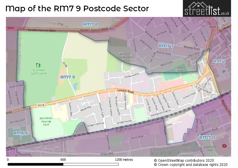
The RM7 9 Postcode shares a border with RM7 7 (ROMFORD ), RM7 8 (ROMFORD , MAWNEYS ), RM1 1 (ROMFORD ), RM6 6 (CHADWELL HEATH , ROMFORD ) and RM7 0 (ROMFORD , RUSH GREEN , MAWNEYS ).
Map of the RM7 9 Postcode Sector
Explore the RM7 9 postcode sector by using our interactive map.
The sector is within the post town of ROMFORD.
RM7 9 is a postcode sector within the RM7 postcode district which is within the RM Romford postcode area.
The Royal Mail delivery office for the RM7 9 postal sector is the Romford Delivery Office.
The area of the RM7 9 postcode sector is 0.68 square miles which is 1.75 square kilometres or 432.73 square acres.
Your support helps keep this site running!
If you enjoy using this website, consider buying me a coffee to help cover hosting costs.


| R | M | 7 | - | 9 | X | X |
| R | M | 7 | Space | 9 | Letter | Letter |
Official List of Streets
ROMFORD (43 Streets)
Unofficial Streets or Alternative Spellings
Weather Forecast for RM7 9
Weather Forecast for Romford
| Time Period | Icon | Description | Temperature | Rain Probability | Wind |
|---|---|---|---|---|---|
| 06:00 to 09:00 | Heavy rain | 3.0°C (feels like -1.0°C) | 87.00% | ESE 9 mph | |
| 09:00 to 12:00 | Heavy rain | 6.0°C (feels like 4.0°C) | 92.00% | S 7 mph | |
| 12:00 to 15:00 | Light rain | 11.0°C (feels like 8.0°C) | 60.00% | SSW 13 mph | |
| 15:00 to 18:00 | Cloudy | 12.0°C (feels like 10.0°C) | 51.00% | SSW 13 mph | |
| 18:00 to 21:00 | Cloudy | 12.0°C (feels like 9.0°C) | 15.00% | SSW 16 mph | |
| 21:00 to 00:00 | Cloudy | 12.0°C (feels like 9.0°C) | 39.00% | SSW 18 mph |
| Time Period | Icon | Description | Temperature | Rain Probability | Wind |
|---|---|---|---|---|---|
| 00:00 to 03:00 | Heavy rain | 12.0°C (feels like 9.0°C) | 87.00% | SSW 18 mph | |
| 03:00 to 06:00 | Heavy rain | 9.0°C (feels like 6.0°C) | 87.00% | W 16 mph | |
| 06:00 to 09:00 | Heavy rain | 7.0°C (feels like 3.0°C) | 84.00% | W 13 mph | |
| 09:00 to 12:00 | Light rain | 7.0°C (feels like 3.0°C) | 51.00% | WSW 13 mph | |
| 12:00 to 15:00 | Light rain | 5.0°C (feels like 1.0°C) | 42.00% | W 13 mph | |
| 15:00 to 18:00 | Cloudy | 5.0°C (feels like 2.0°C) | 9.00% | W 11 mph | |
| 18:00 to 21:00 | Partly cloudy (night) | 5.0°C (feels like 1.0°C) | 7.00% | WSW 9 mph | |
| 21:00 to 00:00 | Partly cloudy (night) | 4.0°C (feels like 1.0°C) | 8.00% | WSW 9 mph |
| Time Period | Icon | Description | Temperature | Rain Probability | Wind |
|---|---|---|---|---|---|
| 00:00 to 03:00 | Partly cloudy (night) | 3.0°C (feels like 0.0°C) | 6.00% | WSW 7 mph | |
| 03:00 to 06:00 | Partly cloudy (night) | 2.0°C (feels like -1.0°C) | 6.00% | WSW 9 mph | |
| 06:00 to 09:00 | Partly cloudy (night) | 2.0°C (feels like -2.0°C) | 4.00% | WSW 9 mph | |
| 09:00 to 12:00 | Sunny day | 2.0°C (feels like -2.0°C) | 5.00% | WSW 9 mph | |
| 12:00 to 15:00 | Sunny day | 4.0°C (feels like 0.0°C) | 4.00% | WSW 11 mph | |
| 15:00 to 18:00 | Sunny day | 5.0°C (feels like 2.0°C) | 3.00% | WSW 9 mph | |
| 18:00 to 21:00 | Clear night | 3.0°C (feels like 0.0°C) | 3.00% | WSW 7 mph | |
| 21:00 to 00:00 | Clear night | 2.0°C (feels like -1.0°C) | 2.00% | WSW 7 mph |
| Time Period | Icon | Description | Temperature | Rain Probability | Wind |
|---|---|---|---|---|---|
| 00:00 to 03:00 | Partly cloudy (night) | 1.0°C (feels like -2.0°C) | 3.00% | WSW 4 mph | |
| 03:00 to 06:00 | Cloudy | 0.0°C (feels like -2.0°C) | 8.00% | SW 4 mph | |
| 06:00 to 09:00 | Cloudy | 0.0°C (feels like -2.0°C) | 13.00% | SE 4 mph | |
| 09:00 to 12:00 | Cloudy | 1.0°C (feels like -2.0°C) | 16.00% | SE 4 mph | |
| 12:00 to 15:00 | Cloudy | 3.0°C (feels like 0.0°C) | 18.00% | N 4 mph | |
| 15:00 to 18:00 | Cloudy | 3.0°C (feels like 0.0°C) | 24.00% | N 7 mph | |
| 18:00 to 21:00 | Cloudy | 3.0°C (feels like -1.0°C) | 21.00% | N 9 mph | |
| 21:00 to 00:00 | Cloudy | 2.0°C (feels like -1.0°C) | 21.00% | N 9 mph |
Schools and Places of Education Within the RM7 9 Postcode Sector
Crowlands Primary School
Community school
London Road, Romford, , RM7 9EJ
Head: Mrs Sarah Clark
Ofsted Rating: Good
Inspection: 2023-10-18 (445 days ago)
Website: Visit Crowlands Primary School Website
Phone: 01708743402
Number of Pupils: 659
St Edward's Church of England Academy
Academy sponsor led
London Road, Romford, Essex, RM7 9NX
Head: Ms Jodie Hassan
Ofsted Rating: Good
Inspection: 2022-05-18 (963 days ago)
Website: Visit St Edward's Church of England Academy Website
Phone: 01708730462
Number of Pupils: 575
House Prices in the RM7 9 Postcode Sector
| Type of Property | 2018 Average | 2018 Sales | 2017 Average | 2017 Sales | 2016 Average | 2016 Sales | 2015 Average | 2015 Sales |
|---|---|---|---|---|---|---|---|---|
| Detached | £375,000 | 1 | £485,000 | 1 | £400,000 | 1 | £0 | 0 |
| Semi-Detached | £353,905 | 29 | £343,848 | 23 | £342,019 | 26 | £310,273 | 22 |
| Terraced | £361,264 | 36 | £350,375 | 32 | £319,565 | 23 | £276,333 | 24 |
| Flats | £231,237 | 38 | £226,220 | 41 | £215,643 | 28 | £179,401 | 35 |
Important Postcodes RM7 9 in the Postcode Sector
RM7 9AA is the postcode for Yew Tree Resource Centre, 20 London Road, Yew Tree Gardens, and London Borough of Havering, Yew Tree Resource Centre, 20 London Road, Yew Tree Gardens
RM7 9DB is the postcode for 175 London Road
RM7 9EJ is the postcode for Crowlands Primary School, London Road, and BLOCK A, Crowlands Primary School, London Road
RM7 9EL is the postcode for 236-238 London Road
RM7 9NH is the postcode for North East London NHS Foundation Trust, 306 London Road
RM7 9NU is the postcode for London Borough of Havering, Westlands Playing Fields Pavilion, London Road
RM7 9NX is the postcode for A BLOCK, St. Edwards C of E Comprehensive School, London Road, A BLOCK, St Edwards C of E Academy, London Road, L BLOCK, St Edwards C of E Academy, London Road, and L BLOCK, St. Edwards C of E Comprehensive School, London Road
| The RM7 9 Sector is within these Local Authorities |
|
|---|---|
| The RM7 9 Sector is within these Counties |
|
| The RM7 9 Sector is within these Water Company Areas |
|