
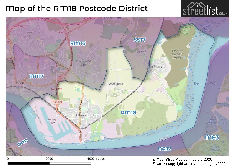
Map of the RM18 Postcode District
Explore the postcode district by using our interactive map.
Circles represent recorded crime; the larger the circle, the higher the crime rates.
Your support helps keep this site running!
If you enjoy using this website, consider buying me a coffee to help cover hosting costs.
Where is the RM18 District?
To give you an idea where the district is located we have created the following table showing nearby towns.
Nearest Towns to RM18
| Town | Distance (miles) | Direction |
|---|---|---|
| Gravesend | 2.17 | SSW |
| Grays | 2.90 | WNW |
| Northfleet | 2.93 | SW |
| Stanford-le-Hope | 4.52 | NNE |
| Swanscombe | 4.80 | WSW |
| Dartford | 6.35 | W |
| Rochester | 7.38 | SE |
| Basildon | 7.40 | NNE |
| Chatham | 8.27 | SE |
| Canvey Island | 9.38 | ENE |
| Snodland | 9.95 | SSE |
| Gillingham | 10.69 | SE |
| Billericay | 10.70 | N |
| Swanley | 10.73 | WSW |
| Brentwood | 11.07 | NNW |
| Wickford | 11.32 | NNE |
| West Malling | 12.18 | S |
| Rayleigh | 12.24 | NE |
| Southend-on-Sea | 14.60 | ENE |
The post town for this district is TILBURY.
Postcode Information for District RM18 (Total Geographical Postcodes: 342)
| Location | Post Town | Sector | Number of Postcodes |
|---|---|---|---|
| TILBURY | TILBURY | RM18 8 | 129 |
| TILBURY | TILBURY | RM18 7 | 124 |
| East Tilbury | TILBURY | RM18 8 | 75 |
| West Tilbury | TILBURY | RM18 8 | 14 |
Retail and Shopping in RM18
Street
Town
Locality
Number of Shops
Central Postcode
View on Google Maps
DOCK ROAD
TILBURY
31
RM18 7BJ
View on Google Maps
CALCUTTA ROAD
TILBURY
22
RM18 7QU
View on Google Maps
MONTREAL ROAD
TILBURY
15
RM18 7QX
View on Google Maps
CIVIC SQUARE
TILBURY
13
RM18 8AD
View on Google Maps
ST CHADS ROAD
TILBURY
12
RM18 8NL
View on Google Maps
PRINCESS MARGARET ROAD
GRAYS
EAST TILBURY
7
RM18 8YP
View on Google Maps
| Street | Town | Locality | Number of Shops | Central Postcode | View on Google Maps |
|---|---|---|---|---|---|
| DOCK ROAD | TILBURY | 31 | RM18 7BJ | View on Google Maps | |
| CALCUTTA ROAD | TILBURY | 22 | RM18 7QU | View on Google Maps | |
| MONTREAL ROAD | TILBURY | 15 | RM18 7QX | View on Google Maps | |
| CIVIC SQUARE | TILBURY | 13 | RM18 8AD | View on Google Maps | |
| ST CHADS ROAD | TILBURY | 12 | RM18 8NL | View on Google Maps | |
| PRINCESS MARGARET ROAD | GRAYS | EAST TILBURY | 7 | RM18 8YP | View on Google Maps |
The primary settlement in the RM18 postcode district is Tilbury, located in the county of Essex in England.
When it comes to local government, postal geography often disregards political borders. However, this district intersects the following councils: the district mostly encompasses the Thurrock (B) area with a total of 338 postal codes.
The largest settlement in the RM18 postal code is TILBURY followed by East Tilbury, and West Tilbury.
The postcode area has a boundary with Tidal Thames and Thames Estuary.
The RM18 Postcode shares a border with RM17 (GRAYS, Badgers Dene), RM16 (GRAYS, CHAFFORD HUNDRED, STIFFORD CLAYS) and SS17 (STANFORD-LE-HOPE, Corringham, Horndon-on-the-Hill).


Dentists in the RM18 District
| # | Name | Address | Type | Contact |
|---|---|---|---|---|
| 1 | Dental Surgery | 154 DOCK ROAD , TILBURY , ESSEX , RM18 7BS | GENERAL DENTAL PRACTICE | |
| 2 | Elite Dental Studio | 13-14 CIVIC SQUARE , TILBURY , ESSEX , RM18 8AD | GENERAL DENTAL PRACTICE |
Doctors in the RM18 District
| # | Name | Address | Type | Contact |
|---|---|---|---|---|
| 1 | Dr M K Ramachandran | , 8 CORONATION AVENUE , EAST TILBURY , GRAYS , ESSEX , RM18 8SJ | BRANCH SURGERY | |
| 2 | Medic House | , TILBURY , ESSEX , RM18 7RJ | GP PRACTICE | |
| 3 | Sai Medical Centre | , TILBURY , ESSEX , RM18 7QA | GP PRACTICE | |
| 4 | The Rigg-milner Medical Centre | , EAST TILBURY , TILBURY , ESSEX , RM18 8SD | GP PRACTICE | |
| 5 | Tilbury Health Centre | , TILBURY , ESSEX , RM18 8EB | GP PRACTICE | |
| 6 | Commonwealth Health Centre | , TILBURY , ESSEX , RM18 7RB | GP PRACTICE | |
| 7 | East Tilbury & Corringham Medical Centre | , EAST TILBURY , TILBURY , RM18 8SW | BRANCH SURGERY |
Chemists in the RM18 District
| # | Name | Address | Type | Contact |
|---|---|---|---|---|
| 1 | Asda Pharmacy | ASDA STORES LTD , THURROCK PARK WAY , TILBURY , ESSEX , RM18 7HJ | PHARMACY | |
| 2 | Allcures Pharmacy | STANFORD HOUSE , PRINCESS MARGARET ROAD , EAST TILBURY , TILBURY , ESSEX , RM18 8YP | PHARMACY | |
| 3 | Dock Pharmacy | 128 DOCK ROAD , TILBURY , RM18 7BJ | PHARMACY | |
| 4 | Essex Pharmacy | 2 CIVIC SQUARE , TILBURY , RM18 8AD | PHARMACY |
Opticians in the RM18 District
No Opticians found in this district.
Schools in the Sector
Olive AP Academy - Thurrock
Phase: Not applicable
Address: Leicester Road , Tilbury
Postcode: RM18 7AX
Headteacher: Ms Collette Hunnisett (Headteacher)
Ofsted Rating: Good
Lansdowne Primary Academy
Phase: Primary
Address: Lansdowne Road , Tilbury
Postcode: RM18 7QB
Headteacher: Mr Dan George ()
Ofsted Rating: Good
St Mary's Catholic Primary School
Phase: Primary
Address: Calcutta Road , Tilbury
Postcode: RM18 7QH
Headteacher: Mrs Margaret Jones (Headteacher)
Ofsted Rating: Good
St Mary's Catholic Primary School
Phase: Primary
Address: St. Mary's Catholic Primary School , Calcutta Road , Tilbury
Postcode: RM18 7QH
Headteacher: Mrs Victoria McBrown (Headteacher)
Ofsted Rating: Good
Tilbury Pioneer Academy
Phase: Primary
Address: Dickens Avenue , Tilbury
Postcode: RM18 8HJ
Headteacher: Mrs Clare Hall (Head of School)
Ofsted Rating: Good
East Tilbury Primary School
Phase: Primary
Address: Princess Margaret Road , East Tilbury
Postcode: RM18 8SB
Headteacher: Mrs Fiona Bates (Headteacher)
Ofsted Rating: Good
Stations in the Sector
East Tilbury
CRS Code: ETL
Operator: CC
Line: London Tilbury & Southend Railway
Company: c2c
Tilbury Town
CRS Code: TIL
Operator: CC
Line: London Tilbury & Southend Railway
Company: c2c
Accessable Motorway Junctions
M25 J30
Average Driving Time from within the district: 10.73
Average Driving Distance: 8.01
Number of Postcodes that can access the Motorway Junction: 337
M25 J2
Average Driving Time from within the district: 16.60
Average Driving Distance: 13.00
Number of Postcodes that can access the Motorway Junction: 301
M25 J29
Average Driving Time from within the district: 17.28
Average Driving Distance: 12.47
Number of Postcodes that can access the Motorway Junction: 50
M2 J1
Average Driving Time from within the district: 26.14
Average Driving Distance: 22.65
Number of Postcodes that can access the Motorway Junction: 337
M2 J2
Average Driving Time from within the district: 27.49
Average Driving Distance: 24.02
Number of Postcodes that can access the Motorway Junction: 323
Weather Forecast for Tilbury
| Time Period | Icon | Description | Temperature | Rain Probability | Wind |
|---|---|---|---|---|---|
| 12:00 to 15:00 | Cloudy | 7.0°C (feels like 4.0°C) | 4.00% | SSE 7 mph | |
| 15:00 to 18:00 | Cloudy | 7.0°C (feels like 5.0°C) | 4.00% | SSE 9 mph | |
| 18:00 to 21:00 | Clear night | 5.0°C (feels like 3.0°C) | 1.00% | SSE 7 mph | |
| 21:00 to 00:00 | Clear night | 4.0°C (feels like 1.0°C) | 1.00% | SE 7 mph |
| Time Period | Icon | Description | Temperature | Rain Probability | Wind |
|---|---|---|---|---|---|
| 00:00 to 03:00 | Clear night | 3.0°C (feels like 0.0°C) | 1.00% | SE 7 mph | |
| 03:00 to 06:00 | Clear night | 2.0°C (feels like -1.0°C) | 1.00% | SE 7 mph | |
| 06:00 to 09:00 | Clear night | 2.0°C (feels like -1.0°C) | 1.00% | SE 7 mph | |
| 09:00 to 12:00 | Sunny day | 3.0°C (feels like 0.0°C) | 1.00% | SSE 9 mph | |
| 12:00 to 15:00 | Sunny day | 6.0°C (feels like 4.0°C) | 1.00% | SSE 7 mph | |
| 15:00 to 18:00 | Sunny day | 7.0°C (feels like 5.0°C) | 2.00% | S 7 mph | |
| 18:00 to 21:00 | Clear night | 4.0°C (feels like 2.0°C) | 1.00% | S 4 mph | |
| 21:00 to 00:00 | Clear night | 3.0°C (feels like 1.0°C) | 2.00% | SSW 7 mph |
| Time Period | Icon | Description | Temperature | Rain Probability | Wind |
|---|---|---|---|---|---|
| 00:00 to 03:00 | Clear night | 2.0°C (feels like 0.0°C) | 1.00% | SSW 7 mph | |
| 03:00 to 06:00 | Clear night | 1.0°C (feels like -1.0°C) | 3.00% | SW 4 mph | |
| 06:00 to 09:00 | Partly cloudy (night) | 2.0°C (feels like -1.0°C) | 4.00% | SSW 7 mph | |
| 09:00 to 12:00 | Cloudy | 3.0°C (feels like 0.0°C) | 6.00% | SSW 7 mph | |
| 12:00 to 15:00 | Partly cloudy (day) | 6.0°C (feels like 3.0°C) | 2.00% | SSW 9 mph | |
| 15:00 to 18:00 | Cloudy | 8.0°C (feels like 5.0°C) | 4.00% | SSW 9 mph | |
| 18:00 to 21:00 | Partly cloudy (night) | 5.0°C (feels like 3.0°C) | 2.00% | S 9 mph | |
| 21:00 to 00:00 | Partly cloudy (night) | 5.0°C (feels like 1.0°C) | 2.00% | SSW 11 mph |
| Time Period | Icon | Description | Temperature | Rain Probability | Wind |
|---|---|---|---|---|---|
| 00:00 to 03:00 | Partly cloudy (night) | 5.0°C (feels like 1.0°C) | 2.00% | SSW 11 mph | |
| 03:00 to 06:00 | Partly cloudy (night) | 5.0°C (feels like 1.0°C) | 4.00% | SSW 11 mph | |
| 06:00 to 09:00 | Cloudy | 5.0°C (feels like 2.0°C) | 7.00% | SSW 11 mph | |
| 09:00 to 12:00 | Partly cloudy (day) | 6.0°C (feels like 3.0°C) | 6.00% | SSW 13 mph | |
| 12:00 to 15:00 | Cloudy | 9.0°C (feels like 6.0°C) | 11.00% | SSW 13 mph | |
| 15:00 to 18:00 | Cloudy | 9.0°C (feels like 6.0°C) | 13.00% | SSW 13 mph | |
| 18:00 to 21:00 | Light rain shower (night) | 8.0°C (feels like 5.0°C) | 36.00% | SSW 13 mph | |
| 21:00 to 00:00 | Partly cloudy (night) | 8.0°C (feels like 5.0°C) | 13.00% | SW 11 mph |
| Postal Sector | Delivery Office |
|---|---|
| RM18 7 | Grays Delivery Office |
| RM18 8 | Grays Delivery Office |
| R | M | 1 | 8 | - | X | X | X |
| R | M | 1 | 8 | Space | Numeric | Letter | Letter |
Tourist Attractions
We found 2 visitor attractions.
| Tilbury Fort |
|---|
| Historic Properties |
| Castle / Fort |
| View Tilbury Fort on Google Maps |
| Coalhouse Fort |
| Historic Properties |
| Castle / Fort |
| View Coalhouse Fort on Google Maps |
Street List for the RM18 District
Current Monthly Rental Prices
| # Bedrooms | Min Price | Max Price | Avg Price |
|---|---|---|---|
| 1 | £1,100 | £1,100 | £1,100 |
| 2 | £1,100 | £1,250 | £1,200 |
| 3 | £1,850 | £1,850 | £1,850 |
Current House Prices
| # Bedrooms | Min Price | Max Price | Avg Price |
|---|---|---|---|
| £10,000 | £10,000 | £10,000 | |
| 1 | £120,000 | £135,000 | £128,750 |
| 2 | £120,000 | £350,000 | £219,950 |
| 3 | £250,000 | £675,000 | £354,189 |
| 4 | £365,000 | £730,000 | £452,222 |
| 5 | £400,000 | £900,000 | £698,333 |
Estate Agents
| Logo | Name | Brand Name | Address | Contact Number |
|---|---|---|---|---|
 | Stanford-Le-Hope | Colubrid | 17 Kings Parade, King Street, Essex, SS17 0HR | 01375 360031 |
 | Grays | Bairstow Eves | 45 Orsett Road, Grays, Essex, RM17 5HJ | 01375 803553 |
 | Grays | haart | 43 Orsett Road, Grays, RM17 5DS | 01375 803701 |
 | Grays | William H. Brown Incorporating Porter Glenny | 1 Orsett Road Grays Essex, RM17 5DA | 01375 803696 |
 | Stanford-Le-Hope | Griffin Residential Group | Unit 1 The Precinct, High Street, Stanford-Le-Hope, SS17 0HF | 01375 803782 |
Yearly House Price Averages for the District
| Type of Property | 2018 Average | 2018 Sales | 2017 Average | 2017 Sales | 2016 Average | 2016 Sales | 2015 Average | 2015 Sales |
|---|---|---|---|---|---|---|---|---|
| Detached | £386,778 | 9 | £364,293 | 28 | £358,542 | 12 | £333,625 | 4 |
| Semi-Detached | £291,036 | 55 | £287,169 | 83 | £268,218 | 142 | £228,491 | 77 |
| Terraced | £252,591 | 95 | £240,799 | 117 | £225,097 | 120 | £187,446 | 121 |
| Flats | £147,684 | 57 | £133,792 | 60 | £128,677 | 79 | £108,061 | 96 |