A wide range of spatial data has been analysed to present this overview of the RM11 3 Postcode sector. If you would like anything added, please contact us.
The RM11 3 postcode sector is within the county of Greater London.
Did you know? According to the 2021 Census, the RM11 3 postcode sector is home to a bustling 10,336 residents!
Given that each sector allows for 400 unique postcode combinations. Letters C, I, K, M, O and V are not allowed in the last two letters of a postcode. With 189 postcodes already in use, this leaves 211 units available.
The RM11 3 postal code covers the settlement of HORNCHURCH .
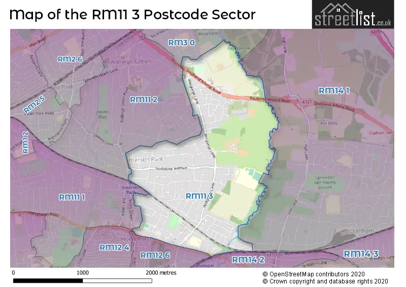
The RM11 3 Postcode shares a border with RM11 2 (HORNCHURCH ), RM12 4 (HORNCHURCH ), RM12 6 (HORNCHURCH ), RM3 0 (ROMFORD , HAROLD WOOD ), RM11 1 (HORNCHURCH ), RM14 1 (UPMINSTER) and RM14 2 (UPMINSTER, HORNCHURCH).
Map of the RM11 3 Postcode Sector
Explore the RM11 3 postcode sector by using our interactive map.
The sector is within the post town of HORNCHURCH.
RM11 3 is a postcode sector within the RM11 postcode district which is within the RM Romford postcode area.
The Royal Mail delivery office for the RM11 3 postal sector is the Hornchurch Delivery Office.
The area of the RM11 3 postcode sector is 1.57 square miles which is 4.07 square kilometres or 1,006.08 square acres.
Waterways within the RM11 3 postcode sector include the River Ingrebourne.
Your support helps keep this site running!
If you enjoy using this website, consider buying me a coffee to help cover hosting costs.


| R | M | 1 | 1 | - | 3 | X | X |
| R | M | 1 | 1 | Space | 3 | Letter | Letter |
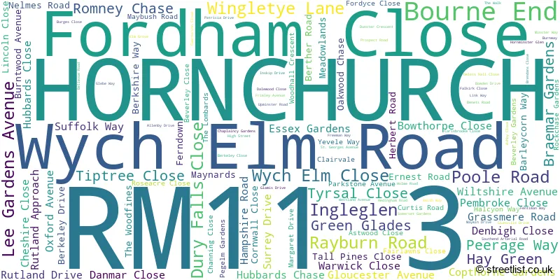
Official List of Streets
HORNCHURCH (110 Streets)
(4 Streets)
Unofficial Streets or Alternative Spellings
Gidea Park
SOUTHEND ARTERIAL ROADHORNCHURCH
BUTTS GREEN ROAD GREAT NELMES CHASE HIGHFIELD CRESCENT HIGHFIELD ROAD NORTH STREET STATION LANE SYLVAN AVENUEHORNCHURCH,
HACTON LANE UPMINSTER ROAD CLOVELLY COURT LODGE COURT MARTINSTOWN CLOSE MINSTER COURT RIDGEMONT PLACE SAINT GEORGES AVENUE THORPE LODGEROMFORD
RAVENSBOURNE CRESCENT REDDEN COURT ROADWeather Forecast for RM11 3
Weather Forecast for Romford
| Time Period | Icon | Description | Temperature | Rain Probability | Wind |
|---|---|---|---|---|---|
| 03:00 to 06:00 | Clear night | 2.0°C (feels like 0.0°C) | 0.00% | SE 4 mph | |
| 06:00 to 09:00 | Clear night | 1.0°C (feels like -1.0°C) | 0.00% | ESE 4 mph | |
| 09:00 to 12:00 | Sunny day | 2.0°C (feels like -1.0°C) | 0.00% | SE 4 mph | |
| 12:00 to 15:00 | Sunny day | 5.0°C (feels like 4.0°C) | 0.00% | SSE 4 mph | |
| 15:00 to 18:00 | Sunny day | 7.0°C (feels like 5.0°C) | 0.00% | SSE 4 mph | |
| 18:00 to 21:00 | Clear night | 4.0°C (feels like 3.0°C) | 0.00% | S 4 mph | |
| 21:00 to 00:00 | Clear night | 3.0°C (feels like 1.0°C) | 1.00% | S 4 mph |
| Time Period | Icon | Description | Temperature | Rain Probability | Wind |
|---|---|---|---|---|---|
| 00:00 to 03:00 | Clear night | 1.0°C (feels like -1.0°C) | 1.00% | S 4 mph | |
| 03:00 to 06:00 | Clear night | 0.0°C (feels like -1.0°C) | 2.00% | SSW 4 mph | |
| 06:00 to 09:00 | Cloudy | 0.0°C (feels like -2.0°C) | 6.00% | SSW 4 mph | |
| 09:00 to 12:00 | Overcast | 2.0°C (feels like 0.0°C) | 9.00% | SSW 4 mph | |
| 12:00 to 15:00 | Cloudy | 6.0°C (feels like 4.0°C) | 5.00% | SSW 7 mph | |
| 15:00 to 18:00 | Partly cloudy (day) | 8.0°C (feels like 6.0°C) | 1.00% | SSW 7 mph | |
| 18:00 to 21:00 | Partly cloudy (night) | 5.0°C (feels like 3.0°C) | 1.00% | S 7 mph | |
| 21:00 to 00:00 | Partly cloudy (night) | 4.0°C (feels like 1.0°C) | 2.00% | SSW 7 mph |
| Time Period | Icon | Description | Temperature | Rain Probability | Wind |
|---|---|---|---|---|---|
| 00:00 to 03:00 | Partly cloudy (night) | 4.0°C (feels like 1.0°C) | 3.00% | SSW 7 mph | |
| 03:00 to 06:00 | Partly cloudy (night) | 4.0°C (feels like 1.0°C) | 2.00% | S 7 mph | |
| 06:00 to 09:00 | Clear night | 4.0°C (feels like 1.0°C) | 2.00% | SSW 7 mph | |
| 09:00 to 12:00 | Partly cloudy (day) | 6.0°C (feels like 3.0°C) | 2.00% | SSW 9 mph | |
| 12:00 to 15:00 | Partly cloudy (day) | 9.0°C (feels like 6.0°C) | 3.00% | SSW 11 mph | |
| 15:00 to 18:00 | Cloudy | 10.0°C (feels like 7.0°C) | 7.00% | SSW 11 mph | |
| 18:00 to 21:00 | Overcast | 9.0°C (feels like 6.0°C) | 17.00% | SSW 11 mph | |
| 21:00 to 00:00 | Overcast | 8.0°C (feels like 6.0°C) | 18.00% | SW 9 mph |
| Time Period | Icon | Description | Temperature | Rain Probability | Wind |
|---|---|---|---|---|---|
| 00:00 to 03:00 | Clear night | 7.0°C (feels like 5.0°C) | 7.00% | WSW 7 mph | |
| 03:00 to 06:00 | Clear night | 5.0°C (feels like 3.0°C) | 5.00% | W 7 mph | |
| 06:00 to 09:00 | Clear night | 4.0°C (feels like 2.0°C) | 2.00% | WNW 4 mph | |
| 09:00 to 12:00 | Partly cloudy (day) | 4.0°C (feels like 2.0°C) | 1.00% | NW 4 mph | |
| 12:00 to 15:00 | Cloudy | 7.0°C (feels like 6.0°C) | 4.00% | NW 4 mph | |
| 15:00 to 18:00 | Cloudy | 8.0°C (feels like 7.0°C) | 5.00% | NNW 4 mph | |
| 18:00 to 21:00 | Cloudy | 5.0°C (feels like 4.0°C) | 5.00% | N 4 mph | |
| 21:00 to 00:00 | Cloudy | 4.0°C (feels like 2.0°C) | 4.00% | N 4 mph |
Schools and Places of Education Within the RM11 3 Postcode Sector
Emerson Park Academy
Academy converter
Wych Elm Road, Hornchurch, Essex, RM11 3AD
Head: Mr Scott McGuinness
Ofsted Rating: Good
Inspection: 2022-06-22 (956 days ago)
Website: Visit Emerson Park Academy Website
Phone: 01708475285
Number of Pupils: 1043
Langtons Infant School & Nursery
Community school
Westland Avenue, Hornchurch, Essex, RM11 3SD
Head: Miss Elizabeth Page
Ofsted Rating: Good
Inspection: 2023-06-28 (585 days ago)
Website: Visit Langtons Infant School & Nursery Website
Phone: 01708447866
Number of Pupils: 199
Langtons Junior Academy
Academy sponsor led
Westland Avenue, Hornchurch, Essex, RM11 3SD
Head: Mrs Anna Thorpe
Ofsted Rating: Good
Inspection: 2018-11-21 (2265 days ago)
Website: Visit Langtons Junior Academy Website
Phone: 01708442013
Number of Pupils: 214
Nelmes Primary School
Community school
Wingletye Lane, Hornchurch, Essex, RM11 3BX
Head: Mrs Kirsten Cooper
Ofsted Rating: Outstanding
Inspection: 2014-01-29 (4022 days ago)
Website: Visit Nelmes Primary School Website
Phone: 01708447676
Number of Pupils: 434
Olive AP Academy - Havering
Academy alternative provision sponsor led
Inskip Drive, Hornchurch, Essex, RM11 3UR
Head: Mr Tony Machin
Ofsted Rating: Good
Inspection: 2023-02-23 (710 days ago)
Website: Visit Olive AP Academy - Havering Website
Phone: 01708478892
Number of Pupils: 11
The Campion School
Academy converter
Wingletye Lane, Hornchurch, Essex, RM11 3BX
Head: Mr P Larner
Ofsted Rating: Good
Inspection: 2021-11-25 (1165 days ago)
Website: Visit The Campion School Website
Phone: 01708452332
Number of Pupils: 1178

House Prices in the RM11 3 Postcode Sector
| Type of Property | 2018 Average | 2018 Sales | 2017 Average | 2017 Sales | 2016 Average | 2016 Sales | 2015 Average | 2015 Sales |
|---|---|---|---|---|---|---|---|---|
| Detached | £1,073,984 | 31 | £963,747 | 53 | £864,543 | 35 | £853,230 | 50 |
| Semi-Detached | £461,097 | 49 | £465,388 | 59 | £418,935 | 62 | £365,653 | 65 |
| Terraced | £369,276 | 19 | £370,770 | 28 | £398,881 | 34 | £302,842 | 19 |
| Flats | £271,371 | 33 | £257,577 | 32 | £255,135 | 34 | £209,446 | 28 |
Important Postcodes RM11 3 in the Postcode Sector
RM11 3AD is the postcode for MAIN BUILDING (A), Emerson Park Academy, Wych Elm Road, MAIN BUILDING, Emerson Park Academy, Wych Elm Road, SPORTS BLOCK, Emerson Park Academy, Wych Elm Road, NEW BUILDING, Emerson Park Academy, Wych Elm Road, MUSIC & MEDIA BLOCK, Emerson Park Academy, Wych Elm Road, CDT BLOCK, Emerson Park Academy, Wych Elm Road, and HUMANITIES BLOCK, Emerson Park Academy, Wych Elm Road
RM11 3BX is the postcode for SIXTH FORM BLOCK, The Campion School, Wingletye Lane, The Campion School, Wingletye Lane, JUNIOR BUILDING, Nelmes Primary School, Wingletye Lane, SPORTS HALL, The Campion School, Wingletye Lane, INFANT BUILDING, Nelmes Primary School, Wingletye Lane, New Build, Nelmes Primary School, Wingletye Lane, Nelmes Primary School, Wingletye Lane, and JUNIORS BUILDING, The Campion School, Wingletye Lane
RM11 3SD is the postcode for MAIN BUILDING, Langtons Junior & Infant School, Westland Avenue, CANTEEN BUILDING, Langtons Junior & Infant School, Westland Avenue, and Langtons Junior & Infant School, Westland Avenue
RM11 3TB is the postcode for Berner Lees House, Havering Sixth Form College, Wingletye Lane, MINSTER COURT, Havering Sixth Form College, Wingletye Lane, MAIN BUILDING HAVERING CAMPUS, Havering Sixth Form College, Wingletye Lane, GATEHOUSE, Havering Sixth Form College, Wingletye Lane, BERNERS-LEE HOUSE, Havering Sixth Form College, Wingletye Lane, NEWCOURT BUILDING HAVERING CAMPUS, Havering Sixth Form College, Wingletye Lane, INTERNATIONAL HOUSE, Havering Sixth Form College, Wingletye Lane, and HORSA BUILDING, Havering Sixth Form College, Wingletye Lane
| The RM11 3 Sector is within these Local Authorities |
|
|---|---|
| The RM11 3 Sector is within these Counties |
|
| The RM11 3 Sector is within these Water Company Areas |
|