
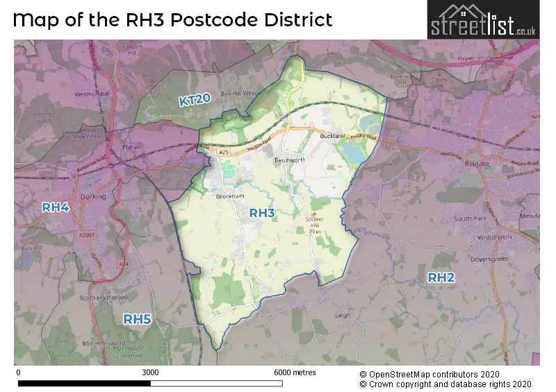
Map of the RH3 Postcode District
Explore the postcode district by using our interactive map.
Circles represent recorded crime; the larger the circle, the higher the crime rates.
Your support helps keep this site running!
If you enjoy using this website, consider buying me a coffee to help cover hosting costs.
Where is the RH3 District?
To give you an idea where the district is located we have created the following table showing nearby towns.
Nearest Towns to RH3
| Town | Distance (miles) | Direction |
|---|---|---|
| Dorking | 2.52 | W |
| Reigate | 2.88 | E |
| Redhill | 4.40 | E |
| Leatherhead | 5.11 | NNW |
| Horley | 6.29 | SE |
| Banstead | 6.84 | NNE |
| Epsom | 6.97 | N |
| Ewell | 8.16 | N |
| Crawley | 8.92 | SSE |
| Caterham | 9.04 | ENE |
| Esher | 10.31 | NNW |
| Warlingham | 10.77 | ENE |
| Oxted | 11.76 | E |
| Horsham | 12.02 | SSW |
| Walton-on-Thames | 12.32 | NNW |
| Weybridge | 12.64 | NW |
| Guildford | 13.21 | W |
| Addlestone | 13.54 | NW |
| East Grinstead | 13.68 | ESE |
| Woking | 13.77 | WNW |
The post town for this district is BETCHWORTH.
Postcode Information for District RH3 (Total Geographical Postcodes: 163)
| Location | Post Town | Sector | Number of Postcodes |
|---|---|---|---|
| BETCHWORTH | BETCHWORTH | RH3 7 | 64 |
| Brockham | BETCHWORTH | RH3 7 | 62 |
| Buckland | BETCHWORTH | RH3 7 | 23 |
| Strood Green | BETCHWORTH | RH3 7 | 14 |
The primary settlement in the RH3 postcode district is Betchworth, located in the county of Surrey in England. Other significant settlements in this area include Brockham, Buckland, and Strood Green. The main post town in the RH3 postcode district is Betchworth.
When it comes to local government, postal geography often disregards political borders. However, this district intersects the following councils: the district mostly encompasses the Mole Valley District area with a total of 145 postal codes.
The largest settlement in the RH3 postal code is Brockham followed by BETCHWORTH, and BUCKLAND.
The RH3 Postcode shares a border with KT20 (TADWORTH, KINGSWOOD, LOWER KINGSWOOD), RH2 (REIGATE, Leigh, Sidlow), RH4 (DORKING, Westcott, Pixham) and RH5 (Newdigate, Beare Green, North Holmwood).
Postcode Sectors


Dentists in the RH3 District
No dentists found in this district.
Doctors in the RH3 District
| # | Name | Address | Type | Contact |
|---|---|---|---|---|
| 1 | Brockwood Medical Practice | , BROCKHAM , BETCHWORTH , SURREY , RH3 7NJ | GP PRACTICE |
Chemists in the RH3 District
| # | Name | Address | Type | Contact |
|---|---|---|---|---|
| 1 | Brockham Green Pharmacy | BROCKHAM GREEN , BROCKHAM , BETCHWORTH , RH3 7JR | PHARMACY |
Opticians in the RH3 District
No Opticians found in this district.
Schools in the Sector
North Downs Primary School
Phase: Primary
Address: Wheelers Lane , Brockham , Betchworth
Postcode: RH3 7LA
Headteacher: Mrs Jane Douglass (Headteacher)
Ofsted Rating: Good
Stations in the Sector
Betchworth
CRS Code: BTO
Operator: GW
Line: North Downs Line
Company: Great Western Railway
Accessable Motorway Junctions
M25 J8
Average Driving Time from within the district: 10.65
Average Driving Distance: 5.74
Number of Postcodes that can access the Motorway Junction: 144
M25 J9
Average Driving Time from within the district: 11.82
Average Driving Distance: 7.52
Number of Postcodes that can access the Motorway Junction: 142
M25 J7
Average Driving Time from within the district: 13.54
Average Driving Distance: 8.70
Number of Postcodes that can access the Motorway Junction: 137
M25 J10
Average Driving Time from within the district: 15.46
Average Driving Distance: 12.70
Number of Postcodes that can access the Motorway Junction: 5
M23 J9
Average Driving Time from within the district: 15.62
Average Driving Distance: 9.52
Number of Postcodes that can access the Motorway Junction: 7
M23 J8
Average Driving Time from within the district: 17.42
Average Driving Distance: 12.71
Number of Postcodes that can access the Motorway Junction: 102
M23 J10
Average Driving Time from within the district: 19.32
Average Driving Distance: 12.03
Number of Postcodes that can access the Motorway Junction: 1
Weather Forecast for Dorking
| Time Period | Icon | Description | Temperature | Rain Probability | Wind |
|---|---|---|---|---|---|
| 03:00 to 06:00 | Overcast | 4.0°C (feels like 2.0°C) | 10.00% | SE 4 mph | |
| 06:00 to 09:00 | Overcast | 4.0°C (feels like 3.0°C) | 11.00% | SE 4 mph | |
| 09:00 to 12:00 | Overcast | 5.0°C (feels like 2.0°C) | 9.00% | SE 7 mph | |
| 12:00 to 15:00 | Overcast | 6.0°C (feels like 4.0°C) | 8.00% | SSE 9 mph | |
| 15:00 to 18:00 | Cloudy | 6.0°C (feels like 4.0°C) | 4.00% | SSE 9 mph | |
| 18:00 to 21:00 | Clear night | 4.0°C (feels like 1.0°C) | 1.00% | SSE 4 mph | |
| 21:00 to 00:00 | Clear night | 2.0°C (feels like 0.0°C) | 1.00% | SE 7 mph |
| Time Period | Icon | Description | Temperature | Rain Probability | Wind |
|---|---|---|---|---|---|
| 00:00 to 03:00 | Clear night | 2.0°C (feels like -1.0°C) | 1.00% | SSE 7 mph | |
| 03:00 to 06:00 | Clear night | 1.0°C (feels like -2.0°C) | 1.00% | SSE 7 mph | |
| 06:00 to 09:00 | Clear night | 1.0°C (feels like -2.0°C) | 1.00% | SSE 7 mph | |
| 09:00 to 12:00 | Sunny day | 2.0°C (feels like -1.0°C) | 2.00% | SSE 7 mph | |
| 12:00 to 15:00 | Sunny day | 6.0°C (feels like 4.0°C) | 3.00% | S 7 mph | |
| 15:00 to 18:00 | Sunny day | 6.0°C (feels like 5.0°C) | 2.00% | S 7 mph | |
| 18:00 to 21:00 | Clear night | 3.0°C (feels like 1.0°C) | 2.00% | S 4 mph | |
| 21:00 to 00:00 | Clear night | 1.0°C (feels like -1.0°C) | 2.00% | S 4 mph |
| Time Period | Icon | Description | Temperature | Rain Probability | Wind |
|---|---|---|---|---|---|
| 00:00 to 03:00 | Clear night | 1.0°C (feels like -1.0°C) | 3.00% | S 4 mph | |
| 03:00 to 06:00 | Clear night | 1.0°C (feels like -1.0°C) | 3.00% | S 4 mph | |
| 06:00 to 09:00 | Cloudy | 1.0°C (feels like -1.0°C) | 6.00% | S 4 mph | |
| 09:00 to 12:00 | Partly cloudy (day) | 2.0°C (feels like 0.0°C) | 4.00% | S 4 mph | |
| 12:00 to 15:00 | Overcast | 6.0°C (feels like 4.0°C) | 7.00% | SSW 9 mph | |
| 15:00 to 18:00 | Cloudy | 7.0°C (feels like 5.0°C) | 5.00% | SSW 9 mph | |
| 18:00 to 21:00 | Partly cloudy (night) | 5.0°C (feels like 2.0°C) | 3.00% | S 9 mph | |
| 21:00 to 00:00 | Partly cloudy (night) | 5.0°C (feels like 2.0°C) | 3.00% | S 9 mph |
| Time Period | Icon | Description | Temperature | Rain Probability | Wind |
|---|---|---|---|---|---|
| 00:00 to 03:00 | Partly cloudy (night) | 5.0°C (feels like 2.0°C) | 3.00% | S 9 mph | |
| 03:00 to 06:00 | Partly cloudy (night) | 5.0°C (feels like 2.0°C) | 5.00% | S 9 mph | |
| 06:00 to 09:00 | Cloudy | 5.0°C (feels like 2.0°C) | 9.00% | S 11 mph | |
| 09:00 to 12:00 | Cloudy | 6.0°C (feels like 3.0°C) | 12.00% | S 11 mph | |
| 12:00 to 15:00 | Cloudy | 9.0°C (feels like 6.0°C) | 15.00% | SSW 13 mph | |
| 15:00 to 18:00 | Cloudy | 9.0°C (feels like 6.0°C) | 16.00% | SSW 11 mph | |
| 18:00 to 21:00 | Light rain shower (night) | 8.0°C (feels like 5.0°C) | 37.00% | SW 9 mph | |
| 21:00 to 00:00 | Light rain shower (night) | 7.0°C (feels like 5.0°C) | 35.00% | SW 9 mph |
| Postal Sector | Delivery Office |
|---|---|
| RH3 7 | Dorking Delivery Office |
| R | H | 3 | - | X | X | X |
| R | H | 3 | Space | Numeric | Letter | Letter |
Street List for the RH3 District
Current Monthly Rental Prices
| # Bedrooms | Min Price | Max Price | Avg Price |
|---|---|---|---|
| £451 | £451 | £451 | |
| 2 | £1,600 | £1,600 | £1,600 |
| 3 | £2,300 | £2,300 | £2,300 |
Current House Prices
| # Bedrooms | Min Price | Max Price | Avg Price |
|---|---|---|---|
| 2 | £297,000 | £775,000 | £486,417 |
| 3 | £550,000 | £775,000 | £629,375 |
| 4 | £625,000 | £1,700,000 | £1,072,778 |
| 5 | £1,425,000 | £3,950,000 | £2,687,500 |
| 6 | £1,400,000 | £2,350,000 | £1,875,000 |
Estate Agents
| Logo | Name | Brand Name | Address | Contact Number |
|---|---|---|---|---|
 | Dorking | Seymours Estate Agents | Cummins House, 62 South Street, Dorking, Surrey, RH4 2HD | 01306 773813 |
 | Dorking | Jackson-Stops | 279 High Street, Dorking, RH4 1RL | 01306 776303 |
 | Dorking | Hamptons Sales | 251 High Street, Dorking, RH4 1YA | 01306 773811 |
 | South East | Yopa | Meridian House Wheatfield Way Hinckley LE10 1YG | 01322 952994 |
 | Dorking | White & Sons | 104 High Street Dorking Surrey RH4 1AZ | 01306 771694 |
Yearly House Price Averages for the District
| Type of Property | 2018 Average | 2018 Sales | 2017 Average | 2017 Sales | 2016 Average | 2016 Sales | 2015 Average | 2015 Sales |
|---|---|---|---|---|---|---|---|---|
| Detached | £1,000,616 | 20 | £828,548 | 21 | £943,971 | 17 | £765,397 | 34 |
| Semi-Detached | £497,176 | 17 | £486,175 | 20 | £517,159 | 23 | £531,205 | 12 |
| Terraced | £561,715 | 10 | £490,000 | 8 | £521,054 | 14 | £522,800 | 20 |
| Flats | £512,250 | 2 | £408,600 | 5 | £428,750 | 4 | £338,700 | 5 |