A wide range of spatial data has been analysed to present this overview of the RG7 6 Postcode sector. If you would like anything added, please contact us.
The RG7 6 postcode sector is within the county of Berkshire.
Did you know? According to the 2021 Census, the RG7 6 postcode sector is home to a bustling 4,257 residents!
Given that each sector allows for 400 unique postcode combinations. Letters C, I, K, M, O and V are not allowed in the last two letters of a postcode. With 197 postcodes already in use, this leaves 203 units available.
The largest settlement in the RG7 6 postal code is Upper Bucklebury followed by Bradfield, and Bradfield Southend.
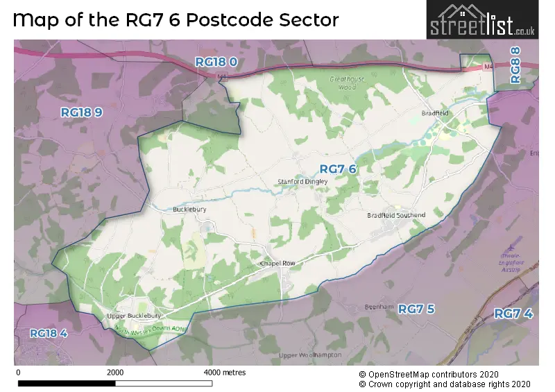
The RG7 6 Postcode shares a border with RG18 0 (Hampstead Norreys, Yattendon, THATCHAM), RG18 4 (THATCHAM), RG18 9 (Hermitage, Cold Ash, Curridge), RG7 5 (Theale, Beenham, Woolhampton) and RG8 8 (Purley On Thames, Upper Basildon, Pangbourne).
Map of the RG7 6 Postcode Sector
Explore the RG7 6 postcode sector by using our interactive map.
The sector is within the post town of READING.
RG7 6 is a postcode sector within the RG7 postcode district which is within the RG Reading postcode area.
The Royal Mail delivery office for the RG7 6 postal sector is the Southend (reading) Scale Payment Delivery Office and Thatcham Delivery Office.
The area of the RG7 6 postcode sector is 12.37 square miles which is 32.03 square kilometres or 7,914.21 square acres.
The RG7 6 postcode sector is crossed by the M4 motorway.
Waterways within the RG7 6 postcode sector include the River Pang.
Your support helps keep this site running!
If you enjoy using this website, consider buying me a coffee to help cover hosting costs.


| R | G | 7 | - | 6 | X | X |
| R | G | 7 | Space | 6 | Letter | Letter |
Official List of Streets
Bradfield Southend (13 Streets)
Bradfield (10 Streets)
Stanford Dingley (3 Streets)
(13 Streets)
Upper Bucklebury (14 Streets)
Bucklebury (9 Streets)
Southend (5 Streets)
Chapel Row (7 Streets)
Tutts Clump (3 Streets)
Unofficial Streets or Alternative Spellings
Midgham
COXS LANETHATCHAM
HARTS HILL ROADYattendon
CHAPEL LANEBeenham
BACK LANEHermitage
MARLSTON ROADWeather Forecast for RG7 6
Weather Forecast for Living Rainforest
| Time Period | Icon | Description | Temperature | Rain Probability | Wind |
|---|---|---|---|---|---|
| 00:00 to 03:00 | Cloudy | 3.0°C (feels like 0.0°C) | 4.00% | SSE 9 mph | |
| 03:00 to 06:00 | Partly cloudy (night) | 3.0°C (feels like 0.0°C) | 1.00% | SSE 7 mph | |
| 06:00 to 09:00 | Partly cloudy (night) | 2.0°C (feels like -1.0°C) | 4.00% | SSE 7 mph | |
| 09:00 to 12:00 | Sunny day | 2.0°C (feels like -1.0°C) | 0.00% | SSE 7 mph | |
| 12:00 to 15:00 | Sunny day | 6.0°C (feels like 3.0°C) | 0.00% | SSE 9 mph | |
| 15:00 to 18:00 | Sunny day | 7.0°C (feels like 4.0°C) | 0.00% | S 7 mph | |
| 18:00 to 21:00 | Clear night | 2.0°C (feels like 0.0°C) | 1.00% | SSW 4 mph | |
| 21:00 to 00:00 | Clear night | 1.0°C (feels like -1.0°C) | 3.00% | S 4 mph |
| Time Period | Icon | Description | Temperature | Rain Probability | Wind |
|---|---|---|---|---|---|
| 00:00 to 03:00 | Cloudy | 0.0°C (feels like -2.0°C) | 7.00% | SSW 4 mph | |
| 03:00 to 06:00 | Cloudy | 1.0°C (feels like -1.0°C) | 11.00% | S 4 mph | |
| 06:00 to 09:00 | Overcast | 2.0°C (feels like 0.0°C) | 9.00% | SSW 7 mph | |
| 09:00 to 12:00 | Overcast | 3.0°C (feels like 1.0°C) | 9.00% | SSW 7 mph | |
| 12:00 to 15:00 | Partly cloudy (day) | 7.0°C (feels like 4.0°C) | 3.00% | SSW 9 mph | |
| 15:00 to 18:00 | Cloudy | 8.0°C (feels like 5.0°C) | 5.00% | SSW 9 mph | |
| 18:00 to 21:00 | Partly cloudy (night) | 6.0°C (feels like 3.0°C) | 3.00% | S 9 mph | |
| 21:00 to 00:00 | Cloudy | 5.0°C (feels like 2.0°C) | 7.00% | S 9 mph |
| Time Period | Icon | Description | Temperature | Rain Probability | Wind |
|---|---|---|---|---|---|
| 00:00 to 03:00 | Cloudy | 5.0°C (feels like 2.0°C) | 6.00% | S 11 mph | |
| 03:00 to 06:00 | Partly cloudy (night) | 5.0°C (feels like 2.0°C) | 3.00% | S 9 mph | |
| 06:00 to 09:00 | Overcast | 5.0°C (feels like 2.0°C) | 8.00% | SSW 11 mph | |
| 09:00 to 12:00 | Overcast | 7.0°C (feels like 3.0°C) | 9.00% | SSW 11 mph | |
| 12:00 to 15:00 | Overcast | 9.0°C (feels like 6.0°C) | 12.00% | SSW 16 mph | |
| 15:00 to 18:00 | Overcast | 9.0°C (feels like 7.0°C) | 21.00% | SSW 13 mph | |
| 18:00 to 21:00 | Light rain | 8.0°C (feels like 6.0°C) | 54.00% | SW 11 mph | |
| 21:00 to 00:00 | Partly cloudy (night) | 7.0°C (feels like 4.0°C) | 9.00% | WSW 9 mph |
| Time Period | Icon | Description | Temperature | Rain Probability | Wind |
|---|---|---|---|---|---|
| 00:00 to 03:00 | Clear night | 6.0°C (feels like 3.0°C) | 6.00% | W 9 mph | |
| 03:00 to 06:00 | Clear night | 4.0°C (feels like 2.0°C) | 3.00% | W 7 mph | |
| 06:00 to 09:00 | Clear night | 3.0°C (feels like 0.0°C) | 2.00% | WNW 7 mph | |
| 09:00 to 12:00 | Partly cloudy (day) | 3.0°C (feels like 1.0°C) | 2.00% | WNW 4 mph | |
| 12:00 to 15:00 | Cloudy | 7.0°C (feels like 5.0°C) | 4.00% | NNW 7 mph | |
| 15:00 to 18:00 | Cloudy | 8.0°C (feels like 6.0°C) | 5.00% | N 4 mph | |
| 18:00 to 21:00 | Cloudy | 4.0°C (feels like 2.0°C) | 4.00% | N 4 mph | |
| 21:00 to 00:00 | Cloudy | 2.0°C (feels like 0.0°C) | 4.00% | E 4 mph |
Schools and Places of Education Within the RG7 6 Postcode Sector
Bradfield C.E. Primary School
Voluntary aided school
Cock Lane, Reading, Berkshire, RG7 6HR
Head: Miss Jessica Davies
Ofsted Rating: Good
Inspection: 2019-11-07 (1913 days ago)
Website: Visit Bradfield C.E. Primary School Website
Phone: 01189744304
Number of Pupils: 145
Bucklebury C.E. Primary School
Voluntary controlled school
Blacklands Road, Reading, Berkshire, RG7 6QP
Head: Mr A Higgs
Ofsted Rating: Good
Inspection: 2019-02-26 (2167 days ago)
Website: Visit Bucklebury C.E. Primary School Website
Phone: 01635862965
Number of Pupils: 121
House Prices in the RG7 6 Postcode Sector
| Type of Property | 2018 Average | 2018 Sales | 2017 Average | 2017 Sales | 2016 Average | 2016 Sales | 2015 Average | 2015 Sales |
|---|---|---|---|---|---|---|---|---|
| Detached | £836,284 | 29 | £719,565 | 23 | £705,357 | 21 | £774,909 | 39 |
| Semi-Detached | £409,606 | 9 | £417,981 | 8 | £444,273 | 11 | £389,750 | 14 |
| Terraced | £0 | 0 | £349,700 | 5 | £356,250 | 2 | £269,290 | 5 |
| Flats | £220,000 | 1 | £0 | 0 | £162,000 | 1 | £160,347 | 3 |
Important Postcodes RG7 6 in the Postcode Sector
RG7 6NS is the postcode for Chapel Row Surgery, The Avenue
RG7 6QP is the postcode for Bucklebury C of E Primary School, Blacklands Road
| The RG7 6 Sector is within these Local Authorities |
|
|---|---|
| The RG7 6 Sector is within these Counties |
|
| The RG7 6 Sector is within these Water Company Areas |
|