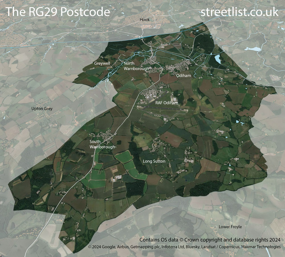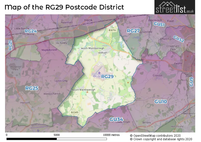
Map of the RG29 Postcode District
Explore the postcode district by using our interactive map.
Circles represent recorded crime; the larger the circle, the higher the crime rates.
Your support helps keep this site running!
If you enjoy using this website, consider buying me a coffee to help cover hosting costs.
Map of the RG29 Postcode District

Where is the RG29 District?
To give you an idea where the district is located we have created the following table showing nearby towns.
Nearest Towns to RG29
| Town | Distance (miles) | Direction |
|---|---|---|
| Fleet | 5.38 | NE |
| Alton | 6.09 | SSW |
| Farnham | 6.41 | ESE |
| Basingstoke | 6.70 | WNW |
| Aldershot | 7.95 | E |
| Farnborough | 9.05 | ENE |
| Bordon | 9.05 | SSE |
| Yateley | 9.10 | NE |
| Blackwater | 9.74 | NE |
| Sandhurst | 9.85 | NE |
| Frimley | 10.44 | ENE |
| Camberley | 11.29 | NE |
| Crowthorne | 11.35 | NE |
| Tadley | 12.27 | NW |
| Wokingham | 13.07 | NNE |
| New Alresford | 13.73 | SW |
| Haslemere | 14.35 | SE |
| Godalming | 14.68 | ESE |
| Bracknell | 15.10 | NNE |
| Reading | 15.23 | N |
The post town for this district is HOOK.
Postcode Information for District RG29 (Total Geographical Postcodes: 310)
| Location | Post Town | Sector | Number of Postcodes |
|---|---|---|---|
| Odiham | HOOK | RG29 1 | 176 |
| North Warnborough | HOOK | RG29 1 | 60 |
| South Warnborough | HOOK | RG29 1 | 34 |
| Long Sutton | HOOK | RG29 1 | 24 |
| Greywell | HOOK | RG29 1 | 13 |
| Well | HOOK | RG29 1 | 3 |
Retail and Shopping in RG29
Street
Town
Locality
Number of Shops
Central Postcode
View on Google Maps
HIGH STREET
HOOK
ODIHAM
31
RG29 1LN
View on Google Maps
| Street | Town | Locality | Number of Shops | Central Postcode | View on Google Maps |
|---|---|---|---|---|---|
| HIGH STREET | HOOK | ODIHAM | 31 | RG29 1LN | View on Google Maps |
The primary settlement in the RG29 postcode district is Odiham, located in Hampshire county. Other significant settlements in the district include North Warnborough, South Warnborough, Long Sutton, and Greywell. The post town for this district is Hook.
When it comes to local government, postal geography often disregards political borders. However, this district intersects the following councils: the district mostly encompasses the Hart District area with a total of 271 postal codes.
The largest settlement in the RG29 postal code is Odiham followed by North Warnborough, and South Warnborough.
The RG29 Postcode shares a border with GU10 (Tongham, Wrecclesham, Lower Bourne), GU34 (ALTON, Four Marks, Medstead), RG25 (Overton, North Waltham, Upton Grey) and RG27 (HOOK, Hartley Wintney, Sherfield-on-Loddon).
Postcode Sectors


Dentists in the RG29 District
| # | Name | Address | Type | Contact |
|---|---|---|---|---|
| 1 | Odiham Dental Centre | THE DENTAL CENTRE , ODIHAM , HOOK , HAMPSHIRE , RG29 1QT | GENERAL DENTAL PRACTICE | |
| 2 | King Street Dental Practice | KING STREET , ODIHAM , HOOK , HAMPSHIRE , RG29 1NJ | GENERAL DENTAL PRACTICE | |
| 3 | Odiham Dental Care | 45B HIGH STREET , ODIHAM , HOOK , HAMPSHIRE , RG29 1LF | GENERAL DENTAL PRACTICE |
Doctors in the RG29 District
| # | Name | Address | Type | Contact |
|---|---|---|---|---|
| 1 | Odiham Health Centre | , ODIHAM , HOOK , HAMPSHIRE , RG29 1JY | GP PRACTICE |
Chemists in the RG29 District
| # | Name | Address | Type | Contact |
|---|---|---|---|---|
| 1 | Touchwood Pharmacy | 138 HIGH STREET , ODIHAM , HOOK , RG29 1LT | PHARMACY |
Opticians in the RG29 District
| # | Name | Address | Type | Contact |
|---|---|---|---|---|
| 1 | THE OPTICIAN ODIHAM | 113A HIGH STREET , ODIHAM , HOOK , HAMPSHIRE , RG29 1LA | OPTICAL SITE |
Schools in the Sector
Robert May's School
Phase: Secondary
Address: West Street , Odiham , Hook
Postcode: RG29 1NA
Headteacher: Mrs Rea Mitchell (Headteacher)
Ofsted Rating: Good
Mayhill Junior School
Phase: Primary
Address: The Bury , Odiham , Hook
Postcode: RG29 1NB
Headteacher: Mrs Sarah McGillivray (Headteacher)
Ofsted Rating: Good
Buryfields Infant School
Phase: Primary
Address: Buryfields , Odiham , Hook
Postcode: RG29 1NE
Headteacher: Miss Lauren English (Headteacher)
Ofsted Rating: Good
Long Sutton Church of England Primary School
Phase: Primary
Address: Hyde Road , Long Sutton , Hook
Postcode: RG29 1ST
Headteacher: Mrs Selena Cameron (Acting Headteacher)
Ofsted Rating: Good
Stations in the Sector
No stations found in this postcode district.
Accessable Motorway Junctions
M3 J5
Average Driving Time from within the district: 3.90
Average Driving Distance: 2.58
Number of Postcodes that can access the Motorway Junction: 271
M3 J6
Average Driving Time from within the district: 8.13
Average Driving Distance: 6.77
Number of Postcodes that can access the Motorway Junction: 271
M3 J4A
Average Driving Time from within the district: 11.48
Average Driving Distance: 10.26
Number of Postcodes that can access the Motorway Junction: 271
M3 J4
Average Driving Time from within the district: 12.32
Average Driving Distance: 11.34
Number of Postcodes that can access the Motorway Junction: 204
M3 J7
Average Driving Time from within the district: 12.66
Average Driving Distance: 11.48
Number of Postcodes that can access the Motorway Junction: 262
M4 J11
Average Driving Time from within the district: 15.32
Average Driving Distance: 12.15
Number of Postcodes that can access the Motorway Junction: 9
Weather Forecast for Odiham
| Time Period | Icon | Description | Temperature | Rain Probability | Wind |
|---|---|---|---|---|---|
| 03:00 to 06:00 | Cloudy | 2.0°C (feels like -1.0°C) | 9.00% | E 7 mph | |
| 06:00 to 09:00 | Fog | 2.0°C (feels like -1.0°C) | 19.00% | ENE 7 mph | |
| 09:00 to 12:00 | Fog | 2.0°C (feels like 0.0°C) | 19.00% | ENE 7 mph | |
| 12:00 to 15:00 | Overcast | 4.0°C (feels like 1.0°C) | 14.00% | ENE 7 mph | |
| 15:00 to 18:00 | Overcast | 5.0°C (feels like 2.0°C) | 17.00% | NE 7 mph | |
| 18:00 to 21:00 | Overcast | 4.0°C (feels like 2.0°C) | 19.00% | NE 7 mph | |
| 21:00 to 00:00 | Overcast | 4.0°C (feels like 2.0°C) | 20.00% | NE 7 mph |
| Time Period | Icon | Description | Temperature | Rain Probability | Wind |
|---|---|---|---|---|---|
| 00:00 to 03:00 | Light rain | 4.0°C (feels like 1.0°C) | 49.00% | N 7 mph | |
| 03:00 to 06:00 | Light rain | 4.0°C (feels like 1.0°C) | 50.00% | NNW 7 mph | |
| 06:00 to 09:00 | Overcast | 3.0°C (feels like 1.0°C) | 20.00% | NW 9 mph | |
| 09:00 to 12:00 | Overcast | 3.0°C (feels like 0.0°C) | 19.00% | WSW 9 mph | |
| 12:00 to 15:00 | Overcast | 5.0°C (feels like 2.0°C) | 15.00% | WSW 11 mph | |
| 15:00 to 18:00 | Cloudy | 6.0°C (feels like 4.0°C) | 13.00% | WSW 9 mph | |
| 18:00 to 21:00 | Cloudy | 5.0°C (feels like 3.0°C) | 12.00% | SW 9 mph | |
| 21:00 to 00:00 | Cloudy | 5.0°C (feels like 2.0°C) | 14.00% | SW 9 mph |
| Postal Sector | Delivery Office |
|---|---|
| RG29 1 | Hook Delivery Office |
| R | G | 2 | 9 | - | X | X | X |
| R | G | 2 | 9 | Space | Numeric | Letter | Letter |
Tourist Attractions
We found 1 visitor attractions.
| Galleon Marine |
|---|
| Leisure / Theme Parks |
| Leisure / Theme Park |
| View Galleon Marine on Google Maps |
Street List for the RG29 District
Current Monthly Rental Prices
| # Bedrooms | Min Price | Max Price | Avg Price |
|---|---|---|---|
| 1 | £725 | £1,000 | £863 |
| 2 | £1,500 | £1,600 | £1,533 |
| 3 | £2,995 | £2,995 | £2,995 |
Current House Prices
| # Bedrooms | Min Price | Max Price | Avg Price |
|---|---|---|---|
| 1 | £125,000 | £400,000 | £216,667 |
| 2 | £160,000 | £550,000 | £369,091 |
| 3 | £400,000 | £1,250,000 | £591,495 |
| 4 | £550,000 | £1,500,000 | £872,222 |
| 5 | £950,000 | £2,800,000 | £1,875,000 |
Estate Agents
| Logo | Name | Brand Name | Address | Contact Number |
|---|---|---|---|---|
 | Odiham | McCarthy Holden | 95 High Street, Odiham, RG29 1LA | 01256 633459 |
 | Hook | Bridges Estate Agents | 3 Fairholme Parade Station Road Hook RG27 9HE | 01252 221955 |
 | Hook | Mackenzie Smith | 1 Aldridge House, Elms Road, Hook RG27 9DG | 01256 633473 |
 | Covering North Hampshire | Knight Frank | Covering North Hampshire | 01256 236584 |
 | Odiham | Strutt & Parker | 82 High Street, Odiham, Hampshire, RG29 1LP | 01256 577088 |
Yearly House Price Averages for the District
| Type of Property | 2018 Average | 2018 Sales | 2017 Average | 2017 Sales | 2016 Average | 2016 Sales | 2015 Average | 2015 Sales |
|---|---|---|---|---|---|---|---|---|
| Detached | £789,965 | 55 | £728,564 | 44 | £702,925 | 48 | £655,137 | 30 |
| Semi-Detached | £432,535 | 24 | £494,535 | 23 | £420,519 | 27 | £477,567 | 21 |
| Terraced | £404,340 | 23 | £355,547 | 17 | £386,598 | 24 | £416,309 | 16 |
| Flats | £261,050 | 9 | £163,408 | 6 | £217,000 | 5 | £198,328 | 9 |
