A wide range of spatial data has been analysed to present this overview of the PR25 1 Postcode sector. If you would like anything added, please contact us.
The PR25 1 postcode sector is within the county of Lancashire.
Did you know? According to the 2021 Census, the PR25 1 postcode sector is home to a bustling 8,331 residents!
Given that each sector allows for 400 unique postcode combinations. Letters C, I, K, M, O and V are not allowed in the last two letters of a postcode. With 174 postcodes already in use, this leaves 226 units available.
The PR25 1 postal code covers the settlement of LEYLAND.
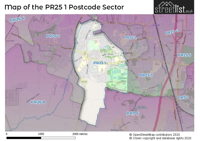
The PR25 1 Postcode shares a border with PR25 2 (LEYLAND), PR26 7 (LEYLAND, Moss Side, Midge Hall), PR26 8 (LEYLAND), PR7 6 (Euxton, Eccleston) and PR25 3 (LEYLAND, Farington).
Map of the PR25 1 Postcode Sector
Explore the PR25 1 postcode sector by using our interactive map.
The sector is within the post town of LEYLAND.
PR25 1 is a postcode sector within the PR25 postcode district which is within the PR Preston postcode area.
The Royal Mail delivery office for the PR25 1 postal sector is the Leyland Delivery Office.
The area of the PR25 1 postcode sector is 1.19 square miles which is 3.08 square kilometres or 762.26 square acres.
Waterways within the PR25 1 postcode sector include the River Lostock.
Your support helps keep this site running!
If you enjoy using this website, consider buying me a coffee to help cover hosting costs.


| P | R | 2 | 5 | - | 1 | X | X |
| P | R | 2 | 5 | Space | 1 | Letter | Letter |
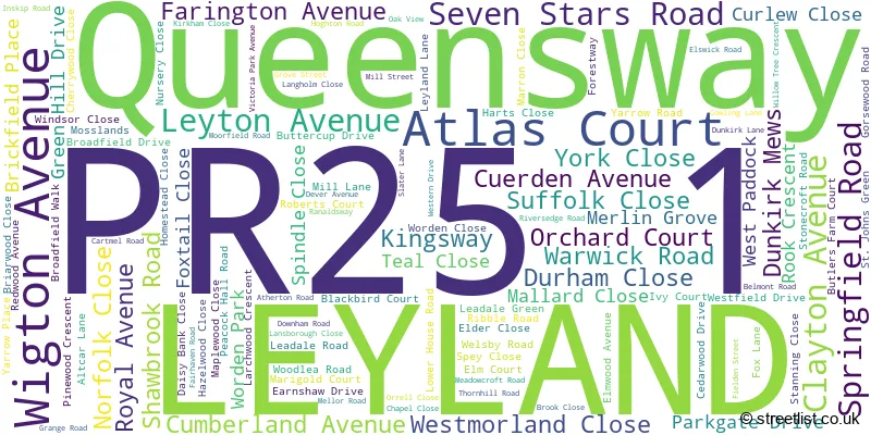
Official List of Streets
LEYLAND (121 Streets)
Unofficial Streets or Alternative Spellings
Weather Forecast for PR25 1
Weather Forecast for Leyland
| Time Period | Icon | Description | Temperature | Rain Probability | Wind |
|---|---|---|---|---|---|
| 03:00 to 06:00 | Cloudy | 4.0°C (feels like 2.0°C) | 10.00% | SSE 4 mph | |
| 06:00 to 09:00 | Cloudy | 4.0°C (feels like 2.0°C) | 9.00% | SSE 7 mph | |
| 09:00 to 12:00 | Overcast | 4.0°C (feels like 1.0°C) | 11.00% | SSE 7 mph | |
| 12:00 to 15:00 | Overcast | 5.0°C (feels like 3.0°C) | 10.00% | SSE 7 mph | |
| 15:00 to 18:00 | Overcast | 5.0°C (feels like 3.0°C) | 11.00% | SSE 7 mph | |
| 18:00 to 21:00 | Cloudy | 4.0°C (feels like 2.0°C) | 8.00% | SSE 4 mph | |
| 21:00 to 00:00 | Cloudy | 4.0°C (feels like 1.0°C) | 7.00% | SE 4 mph |
| Time Period | Icon | Description | Temperature | Rain Probability | Wind |
|---|---|---|---|---|---|
| 00:00 to 03:00 | Overcast | 3.0°C (feels like 0.0°C) | 9.00% | SE 4 mph | |
| 03:00 to 06:00 | Cloudy | 2.0°C (feels like 0.0°C) | 7.00% | ESE 4 mph | |
| 06:00 to 09:00 | Cloudy | 1.0°C (feels like -1.0°C) | 6.00% | ESE 4 mph | |
| 09:00 to 12:00 | Cloudy | 2.0°C (feels like -1.0°C) | 7.00% | ESE 4 mph | |
| 12:00 to 15:00 | Cloudy | 4.0°C (feels like 2.0°C) | 7.00% | ESE 4 mph | |
| 15:00 to 18:00 | Cloudy | 4.0°C (feels like 3.0°C) | 7.00% | E 4 mph | |
| 18:00 to 21:00 | Cloudy | 2.0°C (feels like 0.0°C) | 6.00% | ESE 4 mph | |
| 21:00 to 00:00 | Cloudy | 2.0°C (feels like 0.0°C) | 9.00% | SE 4 mph |
| Time Period | Icon | Description | Temperature | Rain Probability | Wind |
|---|---|---|---|---|---|
| 00:00 to 03:00 | Overcast | 2.0°C (feels like 0.0°C) | 16.00% | SE 4 mph | |
| 03:00 to 06:00 | Overcast | 2.0°C (feels like 0.0°C) | 16.00% | SSE 4 mph | |
| 06:00 to 09:00 | Overcast | 2.0°C (feels like 0.0°C) | 18.00% | S 4 mph | |
| 09:00 to 12:00 | Overcast | 3.0°C (feels like 0.0°C) | 16.00% | S 7 mph | |
| 12:00 to 15:00 | Overcast | 5.0°C (feels like 2.0°C) | 14.00% | SSW 7 mph | |
| 15:00 to 18:00 | Cloudy | 5.0°C (feels like 3.0°C) | 16.00% | SSW 7 mph | |
| 18:00 to 21:00 | Cloudy | 4.0°C (feels like 2.0°C) | 13.00% | SSW 7 mph | |
| 21:00 to 00:00 | Cloudy | 4.0°C (feels like 2.0°C) | 12.00% | S 7 mph |
Schools and Places of Education Within the PR25 1 Postcode Sector
Academy@Worden
Academy converter
Westfield Drive, Leyland, Lancashire, PR25 1QX
Head: Mr Alan Hammersley
Ofsted Rating: Good
Inspection: 2020-01-09 (1839 days ago)
Website: Visit Academy@Worden Website
Phone: 01772421021
Number of Pupils: 545
Golden Hill Pupil Referral Unit
Pupil referral unit
Earnshaw Drive, Leyland, Lancashire, PR25 1QS
Head: Mrs Allison Collinge
Ofsted Rating: Outstanding
Inspection: 2023-07-04 (567 days ago)
Website: Visit Golden Hill Pupil Referral Unit Website
Phone: 01772904780
Number of Pupils: 16
Leyland St Andrew's Church of England Infant School
Voluntary controlled school
Woodlea Road, Preston, Lancashire, PR25 1JL
Head: Mrs Jayne Woan
Ofsted Rating: Good
Inspection: 2023-05-17 (615 days ago)
Website: Visit Leyland St Andrew's Church of England Infant School Website
Phone: 01772423339
Number of Pupils: 152
Seven Stars Primary School
Community school
Peacock Hall Road, Leyland, Lancashire, PR25 1TD
Head: Mr Mike Mitchell
Ofsted Rating: Good
Inspection: 2022-07-06 (930 days ago)
Website: Visit Seven Stars Primary School Website
Phone: 01772422503
Number of Pupils: 207
St Anne's Catholic Primary School
Voluntary aided school
Slater Lane, Leyland, Lancashire, PR25 1TL
Head: Mrs E Darnell
Ofsted Rating: Good
Inspection: 2022-10-19 (825 days ago)
Website: Visit St Anne's Catholic Primary School Website
Phone: 01772422769
Number of Pupils: 182
St Mary's Catholic High School
Voluntary aided school
Royal Avenue, Leyland, Lancashire, PR25 1BS
Head: Mr Phil Thompson
Ofsted Rating: Good
Inspection: 2020-01-22 (1826 days ago)
Website: Visit St Mary's Catholic High School Website
Phone: 01772421909
Number of Pupils: 798
Woodlea Junior School
Community school
Woodlea Road, Leyland, Lancashire, PR25 1JL
Head: Mrs Jillian Shorrocks
Ofsted Rating: Good
Inspection: 2023-03-30 (663 days ago)
Website: Visit Woodlea Junior School Website
Phone: 01772421992
Number of Pupils: 250

House Prices in the PR25 1 Postcode Sector
| Type of Property | 2018 Average | 2018 Sales | 2017 Average | 2017 Sales | 2016 Average | 2016 Sales | 2015 Average | 2015 Sales |
|---|---|---|---|---|---|---|---|---|
| Detached | £244,383 | 14 | £213,618 | 17 | £212,941 | 13 | £177,875 | 20 |
| Semi-Detached | £137,474 | 51 | £141,090 | 49 | £126,875 | 53 | £121,817 | 63 |
| Terraced | £115,168 | 28 | £123,121 | 35 | £102,665 | 34 | £94,017 | 29 |
| Flats | £98,063 | 4 | £76,688 | 8 | £103,475 | 2 | £100,817 | 3 |
Important Postcodes PR25 1 in the Postcode Sector
PR25 1BS is the postcode for PASTORAL BLOCK, St. Marys RC School, Royal Avenue, St. Marys RC School, Royal Avenue, SPORTS HALL, St. Marys RC School, Royal Avenue, and MAIN BUILDING, St. Marys RC School, Royal Avenue
PR25 1BX is the postcode for Wade Hall Childrens Centre, 75 Royal Avenue
PR25 1DH is the postcode for South Ribble Borough Council, Civic Centre, West Paddock
PR25 1HR is the postcode for Leyland Youth & Community Centre, West Paddock, South Ribble Day Services, Lancashire County Council, West Paddock, Lancashire County Council, West Paddock, MAIN BUILDING, Lancashire County Council, West Paddock, and Leyland West Paddock Neighbourhood Centre, West Paddock
PR25 1JL is the postcode for St. Andrews C of E Infant School, Woodlea Road, and Woodlea Junior School, Woodlea Road
PR25 1LB is the postcode for Lancashire Fire & Rescue Service, Fire Station, Broadfield Drive
PR25 1NB is the postcode for Broadfield House HFE, Broadfield Walk, and Broadfield House Home for the Aged, Broadfield Walk
PR25 1QS is the postcode for Golden Hill (Short Stay) School, Earnshaw Drive, and Golden Hill Short Stay School, Earnshaw Drive
PR25 1QX is the postcode for Academy @ Worden, Westfield Drive, MAIN BUILDING, Worden Sports College, Westfield Drive, and Worden Sports College, Westfield Drive
PR25 1RP is the postcode for Lancashire County Council, The Westfield Centre, Redwood Avenue
PR25 1TD is the postcode for Seven Stars Primary School, Peacock Hall Road, INFANT SCHOOL, Seven Stars Primary School, Peacock Hall Road, and JUNIOR SCHOOL, Seven Stars Primary School, Peacock Hall Road
PR25 1TL is the postcode for MAIN BUILDING, St. Annes School, Slater Lane, MAIN BUILDING, St. Annes Catholic Primary School, Slater Lane, and St. Annes School, Slater Lane
| The PR25 1 Sector is within these Local Authorities |
|
|---|---|
| The PR25 1 Sector is within these Counties |
|
| The PR25 1 Sector is within these Water Company Areas |
|