A wide range of spatial data has been analysed to present this overview of the PL5 4 Postcode sector. If you would like anything added, please contact us.
The PL5 4 postcode sector is within the county of Devon.
Did you know? According to the 2021 Census, the PL5 4 postcode sector is home to a bustling 9,810 residents!
Given that each sector allows for 400 unique postcode combinations. Letters C, I, K, M, O and V are not allowed in the last two letters of a postcode. With 179 postcodes already in use, this leaves 221 units available.
The largest settlements in the PL5 4 postal code are PLYMOUTH and Tamerton Foliot.
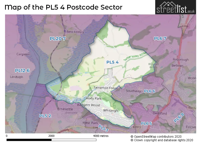
The PL5 4 Postcode shares a border with PL20 7 (Bere Alston, Horrabridge, Buckland Monachorum), PL5 2 (PLYMOUTH, Higher St. Budeaux), PL5 3 (PLYMOUTH), PL6 5 (PLYMOUTH, Derriford, Eggbuckland), PL6 6 (PLYMOUTH, Derriford) and PL6 7 (PLYMOUTH, Roborough, Glenholt Park).
Map of the PL5 4 Postcode Sector
Explore the PL5 4 postcode sector by using our interactive map.
The sector is within the post town of PLYMOUTH.
PL5 4 is a postcode sector within the PL5 postcode district which is within the PL Plymouth postcode area.
The Royal Mail delivery office for the PL5 4 postal sector is the West Park Delivery Office.
The area of the PL5 4 postcode sector is 3.97 square miles which is 10.28 square kilometres or 2,541.05 square acres.
Your support helps keep this site running!
If you enjoy using this website, consider buying me a coffee to help cover hosting costs.

| P | L | 5 | - | 4 | X | X |
| P | L | 5 | Space | 4 | Letter | Letter |
Official List of Streets
(7 Streets)
PLYMOUTH (48 Streets)
Tamerton Foliot (34 Streets)
Whitleigh (1 Streets)
Unofficial Streets or Alternative Spellings
Weather Forecast for PL5 4
Weather Forecast for Whitleigh
| Time Period | Icon | Description | Temperature | Rain Probability | Wind |
|---|---|---|---|---|---|
| 12:00 to 15:00 | Cloudy | 9.0°C (feels like 6.0°C) | 3.00% | SSE 11 mph | |
| 15:00 to 18:00 | Cloudy | 8.0°C (feels like 5.0°C) | 4.00% | SSE 11 mph | |
| 18:00 to 21:00 | Cloudy | 8.0°C (feels like 5.0°C) | 4.00% | SSE 11 mph | |
| 21:00 to 00:00 | Overcast | 7.0°C (feels like 4.0°C) | 9.00% | SSE 13 mph |
| Time Period | Icon | Description | Temperature | Rain Probability | Wind |
|---|---|---|---|---|---|
| 00:00 to 03:00 | Overcast | 7.0°C (feels like 4.0°C) | 10.00% | SSE 16 mph | |
| 03:00 to 06:00 | Overcast | 6.0°C (feels like 3.0°C) | 10.00% | SSE 16 mph | |
| 06:00 to 09:00 | Overcast | 6.0°C (feels like 3.0°C) | 17.00% | SSE 13 mph | |
| 09:00 to 12:00 | Overcast | 7.0°C (feels like 3.0°C) | 24.00% | SSE 11 mph | |
| 12:00 to 15:00 | Light rain | 8.0°C (feels like 5.0°C) | 41.00% | S 11 mph | |
| 15:00 to 18:00 | Cloudy | 8.0°C (feels like 6.0°C) | 12.00% | SE 9 mph | |
| 18:00 to 21:00 | Partly cloudy (night) | 7.0°C (feels like 4.0°C) | 5.00% | SE 7 mph | |
| 21:00 to 00:00 | Partly cloudy (night) | 5.0°C (feels like 3.0°C) | 3.00% | S 4 mph |
| Time Period | Icon | Description | Temperature | Rain Probability | Wind |
|---|---|---|---|---|---|
| 00:00 to 03:00 | Cloudy | 5.0°C (feels like 3.0°C) | 7.00% | SSE 7 mph | |
| 03:00 to 06:00 | Cloudy | 6.0°C (feels like 4.0°C) | 8.00% | SSE 7 mph | |
| 06:00 to 09:00 | Cloudy | 6.0°C (feels like 4.0°C) | 7.00% | S 9 mph | |
| 09:00 to 12:00 | Cloudy | 7.0°C (feels like 5.0°C) | 7.00% | S 9 mph | |
| 12:00 to 15:00 | Cloudy | 10.0°C (feels like 7.0°C) | 7.00% | SSW 13 mph | |
| 15:00 to 18:00 | Cloudy | 10.0°C (feels like 7.0°C) | 5.00% | SSW 16 mph | |
| 18:00 to 21:00 | Cloudy | 9.0°C (feels like 6.0°C) | 6.00% | S 13 mph | |
| 21:00 to 00:00 | Cloudy | 9.0°C (feels like 6.0°C) | 7.00% | S 16 mph |
| Time Period | Icon | Description | Temperature | Rain Probability | Wind |
|---|---|---|---|---|---|
| 00:00 to 03:00 | Cloudy | 9.0°C (feels like 6.0°C) | 11.00% | S 18 mph | |
| 03:00 to 06:00 | Cloudy | 9.0°C (feels like 6.0°C) | 13.00% | S 18 mph | |
| 06:00 to 09:00 | Cloudy | 9.0°C (feels like 6.0°C) | 20.00% | SSW 18 mph | |
| 09:00 to 12:00 | Light rain | 10.0°C (feels like 6.0°C) | 53.00% | SSW 18 mph | |
| 12:00 to 15:00 | Heavy rain | 10.0°C (feels like 7.0°C) | 76.00% | SW 18 mph | |
| 15:00 to 18:00 | Heavy rain | 10.0°C (feels like 7.0°C) | 73.00% | WSW 13 mph | |
| 18:00 to 21:00 | Light rain | 9.0°C (feels like 6.0°C) | 49.00% | W 11 mph | |
| 21:00 to 00:00 | Partly cloudy (night) | 7.0°C (feels like 5.0°C) | 10.00% | WNW 9 mph |
Schools and Places of Education Within the PL5 4 Postcode Sector
Brook Green Centre for Learning
Community special school
Bodmin Road, Plymouth, Devon, PL5 4DZ
Head: Mrs Sara Jordan
Ofsted Rating: Outstanding
Inspection: 2023-09-14 (506 days ago)
Website: Visit Brook Green Centre for Learning Website
Phone: 01752773875
Number of Pupils: 103
Sir John Hunt Community Sports College
Foundation school
Lancaster Gardens, Plymouth, Devon, PL5 4AA
Head: Mrs Julie Bevan
Ofsted Rating: Good
Inspection: 2022-09-22 (863 days ago)
Website: Visit Sir John Hunt Community Sports College Website
Phone: 01752201020
Number of Pupils: 793
St Peter's RC Primary School
Academy converter
Brentford Avenue, Plymouth, Devon, PL5 4HD
Head: Mrs Esther Archer
Ofsted Rating: Good
Inspection: 2023-03-21 (683 days ago)
Website: Visit St Peter's RC Primary School Website
Phone: 01752217010
Number of Pupils: 131
Whitleigh Community Primary School
Foundation school
Lancaster Gardens, Plymouth, Devon, PL5 4AA
Head: Mr Mark Dyson
Ofsted Rating: Good
Inspection: 2022-12-14 (780 days ago)
Website: Visit Whitleigh Community Primary School Website
Phone: 01752706383
Number of Pupils: 389
Woodfield Primary School
Academy converter
Taunton Avenue, Plymouth, Devon, PL5 4HW
Head: Miss Tessa Saunders
Ofsted Rating: Good
Inspection: 2019-10-31 (1920 days ago)
Website: Visit Woodfield Primary School Website
Phone: 01752706384
Number of Pupils: 228
House Prices in the PL5 4 Postcode Sector
| Type of Property | 2018 Average | 2018 Sales | 2017 Average | 2017 Sales | 2016 Average | 2016 Sales | 2015 Average | 2015 Sales |
|---|---|---|---|---|---|---|---|---|
| Detached | £431,000 | 4 | £232,500 | 5 | £336,731 | 13 | £211,000 | 3 |
| Semi-Detached | £152,589 | 28 | £160,975 | 35 | £153,823 | 39 | £150,823 | 43 |
| Terraced | £136,384 | 52 | £136,735 | 79 | £135,353 | 76 | £128,072 | 51 |
| Flats | £89,450 | 10 | £99,200 | 15 | £91,274 | 19 | £88,635 | 20 |
Important Postcodes PL5 4 in the Postcode Sector
PL5 4AA is the postcode for Whitleigh Community Primary School, Lancaster Gardens, SPORTS HALL, Sir John Hunt Secondary School, Lancaster Gardens, Sir John Hunt Secondary School, Lancaster Gardens, and SIXTH FORM BLOCK, Sir John Hunt Secondary School, Lancaster Gardens
PL5 4DD is the postcode for Plymouth City Council, Whitleigh Residential Home, Whitleigh Green
PL5 4DU is the postcode for The Budshead Medical Centre, 433 Budshead Road
PL5 4DZ is the postcode for Brook Green Centre for Learning, Bodmin Road, and Brook Green Centre for Learning, Bodmin Road.
PL5 4HD is the postcode for St. Peters RC Primary School, Brentford Avenue
PL5 4HW is the postcode for The Reatch Centre, Taunton Avenue, Woodfield Primary School, Taunton Avenue, and Vine 1, Taunton Avenue
PL5 4LS is the postcode for Mary Dean Primary School, Mary Dean Avenue, Tamerton Foliot, and Mary Dean Primary School, Mary Dean Avenue
| The PL5 4 Sector is within these Local Authorities |
|
|---|---|
| The PL5 4 Sector is within these Counties |
|
| The PL5 4 Sector is within these Water Company Areas |
|