
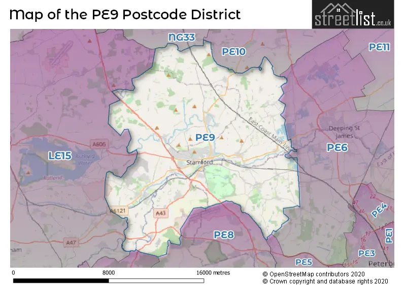
Map of the PE9 Postcode District
Explore the postcode district by using our interactive map.
Circles represent recorded crime; the larger the circle, the higher the crime rates.
Your support helps keep this site running!
If you enjoy using this website, consider buying me a coffee to help cover hosting costs.
Where is the PE9 District?
To give you an idea where the district is located we have created the following table showing nearby towns.
Nearest Towns to PE9
| Town | Distance (miles) | Direction |
|---|---|---|
| Market Deeping | 6.83 | E |
| Bourne | 8.42 | NNE |
| Oakham | 10.57 | W |
| Uppingham | 11.51 | WSW |
| Peterborough | 11.77 | ESE |
| Oundle | 12.62 | S |
| Crowland | 13.08 | E |
| Corby | 15.34 | SW |
| Spalding | 16.18 | ENE |
| Whittlesey | 16.54 | ESE |
| Grantham | 18.51 | NNW |
| Thrapston | 18.59 | S |
| Melton Mowbray | 18.60 | WNW |
| Kettering | 21.03 | SSW |
| Desborough | 21.04 | SW |
| Ramsey | 21.63 | SE |
| Raunds | 22.09 | S |
| Burton Latimer | 22.43 | SSW |
| Market Harborough | 22.61 | SW |
The post town for this district is STAMFORD.
Postcode Information for District PE9 (Total Geographical Postcodes: 1064)
| Location | Post Town | Sector | Number of Postcodes |
|---|---|---|---|
| STAMFORD | STAMFORD | PE9 2 | 359 |
| STAMFORD | STAMFORD | PE9 1 | 232 |
| Ketton | STAMFORD | PE9 3 | 62 |
| Ryhall | STAMFORD | PE9 4 | 44 |
| Barnack | STAMFORD | PE9 3 | 33 |
| Easton On The Hill | STAMFORD | PE9 3 | 32 |
| STAMFORD | STAMFORD | PE9 3 | 29 |
| Great Casterton | STAMFORD | PE9 4 | 25 |
| St. Martins | STAMFORD | PE9 2 | 22 |
| Collyweston | STAMFORD | PE9 3 | 21 |
| Uffington | STAMFORD | PE9 4 | 19 |
| Essendine | STAMFORD | PE9 4 | 17 |
| STAMFORD | STAMFORD | PE9 4 | 15 |
| Tallington | STAMFORD | PE9 4 | 14 |
| Carlby | STAMFORD | PE9 4 | 13 |
| Tinwell | STAMFORD | PE9 3 | 12 |
| Bainton | STAMFORD | PE9 3 | 12 |
| Greatford | STAMFORD | PE9 4 | 12 |
| Ufford | STAMFORD | PE9 3 | 9 |
| Duddington | STAMFORD | PE9 3 | 9 |
| Braceborough | STAMFORD | PE9 4 | 8 |
| Wothorpe | STAMFORD | PE9 3 | 8 |
| Belmesthorpe | STAMFORD | PE9 4 | 7 |
| Barholm | STAMFORD | PE9 4 | 6 |
| Pilsgate | STAMFORD | PE9 3 | 6 |
| Tixover | STAMFORD | PE9 3 | 4 |
| Little Casterton | STAMFORD | PE9 4 | 4 |
| Tickencote | STAMFORD | PE9 4 | 4 |
| Pickworth | STAMFORD | PE9 4 | 4 |
| Wilsthorpe | STAMFORD | PE9 4 | 3 |
| Holywell | STAMFORD | PE9 4 | 3 |
| Newstead | STAMFORD | PE9 4 | 3 |
| Southorpe | STAMFORD | PE9 3 | 3 |
| Aunby | STAMFORD | PE9 4 | 2 |
| Ashton | STAMFORD | PE9 3 | 2 |
| Careby | STAMFORD | PE9 4 | 2 |
| Tolethorpe | STAMFORD | PE9 4 | 2 |
| Uffington | STAMFORD | PE9 3 | 1 |
| Casewick | STAMFORD | PE9 4 | 1 |
Retail and Shopping in PE9
Street
Town
Locality
Number of Shops
Central Postcode
View on Google Maps
HIGH STREET
STAMFORD
67
PE9 2AL
View on Google Maps
ST MARYS STREET
STAMFORD
37
PE9 2DE
View on Google Maps
BROAD STREET
STAMFORD
26
PE9 1PX
View on Google Maps
ST MARYS HILL
STAMFORD
23
PE9 2DP
View on Google Maps
ST PAULS STREET
STAMFORD
18
PE9 2BE
View on Google Maps
SCOTGATE
STAMFORD
15
PE9 2YQ
View on Google Maps
IRONMONGER STREET
STAMFORD
13
PE9 1PL
View on Google Maps
RYHALL ROAD
STAMFORD
13
PE9 1XT
View on Google Maps
STAMFORD WALK
STAMFORD
13
PE9 2JE
View on Google Maps
NORTH STREET
STAMFORD
11
PE9 1EL
View on Google Maps
RED LION SQUARE
STAMFORD
11
PE9 2AH
View on Google Maps
RED LION STREET
STAMFORD
9
PE9 1PA
View on Google Maps
SILVER LANE
STAMFORD
9
PE9 2BT
View on Google Maps
ST JOHNS STREET
STAMFORD
8
PE9 2DB
View on Google Maps
HIGH STREET
STAMFORD
ST MARTINS
6
PE9 2LF
View on Google Maps
MAIDEN LANE
STAMFORD
6
PE9 2AZ
View on Google Maps
WEST STREET
STAMFORD
6
PE9 2PR
View on Google Maps
| Street | Town | Locality | Number of Shops | Central Postcode | View on Google Maps |
|---|---|---|---|---|---|
| HIGH STREET | STAMFORD | 67 | PE9 2AL | View on Google Maps | |
| ST MARYS STREET | STAMFORD | 37 | PE9 2DE | View on Google Maps | |
| BROAD STREET | STAMFORD | 26 | PE9 1PX | View on Google Maps | |
| ST MARYS HILL | STAMFORD | 23 | PE9 2DP | View on Google Maps | |
| ST PAULS STREET | STAMFORD | 18 | PE9 2BE | View on Google Maps | |
| SCOTGATE | STAMFORD | 15 | PE9 2YQ | View on Google Maps | |
| IRONMONGER STREET | STAMFORD | 13 | PE9 1PL | View on Google Maps | |
| RYHALL ROAD | STAMFORD | 13 | PE9 1XT | View on Google Maps | |
| STAMFORD WALK | STAMFORD | 13 | PE9 2JE | View on Google Maps | |
| NORTH STREET | STAMFORD | 11 | PE9 1EL | View on Google Maps | |
| RED LION SQUARE | STAMFORD | 11 | PE9 2AH | View on Google Maps | |
| RED LION STREET | STAMFORD | 9 | PE9 1PA | View on Google Maps | |
| SILVER LANE | STAMFORD | 9 | PE9 2BT | View on Google Maps | |
| ST JOHNS STREET | STAMFORD | 8 | PE9 2DB | View on Google Maps | |
| HIGH STREET | STAMFORD | ST MARTINS | 6 | PE9 2LF | View on Google Maps |
| MAIDEN LANE | STAMFORD | 6 | PE9 2AZ | View on Google Maps | |
| WEST STREET | STAMFORD | 6 | PE9 2PR | View on Google Maps |
The primary settlement in the PE9 postcode district is Stamford, located in both Cambridgeshire and Lincolnshire counties. Other significant settlements in this district include St. Martins, Ashton, Bainton, Barnack, Collyweston, Duddington, Easton On The Hill, Ketton, Pilsgate, Southorpe, Tinwell, Tixover, Uffington, Ufford, and Wothorpe. The most significant post town in this district is Stamford.
When it comes to local government, postal geography often disregards political borders. However, this district intersects the following councils: the district mostly encompasses the South Kesteven District (686 postal codes), followed by the Rutland area (186 postal codes), followed by the City of Peterborough (B) area (92 postal codes), and finally, the North Northamptonshire area (62 postal codes).
The largest settlement in the PE9 postal code is STAMFORD followed by Ketton, and Tallington.
The PE9 Postcode shares a border with LE15 (OAKHAM, Uppingham, Barleythorpe), PE6 (Market Deeping, Deeping St. James, Crowland), PE8 (Oundle, Wittering, Kings Cliffe), NG33 (Colsterworth, South Witham, Corby Glen), NN17 (CORBY, Weldon, Gretton) and PE10 (BOURNE, Morton, Thurlby).


Dentists in the PE9 District
| # | Name | Address | Type | Contact |
|---|---|---|---|---|
| 1 | Mr M Saleem | 14 BROAD STREET , STAMFORD , LINCOLNSHIRE , PE9 1PG | GENERAL DENTAL PRACTICE | |
| 2 | Orme House | RYHALL ROAD , STAMFORD , LINCOLNSHIRE , PE9 1UF | GENERAL DENTAL PRACTICE | |
| 3 | Broad Street (dental Surgery) | 35-36 BROAD STREET , STAMFORD , LINCOLNSHIRE , PE9 1PJ | GENERAL DENTAL PRACTICE | |
| 4 | Miss S Rennie | 34A ST MARYS STREET , STAMFORD , LINCOLNSHIRE , PE9 2DS | GENERAL DENTAL PRACTICE | |
| 5 | Mr Ph Williams | 34A ST MARYS STREET , STAMFORD , LINCOLNSHIRE , PE9 2DS | GENERAL DENTAL PRACTICE |
Doctors in the PE9 District
| # | Name | Address | Type | Contact |
|---|---|---|---|---|
| 1 | Lakeside Healthcare Stamford | , RYHALL ROAD , STAMFORD , LINCOLNSHIRE , PE9 1YA | GP PRACTICE | |
| 2 | St Mary's Medical Centre | , STAMFORD , LINCOLNSHIRE , PE9 2DH | BRANCH SURGERY | |
| 3 | Sheepmarket Surgery - Covid Local Vaccination Service | , STAMFORD , PE9 1YA | BRANCH SURGERY |
Chemists in the PE9 District
| # | Name | Address | Type | Contact |
|---|---|---|---|---|
| 1 | Stamford Pharmacy | 6 ST. MARYS HILL , STAMFORD , PE9 2DP | PHARMACY | |
| 2 | Superdrug Pharmacy | 22-22A HIGH STREET , STAMFORD , LINCOLNSHIRE , PE9 2AY | PHARMACY | |
| 3 | Boots | 66 HIGH STREET , STAMFORD , LINCOLNSHIRE , PE9 2AW | PHARMACY | |
| 4 | Well | SHEEP MARKET SURGERY , RYHALL ROAD , STAMFORD , LINCOLNSHIRE , PE9 1YA | PHARMACY |
Opticians in the PE9 District
| # | Name | Address | Type | Contact |
|---|---|---|---|---|
| 1 | CHRISTINE PIRRIE OPTOMETRISTS | 7 - 8 MAIDEN LANE , STAMFORD , LINCOLNSHIRE , PE9 2AZ | OPTICAL SITE | |
| 2 | VISION EXPRESS (STAMFORD) | UNIT 3 , ST MICHAEL'S CHURCH , HIGH STREET , STAMFORD , LINCOLNSHIRE , PE9 2AW | OPTICAL SITE | |
| 3 | SCRIVENS OPTICIANS (STAMFORD) | 10 IRONMONGER STREET , STAMFORD , LINCOLNSHIRE , PE9 1PL | OPTICAL SITE | |
| 4 | SPECSAVERS (STAMFORD) | UNIT 1 , MORRISONS SUPERMARKETS PLC , UFFINGTON ROAD , STAMFORD , LINCOLNSHIRE , PE9 2FT | OPTICAL SITE | |
| 5 | BOOTS OPTICIANS (STAMFORD) | UNIT 2 , ST. MICHAELS CHURCH , HIGH STREET , STAMFORD , LINCOLNSHIRE , PE9 2AW | OPTICAL SITE | |
| 6 | THE STAMFORD EYE CLINIC | 32 ST. PETERS STREET , STAMFORD , LINCOLNSHIRE , PE9 2PF | OPTICAL SITE |
Schools in the Sector
The Bluecoat School, Stamford
Phase: Primary
Address: Green Lane , The Bluecoat School , Stamford
Postcode: PE9 1HE
Headteacher: Mr Ben Bloor (Headteacher)
Ofsted Rating: Outstanding
Stamford Welland Academy
Phase: Secondary
Address: Green Lane , Stamford Welland Academy , Stamford
Postcode: PE9 1HE
Headteacher: Mrs Victoria Lloyd (Principal)
Ofsted Rating: Good
The Bluecoat School
Phase: Primary
Address: Green Lane , The Bluecoat School , Stamford
Postcode: PE9 1HE
Headteacher: Mrs Emma Houlton (Headteacher)
Ofsted Rating: Requires improvement
St Augustine's Catholic Voluntary Academy
Phase: Primary
Address: Kesteven Road , Stamford
Postcode: PE9 1SR
Headteacher: Mrs Tina Cox (Head of School)
Ofsted Rating: Requires improvement
St George's Church of England Aided Primary School
Phase: Primary
Address: Kesteven Road , Stamford
Postcode: PE9 1SX
Headteacher: Mrs Laura Martin (Executive Headteacher)
Ofsted Rating: Good
Stamford College (part of Inspire Education Group)
Phase: 16 plus
Address: Drift Road , Stamford
Postcode: PE9 1XA
Headteacher: Mrs Janet Meenaghan (Principal)
Ofsted Rating: Good
Stamford St Gilberts Church of England Primary School
Phase: Primary
Address: Foundry Road , Stamford
Postcode: PE9 2PP
Headteacher: Ms Frances Dicker (Headteacher)
Ofsted Rating: Good
Malcolm Sargent Primary School
Phase: Primary
Address: Empingham Road , Stamford
Postcode: PE9 2SR
Headteacher: Mr Tristan Revell (Principal)
Ofsted Rating: Good
Barnack CofE (Controlled) Primary School
Phase: Primary
Address: School Road , Barnack , Stamford
Postcode: PE9 3DZ
Headteacher: Mrs Colette Firth (Headteacher)
Ofsted Rating: Good
Easton Garford Endowed CofE School
Phase: Primary
Address: New Road , Easton-on-the-Hill , Stamford
Postcode: PE9 3NN
Headteacher: Mrs Jo Hodgson (Acting Headteacher)
Ofsted Rating: Requires improvement
Ketton CofE Primary School
Phase: Primary
Address: High Street , Ketton , Stamford
Postcode: PE9 3TE
Headteacher: Mr Rob Gooding (Executive Headteacher)
Ofsted Rating: Outstanding
Ketton Church of England Primary School
Phase: Primary
Address: Ketton Cof E Primary School High Street , Ketton , Stamford
Postcode: PE9 3TE
Headteacher: Mr Glenn Fraser (Headteacher)
Ofsted Rating: Good
Casterton College Rutland
Phase: Secondary
Address: Ryhall Road , Great Casterton , Stamford
Postcode: PE9 4AT
Headteacher: Carl Smith (Principal)
Ofsted Rating: Good
Great Casterton CofE Primary School
Phase: Primary
Address: Pickworth Road , Great Casterton , Stamford
Postcode: PE9 4AU
Headteacher: Mrs Sally Gooding (Headteacher)
Ofsted Rating: Outstanding
Great Casterton Church of England Primary School
Phase: Primary
Address: Pickworth Road , Great Casterton , Stamford
Postcode: PE9 4AU
Headteacher: Mrs Sally Gooding (Headteacher)
Ofsted Rating: Outstanding
Ryhall CofE Academy
Phase: Primary
Address: Church Street , Ryhall , Stamford
Postcode: PE9 4HR
Headteacher: Mr Alan Reed ()
Ofsted Rating: Good
The Uffington Church of England Primary School
Phase: Primary
Address: School Lane , Uffington , Stamford
Postcode: PE9 4SU
Headteacher: Mrs Helen Simms (Headteacher)
Ofsted Rating: Good
Stations in the Sector
Stamford (Lincs)
CRS Code: SMD
Operator: EM
Line: Birmingham to Peterborough Line
Company: East Midlands Railway
Accessable Motorway Junctions
A1(M) J17
Average Driving Time from within the district: 14.28
Average Driving Distance: 12.62
Number of Postcodes that can access the Motorway Junction: 1017
A1(M) J16
Average Driving Time from within the district: 16.56
Average Driving Distance: 15.03
Number of Postcodes that can access the Motorway Junction: 1017
A1(M) J15
Average Driving Time from within the district: 21.58
Average Driving Distance: 20.07
Number of Postcodes that can access the Motorway Junction: 1017
A1(M) J14
Average Driving Time from within the district: 25.81
Average Driving Distance: 24.26
Number of Postcodes that can access the Motorway Junction: 1017
A1(M) J13
Average Driving Time from within the district: 26.41
Average Driving Distance: 25.23
Number of Postcodes that can access the Motorway Junction: 1017
Weather Forecast for Stamford
| Time Period | Icon | Description | Temperature | Rain Probability | Wind |
|---|---|---|---|---|---|
| 00:00 to 03:00 | Cloudy | 8.0°C (feels like 5.0°C) | 8.00% | SW 13 mph | |
| 03:00 to 06:00 | Overcast | 8.0°C (feels like 5.0°C) | 9.00% | SW 11 mph | |
| 06:00 to 09:00 | Overcast | 8.0°C (feels like 5.0°C) | 9.00% | SW 13 mph | |
| 09:00 to 12:00 | Cloudy | 8.0°C (feels like 4.0°C) | 5.00% | SW 18 mph | |
| 12:00 to 15:00 | Cloudy | 10.0°C (feels like 7.0°C) | 9.00% | SW 20 mph | |
| 15:00 to 18:00 | Cloudy | 11.0°C (feels like 7.0°C) | 10.00% | SW 22 mph | |
| 18:00 to 21:00 | Cloudy | 11.0°C (feels like 7.0°C) | 36.00% | SW 25 mph | |
| 21:00 to 00:00 | Light rain | 10.0°C (feels like 7.0°C) | 77.00% | SW 22 mph |
| Time Period | Icon | Description | Temperature | Rain Probability | Wind |
|---|---|---|---|---|---|
| 00:00 to 03:00 | Cloudy | 11.0°C (feels like 7.0°C) | 20.00% | WSW 22 mph | |
| 03:00 to 06:00 | Cloudy | 10.0°C (feels like 7.0°C) | 54.00% | WSW 18 mph | |
| 06:00 to 09:00 | Light rain | 9.0°C (feels like 6.0°C) | 58.00% | WSW 11 mph | |
| 09:00 to 12:00 | Light rain | 9.0°C (feels like 6.0°C) | 54.00% | SW 13 mph | |
| 12:00 to 15:00 | Heavy rain | 9.0°C (feels like 6.0°C) | 89.00% | SSW 16 mph | |
| 15:00 to 18:00 | Heavy rain | 9.0°C (feels like 5.0°C) | 91.00% | SW 18 mph | |
| 18:00 to 21:00 | Heavy rain | 6.0°C (feels like 2.0°C) | 84.00% | WNW 18 mph | |
| 21:00 to 00:00 | Light rain | 4.0°C (feels like 0.0°C) | 59.00% | NW 13 mph |
| Time Period | Icon | Description | Temperature | Rain Probability | Wind |
|---|---|---|---|---|---|
| 00:00 to 03:00 | Partly cloudy (night) | 3.0°C (feels like -1.0°C) | 19.00% | NW 11 mph | |
| 03:00 to 06:00 | Clear night | 2.0°C (feels like -2.0°C) | 9.00% | NW 11 mph | |
| 06:00 to 09:00 | Clear night | 1.0°C (feels like -3.0°C) | 4.00% | NW 9 mph | |
| 09:00 to 12:00 | Sunny day | 0.0°C (feels like -4.0°C) | 3.00% | NW 9 mph | |
| 12:00 to 15:00 | Sunny day | 3.0°C (feels like -1.0°C) | 2.00% | NW 9 mph | |
| 15:00 to 18:00 | Sunny day | 2.0°C (feels like -1.0°C) | 3.00% | NW 9 mph | |
| 18:00 to 21:00 | Clear night | 0.0°C (feels like -4.0°C) | 1.00% | NW 9 mph | |
| 21:00 to 00:00 | Clear night | 0.0°C (feels like -4.0°C) | 1.00% | NW 9 mph |
| Time Period | Icon | Description | Temperature | Rain Probability | Wind |
|---|---|---|---|---|---|
| 00:00 to 03:00 | Clear night | -1.0°C (feels like -5.0°C) | 1.00% | NW 7 mph | |
| 03:00 to 06:00 | Clear night | -2.0°C (feels like -6.0°C) | 1.00% | NW 7 mph | |
| 06:00 to 09:00 | Clear night | -2.0°C (feels like -6.0°C) | 0.00% | WNW 7 mph | |
| 09:00 to 12:00 | Sunny day | -2.0°C (feels like -6.0°C) | 1.00% | WNW 7 mph | |
| 12:00 to 15:00 | Sunny day | 2.0°C (feels like -1.0°C) | 1.00% | W 9 mph | |
| 15:00 to 18:00 | Sunny day | 2.0°C (feels like -1.0°C) | 1.00% | W 9 mph | |
| 18:00 to 21:00 | Clear night | 1.0°C (feels like -3.0°C) | 2.00% | W 9 mph | |
| 21:00 to 00:00 | Clear night | 1.0°C (feels like -3.0°C) | 2.00% | W 9 mph |
| Postal Sector | Delivery Office |
|---|---|
| PE9 1 | Stamford Delivery Office |
| PE9 2 | Stamford Delivery Office |
| PE9 3 | Stamford Delivery Office |
| PE9 4 | Stamford Delivery Office |
| PE9 3 | Easton On The Hill Scale Payment Delivery Office |
| PE9 3 | Ketton Scale Payment Delivery Office |
| PE9 4 | Ryhall Scale Payment Delivery Office |
| P | E | 9 | - | X | X | X |
| P | E | 9 | Space | Numeric | Letter | Letter |
Street List for the PE9 District
Current Monthly Rental Prices
| # Bedrooms | Min Price | Max Price | Avg Price |
|---|---|---|---|
| £150 | £150 | £150 | |
| 1 | £110 | £1,100 | £676 |
| 2 | £795 | £1,255 | £986 |
| 3 | £900 | £3,900 | £1,407 |
| 4 | £1,450 | £2,500 | £1,891 |
| 5 | £2,200 | £4,200 | £3,200 |
Current House Prices
| # Bedrooms | Min Price | Max Price | Avg Price |
|---|---|---|---|
| £150,000 | £800,000 | £344,000 | |
| 1 | £94,950 | £475,000 | £172,161 |
| 2 | £65,000 | £540,000 | £236,625 |
| 3 | £130,000 | £1,095,000 | £365,874 |
| 4 | £170,000 | £1,375,000 | £604,165 |
| 5 | £425,000 | £2,500,000 | £1,018,333 |
| 6 | £635,000 | £1,800,000 | £1,196,000 |
| 7 | £2,600,000 | £2,950,000 | £2,833,333 |
| 8 | £1,350,000 | £1,350,000 | £1,350,000 |
Estate Agents
| Logo | Name | Brand Name | Address | Contact Number |
|---|---|---|---|---|
 | Stamford | Newton Fallowell | 4 Ironmonger Street, Stamford, PE9 1PL | 01780 432716 |
 | Stamford | Sowden Wallis Estate Agents | 8-9 Star Lane Stamford PE9 1PH | 01780 431524 |
 | Stamford | Goodwin Property Services | 2/3 St. Johns Street Stamford PE9 2DA | 01780 431636 |
 | Stamford | Hurfords | 38 St. Marys Street, Stamford, PE9 2DS | 01780 431573 |
 | Stamford | Knight Partnership | 3 Red Lion Street, Stamford, PE9 1PA | 01780 432732 |
Yearly House Price Averages for the District
| Type of Property | 2018 Average | 2018 Sales | 2017 Average | 2017 Sales | 2016 Average | 2016 Sales | 2015 Average | 2015 Sales |
|---|---|---|---|---|---|---|---|---|
| Detached | £459,740 | 247 | £437,333 | 263 | £443,029 | 213 | £389,389 | 218 |
| Semi-Detached | £283,159 | 192 | £258,970 | 189 | £245,931 | 194 | £231,467 | 160 |
| Terraced | £311,079 | 205 | £305,498 | 191 | £264,510 | 204 | £226,520 | 224 |
| Flats | £186,974 | 42 | £166,961 | 64 | £183,830 | 85 | £143,513 | 59 |