A wide range of spatial data has been analysed to present this overview of the OX27 7 Postcode sector. If you would like anything added, please contact us.
The OX27 7 postcode sector stands on the Oxfordshire and Northamptonshire border.
Did you know? According to the 2021 Census, the OX27 7 postcode sector is home to a bustling 2,197 residents!
Given that each sector allows for 400 unique postcode combinations. Letters C, I, K, M, O and V are not allowed in the last two letters of a postcode. With 115 postcodes already in use, this leaves 285 units available.
The largest settlement in the OX27 7 postal code is Fritwell followed by Ardley, and Souldern.
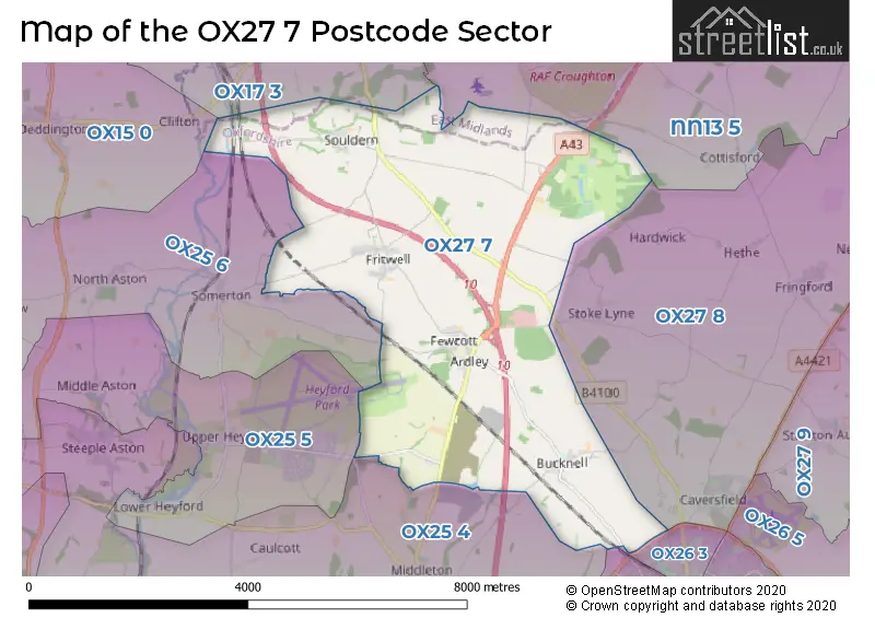
The OX27 7 Postcode shares a border with OX25 4 (Steeple Aston, Middleton Stoney, Caulcott), OX25 5 (Upper Heyford, Lower Heyford, Middle Aston), OX25 6 (Somerton, Duns Tew, North Aston), NN13 5 (Croughton, Helmdon, Syresham), OX15 0 (Deddington, Barford St. Michael, Hempton), OX17 3 (Adderbury, Kings Sutton, Twyford), OX26 2 (BICESTER), OX26 3 (BICESTER) and OX27 8 (BICESTER, Caversfield, Fringford).
Map of the OX27 7 Postcode Sector
Explore the OX27 7 postcode sector by using our interactive map.
The sector is within the post town of BICESTER.
OX27 7 is a postcode sector within the OX27 postcode district which is within the OX Oxford postcode area.
The Royal Mail delivery office for the OX27 7 postal sector is the Bicester Delivery Office.
The area of the OX27 7 postcode sector is 14.06 square miles which is 36.42 square kilometres or 8,998.61 square acres.
The OX27 7 postcode sector is crossed by the M40 motorway.
The OX27 7 postcode sector is crossed by the A43 Major A road.
Waterways within the OX27 7 postcode sector include the Oxford Canal.
Your support helps keep this site running!
If you enjoy using this website, consider buying me a coffee to help cover hosting costs.


| O | X | 2 | 7 | - | 7 | X | X |
| O | X | 2 | 7 | Space | 7 | Letter | Letter |
Official List of Streets
Ardley (15 Streets)
Bucknell (8 Streets)
Fewcott (4 Streets)
(11 Streets)
Souldern (11 Streets)
Fritwell (13 Streets)
Unofficial Streets or Alternative Spellings
BICESTER
BUCKNELL ROAD PURSLANE DRIVECaversfield
BANBURY ROADCroughton
PORTWAY ARDLEY ROUNDABOUT BAYNARDS GREEN FARM BAYNARDS GREEN ROUNDABOUT CHERWELL JUNCTION EXTON COTTAGES FOX HILL LANE HILL HOUSE LIME AVENUE PORT WAY STOKE LYNE WOODS YEW AVENUEUpper Heyford
CAMP ROADMiddleton Stoney
ARDLEY ROADWeather Forecast for OX27 7
Weather Forecast for Rousham House
| Time Period | Icon | Description | Temperature | Rain Probability | Wind |
|---|---|---|---|---|---|
| 09:00 to 12:00 | Overcast | 4.0°C (feels like 3.0°C) | 10.00% | S 4 mph | |
| 12:00 to 15:00 | Overcast | 7.0°C (feels like 5.0°C) | 52.00% | S 4 mph | |
| 15:00 to 18:00 | Cloudy | 8.0°C (feels like 6.0°C) | 9.00% | SSW 7 mph | |
| 18:00 to 21:00 | Cloudy | 5.0°C (feels like 3.0°C) | 4.00% | S 4 mph | |
| 21:00 to 00:00 | Cloudy | 5.0°C (feels like 2.0°C) | 5.00% | SSW 7 mph |
| Time Period | Icon | Description | Temperature | Rain Probability | Wind |
|---|---|---|---|---|---|
| 00:00 to 03:00 | Cloudy | 6.0°C (feels like 3.0°C) | 4.00% | SSW 9 mph | |
| 03:00 to 06:00 | Cloudy | 6.0°C (feels like 3.0°C) | 4.00% | SSW 11 mph | |
| 06:00 to 09:00 | Cloudy | 7.0°C (feels like 4.0°C) | 8.00% | SSW 11 mph | |
| 09:00 to 12:00 | Overcast | 8.0°C (feels like 5.0°C) | 9.00% | SSW 13 mph | |
| 12:00 to 15:00 | Cloudy | 10.0°C (feels like 7.0°C) | 13.00% | SSW 16 mph | |
| 15:00 to 18:00 | Light rain | 10.0°C (feels like 7.0°C) | 89.00% | SSW 16 mph | |
| 18:00 to 21:00 | Cloudy | 9.0°C (feels like 6.0°C) | 61.00% | WSW 11 mph | |
| 21:00 to 00:00 | Clear night | 7.0°C (feels like 4.0°C) | 3.00% | WSW 9 mph |
| Time Period | Icon | Description | Temperature | Rain Probability | Wind |
|---|---|---|---|---|---|
| 00:00 to 03:00 | Clear night | 5.0°C (feels like 2.0°C) | 0.00% | WSW 9 mph | |
| 03:00 to 06:00 | Clear night | 4.0°C (feels like 1.0°C) | 0.00% | WSW 9 mph | |
| 06:00 to 09:00 | Clear night | 3.0°C (feels like 0.0°C) | 1.00% | WSW 7 mph | |
| 09:00 to 12:00 | Cloudy | 4.0°C (feels like 1.0°C) | 4.00% | W 7 mph | |
| 12:00 to 15:00 | Cloudy | 7.0°C (feels like 5.0°C) | 5.00% | WNW 7 mph | |
| 15:00 to 18:00 | Cloudy | 8.0°C (feels like 6.0°C) | 5.00% | NW 7 mph | |
| 18:00 to 21:00 | Cloudy | 4.0°C (feels like 2.0°C) | 4.00% | NW 4 mph | |
| 21:00 to 00:00 | Partly cloudy (night) | 2.0°C (feels like 0.0°C) | 1.00% | NNW 4 mph |
| Time Period | Icon | Description | Temperature | Rain Probability | Wind |
|---|---|---|---|---|---|
| 00:00 to 03:00 | Clear night | 1.0°C (feels like -1.0°C) | 1.00% | N 4 mph | |
| 03:00 to 06:00 | Clear night | 0.0°C (feels like -2.0°C) | 1.00% | NE 4 mph | |
| 06:00 to 09:00 | Clear night | 0.0°C (feels like -3.0°C) | 1.00% | NE 4 mph | |
| 09:00 to 12:00 | Sunny day | 1.0°C (feels like -2.0°C) | 1.00% | ENE 7 mph | |
| 12:00 to 15:00 | Sunny day | 6.0°C (feels like 4.0°C) | 1.00% | ENE 7 mph | |
| 15:00 to 18:00 | Sunny day | 7.0°C (feels like 5.0°C) | 1.00% | ENE 9 mph | |
| 18:00 to 21:00 | Clear night | 4.0°C (feels like 1.0°C) | 1.00% | ENE 7 mph | |
| 21:00 to 00:00 | Clear night | 2.0°C (feels like -1.0°C) | 2.00% | ENE 7 mph |
| Time Period | Icon | Description | Temperature | Rain Probability | Wind |
|---|---|---|---|---|---|
| 00:00 to 03:00 | Clear night | 2.0°C (feels like -2.0°C) | 3.00% | NE 7 mph | |
| 03:00 to 06:00 | Mist | 2.0°C (feels like -2.0°C) | 13.00% | NE 9 mph | |
| 06:00 to 09:00 | Mist | 2.0°C (feels like -2.0°C) | 14.00% | NE 9 mph | |
| 09:00 to 12:00 | Overcast | 2.0°C (feels like -1.0°C) | 9.00% | NE 9 mph | |
| 12:00 to 15:00 | Partly cloudy (day) | 5.0°C (feels like 1.0°C) | 2.00% | ENE 11 mph | |
| 15:00 to 18:00 | Sunny day | 6.0°C (feels like 3.0°C) | 3.00% | NE 11 mph | |
| 18:00 to 21:00 | Clear night | 3.0°C (feels like 0.0°C) | 2.00% | NE 9 mph | |
| 21:00 to 00:00 | Clear night | 2.0°C (feels like -1.0°C) | 3.00% | NE 7 mph |
House Prices in the OX27 7 Postcode Sector
| Type of Property | 2018 Average | 2018 Sales | 2017 Average | 2017 Sales | 2016 Average | 2016 Sales | 2015 Average | 2015 Sales |
|---|---|---|---|---|---|---|---|---|
| Detached | £508,368 | 17 | £422,136 | 11 | £506,100 | 15 | £555,237 | 19 |
| Semi-Detached | £301,000 | 2 | £433,490 | 5 | £343,100 | 5 | £317,446 | 13 |
| Terraced | £277,420 | 10 | £365,000 | 7 | £307,167 | 6 | £389,369 | 8 |
| Flats | £158,143 | 7 | £140,000 | 1 | £150,000 | 1 | £171,000 | 1 |
Important Postcodes OX27 7 in the Postcode Sector
OX27 7PX is the postcode for Fritwell C of E School, East Street
| The OX27 7 Sector is within these Local Authorities |
|
|---|---|
| The OX27 7 Sector is within these Counties |
|
| The OX27 7 Sector is within these Water Company Areas |
|