A wide range of spatial data has been analysed to present this overview of the NW10 7 Postcode sector. If you would like anything added, please contact us.
The NW10 7 postcode sector is within the county of Greater London.
Did you know? According to the 2021 Census, the NW10 7 postcode sector is home to a bustling 5,985 residents!
Given that each sector allows for 400 unique postcode combinations. Letters C, I, K, M, O and V are not allowed in the last two letters of a postcode. With 192 postcodes already in use, this leaves 208 units available.
The largest settlements in the NW10 7 postal code are PARK ROYAL and LONDON .
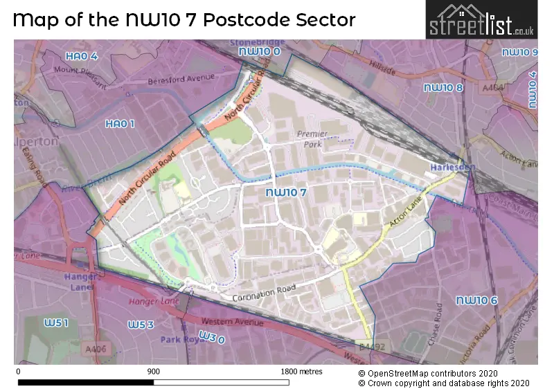
The NW10 7 Postcode shares a border with NW10 6 (PARK ROYAL , LONDON ), NW10 8 (LONDON , STONEBRIDGE ), W3 0 (ACTON ), W3 6 (ACTON ), W5 3 (EALING ), HA0 1 (WEMBLEY ), NW10 0 (LONDON , STONEBRIDGE , NEASDEN ) and W5 1 (EALING ).
Map of the NW10 7 Postcode Sector
Explore the NW10 7 postcode sector by using our interactive map.
The sector is within the post town of LONDON.
NW10 7 is a postcode sector within the NW10 postcode district which is within the NW North West London postcode area.
The Royal Mail delivery office for the NW10 7 postal sector is the Willesden Sdelivery Office.
The area of the NW10 7 postcode sector is 1.13 square miles which is 2.92 square kilometres or 720.64 square acres.
Waterways within the NW10 7 postcode sector include the Grand Union Canal (Paddington Branch), River Brent.
Your support helps keep this site running!
If you enjoy using this website, consider buying me a coffee to help cover hosting costs.


| N | W | 1 | 0 | - | 7 | X | X |
| N | W | 1 | 0 | Space | 7 | Letter | Letter |
Official List of Streets
Brent (22 Streets)
Ealing (32 Streets)
(11 Streets)
Unofficial Streets or Alternative Spellings
Barnet
NORTH CIRCULAR ROADEaling
CULLEN WAY GORST ROAD LYTHAM GROVE MINERVA ROAD PRIORY GARDENS STANDARD ROAD SUNBEAM ROAD WESTERN AVENUEWEMBLEY
ABBEYDALE ROAD BERESFORD AVENUE HEATHER PARK DRIVEWeather Forecast for NW10 7
Weather Forecast for Wembley Stadium
| Time Period | Icon | Description | Temperature | Rain Probability | Wind |
|---|---|---|---|---|---|
| 15:00 to 18:00 | Overcast | 7.0°C (feels like 5.0°C) | 9.00% | S 7 mph | |
| 18:00 to 21:00 | Cloudy | 6.0°C (feels like 3.0°C) | 5.00% | SSE 7 mph | |
| 21:00 to 00:00 | Partly cloudy (night) | 4.0°C (feels like 2.0°C) | 1.00% | SSE 7 mph |
| Time Period | Icon | Description | Temperature | Rain Probability | Wind |
|---|---|---|---|---|---|
| 00:00 to 03:00 | Partly cloudy (night) | 4.0°C (feels like 1.0°C) | 1.00% | SSE 4 mph | |
| 03:00 to 06:00 | Partly cloudy (night) | 3.0°C (feels like 1.0°C) | 0.00% | SSE 4 mph | |
| 06:00 to 09:00 | Clear night | 2.0°C (feels like 0.0°C) | 0.00% | SE 4 mph | |
| 09:00 to 12:00 | Sunny day | 3.0°C (feels like 1.0°C) | 0.00% | SE 4 mph | |
| 12:00 to 15:00 | Sunny day | 6.0°C (feels like 4.0°C) | 0.00% | SSE 4 mph | |
| 15:00 to 18:00 | Sunny day | 7.0°C (feels like 5.0°C) | 0.00% | S 4 mph | |
| 18:00 to 21:00 | Clear night | 5.0°C (feels like 3.0°C) | 1.00% | S 4 mph | |
| 21:00 to 00:00 | Clear night | 3.0°C (feels like 2.0°C) | 1.00% | S 4 mph |
| Time Period | Icon | Description | Temperature | Rain Probability | Wind |
|---|---|---|---|---|---|
| 00:00 to 03:00 | Clear night | 2.0°C (feels like 0.0°C) | 2.00% | SSW 4 mph | |
| 03:00 to 06:00 | Cloudy | 1.0°C (feels like -1.0°C) | 5.00% | SSW 4 mph | |
| 06:00 to 09:00 | Overcast | 1.0°C (feels like -1.0°C) | 9.00% | SSW 4 mph | |
| 09:00 to 12:00 | Overcast | 3.0°C (feels like 1.0°C) | 9.00% | SSW 4 mph | |
| 12:00 to 15:00 | Overcast | 6.0°C (feels like 4.0°C) | 8.00% | SSW 4 mph | |
| 15:00 to 18:00 | Sunny day | 8.0°C (feels like 6.0°C) | 2.00% | SSW 7 mph | |
| 18:00 to 21:00 | Partly cloudy (night) | 6.0°C (feels like 4.0°C) | 2.00% | SSW 7 mph | |
| 21:00 to 00:00 | Partly cloudy (night) | 5.0°C (feels like 2.0°C) | 2.00% | SSW 7 mph |
| Time Period | Icon | Description | Temperature | Rain Probability | Wind |
|---|---|---|---|---|---|
| 00:00 to 03:00 | Cloudy | 4.0°C (feels like 2.0°C) | 5.00% | SSW 7 mph | |
| 03:00 to 06:00 | Clear night | 5.0°C (feels like 2.0°C) | 3.00% | S 7 mph | |
| 06:00 to 09:00 | Partly cloudy (night) | 5.0°C (feels like 2.0°C) | 3.00% | SSW 7 mph | |
| 09:00 to 12:00 | Cloudy | 6.0°C (feels like 3.0°C) | 5.00% | SSW 9 mph | |
| 12:00 to 15:00 | Cloudy | 9.0°C (feels like 6.0°C) | 6.00% | SSW 11 mph | |
| 15:00 to 18:00 | Cloudy | 10.0°C (feels like 7.0°C) | 10.00% | SSW 11 mph | |
| 18:00 to 21:00 | Overcast | 9.0°C (feels like 6.0°C) | 20.00% | SSW 9 mph | |
| 21:00 to 00:00 | Light rain | 8.0°C (feels like 6.0°C) | 45.00% | SW 7 mph |
| Time Period | Icon | Description | Temperature | Rain Probability | Wind |
|---|---|---|---|---|---|
| 00:00 to 03:00 | Clear night | 7.0°C (feels like 5.0°C) | 7.00% | WSW 7 mph | |
| 03:00 to 06:00 | Clear night | 5.0°C (feels like 4.0°C) | 5.00% | W 4 mph | |
| 06:00 to 09:00 | Clear night | 4.0°C (feels like 2.0°C) | 2.00% | WNW 4 mph | |
| 09:00 to 12:00 | Partly cloudy (day) | 4.0°C (feels like 2.0°C) | 2.00% | NW 4 mph | |
| 12:00 to 15:00 | Cloudy | 7.0°C (feels like 6.0°C) | 4.00% | NW 4 mph | |
| 15:00 to 18:00 | Cloudy | 8.0°C (feels like 7.0°C) | 5.00% | N 4 mph | |
| 18:00 to 21:00 | Cloudy | 7.0°C (feels like 6.0°C) | 5.00% | N 4 mph | |
| 21:00 to 00:00 | Cloudy | 5.0°C (feels like 4.0°C) | 5.00% | N 4 mph |
Schools and Places of Education Within the NW10 7 Postcode Sector
Advance Education
Other independent school
Unit 5 Unimix House, London, , NW10 7TR
Head: Mrs Suzan Polat
Ofsted Rating: Inadequate
Inspection: 2022-11-03 (821 days ago)
Website: Visit Advance Education Website
Phone: 02088383922
Number of Pupils: 140
West Twyford Primary School
Community school
Twyford Abbey Road, London, , NW10 7DN
Head: Mr Matthew Shapland
Ofsted Rating: Good
Inspection: 2023-09-13 (507 days ago)
Website: Visit West Twyford Primary School Website
Phone: 02089656858
Number of Pupils: 454
House Prices in the NW10 7 Postcode Sector
| Type of Property | 2018 Average | 2018 Sales | 2017 Average | 2017 Sales | 2016 Average | 2016 Sales | 2015 Average | 2015 Sales |
|---|---|---|---|---|---|---|---|---|
| Detached | £0 | 0 | £760,000 | 1 | £0 | 0 | £0 | 0 |
| Semi-Detached | £468,125 | 4 | £523,750 | 4 | £460,667 | 3 | £526,297 | 6 |
| Terraced | £494,889 | 9 | £541,292 | 12 | £470,417 | 6 | £422,500 | 12 |
| Flats | £212,707 | 58 | £446,854 | 85 | £404,054 | 229 | £367,078 | 162 |
Important Postcodes NW10 7 in the Postcode Sector
NW10 7DN is the postcode for West Twyford Primary School, Twyford Abbey Road, and WEST TWYFORD PRIMARY SCHOOL, TWYFORD ABBEY ROAD, PARK ROYAL
NW10 7NS is the postcode for AMBULATORY CARE AND DIAGNOSTIC CENTRE CENTRAL MIDDLESEX HOSPITAL, Central Middlesex Hospital, Acton Lane, Central and North West London NHS Foundation Trust, Park Royal Centre For Mental Health, BRENT EMERGENCY CARE AND DIAGNOSTIC CENTRE CENTRAL MIDDLESEX HOSPITAL, Central Middlesex Hospital, Acton Lane, Park Royal Centre for Mental Health Intensive Care Unit, Central Way, North West London Hospitals NHS Trust, Central Middlesex Hospital, Park Royal Centre for Mental Health Coombe Wood, Central Way, and Park Royal Centre for Mental Health Mental Health Unit, Central Way
NW10 7NU is the postcode for Park Royal Fire Station, 15 Waxlow Road
NW10 7NZ is the postcode for Royal Mail Delivery Centre, Unit 20-23, and Royal Mail, Unit 20-23 West London Delivery Office, 7 Premier Park Road
NW10 7RH is the postcode for Royal Mail, Princess Royal Distribution Centre, Blackmore Drive, North Circular Road
NW10 7XT is the postcode for Unit 1 Nucleus, Central Way
| The NW10 7 Sector is within these Local Authorities |
|
|---|---|
| The NW10 7 Sector is within these Counties |
|
| The NW10 7 Sector is within these Water Company Areas |
|