A wide range of spatial data has been analysed to present this overview of the NR11 8 Postcode sector. If you would like anything added, please contact us.
The NR11 8 postcode sector is within the county of Norfolk.
Did you know? According to the 2021 Census, the NR11 8 postcode sector is home to a bustling 6,903 residents!
Given that each sector allows for 400 unique postcode combinations. Letters C, I, K, M, O and V are not allowed in the last two letters of a postcode. With 268 postcodes already in use, this leaves 132 units available.
The largest settlement in the NR11 8 postal code is Mundesley followed by Southrepps, and Roughton.
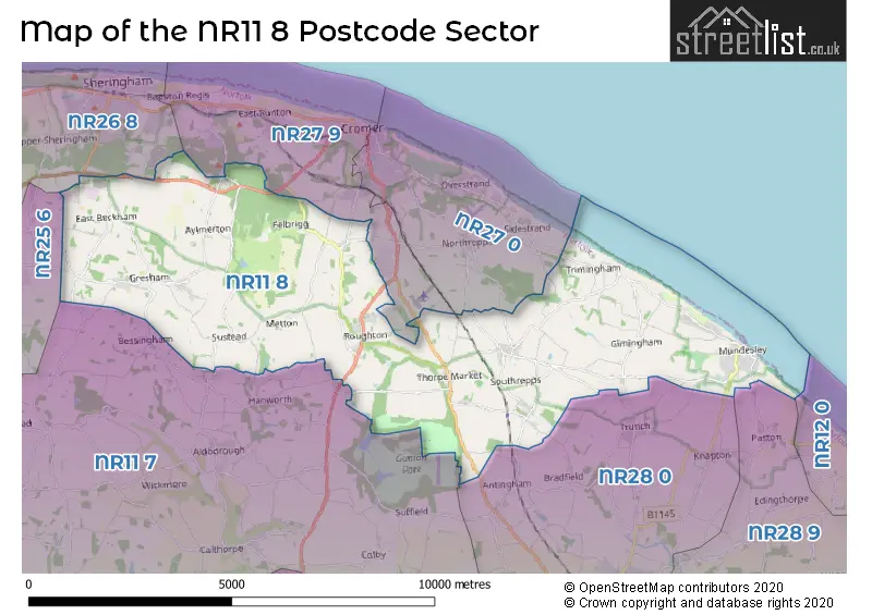
The NR11 8 Postcode shares a border with NR11 7 (Erpingham, Aldborough, Hanworth), NR25 6 (HOLT, High Kelling, Bodham), NR26 8 (SHERINGHAM, Beeston Regis, Upper Sheringham), NR27 0 (CROMER, Overstrand, Northrepps), NR27 9 (CROMER, West Runton, East Runton), NR12 0 (Bacton, Hickling, Happisburgh), NR28 0 (NORTH WALSHAM, Trunch, Felmingham) and NR28 9 (NORTH WALSHAM, Worstead, Dilham).
Map of the NR11 8 Postcode Sector
Explore the NR11 8 postcode sector by using our interactive map.
The sector is within the post town of NORWICH.
NR11 8 is a postcode sector within the NR11 postcode district which is within the NR Norwich postcode area.
The Royal Mail delivery office for the NR11 8 postal sector is the Sheringham Delivery Office and Mundesley Scale Payment Delivery Office.
The area of the NR11 8 postcode sector is 23.32 square miles which is 60.39 square kilometres or 14,922.78 square acres.
Your support helps keep this site running!
If you enjoy using this website, consider buying me a coffee to help cover hosting costs.


| N | R | 1 | 1 | - | 8 | X | X |
| N | R | 1 | 1 | Space | 8 | Letter | Letter |
Official List of Streets
Mundesley (64 Streets)
Southrepps (25 Streets)
Sustead (3 Streets)
Roughton (18 Streets)
Gimingham (16 Streets)
Gresham (10 Streets)
Trimingham (12 Streets)
(37 Streets)
Aylmerton (8 Streets)
Thorpe Market (8 Streets)
Felbrigg (7 Streets)
Lower Gresham (3 Streets)
East Beckham (2 Streets)
Metton (1 Streets)
Unofficial Streets or Alternative Spellings
Mundesley
WATSON-WATT GARDENSAntingham
CROMER ROAD ELDERTON LANE SOUTHREPPS ROADTrunch
BRICK KILN ROADHanworth
NORWICH ROADSidestrand
CROMER ROADNorthrepps
CRAFT LANE NORTH WALSHAM ROADCROMER
HALL ROAD ROUGHTON ROADWest Beckham
CHURCH ROADWeather Forecast for NR11 8
Weather Forecast for Mundesley
Schools and Places of Education Within the NR11 8 Postcode Sector
Antingham and Southrepps Primary School
Academy sponsor led
Lower Street, Norwich, Norfolk, NR11 8UG
Head: Mr Miles Elcock
Ofsted Rating: Good
Inspection: 2023-03-10 (694 days ago)
Website: Visit Antingham and Southrepps Primary School Website
Phone: 01263833282
Number of Pupils: 58
Gresham Village School
Academy converter
Cromer Road, Norwich, Norfolk, NR11 8RF
Head: Mr Marc Goodliffe
Ofsted Rating: Good
Inspection: 2022-02-08 (1089 days ago)
Website: Visit Gresham Village School Website
Phone: 01263577349
Number of Pupils: 178
Mundesley Infant School
Community school
Trunch Road, Norwich, Norfolk, NR11 8LE
Head: Mrs Abigale Carter
Ofsted Rating: Good
Inspection: 2018-12-05 (2250 days ago)
Website: Visit Mundesley Infant School Website
Phone: 01263720401
Number of Pupils: 74
Mundesley Junior School
Community school
Trunch Road, Norwich, Norfolk, NR11 8LE
Head: Mrs Abi Carter
Ofsted Rating: Good
Inspection: 2023-03-14 (690 days ago)
Website: Visit Mundesley Junior School Website
Phone: 01263720401
Number of Pupils: 109
St Andrew's School
Other independent special school
Aylmerton Hall, Cromer, Norfolk, NR11 8QA
Head: Julie Jackson Jim Collin
Ofsted Rating: Good
Inspection: 2023-03-16 (688 days ago)
Website: Visit St Andrew's School Website
Phone: 01263837927
Number of Pupils: 45
St. Mary's (Endowed) CofE VA Primary School
Voluntary aided school
Chapel Road, Norwich, Norfolk, NR11 8AF
Head: Mrs Laura Watts
Ofsted Rating: Good
Inspection: 2018-06-27 (2411 days ago)
Website: Visit St. Mary's (Endowed) CofE VA Primary School Website
Phone: 01263761368
Number of Pupils: 89
House Prices in the NR11 8 Postcode Sector
| Type of Property | 2018 Average | 2018 Sales | 2017 Average | 2017 Sales | 2016 Average | 2016 Sales | 2015 Average | 2015 Sales |
|---|---|---|---|---|---|---|---|---|
| Detached | £335,044 | 65 | £320,271 | 77 | £299,425 | 83 | £281,433 | 76 |
| Semi-Detached | £251,646 | 35 | £234,266 | 32 | £204,949 | 38 | £185,288 | 29 |
| Terraced | £212,588 | 26 | £221,124 | 22 | £195,732 | 25 | £186,495 | 29 |
| Flats | £83,063 | 4 | £89,200 | 5 | £97,571 | 7 | £83,571 | 7 |
Important Postcodes NR11 8 in the Postcode Sector
NR11 8AR is the postcode for Munhaven, Munhaven Close, and Munhaven, Munhaven Close, Mundesley
NR11 8LE is the postcode for MAIN BLOCK, Mundesley First School, Trunch Road, and Mundesley Junior School, Trunch Road
NR11 8RF is the postcode for MAIN BUILDING, Gresham Village School And Nursery, Cromer Road
NR11 8UG is the postcode for Antingham & Southrepps Community Primary School, Southrepps
| The NR11 8 Sector is within these Local Authorities |
|
|---|---|
| The NR11 8 Sector is within these Counties |
|
| The NR11 8 Sector is within these Water Company Areas |
|
Tourist Attractions within the NR11 8 Postcode Area
We found 1 visitor attractions within the NR11 postcode area
| Felbrigg Hall, Garden and Park |
|---|
| Historic Properties |
| Historic House / House and Garden / Palace |
| View Felbrigg Hall, Garden and Park on Google Maps |