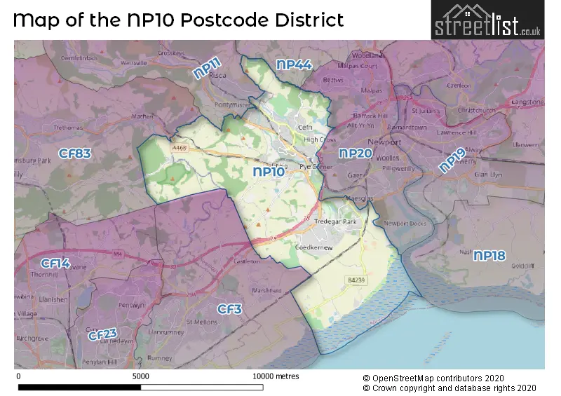
Map of the NP10 Postcode District
Explore the postcode district by using our interactive map.
Circles represent recorded crime; the larger the circle, the higher the crime rates.
Your support helps keep this site running!
If you enjoy using this website, consider buying me a coffee to help cover hosting costs.
Where is the NP10 District?
To give you an idea where the district is located we have created the following table showing nearby towns.
Nearest Towns to NP10
| Town | Distance (miles) | Direction |
|---|---|---|
| Newport | 3.00 | ENE |
| Risca | 3.64 | NNW |
| Caerleon | 5.29 | ENE |
| Cwmbr�n | 6.13 | NNE |
| Abercarn | 6.32 | NNW |
| Caerphilly | 6.83 | W |
| Newbridge | 7.59 | NNW |
| Pontllanfraith | 8.09 | NW |
| Blackwood | 9.01 | NW |
| Ystrad Mynach | 9.11 | WNW |
| Pontypool | 9.19 | N |
| Penarth | 10.40 | SSW |
| Bargod | 11.18 | NW |
| Usk | 11.36 | NE |
| Abersychan | 11.54 | N |
| Abertillery | 11.61 | NNW |
| Pontypridd | 12.39 | W |
| Treharris | 12.42 | WNW |
| Abercynon | 12.76 | WNW |
| Clevedon | 12.80 | SE |
The post town for this district is NEWPORT.
Postcode Information for District NP10 (Total Geographical Postcodes: 665)
| Location | Post Town | Sector | Number of Postcodes |
|---|---|---|---|
| Rogerstone | NEWPORT | NP10 9 | 242 |
| Bassaleg | NEWPORT | NP10 8 | 120 |
| NEWPORT | NEWPORT | NP10 8 | 89 |
| Coedkernew | NEWPORT | NP10 8 | 52 |
| Duffryn | NEWPORT | NP10 8 | 50 |
| Rogerstone | NEWPORT | NP10 0 | 44 |
| Rhiwderin | NEWPORT | NP10 8 | 28 |
| St. Brides Wentlooge | NEWPORT | NP10 8 | 21 |
| Draethen | NEWPORT | NP10 8 | 8 |
| Lower Machen | NEWPORT | NP10 8 | 6 |
| NEWPORT | NEWPORT | NP10 9 | 4 |
| Celtic Lakes | NEWPORT | NP10 8 | 1 |
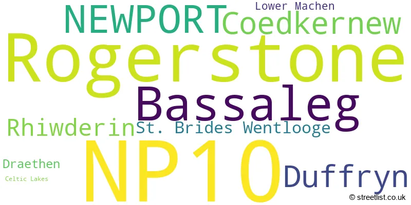
The primary settlement in the NP10 postcode district is Rogerstone, located in the county of Gwent, Wales. In addition, there are other significant settlements in the district, including Bassaleg, Celtic Lakes, Coedkernew, Draethen, Duffryn, Lower Machen, Rhiwderin, and St. Brides Wentlooge. These settlements are all part of the post town of Newport.
When it comes to local government, postal geography often disregards political borders. However, this district intersects the following councils: the district mostly encompasses the Casnewydd - Newport (575 postal codes), and finally, the Caerffili - Caerphilly area (15 postal codes).
The largest settlement in the NP10 postal code is ROGERSTONE followed by NEWPORT, and BASSALEG.
The postcode area has a boundary with The Bristol Channel.
The NP10 Postcode shares a border with CF83 (CAERPHILLY, BEDWAS, LLANBRADACH), NP11 (PONTYMISTER, NEWBRIDGE, ABERCARN), NP44 (CWMBRAN, Pontnewydd, CROESYCEILIOG), NP19 (NEWPORT, LLANWERN) and CF3 (TROWBRIDGE, LLANRUMNEY, RUMNEY).


Dentists in the NP10 District
| # | Name | Address | Type | Contact |
|---|---|---|---|---|
| 1 | Coach House Dental Surgery | 6A CAERPHILLY ROAD , BASSALEG , NEWPORT , GWENT , NP10 8LE | GENERAL DENTAL PRACTICE |
Doctors in the NP10 District
| # | Name | Address | Type | Contact |
|---|---|---|---|---|
| 1 | The Rogerstone Practice | , WESTERN VALLEY ROAD , ROGERSTONE , NEWPORT , GWENT , NP10 9DU | GP PRACTICE |
Chemists in the NP10 District
| # | Name | Address | Type | Contact |
|---|---|---|---|---|
| 1 | Asda Pharmacy | PENCARN WAY , DUFFRYN , NEWPORT , NP10 8XL | PHARMACY | |
| 2 | Bassaleg Pharmacy | 9 ST. BASILS STORES , BASSALEG , NEWPORT , NP10 8NN | PHARMACY | |
| 3 | Well | THE ROGERSTONE PRACTICE , CHAPELWOOD PRIMARY CARE CENTRE , WESTERN VALLEY ROAD, ROGERSTONE , NEWPORT , NP10 9DU | PHARMACY |
Opticians in the NP10 District
No Opticians found in this district.
Stations in the Sector
Pye Corner
CRS Code: PYE
Operator: AW
Line: Ebbw Valley Railway
Company: Transport for Wales
Rogerstone
CRS Code: ROR
Operator: AW
Line: Ebbw Valley Railway
Company: Transport for Wales
Accessable Motorway Junctions
M4 J28
Average Driving Time from within the district: 3.53
Average Driving Distance: 2.02
Number of Postcodes that can access the Motorway Junction: 584
M4 J27
Average Driving Time from within the district: 3.78
Average Driving Distance: 2.02
Number of Postcodes that can access the Motorway Junction: 584
M4 J26
Average Driving Time from within the district: 6.37
Average Driving Distance: 3.99
Number of Postcodes that can access the Motorway Junction: 548
M4 J25
Average Driving Time from within the district: 7.07
Average Driving Distance: 4.16
Number of Postcodes that can access the Motorway Junction: 66
M4 J25A
Average Driving Time from within the district: 8.27
Average Driving Distance: 4.57
Number of Postcodes that can access the Motorway Junction: 477
M4 J30
Average Driving Time from within the district: 8.85
Average Driving Distance: 5.96
Number of Postcodes that can access the Motorway Junction: 61
Weather Forecast for Tredegar House Newport
| Time Period | Icon | Description | Temperature | Rain Probability | Wind |
|---|---|---|---|---|---|
| 00:00 to 03:00 | Cloudy | 3.0°C (feels like 0.0°C) | 8.00% | ENE 7 mph | |
| 03:00 to 06:00 | Overcast | 3.0°C (feels like 0.0°C) | 11.00% | ENE 9 mph | |
| 06:00 to 09:00 | Overcast | 3.0°C (feels like -1.0°C) | 14.00% | ENE 9 mph | |
| 09:00 to 12:00 | Overcast | 3.0°C (feels like -1.0°C) | 15.00% | NE 9 mph | |
| 12:00 to 15:00 | Overcast | 4.0°C (feels like 1.0°C) | 16.00% | NE 9 mph | |
| 15:00 to 18:00 | Cloudy | 5.0°C (feels like 2.0°C) | 14.00% | NE 9 mph | |
| 18:00 to 21:00 | Overcast | 4.0°C (feels like 2.0°C) | 17.00% | NE 7 mph | |
| 21:00 to 00:00 | Overcast | 4.0°C (feels like 1.0°C) | 18.00% | NNE 7 mph |
| Time Period | Icon | Description | Temperature | Rain Probability | Wind |
|---|---|---|---|---|---|
| 00:00 to 03:00 | Cloudy | 3.0°C (feels like 1.0°C) | 19.00% | N 7 mph | |
| 03:00 to 06:00 | Cloudy | 3.0°C (feels like 1.0°C) | 17.00% | NW 7 mph | |
| 06:00 to 09:00 | Overcast | 3.0°C (feels like 1.0°C) | 16.00% | WNW 7 mph | |
| 09:00 to 12:00 | Cloudy | 4.0°C (feels like 2.0°C) | 13.00% | S 7 mph | |
| 12:00 to 15:00 | Cloudy | 6.0°C (feels like 4.0°C) | 13.00% | SW 9 mph | |
| 15:00 to 18:00 | Cloudy | 7.0°C (feels like 5.0°C) | 11.00% | SW 9 mph | |
| 18:00 to 21:00 | Light rain | 6.0°C (feels like 3.0°C) | 44.00% | SW 9 mph | |
| 21:00 to 00:00 | Cloudy | 5.0°C (feels like 3.0°C) | 14.00% | SW 9 mph |
| Postal Sector | Delivery Office |
|---|---|
| NP10 0 | Newport West Delivery Office |
| NP10 8 | Newport West Delivery Office |
| NP10 9 | Newport West Delivery Office |
| N | P | 1 | 0 | - | X | X | X |
| N | P | 1 | 0 | Space | Numeric | Letter | Letter |
Street List for the NP10 District
Current Monthly Rental Prices
| # Bedrooms | Min Price | Max Price | Avg Price |
|---|---|---|---|
| 2 | £850 | £1,300 | £983 |
| 3 | £925 | £3,000 | £1,611 |
Current House Prices
| # Bedrooms | Min Price | Max Price | Avg Price |
|---|---|---|---|
| £500 | £500 | £500 | |
| 1 | £85,000 | £107,500 | £96,875 |
| 2 | £100,000 | £365,000 | £191,376 |
| 3 | £135,000 | £725,000 | £295,583 |
| 4 | £220,000 | £750,000 | £447,790 |
| 5 | £350,000 | £1,000,000 | £626,429 |
| 6 | £1,100,000 | £1,100,000 | £1,100,000 |
Estate Agents
| Logo | Name | Brand Name | Address | Contact Number |
|---|---|---|---|---|
 | Newport | Crook & Blight | 67 Bridge Street, Newport, NP20 4AQ | 01633 603457 |
 | Newport | Pinkmove | 30 Bridge Street Newport NP20 4BG | 01633 603386 |
 | Newport | Number One Real Estate | 76 Bridge Street, Newport, NP20 4AQ | 01633 603687 |
 | Newport | Peter Alan | 75 Bridge Street, Newport, NP20 4AQ | 01633 603942 |
 | Newport | haart | 11 Bridge Street Newport NP20 4AL | 01633 603498 |
Yearly House Price Averages for the District
| Type of Property | 2018 Average | 2018 Sales | 2017 Average | 2017 Sales | 2016 Average | 2016 Sales | 2015 Average | 2015 Sales |
|---|---|---|---|---|---|---|---|---|
| Detached | £300,052 | 300 | £276,987 | 310 | £257,605 | 359 | £251,285 | 255 |
| Semi-Detached | £194,251 | 182 | £180,628 | 187 | £176,445 | 177 | £165,024 | 125 |
| Terraced | £152,420 | 121 | £142,862 | 167 | £132,142 | 145 | £129,171 | 110 |
| Flats | £102,765 | 31 | £112,563 | 23 | £93,196 | 24 | £82,373 | 32 |
