A wide range of spatial data has been analysed to present this overview of the NG4 2 Postcode sector. If you would like anything added, please contact us.
The NG4 2 postcode sector is within the county of Nottinghamshire.
Did you know? According to the 2021 Census, the NG4 2 postcode sector is home to a bustling 8,979 residents!
Given that each sector allows for 400 unique postcode combinations. Letters C, I, K, M, O and V are not allowed in the last two letters of a postcode. With 210 postcodes already in use, this leaves 190 units available.
The largest settlement in the NG4 2 postal code is Netherfield followed by Colwick, and Gedling.
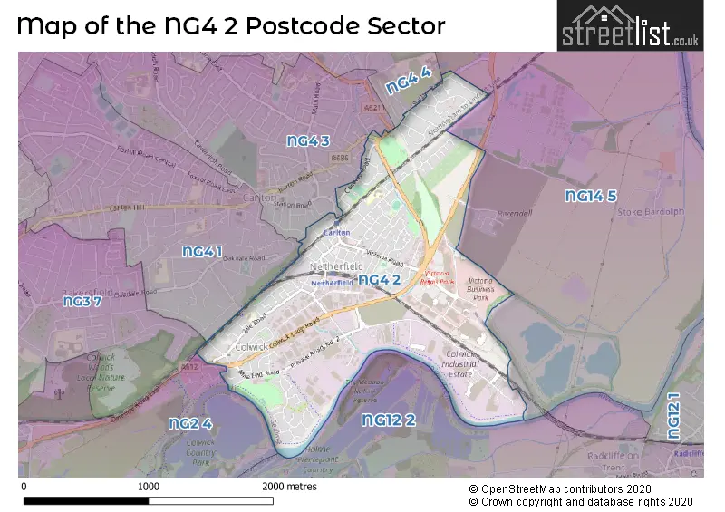
The NG4 2 Postcode shares a border with NG12 2 (Radcliffe-on-Trent, Holme Pierrepont), NG4 3 (Carlton, Gedling), NG4 4 (Gedling, Lambley, Carlton), NG2 4 (NOTTINGHAM, Colwick Park, Sneinton), NG3 7 (NOTTINGHAM), NG4 1 (Carlton) and NG14 5 (Burton Joyce, Bulcote).
Map of the NG4 2 Postcode Sector
Explore the NG4 2 postcode sector by using our interactive map.
The sector is within the post town of NOTTINGHAM.
NG4 2 is a postcode sector within the NG4 postcode district which is within the NG Nottingham postcode area.
The Royal Mail delivery office for the NG4 2 postal sector is the Carlton (ng) Delivery Office.
The area of the NG4 2 postcode sector is 1.42 square miles which is 3.69 square kilometres or 911.38 square acres.
Waterways within the NG4 2 postcode sector include the River Trent.
Your support helps keep this site running!
If you enjoy using this website, consider buying me a coffee to help cover hosting costs.


| N | G | 4 | - | 2 | X | X |
| N | G | 4 | Space | 2 | Letter | Letter |
Official List of Streets
Gedling (18 Streets)
Netherfield (58 Streets)
Colwick (44 Streets)
(7 Streets)
Carlton (6 Streets)
Colwick Industrial Estate (6 Streets)
Unofficial Streets or Alternative Spellings
Burton Joyce
MAGENTA WAY NEW WORKS COTTAGES STOKE LANE MIDLAND WOOD CYCLE ROUTE OAKLEY COURT OUSE BRIDGE DRIVE PRIVATE ROAD NO. 1 PRIVATE ROAD NO. 2 PRIVATE ROAD NO. 3 PRIVATE ROAD NO. 4 PRIVATE ROAD NO. 5 PRIVATE ROAD NO. 7 PRIVATE ROAD NO. 8 ROAD NO 1 ROAD NO 4 ROAD NO 8 SENSO COURT STOKE ROADGedling
BROOKLANDS DRIVE CORONATION WALK SHEARING HILLCarlton
BURTON ROAD ELM DRIVE STATION ROAD WILLOW ROADWeather Forecast for NG4 2
Weather Forecast for Carlton (Nottinghamshire)
| Time Period | Icon | Description | Temperature | Rain Probability | Wind |
|---|---|---|---|---|---|
| 15:00 to 18:00 | Cloudy | 9.0°C (feels like 6.0°C) | 5.00% | SSW 9 mph | |
| 18:00 to 21:00 | Cloudy | 7.0°C (feels like 5.0°C) | 5.00% | SSW 9 mph | |
| 21:00 to 00:00 | Cloudy | 6.0°C (feels like 3.0°C) | 4.00% | SSW 9 mph |
| Time Period | Icon | Description | Temperature | Rain Probability | Wind |
|---|---|---|---|---|---|
| 00:00 to 03:00 | Cloudy | 5.0°C (feels like 2.0°C) | 4.00% | SSW 9 mph | |
| 03:00 to 06:00 | Cloudy | 6.0°C (feels like 3.0°C) | 4.00% | SSW 11 mph | |
| 06:00 to 09:00 | Cloudy | 6.0°C (feels like 3.0°C) | 6.00% | SSW 11 mph | |
| 09:00 to 12:00 | Cloudy | 8.0°C (feels like 4.0°C) | 5.00% | SSW 13 mph | |
| 12:00 to 15:00 | Cloudy | 10.0°C (feels like 7.0°C) | 13.00% | SSW 16 mph | |
| 15:00 to 18:00 | Light rain | 10.0°C (feels like 7.0°C) | 86.00% | SSW 16 mph | |
| 18:00 to 21:00 | Cloudy | 9.0°C (feels like 6.0°C) | 55.00% | WSW 11 mph | |
| 21:00 to 00:00 | Clear night | 7.0°C (feels like 4.0°C) | 2.00% | WSW 11 mph |
| Time Period | Icon | Description | Temperature | Rain Probability | Wind |
|---|---|---|---|---|---|
| 00:00 to 03:00 | Clear night | 6.0°C (feels like 2.0°C) | 0.00% | WSW 9 mph | |
| 03:00 to 06:00 | Clear night | 4.0°C (feels like 1.0°C) | 0.00% | WSW 9 mph | |
| 06:00 to 09:00 | Clear night | 3.0°C (feels like 0.0°C) | 1.00% | WSW 7 mph | |
| 09:00 to 12:00 | Cloudy | 4.0°C (feels like 1.0°C) | 4.00% | WSW 7 mph | |
| 12:00 to 15:00 | Cloudy | 7.0°C (feels like 5.0°C) | 4.00% | W 9 mph | |
| 15:00 to 18:00 | Cloudy | 8.0°C (feels like 6.0°C) | 4.00% | WNW 7 mph | |
| 18:00 to 21:00 | Clear night | 4.0°C (feels like 2.0°C) | 0.00% | WNW 4 mph | |
| 21:00 to 00:00 | Clear night | 2.0°C (feels like 0.0°C) | 0.00% | WNW 4 mph |
| Time Period | Icon | Description | Temperature | Rain Probability | Wind |
|---|---|---|---|---|---|
| 00:00 to 03:00 | Clear night | 0.0°C (feels like -1.0°C) | 0.00% | WNW 2 mph | |
| 03:00 to 06:00 | Clear night | 0.0°C (feels like -2.0°C) | 0.00% | NNW 2 mph | |
| 06:00 to 09:00 | Clear night | -1.0°C (feels like -3.0°C) | 1.00% | N 2 mph | |
| 09:00 to 12:00 | Sunny day | 1.0°C (feels like -1.0°C) | 3.00% | NE 2 mph | |
| 12:00 to 15:00 | Sunny day | 6.0°C (feels like 5.0°C) | 0.00% | ENE 4 mph | |
| 15:00 to 18:00 | Sunny day | 7.0°C (feels like 6.0°C) | 0.00% | ENE 7 mph | |
| 18:00 to 21:00 | Clear night | 3.0°C (feels like 1.0°C) | 0.00% | ENE 7 mph | |
| 21:00 to 00:00 | Clear night | 1.0°C (feels like -1.0°C) | 1.00% | ENE 4 mph |
| Time Period | Icon | Description | Temperature | Rain Probability | Wind |
|---|---|---|---|---|---|
| 00:00 to 03:00 | Fog | 1.0°C (feels like -1.0°C) | 15.00% | NE 7 mph | |
| 03:00 to 06:00 | Fog | 1.0°C (feels like -2.0°C) | 15.00% | NE 7 mph | |
| 06:00 to 09:00 | Fog | 1.0°C (feels like -2.0°C) | 16.00% | NE 7 mph | |
| 09:00 to 12:00 | Fog | 2.0°C (feels like -1.0°C) | 16.00% | NE 7 mph | |
| 12:00 to 15:00 | Cloudy | 5.0°C (feels like 2.0°C) | 6.00% | NE 9 mph | |
| 15:00 to 18:00 | Sunny day | 6.0°C (feels like 3.0°C) | 2.00% | ENE 9 mph | |
| 18:00 to 21:00 | Clear night | 3.0°C (feels like 0.0°C) | 2.00% | NE 7 mph | |
| 21:00 to 00:00 | Overcast | 2.0°C (feels like -1.0°C) | 8.00% | NE 7 mph |
Schools and Places of Education Within the NG4 2 Postcode Sector
Netherfield Primary School
Academy sponsor led
Chandos Street, Nottingham, Nottinghamshire, NG4 2LR
Head: Mr Jon Crone
Ofsted Rating: Good
Inspection: 2022-07-20 (929 days ago)
Website: Visit Netherfield Primary School Website
Phone: 01159610580
Number of Pupils: 455
St John's CofE Primary School
Voluntary aided school
Vale Road, Nottingham, Nottinghamshire, NG4 2ED
Head: Miss Rachel Ireland
Ofsted Rating: Good
Inspection: 2019-02-26 (2169 days ago)
Website: Visit St John's CofE Primary School Website
Phone: 01159115599
Number of Pupils: 201
Venture Learning
Other independent special school
19A Forester Street, , , NG4 2LJ
Head: Mr Rich Hill
Ofsted Rating: Good
Inspection: 2022-11-10 (816 days ago)
Website: Visit Venture Learning Website
Phone: 07587408996
Number of Pupils: 13
House Prices in the NG4 2 Postcode Sector
| Type of Property | 2018 Average | 2018 Sales | 2017 Average | 2017 Sales | 2016 Average | 2016 Sales | 2015 Average | 2015 Sales |
|---|---|---|---|---|---|---|---|---|
| Detached | £271,380 | 25 | £251,411 | 23 | £262,912 | 17 | £235,733 | 15 |
| Semi-Detached | £157,214 | 74 | £142,154 | 58 | £131,398 | 61 | £132,048 | 52 |
| Terraced | £116,000 | 94 | £109,255 | 102 | £104,334 | 103 | £97,693 | 108 |
| Flats | £97,317 | 9 | £86,950 | 10 | £89,158 | 6 | £94,500 | 9 |
Important Postcodes NG4 2 in the Postcode Sector
NG4 2ED is the postcode for ST JOHN THE BAPTIST PRIMARY SCHOOL, VALE ROAD, COLWICK
NG4 2HU is the postcode for Netherfield Childrens Centre, 143 Victoria Road
NG4 2JY is the postcode for Greenwood Academies Trust, 4 Colwick Quays Business Park, Road No 2
NG4 2LR is the postcode for Carlton Netherfield Primary School, Chandos Street, Netherfield Primary School, Chandos Street, and Carlton Netherfield Primary School, Chandos Street, Netherfield
NG4 2NJ is the postcode for Netherfield Medical Centre, 2a Forester Street
NG4 2PH is the postcode for Gedling Day Service, Ley Street
NG4 2SQ is the postcode for Parcelforce Worldwide, Unit 2, Drake Road
| The NG4 2 Sector is within these Local Authorities |
|
|---|---|
| The NG4 2 Sector is within these Counties |
|
| The NG4 2 Sector is within these Water Company Areas |
|