A wide range of spatial data has been analysed to present this overview of the NG32 2 Postcode sector. If you would like anything added, please contact us.
The NG32 2 postcode sector stands on the Leicestershire and Lincolnshire border.
Did you know? According to the 2021 Census, the NG32 2 postcode sector is home to a bustling 3,673 residents!
Given that each sector allows for 400 unique postcode combinations. Letters C, I, K, M, O and V are not allowed in the last two letters of a postcode. With 177 postcodes already in use, this leaves 223 units available.
The largest settlement in the NG32 2 postal code is Allington followed by Barkston, and Foston.
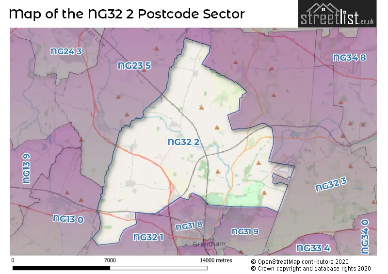
The NG32 2 Postcode shares a border with NG31 9 (GRANTHAM, Londonthorpe), NG13 0 (Bottesford, Redmile, Barkestone), NG23 5 (Long Bennington, Claypole, Elston), NG31 8 (GRANTHAM, Gonerby Hill Foot, Great Gonerby), NG32 1 (Barrowby, Harlaxton, Croxton Kerrial) and NG32 3 (Ancaster, Caythorpe, Fulbeck).
Map of the NG32 2 Postcode Sector
Explore the NG32 2 postcode sector by using our interactive map.
The sector is within the post town of GRANTHAM.
NG32 2 is a postcode sector within the NG32 postcode district which is within the NG Nottingham postcode area.
The Royal Mail delivery office for the NG32 2 postal sector is the Grantham Delivery Office.
The area of the NG32 2 postcode sector is 39.91 square miles which is 103.37 square kilometres or 25,544.03 square acres.
The NG32 2 postcode sector is crossed by the A1 Major A road.
The NG32 2 postcode sector is crossed by the A52 Major A road.
Waterways within the NG32 2 postcode sector include the River Witham, River Brant, Sand Beck, Grantham Canal.
Your support helps keep this site running!
If you enjoy using this website, consider buying me a coffee to help cover hosting costs.

| N | G | 3 | 2 | - | 2 | X | X |
| N | G | 3 | 2 | Space | 2 | Letter | Letter |
Official List of Streets
Sedgebrook (10 Streets)
Allington (21 Streets)
Foston (17 Streets)
(22 Streets)
Barkston (15 Streets)
Marston (13 Streets)
Brandon (6 Streets)
Honington (10 Streets)
Hougham (9 Streets)
Hough-on-the-Hill (9 Streets)
Belton (3 Streets)
Great Gonerby (1 Streets)
Syston Park (1 Streets)
Gonerby Moor (2 Streets)
Syston (2 Streets)
Unofficial Streets or Alternative Spellings
Stubton
BRANDON ROADMuston
WOOLSTHORPE LANEAncaster
WILLOUGHBY ROADFrieston
HOUGH ROADCaythorpe
GORSE HILL LANE WHEATGRASS LANEWestborough
EASE LANEWoolsthorpe
SEDGEBROOK ROADBottesford
GRANTHAM ROADCasthorpe
DENTON LANEWeather Forecast for NG32 2
Weather Forecast for Belton House
| Time Period | Icon | Description | Temperature | Rain Probability | Wind |
|---|---|---|---|---|---|
| 03:00 to 06:00 | Cloudy | 4.0°C (feels like 1.0°C) | 5.00% | SSW 7 mph | |
| 06:00 to 09:00 | Cloudy | 4.0°C (feels like 1.0°C) | 8.00% | SSW 7 mph | |
| 09:00 to 12:00 | Cloudy | 5.0°C (feels like 2.0°C) | 9.00% | SSW 9 mph | |
| 12:00 to 15:00 | Cloudy | 8.0°C (feels like 5.0°C) | 5.00% | SW 11 mph | |
| 15:00 to 18:00 | Cloudy | 9.0°C (feels like 6.0°C) | 5.00% | SSW 11 mph | |
| 18:00 to 21:00 | Cloudy | 7.0°C (feels like 4.0°C) | 5.00% | SSW 9 mph | |
| 21:00 to 00:00 | Cloudy | 6.0°C (feels like 3.0°C) | 5.00% | S 11 mph |
| Time Period | Icon | Description | Temperature | Rain Probability | Wind |
|---|---|---|---|---|---|
| 00:00 to 03:00 | Cloudy | 6.0°C (feels like 3.0°C) | 5.00% | SSW 13 mph | |
| 03:00 to 06:00 | Cloudy | 6.0°C (feels like 2.0°C) | 5.00% | SSW 13 mph | |
| 06:00 to 09:00 | Cloudy | 6.0°C (feels like 2.0°C) | 4.00% | SSW 13 mph | |
| 09:00 to 12:00 | Cloudy | 7.0°C (feels like 3.0°C) | 5.00% | SSW 16 mph | |
| 12:00 to 15:00 | Cloudy | 10.0°C (feels like 6.0°C) | 10.00% | SSW 18 mph | |
| 15:00 to 18:00 | Light rain | 10.0°C (feels like 7.0°C) | 54.00% | SSW 16 mph | |
| 18:00 to 21:00 | Light rain | 9.0°C (feels like 6.0°C) | 57.00% | SW 11 mph | |
| 21:00 to 00:00 | Clear night | 7.0°C (feels like 4.0°C) | 11.00% | SW 11 mph |
| Time Period | Icon | Description | Temperature | Rain Probability | Wind |
|---|---|---|---|---|---|
| 00:00 to 03:00 | Clear night | 6.0°C (feels like 2.0°C) | 2.00% | WSW 11 mph | |
| 03:00 to 06:00 | Clear night | 5.0°C (feels like 1.0°C) | 1.00% | WSW 11 mph | |
| 06:00 to 09:00 | Clear night | 3.0°C (feels like 0.0°C) | 1.00% | WSW 9 mph | |
| 09:00 to 12:00 | Cloudy | 4.0°C (feels like 0.0°C) | 4.00% | WSW 9 mph | |
| 12:00 to 15:00 | Partly cloudy (day) | 7.0°C (feels like 4.0°C) | 1.00% | W 9 mph | |
| 15:00 to 18:00 | Partly cloudy (day) | 7.0°C (feels like 5.0°C) | 1.00% | WNW 9 mph | |
| 18:00 to 21:00 | Clear night | 4.0°C (feels like 2.0°C) | 1.00% | W 4 mph | |
| 21:00 to 00:00 | Clear night | 2.0°C (feels like 0.0°C) | 1.00% | W 4 mph |
| Time Period | Icon | Description | Temperature | Rain Probability | Wind |
|---|---|---|---|---|---|
| 00:00 to 03:00 | Clear night | 1.0°C (feels like -1.0°C) | 1.00% | WNW 4 mph | |
| 03:00 to 06:00 | Clear night | 0.0°C (feels like -2.0°C) | 1.00% | NW 4 mph | |
| 06:00 to 09:00 | Clear night | -1.0°C (feels like -3.0°C) | 2.00% | NNW 4 mph | |
| 09:00 to 12:00 | Sunny day | 1.0°C (feels like -1.0°C) | 2.00% | NNE 4 mph | |
| 12:00 to 15:00 | Sunny day | 6.0°C (feels like 5.0°C) | 0.00% | ENE 4 mph | |
| 15:00 to 18:00 | Sunny day | 7.0°C (feels like 5.0°C) | 0.00% | ENE 7 mph | |
| 18:00 to 21:00 | Clear night | 3.0°C (feels like 1.0°C) | 0.00% | ENE 7 mph | |
| 21:00 to 00:00 | Clear night | 2.0°C (feels like -1.0°C) | 1.00% | ENE 7 mph |
Schools and Places of Education Within the NG32 2 Postcode Sector
Allington with Sedgebrook Church of England Primary School
Voluntary controlled school
Marston Lane, Grantham, Lincolnshire, NG32 2DY
Head: Mrs Victoria Hammond
Ofsted Rating: Good
Inspection: 2020-02-12 (1818 days ago)
Website: Visit Allington with Sedgebrook Church of England Primary School Website
Phone: 01400281685
Number of Pupils: 112
Barkston and Syston CofE Primary School
Voluntary aided school
Church Street, Grantham, Lincolnshire, NG32 2NB
Head: Miss Rebecca J Lyon
Ofsted Rating: Good
Inspection: 2023-02-28 (706 days ago)
Website: Visit Barkston and Syston CofE Primary School Website
Phone: 01400250553
Number of Pupils: 92
The Marston Thorold's Charity Church of England School
Voluntary aided school
School Lane, Grantham, Lincolnshire, NG32 2HQ
Head: Mrs Elaine Bedford
Ofsted Rating: Good
Inspection: 2020-03-11 (1790 days ago)
Website: Visit The Marston Thorold's Charity Church of England School Website
Phone: 01400250583
Number of Pupils: 76
House Prices in the NG32 2 Postcode Sector
| Type of Property | 2018 Average | 2018 Sales | 2017 Average | 2017 Sales | 2016 Average | 2016 Sales | 2015 Average | 2015 Sales |
|---|---|---|---|---|---|---|---|---|
| Detached | £369,357 | 33 | £375,296 | 27 | £397,276 | 36 | £306,903 | 37 |
| Semi-Detached | £196,825 | 8 | £220,063 | 16 | £250,063 | 8 | £151,250 | 8 |
| Terraced | £300,167 | 3 | £261,250 | 4 | £224,333 | 6 | £186,000 | 2 |
| Flats | £0 | 0 | £0 | 0 | £0 | 0 | £0 | 0 |
Important Postcodes NG32 2 in the Postcode Sector
NG32 2DY is the postcode for Allington Primary School, Marston Lane
NG32 2HQ is the postcode for Marston Thorolds Charity C of E School, School Lane
NG32 2NB is the postcode for Barkston & Syston C of E School, Church Street
| The NG32 2 Sector is within these Local Authorities |
|
|---|---|
| The NG32 2 Sector is within these Counties |
|
| The NG32 2 Sector is within these Water Company Areas |
|
Tourist Attractions within the NG32 2 Postcode Area
We found 1 visitor attractions within the NG32 postcode area
| Belton House |
|---|
| Historic Properties |
| Historic House / House and Garden / Palace |
| View Belton House on Google Maps |