A wide range of spatial data has been analysed to present this overview of the NG24 2 Postcode sector. If you would like anything added, please contact us.
The NG24 2 postcode sector stands on the Lincolnshire and Nottinghamshire border.
Did you know? According to the 2021 Census, the NG24 2 postcode sector is home to a bustling 10,680 residents!
Given that each sector allows for 400 unique postcode combinations. Letters C, I, K, M, O and V are not allowed in the last two letters of a postcode. With 279 postcodes already in use, this leaves 121 units available.
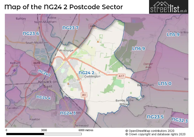
The largest settlement in the NG24 2 postal code is NEWARK followed by Coddington, and Winthorpe.
The NG24 2 Postcode shares a border with LN5 0 (Navenby, Wellingore, Brant Broughton), LN6 9 (North Hykeham, Witham St. Hughs, South Hykeham), NG23 5 (Long Bennington, Claypole, Elston), NG23 6 (Sutton-on-Trent, North Muskham, Caunton), NG23 7 (Collingham, Harby, Thorney), NG24 1 (NEWARK) and NG24 3 (Balderton, Fernwood, Farndon).
Map of the NG24 2 Postcode Sector
Explore the NG24 2 postcode sector by using our interactive map.
The sector is within the post town of NEWARK.
NG24 2 is a postcode sector within the NG24 postcode district which is within the NG Nottingham postcode area.
The Royal Mail delivery office for the NG24 2 postal sector is the Newark Delivery Office.
The area of the NG24 2 postcode sector is 12.95 square miles which is 33.53 square kilometres or 8,285.27 square acres.
The NG24 2 postcode sector is crossed by the A1 Major A road.
The NG24 2 postcode sector is crossed by the A46 Major A road.
Waterways within the NG24 2 postcode sector include the River Trent, River Witham, Shire Dyke.
Your support helps keep this site running!
If you enjoy using this website, consider buying me a coffee to help cover hosting costs.


| N | G | 2 | 4 | - | 2 | X | X |
| N | G | 2 | 4 | Space | 2 | Letter | Letter |
Official List of Streets
NEWARK (138 Streets)
Barnby (8 Streets)
Coddington (37 Streets)
Winthorpe (14 Streets)
(13 Streets)
Danethorpe (2 Streets)
Newark Industrial Estate (1 Streets)
Northern Road Industrial Estate (1 Streets)
Unofficial Streets or Alternative Spellings
Balderton
BARNBY ROAD BULLPIT ROAD CODDINGTON ROAD FEN LANENEWARK
CROMWELL ROADLangford
GAINSBOROUGH ROADBrough
STAPLEFORD LANEWeather Forecast for NG24 2
Weather Forecast for Newark-On-Trent
| Time Period | Icon | Description | Temperature | Rain Probability | Wind |
|---|---|---|---|---|---|
| 12:00 to 15:00 | Overcast | 6.0°C (feels like 3.0°C) | 8.00% | S 9 mph | |
| 15:00 to 18:00 | Overcast | 7.0°C (feels like 4.0°C) | 9.00% | S 9 mph | |
| 18:00 to 21:00 | Overcast | 6.0°C (feels like 3.0°C) | 8.00% | SSE 9 mph | |
| 21:00 to 00:00 | Overcast | 5.0°C (feels like 1.0°C) | 8.00% | S 9 mph |
| Time Period | Icon | Description | Temperature | Rain Probability | Wind |
|---|---|---|---|---|---|
| 00:00 to 03:00 | Partly cloudy (night) | 3.0°C (feels like -1.0°C) | 2.00% | S 9 mph | |
| 03:00 to 06:00 | Cloudy | 2.0°C (feels like -2.0°C) | 4.00% | SSE 9 mph | |
| 06:00 to 09:00 | Partly cloudy (night) | 2.0°C (feels like -2.0°C) | 2.00% | SSE 9 mph | |
| 09:00 to 12:00 | Sunny day | 2.0°C (feels like -1.0°C) | 3.00% | S 9 mph | |
| 12:00 to 15:00 | Sunny day | 6.0°C (feels like 2.0°C) | 3.00% | S 9 mph | |
| 15:00 to 18:00 | Sunny day | 7.0°C (feels like 4.0°C) | 2.00% | SSW 9 mph | |
| 18:00 to 21:00 | Clear night | 4.0°C (feels like 1.0°C) | 1.00% | SSW 7 mph | |
| 21:00 to 00:00 | Clear night | 3.0°C (feels like 0.0°C) | 1.00% | SSW 7 mph |
| Time Period | Icon | Description | Temperature | Rain Probability | Wind |
|---|---|---|---|---|---|
| 00:00 to 03:00 | Clear night | 3.0°C (feels like 0.0°C) | 1.00% | SSW 7 mph | |
| 03:00 to 06:00 | Partly cloudy (night) | 3.0°C (feels like -1.0°C) | 2.00% | SSW 7 mph | |
| 06:00 to 09:00 | Cloudy | 3.0°C (feels like -1.0°C) | 5.00% | SSW 9 mph | |
| 09:00 to 12:00 | Overcast | 4.0°C (feels like 0.0°C) | 8.00% | SSW 9 mph | |
| 12:00 to 15:00 | Cloudy | 7.0°C (feels like 4.0°C) | 5.00% | SSW 11 mph | |
| 15:00 to 18:00 | Cloudy | 8.0°C (feels like 5.0°C) | 5.00% | SSW 11 mph | |
| 18:00 to 21:00 | Partly cloudy (night) | 7.0°C (feels like 4.0°C) | 2.00% | S 11 mph | |
| 21:00 to 00:00 | Cloudy | 6.0°C (feels like 3.0°C) | 5.00% | SSW 13 mph |
| Time Period | Icon | Description | Temperature | Rain Probability | Wind |
|---|---|---|---|---|---|
| 00:00 to 03:00 | Cloudy | 6.0°C (feels like 3.0°C) | 6.00% | SSW 13 mph | |
| 03:00 to 06:00 | Cloudy | 6.0°C (feels like 3.0°C) | 11.00% | SSW 13 mph | |
| 06:00 to 09:00 | Cloudy | 7.0°C (feels like 3.0°C) | 14.00% | SSW 13 mph | |
| 09:00 to 12:00 | Partly cloudy (day) | 7.0°C (feels like 4.0°C) | 13.00% | SSW 13 mph | |
| 12:00 to 15:00 | Partly cloudy (day) | 9.0°C (feels like 6.0°C) | 15.00% | SSW 13 mph | |
| 15:00 to 18:00 | Light rain | 10.0°C (feels like 7.0°C) | 45.00% | SW 13 mph | |
| 18:00 to 21:00 | Cloudy | 8.0°C (feels like 6.0°C) | 12.00% | SW 11 mph | |
| 21:00 to 00:00 | Partly cloudy (night) | 7.0°C (feels like 4.0°C) | 8.00% | WSW 9 mph |
Schools and Places of Education Within the NG24 2 Postcode Sector
Bishop Alexander L.E.A.D. Academy
Academy sponsor led
Wolsey Road, Newark, Nottinghamshire, NG24 2BQ
Head: Mrs Nicky Spencelayh
Ofsted Rating: Good
Inspection: 2023-03-22 (682 days ago)
Website: Visit Bishop Alexander L.E.A.D. Academy Website
Phone: 01636680040
Number of Pupils: 247
Coddington CofE Primary and Nursery School
Voluntary controlled school
Brownlows Hill, Newark, Nottinghamshire, NG24 2QA
Head: Mrs R Major
Ofsted Rating: Good
Inspection: 2019-01-15 (2209 days ago)
Website: Visit Coddington CofE Primary and Nursery School Website
Phone: 01636702974
Number of Pupils: 412
Winthorpe Primary School
Academy converter
Thoroughfare Lane, Newark, Nottinghamshire, NG24 2NN
Head: Mr Rob Cook
Ofsted Rating: Good
Inspection: 2023-03-14 (690 days ago)
Website: Visit Winthorpe Primary School Website
Phone: 01636680060
Number of Pupils: 98
House Prices in the NG24 2 Postcode Sector
| Type of Property | 2018 Average | 2018 Sales | 2017 Average | 2017 Sales | 2016 Average | 2016 Sales | 2015 Average | 2015 Sales |
|---|---|---|---|---|---|---|---|---|
| Detached | £268,230 | 116 | £250,648 | 101 | £233,404 | 110 | £227,135 | 101 |
| Semi-Detached | £163,479 | 50 | £149,930 | 70 | £145,237 | 65 | £122,892 | 48 |
| Terraced | £129,219 | 46 | £128,474 | 43 | £140,700 | 52 | £128,976 | 45 |
| Flats | £91,000 | 4 | £91,277 | 9 | £133,795 | 5 | £155,950 | 1 |
Important Postcodes NG24 2 in the Postcode Sector
NG24 2AL is the postcode for Maple Teaching Unit, Magnus Academy, Quibells Lane
NG24 2BQ is the postcode for Bishop Alexander Primary School, Wolsey Road, Bishop Alexander L E A D Academy, Wolsey Road, and BISHOP ALEXANDER L E A D ACADEMY, WOLSEY ROAD, NOTTINGHAMSHIRE
NG24 2DQ is the postcode for Bridge Childrens Centre, Lincoln Road
NG24 2NN is the postcode for Winthorpe Primary School, Gainsborough Road, and Winthorpe Primary School, Gainsborough Road, Winthorpe
NG24 2QA is the postcode for CODDINGTON C OF E PRIMARY SCHOOL, BROWNLOWS HILL, CODDINGTON, TEACHING BLOCK 5, Coddington C of E Primary School, Brownlows Hill, and Coddington C of E Primary School, Brownlows Hill
NG24 2TN is the postcode for Newark Beacon, Cafferata Way, and Newark Beacon Innovation Centre, Beacon Hill Office Park
| The NG24 2 Sector is within these Local Authorities |
|
|---|---|
| The NG24 2 Sector is within these Counties |
|
| The NG24 2 Sector is within these Water Company Areas |
|
Tourist Attractions within the NG24 2 Postcode Area
We found 1 visitor attractions within the NG24 postcode area
| Newark Air Museum |
|---|
| Museums & Art Galleries |
| Museum and / or Art Gallery |
| View Newark Air Museum on Google Maps |