A wide range of spatial data has been analysed to present this overview of the NG22 8 Postcode sector. If you would like anything added, please contact us.
The NG22 8 postcode sector is within the county of Nottinghamshire.
Did you know? According to the 2021 Census, the NG22 8 postcode sector is home to a bustling 8,172 residents!
Given that each sector allows for 400 unique postcode combinations. Letters C, I, K, M, O and V are not allowed in the last two letters of a postcode. With 288 postcodes already in use, this leaves 112 units available.
The largest settlement in the NG22 8 postal code is Bilsthorpe followed by Farnsfield, and Kirklington.
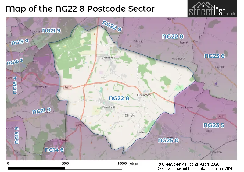
The NG22 8 Postcode shares a border with NG21 0 (Rainworth, Blidworth), NG21 9 (Edwinstowe, Clipstone Village, Kings Clipstone), NG22 0 (Tuxford, East Markham, Wellow), NG22 9 (New Ollerton, Ollerton, Boughton), NG23 6 (Sutton-on-Trent, North Muskham, Caunton) and NG25 0 (SOUTHWELL, Fiskerton, Oxton).
Map of the NG22 8 Postcode Sector
Explore the NG22 8 postcode sector by using our interactive map.
The sector is within the post town of NEWARK.
NG22 8 is a postcode sector within the NG22 postcode district which is within the NG Nottingham postcode area.
The Royal Mail delivery office for the NG22 8 postal sector is the Bilsthorpe Scale Payment Delivery Office and Newark Delivery Office.
The area of the NG22 8 postcode sector is 31.18 square miles which is 80.77 square kilometres or 19,957.82 square acres.
Waterways within the NG22 8 postcode sector include the River Greet, Rainworth Water.
Your support helps keep this site running!
If you enjoy using this website, consider buying me a coffee to help cover hosting costs.

| N | G | 2 | 2 | - | 8 | X | X |
| N | G | 2 | 2 | Space | 8 | Letter | Letter |
Official List of Streets
Farnsfield (69 Streets)
Bilsthorpe (77 Streets)
Edingley (11 Streets)
Halam (10 Streets)
(31 Streets)
Winkburn (2 Streets)
Kirklington (13 Streets)
Unofficial Streets or Alternative Spellings
SOUTHWELL
LOWER KIRKLINGTON ROADEakring
BRAIL LANE TENTERS LANEMANSFIELD
EAKRING ROADWeather Forecast for NG22 8
Weather Forecast for Wheelgate Park Farnsfield
| Time Period | Icon | Description | Temperature | Rain Probability | Wind |
|---|---|---|---|---|---|
| 21:00 to 00:00 | Cloudy | 5.0°C (feels like 2.0°C) | 5.00% | SSW 9 mph |
| Time Period | Icon | Description | Temperature | Rain Probability | Wind |
|---|---|---|---|---|---|
| 00:00 to 03:00 | Cloudy | 5.0°C (feels like 1.0°C) | 4.00% | SSW 13 mph | |
| 03:00 to 06:00 | Cloudy | 5.0°C (feels like 1.0°C) | 5.00% | SSW 13 mph | |
| 06:00 to 09:00 | Cloudy | 6.0°C (feels like 2.0°C) | 5.00% | SSW 13 mph | |
| 09:00 to 12:00 | Cloudy | 7.0°C (feels like 3.0°C) | 6.00% | SSW 18 mph | |
| 12:00 to 15:00 | Cloudy | 9.0°C (feels like 6.0°C) | 13.00% | SSW 18 mph | |
| 15:00 to 18:00 | Heavy rain | 10.0°C (feels like 6.0°C) | 82.00% | SSW 16 mph | |
| 18:00 to 21:00 | Light rain | 8.0°C (feels like 5.0°C) | 82.00% | SW 13 mph | |
| 21:00 to 00:00 | Clear night | 6.0°C (feels like 2.0°C) | 1.00% | SW 11 mph |
| Time Period | Icon | Description | Temperature | Rain Probability | Wind |
|---|---|---|---|---|---|
| 00:00 to 03:00 | Clear night | 5.0°C (feels like 1.0°C) | 1.00% | WSW 11 mph | |
| 03:00 to 06:00 | Clear night | 3.0°C (feels like 0.0°C) | 0.00% | WSW 9 mph | |
| 06:00 to 09:00 | Clear night | 3.0°C (feels like -1.0°C) | 1.00% | WSW 9 mph | |
| 09:00 to 12:00 | Partly cloudy (day) | 3.0°C (feels like 0.0°C) | 1.00% | WSW 9 mph | |
| 12:00 to 15:00 | Cloudy | 7.0°C (feels like 4.0°C) | 4.00% | W 9 mph | |
| 15:00 to 18:00 | Partly cloudy (day) | 7.0°C (feels like 5.0°C) | 1.00% | WNW 7 mph | |
| 18:00 to 21:00 | Clear night | 3.0°C (feels like 1.0°C) | 0.00% | W 4 mph | |
| 21:00 to 00:00 | Clear night | 1.0°C (feels like -1.0°C) | 0.00% | WNW 4 mph |
| Time Period | Icon | Description | Temperature | Rain Probability | Wind |
|---|---|---|---|---|---|
| 00:00 to 03:00 | Clear night | 0.0°C (feels like -2.0°C) | 0.00% | WNW 2 mph | |
| 03:00 to 06:00 | Clear night | -1.0°C (feels like -3.0°C) | 0.00% | NW 2 mph | |
| 06:00 to 09:00 | Clear night | -2.0°C (feels like -4.0°C) | 0.00% | NNW 2 mph | |
| 09:00 to 12:00 | Sunny day | 0.0°C (feels like -2.0°C) | 4.00% | NNE 2 mph | |
| 12:00 to 15:00 | Sunny day | 5.0°C (feels like 4.0°C) | 0.00% | ENE 4 mph | |
| 15:00 to 18:00 | Sunny day | 7.0°C (feels like 5.0°C) | 0.00% | ENE 7 mph | |
| 18:00 to 21:00 | Clear night | 2.0°C (feels like 0.0°C) | 0.00% | ENE 4 mph | |
| 21:00 to 00:00 | Clear night | 1.0°C (feels like -2.0°C) | 2.00% | ENE 4 mph |
| Time Period | Icon | Description | Temperature | Rain Probability | Wind |
|---|---|---|---|---|---|
| 00:00 to 03:00 | Fog | 1.0°C (feels like -2.0°C) | 15.00% | NE 4 mph | |
| 03:00 to 06:00 | Fog | 1.0°C (feels like -2.0°C) | 15.00% | NE 7 mph | |
| 06:00 to 09:00 | Fog | 1.0°C (feels like -2.0°C) | 16.00% | NNE 7 mph | |
| 09:00 to 12:00 | Fog | 1.0°C (feels like -2.0°C) | 16.00% | NE 7 mph | |
| 12:00 to 15:00 | Cloudy | 4.0°C (feels like 1.0°C) | 6.00% | ENE 9 mph | |
| 15:00 to 18:00 | Sunny day | 5.0°C (feels like 2.0°C) | 1.00% | ENE 9 mph | |
| 18:00 to 21:00 | Clear night | 2.0°C (feels like 0.0°C) | 2.00% | NE 7 mph | |
| 21:00 to 00:00 | Partly cloudy (night) | 1.0°C (feels like -1.0°C) | 2.00% | NE 7 mph |
Schools and Places of Education Within the NG22 8 Postcode Sector
Bilsthorpe Flying High Academy
Academy converter
Crompton Road, Newark, Nottinghamshire, NG22 8PS
Head: Miss Samantha Leek
Ofsted Rating: Good
Inspection: 2018-09-27 (2321 days ago)
Website: Visit Bilsthorpe Flying High Academy Website
Phone: 01623870772
Number of Pupils: 214
Farnsfield St Michael's Church of England Primary School
Academy converter
Branston Avenue, Farnsfield, Nottinghamshire, NG22 8JZ
Head: Mrs Louise Carpenter
Ofsted Rating: Good
Inspection: 2023-10-18 (474 days ago)
Website: Visit Farnsfield St Michael's Church of England Primary School Website
Phone: 01623882494
Number of Pupils: 271
Kirklington Primary School
Community school
School Lane, Newark, Nottinghamshire, NG22 8NG
Head: Mrs Tracy Burn-Smith
Ofsted Rating: Good
Inspection: 2023-01-31 (734 days ago)
Website: Visit Kirklington Primary School Website
Phone: 01636812360
Number of Pupils: 102
Wings School Notts
Other independent special school
Main Street, Nottinghamshire, Middlesex, NG22 8NB
Head: Mr Jacob Shelton
Ofsted Rating: Good
Inspection: 2023-06-22 (592 days ago)
Website: Visit Wings School Notts Website
Phone: 01636817430
Number of Pupils: 35
House Prices in the NG22 8 Postcode Sector
| Type of Property | 2018 Average | 2018 Sales | 2017 Average | 2017 Sales | 2016 Average | 2016 Sales | 2015 Average | 2015 Sales |
|---|---|---|---|---|---|---|---|---|
| Detached | £330,409 | 86 | £297,186 | 78 | £313,704 | 107 | £306,349 | 85 |
| Semi-Detached | £177,217 | 46 | £141,143 | 63 | £120,807 | 43 | £123,447 | 38 |
| Terraced | £151,658 | 12 | £110,855 | 20 | £126,940 | 22 | £134,643 | 14 |
| Flats | £0 | 0 | £0 | 0 | £0 | 0 | £0 | 0 |
Important Postcodes NG22 8 in the Postcode Sector
NG22 8AE is the postcode for Halam C of E School, The Turnpike
NG22 8JZ is the postcode for St. Michaels C of E School, Branston Avenue, and Farnsfield St Michael's CofE Primary School, Branston Avenue
NG22 8LA is the postcode for The Surgery, Station Lane
NG22 8NG is the postcode for Kirklington Primary School, School Lane
NG22 8PS is the postcode for Bilsthorpe Flying High Academy, Crompton Road, Bilsthorpe, and Bilsthorpe Flying High Academy, Crompton Road
NG22 8PY is the postcode for Bilsthorpe Youth Club, Eakring Road
NG22 8QB is the postcode for 35, Mickledale Lane, Bilsthorpe
NG22 8ST is the postcode for VIA East Midlands (Fleet Building MOT AREA), Bilsthorpe Business Park, Eakring Road
| The NG22 8 Sector is within these Local Authorities |
|
|---|---|
| The NG22 8 Sector is within these Counties |
|
| The NG22 8 Sector is within these Water Company Areas |
|