A wide range of spatial data has been analysed to present this overview of the NG20 0 Postcode sector. If you would like anything added, please contact us.
The NG20 0 postcode sector is within the county of Nottinghamshire.
Did you know? According to the 2021 Census, the NG20 0 postcode sector is home to a bustling 9,687 residents!
Given that each sector allows for 400 unique postcode combinations. Letters C, I, K, M, O and V are not allowed in the last two letters of a postcode. With 237 postcodes already in use, this leaves 163 units available.
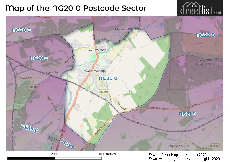
The largest settlements in the NG20 0 postal code are Warsop and Church Warsop.
The NG20 0 Postcode shares a border with NG19 9 (Mansfield Woodhouse), NG20 8 (Shirebrook, Warsop Vale), NG20 9 (Langwith, Meden Vale, Langwith Junction), NG19 8 (Mansfield Woodhouse, New Houghton, Pleasley Vale), NG21 9 (Edwinstowe, Clipstone Village, Kings Clipstone) and NG22 9 (New Ollerton, Ollerton, Boughton).
Map of the NG20 0 Postcode Sector
Explore the NG20 0 postcode sector by using our interactive map.
The sector is within the post town of MANSFIELD.
NG20 0 is a postcode sector within the NG20 postcode district which is within the NG Nottingham postcode area.
The Royal Mail delivery office for the NG20 0 postal sector is the Warsop Scale Payment Delivery Office.
The area of the NG20 0 postcode sector is 5.83 square miles which is 15.10 square kilometres or 3,731.54 square acres.
Waterways within the NG20 0 postcode sector include the River Meden.
Your support helps keep this site running!
If you enjoy using this website, consider buying me a coffee to help cover hosting costs.


| N | G | 2 | 0 | - | 0 | X | X |
| N | G | 2 | 0 | Space | 0 | Letter | Letter |
Official List of Streets
Warsop (108 Streets)
Church Warsop (33 Streets)
(24 Streets)
Unofficial Streets or Alternative Spellings
Weather Forecast for NG20 0
Weather Forecast for Market Warsop
| Time Period | Icon | Description | Temperature | Rain Probability | Wind |
|---|---|---|---|---|---|
| 06:00 to 09:00 | Overcast | 2.0°C (feels like -1.0°C) | 15.00% | NE 9 mph | |
| 09:00 to 12:00 | Overcast | 3.0°C (feels like 0.0°C) | 46.00% | NE 7 mph | |
| 12:00 to 15:00 | Light rain | 4.0°C (feels like 1.0°C) | 52.00% | NE 9 mph | |
| 15:00 to 18:00 | Light rain | 4.0°C (feels like 1.0°C) | 46.00% | NNE 7 mph | |
| 18:00 to 21:00 | Light rain | 4.0°C (feels like 2.0°C) | 53.00% | NNE 7 mph | |
| 21:00 to 00:00 | Overcast | 4.0°C (feels like 2.0°C) | 23.00% | NNE 4 mph |
| Time Period | Icon | Description | Temperature | Rain Probability | Wind |
|---|---|---|---|---|---|
| 00:00 to 03:00 | Overcast | 4.0°C (feels like 2.0°C) | 16.00% | NE 4 mph | |
| 03:00 to 06:00 | Overcast | 3.0°C (feels like 1.0°C) | 11.00% | NE 4 mph | |
| 06:00 to 09:00 | Mist | 3.0°C (feels like 1.0°C) | 20.00% | NE 4 mph | |
| 09:00 to 12:00 | Overcast | 4.0°C (feels like 1.0°C) | 15.00% | NNE 7 mph | |
| 12:00 to 15:00 | Overcast | 6.0°C (feels like 3.0°C) | 18.00% | NE 9 mph | |
| 15:00 to 18:00 | Overcast | 6.0°C (feels like 3.0°C) | 18.00% | NE 11 mph | |
| 18:00 to 21:00 | Overcast | 4.0°C (feels like 1.0°C) | 12.00% | NE 11 mph | |
| 21:00 to 00:00 | Overcast | 4.0°C (feels like 0.0°C) | 14.00% | NE 9 mph |
| Time Period | Icon | Description | Temperature | Rain Probability | Wind |
|---|---|---|---|---|---|
| 00:00 to 03:00 | Overcast | 4.0°C (feels like 0.0°C) | 16.00% | NE 11 mph | |
| 03:00 to 06:00 | Light rain | 4.0°C (feels like 0.0°C) | 42.00% | NE 9 mph | |
| 06:00 to 09:00 | Light rain | 3.0°C (feels like 0.0°C) | 44.00% | NE 11 mph | |
| 09:00 to 12:00 | Overcast | 3.0°C (feels like 0.0°C) | 18.00% | ENE 11 mph | |
| 12:00 to 15:00 | Overcast | 4.0°C (feels like 0.0°C) | 19.00% | ENE 11 mph | |
| 15:00 to 18:00 | Overcast | 4.0°C (feels like 0.0°C) | 19.00% | ENE 11 mph | |
| 18:00 to 21:00 | Overcast | 3.0°C (feels like -1.0°C) | 14.00% | ENE 9 mph | |
| 21:00 to 00:00 | Light rain | 3.0°C (feels like -1.0°C) | 45.00% | ENE 9 mph |
| Time Period | Icon | Description | Temperature | Rain Probability | Wind |
|---|---|---|---|---|---|
| 00:00 to 03:00 | Overcast | 3.0°C (feels like -1.0°C) | 20.00% | NE 9 mph | |
| 03:00 to 06:00 | Light snow | 2.0°C (feels like -1.0°C) | 51.00% | NE 7 mph | |
| 06:00 to 09:00 | Overcast | 2.0°C (feels like 0.0°C) | 19.00% | NE 7 mph | |
| 09:00 to 12:00 | Overcast | 3.0°C (feels like 0.0°C) | 14.00% | E 7 mph | |
| 12:00 to 15:00 | Overcast | 4.0°C (feels like 1.0°C) | 15.00% | E 9 mph | |
| 15:00 to 18:00 | Overcast | 4.0°C (feels like 1.0°C) | 16.00% | E 9 mph | |
| 18:00 to 21:00 | Cloudy | 3.0°C (feels like 0.0°C) | 10.00% | E 9 mph | |
| 21:00 to 00:00 | Overcast | 3.0°C (feels like 0.0°C) | 12.00% | E 7 mph |
Schools and Places of Education Within the NG20 0 Postcode Sector
Birklands Primary School
Academy sponsor led
Appleton Street, Mansfield, Nottinghamshire, NG20 0QF
Head: Mrs Vanessa Farr
Ofsted Rating: Good
Inspection: 2022-07-21 (933 days ago)
Website: Visit Birklands Primary School Website
Phone: 01623842163
Number of Pupils: 300
Church Vale Primary School and Foundation Unit
Community school
Laurel Avenue, Mansfield, Nottinghamshire, NG20 0TE
Head: Mrs Jo Yardley
Ofsted Rating: Good
Inspection: 2022-11-16 (815 days ago)
Website: Visit Church Vale Primary School and Foundation Unit Website
Phone: 01623842250
Number of Pupils: 222
Hetts Lane Infant and Nursery School
Community school
Hetts Lane, Mansfield, Nottinghamshire, NG20 0AS
Head: Mrs Lucy Stancliffe
Ofsted Rating: Good
Inspection: 2019-05-09 (2102 days ago)
Website: Visit Hetts Lane Infant and Nursery School Website
Phone: 01623842224
Number of Pupils: 199
Meden School
Academy sponsor led
Burns Lane, Mansfield, Nottinghamshire, NG20 0QN
Head: Mr Jim Smith
Ofsted Rating: Good
Inspection: 2023-06-28 (591 days ago)
Website: Visit Meden School Website
Phone: 01623843517
Number of Pupils: 1030
Sherwood Junior School
Community school
Sherwood Street, Mansfield, Nottinghamshire, NG20 0JT
Head: Mrs Helen Simpson
Ofsted Rating: Good
Inspection: 2021-11-03 (1193 days ago)
Website: Visit Sherwood Junior School Website
Phone: 01623842545
Number of Pupils: 186
House Prices in the NG20 0 Postcode Sector
| Type of Property | 2018 Average | 2018 Sales | 2017 Average | 2017 Sales | 2016 Average | 2016 Sales | 2015 Average | 2015 Sales |
|---|---|---|---|---|---|---|---|---|
| Detached | £200,237 | 44 | £163,298 | 52 | £169,684 | 51 | £179,149 | 59 |
| Semi-Detached | £114,977 | 61 | £111,030 | 59 | £113,127 | 101 | £107,731 | 58 |
| Terraced | £93,705 | 37 | £90,804 | 37 | £96,893 | 50 | £91,474 | 56 |
| Flats | £0 | 0 | £100,750 | 2 | £82,500 | 1 | £0 | 0 |
Important Postcodes NG20 0 in the Postcode Sector
NG20 0AN is the postcode for Surestart, Mansfield Road
NG20 0AS is the postcode for Hetts Lane Infant And Nursery School, Hetts Lane, and Hetts Lane School, Hetts Lane
NG20 0BP is the postcode for Ashfield & Mansfield Primary Care Trust, Church Street, Warsop Primary Care Centre, Church Street, Warsop, and Warsop Primary Care Centre, Church Street
NG20 0JT is the postcode for Sherwood Junior School, Sherwood Street, and Sherwood Junior School, Sherwood Street, Warsop
NG20 0QF is the postcode for MAIN BUILDING, Birklands Primary School, Appleton Street, and BIRKLANDS PRIMARY SCHOOL, APPLETON STREET
NG20 0QN is the postcode for Meden School, Main School Building, Burns Lane, EASTWOOD BLOCK, Meden School, Burns Lane, Meden School, Craft Block, Burns Lane, Meden School, Burns Lane, LEISURE CENTRE, Meden School, Burns Lane, CRAFT BLOCK, The Meden Comprehensive, Burns Lane, Meden Sports Centre, Burns Lane, MAIN SCHOOL BUILDING, Meden School, Burns Lane, CRAFT BLOCK, Meden School, Burns Lane, and Meden School, Eastwood Block, Burns Lane
NG20 0TE is the postcode for Church Vale Primary School, Laurel Avenue
| The NG20 0 Sector is within these Local Authorities |
|
|---|---|
| The NG20 0 Sector is within these Counties |
|
| The NG20 0 Sector is within these Water Company Areas |
|