
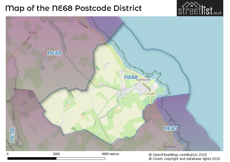
Map of the NE68 Postcode District
Explore the postcode district by using our interactive map.
Circles represent recorded crime; the larger the circle, the higher the crime rates.
Your support helps keep this site running!
If you enjoy using this website, consider buying me a coffee to help cover hosting costs.
Where is the NE68 District?
To give you an idea where the district is located we have created the following table showing nearby towns.
Nearest Towns to NE68
| Town | Distance (miles) | Direction |
|---|---|---|
| Alnwick | 11.28 | S |
| Wooler | 13.35 | W |
| Amble | 17.04 | SSE |
| Berwick-upon-Tweed | 18.64 | NW |
| Rothbury | 20.40 | SSW |
| Coldstream | 23.03 | WNW |
| Eyemouth | 26.12 | NW |
| Ashington | 27.39 | S |
| Newbiggin-by-the-Sea | 27.69 | SSE |
| Morpeth | 28.13 | S |
| Duns | 29.55 | WNW |
| Kelso | 29.65 | W |
| Bedlington | 30.79 | S |
| Blyth | 31.64 | SSE |
| Cramlington | 33.88 | S |
| Jedburgh | 35.03 | W |
| Ponteland | 36.38 | S |
| Whitley Bay | 37.74 | SSE |
| Longbenton | 38.49 | S |
| Tynemouth | 39.75 | SSE |
The post town for this district is SEAHOUSES.
Postcode Information for District NE68 (Total Geographical Postcodes: 121)
| Location | Post Town | Sector | Number of Postcodes |
|---|---|---|---|
| SEAHOUSES | SEAHOUSES | NE68 7 | 85 |
| North Sunderland | SEAHOUSES | NE68 7 | 35 |
| Shoreston | SEAHOUSES | NE68 7 | 1 |
Retail and Shopping in NE68
Street
Town
Locality
Number of Shops
Central Postcode
View on Google Maps
MAIN STREET
SEAHOUSES
39
NE68 7RQ
View on Google Maps
| Street | Town | Locality | Number of Shops | Central Postcode | View on Google Maps |
|---|---|---|---|---|---|
| MAIN STREET | SEAHOUSES | 39 | NE68 7RQ | View on Google Maps |
The primary settlement in the NE68 postcode district is Seahouses in the county of Northumberland, England. Other significant settlements include North Sunderland and Shoreston, both located in Northumberland. The post town for this postcode district is Seahouses.
When it comes to local government, postal geography often disregards political borders. However, this district intersects the following councils: the district mostly encompasses the Northumberland area with a total of 110 postal codes.
The largest settlements in the NE68 postal code are SEAHOUSES and North Sunderland.
The postcode area has a boundary with The North Sea.
The NE68 Postcode shares a border with NE69 (BAMBURGH) and NE67 (Beadnell, CHATHILL, Ellingham).
Postcode Sectors


Dentists in the NE68 District
No dentists found in this district.
Doctors in the NE68 District
| # | Name | Address | Type | Contact |
|---|---|---|---|---|
| 1 | Belford Medical Practice | , SEAHOUSES , NORTHUMBERLAND , NE68 7XZ | BRANCH SURGERY | |
| 2 | Seahouses Health Centre | , SEAHOUSES , NORTHUMBERLAND , NE68 7XZ | BRANCH SURGERY |
Chemists in the NE68 District
| # | Name | Address | Type | Contact |
|---|---|---|---|---|
| 1 | Seahouses Chemist | 32 MAIN STREET , SEAHOUSES , NE68 7RQ | PHARMACY |
Opticians in the NE68 District
No Opticians found in this district.
Schools in the Sector
Seahouses Primary School
Phase: Primary
Address: James Street , Seahouses
Postcode: NE68 7YF
Headteacher: Mrs Vickie Allen (Headteacher)
Ofsted Rating: Good
Stations in the Sector
No stations found in this postcode district.
Accessable Motorway Junctions
No Motorway Junctions Accessable from this postcode district.
Weather Forecast for Seahouses North (Beach)
| Postal Sector | Delivery Office |
|---|---|
| NE68 7 | Alnwick Delivery Office |
| N | E | 6 | 8 | - | X | X | X |
| N | E | 6 | 8 | Space | Numeric | Letter | Letter |
Street List for the NE68 District
Current Monthly Rental Prices
| # Bedrooms | Min Price | Max Price | Avg Price |
|---|
Current House Prices
| # Bedrooms | Min Price | Max Price | Avg Price |
|---|---|---|---|
| £650,000 | £650,000 | £650,000 | |
| 2 | £150,000 | £395,000 | £295,500 |
| 3 | £152,000 | £625,000 | £368,444 |
| 4 | £750,000 | £845,000 | £797,500 |
| 5 | £395,000 | £550,000 | £480,000 |
Estate Agents
| Logo | Name | Brand Name | Address | Contact Number |
|---|---|---|---|---|
 | Alnwick | Bradley Hall Chartered Surveyors & Estate Agents | 28 Bondgate Without Alnwick NE66 1PR | 01655 507038 |
 | Alnwick | Rook Matthews Sayer | 5 Market Street, Alnwick, NE66 1SS | 01665 510044 |
 | Alnwick | Pattinson Estate Agents | Bondgate Without, Alnwick, NE66 1PR | 01665 665745 |
 | Morpeth | Ayre Property Services Limited | Townfoot, Rothbury, NE65 7SP | 01669 220994 |
 | Alnwick | Sanderson Young | 35 Bondgate Without Alnwick NE66 1PR | 01665 665761 |
Yearly House Price Averages for the District
| Type of Property | 2018 Average | 2018 Sales | 2017 Average | 2017 Sales | 2016 Average | 2016 Sales | 2015 Average | 2015 Sales |
|---|---|---|---|---|---|---|---|---|
| Detached | £305,684 | 19 | £274,167 | 6 | £291,013 | 19 | £253,844 | 16 |
| Semi-Detached | £216,677 | 11 | £218,329 | 12 | £188,421 | 17 | £148,571 | 7 |
| Terraced | £159,439 | 9 | £169,278 | 20 | £162,826 | 21 | £167,410 | 25 |
| Flats | £217,833 | 6 | £194,667 | 3 | £171,833 | 6 | £81,211 | 6 |