A wide range of spatial data has been analysed to present this overview of the NE5 5 Postcode sector. If you would like anything added, please contact us.
The NE5 5 postcode sector is within the county of Tyne & Wear.
Did you know? According to the 2021 Census, the NE5 5 postcode sector is home to a bustling 6,602 residents!
Given that each sector allows for 400 unique postcode combinations. Letters C, I, K, M, O and V are not allowed in the last two letters of a postcode. With 135 postcodes already in use, this leaves 265 units available.
The largest settlement in the NE5 5 postal code is NEWCASTLE UPON TYNE followed by Westerhope, and West Denton.
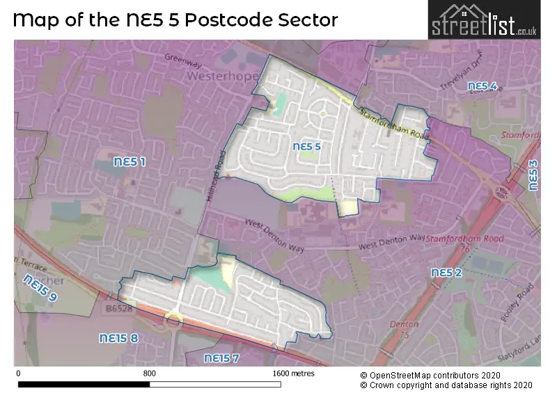
The NE5 5 Postcode shares a border with NE5 2 (NEWCASTLE UPON TYNE, East Denton), NE5 4 (NEWCASTLE UPON TYNE), NE5 1 (NEWCASTLE UPON TYNE, Callerton, Chapel Park), NE15 7 (NEWCASTLE UPON TYNE, Lemington, West Denton) and NE15 8 (NEWCASTLE UPON TYNE, Lemington, Newburn).
Map of the NE5 5 Postcode Sector
Explore the NE5 5 postcode sector by using our interactive map.
The sector is within the post town of NEWCASTLE UPON TYNE.
NE5 5 is a postcode sector within the NE5 postcode district which is within the NE Newcastle upon Tyne postcode area.
The Royal Mail delivery office for the NE5 5 postal sector is the West Delivery Office (ne).
The area of the NE5 5 postcode sector is 0.45 square miles which is 1.16 square kilometres or 287.39 square acres.
The NE5 5 postcode sector is crossed by the A69 Major A road.
Your support helps keep this site running!
If you enjoy using this website, consider buying me a coffee to help cover hosting costs.


| N | E | 5 | - | 5 | X | X |
| N | E | 5 | Space | 5 | Letter | Letter |
Official List of Streets
NEWCASTLE UPON TYNE (66 Streets)
Westerhope (9 Streets)
(2 Streets)
Unofficial Streets or Alternative Spellings
NEWCASTLE UPON TYNE
APPERLEY CHAPEL HOUSE DRIVE DENTON GROVE EDNA TERRACE LILY TERRACE LINHOPE ROAD MARY TERRACE NEWBIGGIN LANE PILTON ROAD RAPPERTON COURT WARWICK ROAD HILL HEAD DRIVE MIDDLE GATE THE FELL WAY WEST DENTON INTERCHANGEEast Denton
SOUTH VIEWPonteland
STAMFORDHAM ROADWeather Forecast for NE5 5
Weather Forecast for Westerhope
| Time Period | Icon | Description | Temperature | Rain Probability | Wind |
|---|---|---|---|---|---|
| 12:00 to 15:00 | Cloudy | 8.0°C (feels like 6.0°C) | 5.00% | SSW 11 mph | |
| 15:00 to 18:00 | Cloudy | 9.0°C (feels like 6.0°C) | 5.00% | SSW 13 mph | |
| 18:00 to 21:00 | Cloudy | 8.0°C (feels like 5.0°C) | 5.00% | SSW 13 mph | |
| 21:00 to 00:00 | Cloudy | 8.0°C (feels like 5.0°C) | 5.00% | S 13 mph |
| Time Period | Icon | Description | Temperature | Rain Probability | Wind |
|---|---|---|---|---|---|
| 00:00 to 03:00 | Cloudy | 8.0°C (feels like 6.0°C) | 5.00% | SSE 9 mph | |
| 03:00 to 06:00 | Cloudy | 8.0°C (feels like 6.0°C) | 5.00% | S 11 mph | |
| 06:00 to 09:00 | Cloudy | 8.0°C (feels like 5.0°C) | 5.00% | SSW 18 mph | |
| 09:00 to 12:00 | Cloudy | 8.0°C (feels like 5.0°C) | 5.00% | SSW 18 mph | |
| 12:00 to 15:00 | Cloudy | 10.0°C (feels like 6.0°C) | 11.00% | SSW 16 mph | |
| 15:00 to 18:00 | Cloudy | 9.0°C (feels like 6.0°C) | 14.00% | SW 13 mph | |
| 18:00 to 21:00 | Clear night | 7.0°C (feels like 4.0°C) | 8.00% | SW 13 mph | |
| 21:00 to 00:00 | Light rain shower (night) | 5.0°C (feels like 2.0°C) | 37.00% | WSW 13 mph |
| Time Period | Icon | Description | Temperature | Rain Probability | Wind |
|---|---|---|---|---|---|
| 00:00 to 03:00 | Clear night | 5.0°C (feels like 0.0°C) | 1.00% | WSW 13 mph | |
| 03:00 to 06:00 | Clear night | 4.0°C (feels like 0.0°C) | 1.00% | WSW 13 mph | |
| 06:00 to 09:00 | Clear night | 4.0°C (feels like 0.0°C) | 2.00% | W 11 mph | |
| 09:00 to 12:00 | Sunny day | 4.0°C (feels like 0.0°C) | 1.00% | WSW 11 mph | |
| 12:00 to 15:00 | Partly cloudy (day) | 6.0°C (feels like 3.0°C) | 0.00% | W 13 mph | |
| 15:00 to 18:00 | Sunny day | 7.0°C (feels like 3.0°C) | 0.00% | W 11 mph | |
| 18:00 to 21:00 | Clear night | 4.0°C (feels like 1.0°C) | 0.00% | W 9 mph | |
| 21:00 to 00:00 | Clear night | 3.0°C (feels like 0.0°C) | 1.00% | W 7 mph |
| Time Period | Icon | Description | Temperature | Rain Probability | Wind |
|---|---|---|---|---|---|
| 00:00 to 03:00 | Clear night | 1.0°C (feels like -1.0°C) | 0.00% | WSW 7 mph | |
| 03:00 to 06:00 | Clear night | 0.0°C (feels like -2.0°C) | 0.00% | WSW 4 mph | |
| 06:00 to 09:00 | Clear night | -1.0°C (feels like -3.0°C) | 1.00% | WSW 4 mph | |
| 09:00 to 12:00 | Sunny day | 0.0°C (feels like -2.0°C) | 1.00% | SW 4 mph | |
| 12:00 to 15:00 | Sunny day | 6.0°C (feels like 5.0°C) | 1.00% | SSE 2 mph | |
| 15:00 to 18:00 | Sunny day | 7.0°C (feels like 6.0°C) | 0.00% | SE 4 mph | |
| 18:00 to 21:00 | Clear night | 2.0°C (feels like 0.0°C) | 0.00% | SE 4 mph | |
| 21:00 to 00:00 | Clear night | 0.0°C (feels like -2.0°C) | 0.00% | S 4 mph |
| Time Period | Icon | Description | Temperature | Rain Probability | Wind |
|---|---|---|---|---|---|
| 00:00 to 03:00 | Clear night | 0.0°C (feels like -3.0°C) | 1.00% | S 4 mph | |
| 03:00 to 06:00 | Clear night | -1.0°C (feels like -3.0°C) | 3.00% | SSW 4 mph | |
| 06:00 to 09:00 | Clear night | -1.0°C (feels like -3.0°C) | 4.00% | SSW 2 mph | |
| 09:00 to 12:00 | Fog | 1.0°C (feels like -1.0°C) | 14.00% | SSW 4 mph | |
| 12:00 to 15:00 | Sunny day | 4.0°C (feels like 3.0°C) | 1.00% | SE 4 mph | |
| 15:00 to 18:00 | Sunny day | 5.0°C (feels like 3.0°C) | 1.00% | ESE 7 mph | |
| 18:00 to 21:00 | Clear night | 1.0°C (feels like -1.0°C) | 1.00% | E 4 mph | |
| 21:00 to 00:00 | Cloudy | 1.0°C (feels like -1.0°C) | 5.00% | SSW 4 mph |
House Prices in the NE5 5 Postcode Sector
| Type of Property | 2018 Average | 2018 Sales | 2017 Average | 2017 Sales | 2016 Average | 2016 Sales | 2015 Average | 2015 Sales |
|---|---|---|---|---|---|---|---|---|
| Detached | £200,117 | 9 | £211,874 | 8 | £215,452 | 27 | £193,806 | 8 |
| Semi-Detached | £131,367 | 54 | £136,338 | 50 | £133,790 | 58 | £126,882 | 41 |
| Terraced | £125,766 | 22 | £132,316 | 35 | £137,249 | 36 | £128,479 | 47 |
| Flats | £69,000 | 2 | £69,500 | 5 | £80,980 | 5 | £66,325 | 6 |
Important Postcodes NE5 5 in the Postcode Sector
NE5 5HH is the postcode for Palatine Beds, Stamfordham Road
| The NE5 5 Sector is within these Local Authorities |
|
|---|---|
| The NE5 5 Sector is within these Counties |
|
| The NE5 5 Sector is within these Water Company Areas |
|