A wide range of spatial data has been analysed to present this overview of the NE49 9 Postcode sector. If you would like anything added, please contact us.
The NE49 9 postcode sector stands on the Northumberland and Cumbria border.
Did you know? According to the 2021 Census, the NE49 9 postcode sector is home to a bustling 2,981 residents!
Given that each sector allows for 400 unique postcode combinations. Letters C, I, K, M, O and V are not allowed in the last two letters of a postcode. With 144 postcodes already in use, this leaves 256 units available.
The largest settlements in the NE49 9 postal code are HALTWHISTLE and Melkridge.
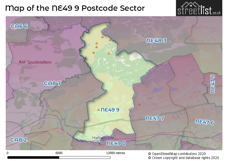
The NE49 9 Postcode shares a border with NE48 3 (Wark, Birtley, Simonburn), NE49 0 (HALTWHISTLE, Coanwood, Melkridge), NE47 7 (Bardon Mill, Henshaw, Redburn) and CA8 7 (Gilsland, Greenhead, Slaggyford).
Map of the NE49 9 Postcode Sector
Explore the NE49 9 postcode sector by using our interactive map.
The sector is within the post town of HALTWHISTLE.
NE49 9 is a postcode sector within the NE49 postcode district which is within the NE Newcastle upon Tyne postcode area.
The Royal Mail delivery office for the NE49 9 postal sector is the Haltwhistle Scale Payment Delivery Office.
The area of the NE49 9 postcode sector is 25.21 square miles which is 65.29 square kilometres or 16,133.70 square acres.
The NE49 9 postcode sector is crossed by the A69 Major A road.
Waterways within the NE49 9 postcode sector include the River South Tyne, Tinalt Burn, Tipalt Burn, Haltwhistle Burn, Caw Burn, Allery Burn, Cundy Burn.
Your support helps keep this site running!
If you enjoy using this website, consider buying me a coffee to help cover hosting costs.


| N | E | 4 | 9 | - | 9 | X | X |
| N | E | 4 | 9 | Space | 9 | Letter | Letter |
Official List of Streets
HALTWHISTLE (82 Streets)
Unofficial Streets or Alternative Spellings
HALTWHISTLE
HADRIANS RISE SCOTSFIELD TERRACE STATION ROAD SYCAMORE STREET TOWN HALL CRESCENT WOODBINE TERRACE WYDON AVENUE WYDON TERRACE BACK BACKS TERRACE BANKS TERRACE (BACK) COMBHILL TERRACE EDENS LAWN FAIRHILL FLEMMING COURT GREENHOLME GREENHOLME CLOSE MEADOW GRANGE (LOWER) MEADOW GRANGE (UPPER) MEADOW PK MEADOW VIEW (LOWER) MEADOW VIEW (UPPER) MILITARY ROAD PLENMELLER ROAD ROMAN MILITARY WAY SCOTCHCOULTHARD DRIVE ST JAMES LANE WYNDON LANEWeather Forecast for NE49 9
Weather Forecast for Once Brewed Youth Hostel
| Time Period | Icon | Description | Temperature | Rain Probability | Wind |
|---|---|---|---|---|---|
| 06:00 to 09:00 | Partly cloudy (night) | 5.0°C (feels like 1.0°C) | 6.00% | WSW 11 mph | |
| 09:00 to 12:00 | Cloudy | 6.0°C (feels like 2.0°C) | 5.00% | SW 13 mph | |
| 12:00 to 15:00 | Cloudy | 7.0°C (feels like 3.0°C) | 8.00% | SW 18 mph | |
| 15:00 to 18:00 | Cloudy | 7.0°C (feels like 3.0°C) | 9.00% | SW 16 mph | |
| 18:00 to 21:00 | Cloudy | 7.0°C (feels like 3.0°C) | 5.00% | SW 16 mph | |
| 21:00 to 00:00 | Cloudy | 7.0°C (feels like 3.0°C) | 7.00% | SW 18 mph |
| Time Period | Icon | Description | Temperature | Rain Probability | Wind |
|---|---|---|---|---|---|
| 00:00 to 03:00 | Cloudy | 7.0°C (feels like 3.0°C) | 7.00% | SW 22 mph | |
| 03:00 to 06:00 | Cloudy | 7.0°C (feels like 3.0°C) | 51.00% | SSW 22 mph | |
| 06:00 to 09:00 | Light rain shower (night) | 7.0°C (feels like 3.0°C) | 45.00% | SSW 22 mph | |
| 09:00 to 12:00 | Light rain | 7.0°C (feels like 3.0°C) | 55.00% | SSW 18 mph | |
| 12:00 to 15:00 | Heavy rain | 8.0°C (feels like 4.0°C) | 87.00% | SSW 16 mph | |
| 15:00 to 18:00 | Heavy rain | 7.0°C (feels like 3.0°C) | 76.00% | WSW 13 mph | |
| 18:00 to 21:00 | Cloudy | 6.0°C (feels like 2.0°C) | 39.00% | WSW 13 mph | |
| 21:00 to 00:00 | Cloudy | 5.0°C (feels like 0.0°C) | 12.00% | WSW 16 mph |
| Time Period | Icon | Description | Temperature | Rain Probability | Wind |
|---|---|---|---|---|---|
| 00:00 to 03:00 | Cloudy | 4.0°C (feels like -1.0°C) | 7.00% | WSW 16 mph | |
| 03:00 to 06:00 | Cloudy | 3.0°C (feels like -2.0°C) | 7.00% | WSW 16 mph | |
| 06:00 to 09:00 | Cloudy | 3.0°C (feels like -2.0°C) | 5.00% | WSW 13 mph | |
| 09:00 to 12:00 | Cloudy | 3.0°C (feels like -1.0°C) | 5.00% | WSW 11 mph | |
| 12:00 to 15:00 | Partly cloudy (day) | 5.0°C (feels like 1.0°C) | 2.00% | WSW 11 mph | |
| 15:00 to 18:00 | Sunny day | 5.0°C (feels like 2.0°C) | 1.00% | WSW 11 mph | |
| 18:00 to 21:00 | Clear night | 3.0°C (feels like 0.0°C) | 1.00% | WSW 9 mph | |
| 21:00 to 00:00 | Clear night | 2.0°C (feels like -1.0°C) | 2.00% | WSW 7 mph |
| Time Period | Icon | Description | Temperature | Rain Probability | Wind |
|---|---|---|---|---|---|
| 00:00 to 03:00 | Clear night | 1.0°C (feels like -1.0°C) | 1.00% | SW 4 mph | |
| 03:00 to 06:00 | Clear night | 0.0°C (feels like -2.0°C) | 3.00% | SW 4 mph | |
| 06:00 to 09:00 | Clear night | -1.0°C (feels like -2.0°C) | 4.00% | SW 2 mph | |
| 09:00 to 12:00 | Sunny day | 1.0°C (feels like -1.0°C) | 1.00% | SW 2 mph | |
| 12:00 to 15:00 | Sunny day | 6.0°C (feels like 5.0°C) | 0.00% | ESE 2 mph | |
| 15:00 to 18:00 | Sunny day | 6.0°C (feels like 5.0°C) | 0.00% | SE 4 mph | |
| 18:00 to 21:00 | Clear night | 1.0°C (feels like -1.0°C) | 0.00% | ESE 4 mph | |
| 21:00 to 00:00 | Clear night | -1.0°C (feels like -3.0°C) | 0.00% | ESE 4 mph |
| Time Period | Icon | Description | Temperature | Rain Probability | Wind |
|---|---|---|---|---|---|
| 00:00 to 03:00 | Clear night | -1.0°C (feels like -4.0°C) | 2.00% | ESE 4 mph | |
| 03:00 to 06:00 | Clear night | -1.0°C (feels like -4.0°C) | 4.00% | ESE 4 mph | |
| 06:00 to 09:00 | Clear night | -2.0°C (feels like -4.0°C) | 4.00% | ESE 4 mph | |
| 09:00 to 12:00 | Sunny day | 0.0°C (feels like -2.0°C) | 2.00% | E 4 mph | |
| 12:00 to 15:00 | Sunny day | 4.0°C (feels like 2.0°C) | 1.00% | ESE 7 mph | |
| 15:00 to 18:00 | Sunny day | 5.0°C (feels like 2.0°C) | 1.00% | ESE 7 mph | |
| 18:00 to 21:00 | Clear night | 0.0°C (feels like -2.0°C) | 1.00% | ESE 4 mph | |
| 21:00 to 00:00 | Clear night | 0.0°C (feels like -3.0°C) | 3.00% | ESE 4 mph |
Schools and Places of Education Within the NE49 9 Postcode Sector
Haltwhistle Primary Academy
Academy sponsor led
Park Avenue, Haltwhistle, , NE49 9BA
Head: Mrs Susie Drake
Ofsted Rating: Outstanding
Inspection: 2023-02-15 (719 days ago)
Website: Visit Haltwhistle Primary Academy Website
Phone: 01434320467
Number of Pupils: 244
House Prices in the NE49 9 Postcode Sector
| Type of Property | 2018 Average | 2018 Sales | 2017 Average | 2017 Sales | 2016 Average | 2016 Sales | 2015 Average | 2015 Sales |
|---|---|---|---|---|---|---|---|---|
| Detached | £230,000 | 5 | £190,305 | 7 | £182,906 | 11 | £192,178 | 5 |
| Semi-Detached | £120,313 | 12 | £133,255 | 15 | £125,748 | 15 | £151,818 | 11 |
| Terraced | £88,983 | 14 | £104,375 | 16 | £112,856 | 21 | £81,845 | 10 |
| Flats | £56,875 | 4 | £70,500 | 4 | £0 | 0 | £71,650 | 3 |
Important Postcodes NE49 9 in the Postcode Sector
NE49 9AJ is the postcode for Greencroft Lodge, Westgate, and Northumbria Healthcare NHS Foundation Trust, Haltwhistle War Memorial Hospital
NE49 9AP is the postcode for Haltwhistle Health Centre, Greencroft Avenue
NE49 9BA is the postcode for Haltwhistle Middle Academy, Park Avenue, Haltwhistle South Tynedale County Middle School, Park Avenue, Haltwhistle Primary Academy, Park Avenue, and PLSU, Haltwhistle Middle Academy, Park Avenue
NE49 9DP is the postcode for Haltwhistle County First School, Woodhead Lane, Greenholme Aged Persons Home, Woodhead Lane, and Haltwhistle First Academy, Woodhead Lane
| The NE49 9 Sector is within these Local Authorities |
|
|---|---|
| The NE49 9 Sector is within these Counties |
|
| The NE49 9 Sector is within these Water Company Areas |
|