A wide range of spatial data has been analysed to present this overview of the NE49 0 Postcode sector. If you would like anything added, please contact us.
The NE49 0 postcode sector is within the county of Northumberland.
Did you know? According to the 2021 Census, the NE49 0 postcode sector is home to a bustling 1,241 residents!
Given that each sector allows for 400 unique postcode combinations. Letters C, I, K, M, O and V are not allowed in the last two letters of a postcode. With 140 postcodes already in use, this leaves 260 units available.
The largest settlement in the NE49 0 postal code is HALTWHISTLE followed by Coanwood, and Melkridge.
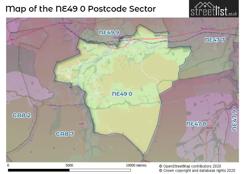
The NE49 0 Postcode shares a border with NE47 8 (Whitfield, Carrshield, Ninebanks), NE49 9 (HALTWHISTLE, Melkridge), NE47 7 (Bardon Mill, Henshaw, Redburn) and CA8 7 (Gilsland, Greenhead, Slaggyford).
Map of the NE49 0 Postcode Sector
Explore the NE49 0 postcode sector by using our interactive map.
The sector is within the post town of HALTWHISTLE.
NE49 0 is a postcode sector within the NE49 postcode district which is within the NE Newcastle upon Tyne postcode area.
The Royal Mail delivery office for the NE49 0 postal sector is the Haltwhistle Scale Payment Delivery Office.
The area of the NE49 0 postcode sector is 24.03 square miles which is 62.24 square kilometres or 15,380.25 square acres.
The NE49 0 postcode sector is crossed by the A69 Major A road.
Waterways within the NE49 0 postcode sector include the River South Tyne, Tinalt Burn, Blaeberry Burn, Kingswood Burn, Black Cleugh, Haltwhistle Burn, Cundy Burn, Hartley Burn.
Your support helps keep this site running!
If you enjoy using this website, consider buying me a coffee to help cover hosting costs.


| N | E | 4 | 9 | - | 0 | X | X |
| N | E | 4 | 9 | Space | 0 | Letter | Letter |
Official List of Streets
HALTWHISTLE (38 Streets)
(20 Streets)
Park Village (1 Streets)
Plenmeller (3 Streets)
Coanwood (2 Streets)
Unofficial Streets or Alternative Spellings
HALTWHISTLE
FAIR HILL MILL LANE PARK ROAD SHEPHERD TERRACE SHIELD HILL THE MART TYNE VIEW ROAD WEST ROADWeather Forecast for NE49 0
Weather Forecast for Rowfoot
| Time Period | Icon | Description | Temperature | Rain Probability | Wind |
|---|---|---|---|---|---|
| 21:00 to 00:00 | Cloudy | 5.0°C (feels like 2.0°C) | 9.00% | SSW 11 mph |
| Time Period | Icon | Description | Temperature | Rain Probability | Wind |
|---|---|---|---|---|---|
| 00:00 to 03:00 | Overcast | 5.0°C (feels like 2.0°C) | 12.00% | SSW 11 mph | |
| 03:00 to 06:00 | Cloudy | 5.0°C (feels like 2.0°C) | 5.00% | SW 9 mph | |
| 06:00 to 09:00 | Cloudy | 5.0°C (feels like 1.0°C) | 4.00% | SSW 16 mph | |
| 09:00 to 12:00 | Cloudy | 5.0°C (feels like 1.0°C) | 5.00% | SSW 16 mph | |
| 12:00 to 15:00 | Cloudy | 7.0°C (feels like 3.0°C) | 5.00% | SSW 18 mph | |
| 15:00 to 18:00 | Cloudy | 7.0°C (feels like 3.0°C) | 5.00% | SSW 18 mph | |
| 18:00 to 21:00 | Cloudy | 7.0°C (feels like 3.0°C) | 5.00% | SSW 16 mph | |
| 21:00 to 00:00 | Cloudy | 7.0°C (feels like 3.0°C) | 5.00% | SSW 20 mph |
| Time Period | Icon | Description | Temperature | Rain Probability | Wind |
|---|---|---|---|---|---|
| 00:00 to 03:00 | Cloudy | 7.0°C (feels like 3.0°C) | 5.00% | SSW 18 mph | |
| 03:00 to 06:00 | Light rain | 7.0°C (feels like 3.0°C) | 53.00% | SSW 20 mph | |
| 06:00 to 09:00 | Heavy rain | 7.0°C (feels like 3.0°C) | 75.00% | SSW 22 mph | |
| 09:00 to 12:00 | Light rain | 8.0°C (feels like 3.0°C) | 51.00% | SSW 20 mph | |
| 12:00 to 15:00 | Light rain | 8.0°C (feels like 5.0°C) | 50.00% | SW 18 mph | |
| 15:00 to 18:00 | Light rain shower (day) | 8.0°C (feels like 4.0°C) | 37.00% | SW 16 mph | |
| 18:00 to 21:00 | Partly cloudy (night) | 6.0°C (feels like 2.0°C) | 8.00% | WSW 13 mph | |
| 21:00 to 00:00 | Partly cloudy (night) | 5.0°C (feels like 1.0°C) | 8.00% | WSW 13 mph |
| Time Period | Icon | Description | Temperature | Rain Probability | Wind |
|---|---|---|---|---|---|
| 00:00 to 03:00 | Partly cloudy (night) | 4.0°C (feels like -1.0°C) | 6.00% | WSW 16 mph | |
| 03:00 to 06:00 | Partly cloudy (night) | 3.0°C (feels like -1.0°C) | 3.00% | WSW 16 mph | |
| 06:00 to 09:00 | Partly cloudy (night) | 3.0°C (feels like -2.0°C) | 2.00% | WSW 13 mph | |
| 09:00 to 12:00 | Partly cloudy (day) | 3.0°C (feels like -1.0°C) | 1.00% | WSW 11 mph | |
| 12:00 to 15:00 | Cloudy | 5.0°C (feels like 1.0°C) | 3.00% | WSW 13 mph | |
| 15:00 to 18:00 | Sunny day | 6.0°C (feels like 2.0°C) | 1.00% | WSW 13 mph | |
| 18:00 to 21:00 | Clear night | 4.0°C (feels like 0.0°C) | 3.00% | WSW 11 mph | |
| 21:00 to 00:00 | Clear night | 3.0°C (feels like 0.0°C) | 1.00% | WSW 9 mph |
| Time Period | Icon | Description | Temperature | Rain Probability | Wind |
|---|---|---|---|---|---|
| 00:00 to 03:00 | Clear night | 2.0°C (feels like -1.0°C) | 1.00% | WSW 7 mph | |
| 03:00 to 06:00 | Clear night | 1.0°C (feels like -1.0°C) | 2.00% | SW 4 mph | |
| 06:00 to 09:00 | Clear night | 0.0°C (feels like -2.0°C) | 2.00% | SW 4 mph | |
| 09:00 to 12:00 | Sunny day | 1.0°C (feels like 0.0°C) | 4.00% | WSW 2 mph | |
| 12:00 to 15:00 | Sunny day | 6.0°C (feels like 5.0°C) | 1.00% | SSW 4 mph | |
| 15:00 to 18:00 | Sunny day | 7.0°C (feels like 5.0°C) | 1.00% | SSE 4 mph | |
| 18:00 to 21:00 | Clear night | 1.0°C (feels like -1.0°C) | 1.00% | SE 4 mph | |
| 21:00 to 00:00 | Clear night | 0.0°C (feels like -3.0°C) | 1.00% | SSE 4 mph |
House Prices in the NE49 0 Postcode Sector
| Type of Property | 2018 Average | 2018 Sales | 2017 Average | 2017 Sales | 2016 Average | 2016 Sales | 2015 Average | 2015 Sales |
|---|---|---|---|---|---|---|---|---|
| Detached | £260,000 | 2 | £281,333 | 6 | £251,250 | 2 | £180,167 | 3 |
| Semi-Detached | £125,033 | 3 | £154,000 | 3 | £140,750 | 4 | £142,500 | 2 |
| Terraced | £104,583 | 6 | £123,857 | 7 | £123,833 | 9 | £116,375 | 12 |
| Flats | £51,000 | 1 | £95,250 | 1 | £55,000 | 1 | £0 | 0 |
Important Postcodes NE49 0 in the Postcode Sector
NE49 0AX is the postcode for Northumberland County Council, Haltwhistle Library Mechanics Institute, Westgate
| The NE49 0 Sector is within these Local Authorities |
|
|---|---|
| The NE49 0 Sector is within these Counties |
|
| The NE49 0 Sector is within these Water Company Areas |
|