A wide range of spatial data has been analysed to present this overview of the NE47 9 Postcode sector. If you would like anything added, please contact us.
The NE47 9 Allendale Town Postcode Sector
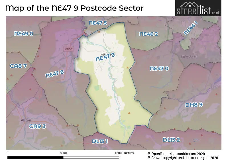
The NE47 9 postcode sector stands on the Durham and Northumberland border.
Did you know? According to the 2021 Census, the NE47 9 postcode sector is home to a bustling 1,961 residents!
Given that each sector allows for 400 unique postcode combinations. Letters C, I, K, M, O and V are not allowed in the last two letters of a postcode. With 184 postcodes already in use, this leaves 216 units available.
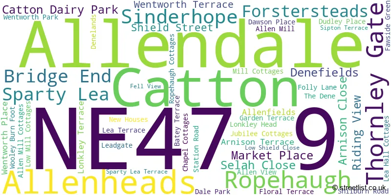
The largest settlement in the NE47 9 postal code is Allendale followed by Catton, and Allenheads.
The NE47 9 Postcode shares a border with NE46 2 (HEXHAM), NE47 8 (Whitfield, Carrshield, Ninebanks), DH8 9 (CONSETT, Blanchland, Castleside), DL13 1 (Westgate, St. Johns Chapel, Wearhead), DL13 2 (Stanhope, Frosterley, Rookhope), NE47 0 (Slaley, Steel, Low Juniper) and NE47 5 (Newbrough, Fourstones, Langley-on-Tyne).
Map of the NE47 9 Postcode Sector
Explore the NE47 9 postcode sector by using our interactive map.
The sector is within the post town of HEXHAM.
NE47 9 is a postcode sector within the NE47 postcode district which is within the NE Newcastle upon Tyne postcode area.
The Royal Mail delivery office for the NE47 9 postal sector is the Hexham Delivery Office.
The area of the NE47 9 postcode sector is 42.32 square miles which is 109.61 square kilometres or 27,085.48 square acres.
Waterways within the NE47 9 postcode sector include the Beldon Burn, Swinhope Burn, Acton Burn, East Allen, West Allen, Oakey Dean.
Your support helps keep this site running!
If you enjoy using this website, consider buying me a coffee to help cover hosting costs.

| N | E | 4 | 7 | - | 9 | X | X |
| N | E | 4 | 7 | Space | 9 | Letter | Letter |
Official List of Streets
Allendale (27 Streets)
Catton (5 Streets)
(19 Streets)
Allenheads (7 Streets)
Sparty Lea (4 Streets)
Ropehaugh (2 Streets)
Unofficial Streets or Alternative Spellings
Weather Forecast for NE47 9
Weather Forecast for Sinderhope
| Time Period | Icon | Description | Temperature | Rain Probability | Wind |
|---|---|---|---|---|---|
| 21:00 to 00:00 | Cloudy | 2.0°C (feels like -1.0°C) | 12.00% | SSE 7 mph |
| Time Period | Icon | Description | Temperature | Rain Probability | Wind |
|---|---|---|---|---|---|
| 00:00 to 03:00 | Heavy rain | 6.0°C (feels like 1.0°C) | 82.00% | S 18 mph | |
| 03:00 to 06:00 | Mist | 7.0°C (feels like 3.0°C) | 42.00% | S 20 mph | |
| 06:00 to 09:00 | Fog | 8.0°C (feels like 4.0°C) | 29.00% | S 16 mph | |
| 09:00 to 12:00 | Heavy rain shower (day) | 10.0°C (feels like 6.0°C) | 63.00% | S 18 mph | |
| 12:00 to 15:00 | Heavy rain | 11.0°C (feels like 7.0°C) | 83.00% | SSW 25 mph | |
| 15:00 to 18:00 | Partly cloudy (day) | 9.0°C (feels like 5.0°C) | 36.00% | SW 20 mph | |
| 18:00 to 21:00 | Partly cloudy (night) | 7.0°C (feels like 3.0°C) | 9.00% | SW 18 mph | |
| 21:00 to 00:00 | Partly cloudy (night) | 7.0°C (feels like 3.0°C) | 4.00% | SW 18 mph |
| Time Period | Icon | Description | Temperature | Rain Probability | Wind |
|---|---|---|---|---|---|
| 00:00 to 03:00 | Cloudy | 8.0°C (feels like 4.0°C) | 6.00% | SSW 16 mph | |
| 03:00 to 06:00 | Cloudy | 8.0°C (feels like 4.0°C) | 6.00% | S 16 mph | |
| 06:00 to 09:00 | Fog | 8.0°C (feels like 5.0°C) | 25.00% | S 18 mph | |
| 09:00 to 12:00 | Light rain | 10.0°C (feels like 6.0°C) | 55.00% | S 22 mph | |
| 12:00 to 15:00 | Heavy rain | 10.0°C (feels like 6.0°C) | 75.00% | S 27 mph | |
| 15:00 to 18:00 | Light rain | 10.0°C (feels like 6.0°C) | 56.00% | SSW 25 mph | |
| 18:00 to 21:00 | Light rain shower (night) | 9.0°C (feels like 5.0°C) | 35.00% | SSW 20 mph | |
| 21:00 to 00:00 | Cloudy | 7.0°C (feels like 3.0°C) | 9.00% | SSW 18 mph |
| Time Period | Icon | Description | Temperature | Rain Probability | Wind |
|---|---|---|---|---|---|
| 00:00 to 03:00 | Mist | 7.0°C (feels like 3.0°C) | 13.00% | SW 16 mph | |
| 03:00 to 06:00 | Mist | 6.0°C (feels like 2.0°C) | 13.00% | SW 13 mph | |
| 06:00 to 09:00 | Mist | 6.0°C (feels like 2.0°C) | 13.00% | SW 13 mph | |
| 09:00 to 12:00 | Mist | 6.0°C (feels like 3.0°C) | 13.00% | SW 13 mph | |
| 12:00 to 15:00 | Sunny day | 8.0°C (feels like 4.0°C) | 4.00% | SW 16 mph | |
| 15:00 to 18:00 | Sunny day | 8.0°C (feels like 5.0°C) | 3.00% | SW 16 mph | |
| 18:00 to 21:00 | Partly cloudy (night) | 6.0°C (feels like 2.0°C) | 1.00% | SW 11 mph | |
| 21:00 to 00:00 | Mist | 5.0°C (feels like 2.0°C) | 11.00% | SW 11 mph |
| Time Period | Icon | Description | Temperature | Rain Probability | Wind |
|---|---|---|---|---|---|
| 00:00 to 03:00 | Mist | 5.0°C (feels like 1.0°C) | 15.00% | SSW 13 mph | |
| 03:00 to 06:00 | Mist | 5.0°C (feels like 1.0°C) | 18.00% | SSW 18 mph | |
| 06:00 to 09:00 | Cloudy | 6.0°C (feels like 1.0°C) | 18.00% | SSW 22 mph | |
| 09:00 to 12:00 | Heavy rain | 7.0°C (feels like 2.0°C) | 76.00% | SSW 25 mph | |
| 12:00 to 15:00 | Heavy rain | 8.0°C (feels like 4.0°C) | 82.00% | SSW 27 mph | |
| 15:00 to 18:00 | Heavy rain | 9.0°C (feels like 4.0°C) | 85.00% | SSW 27 mph | |
| 18:00 to 21:00 | Heavy rain | 8.0°C (feels like 4.0°C) | 83.00% | SW 25 mph | |
| 21:00 to 00:00 | Light rain | 8.0°C (feels like 3.0°C) | 59.00% | SW 22 mph |
Schools and Places of Education Within the NE47 9 Postcode Sector
Allendale Primary School
Community school
, Allendale, Northumberland, NE47 9PS
Head: Mrs Alison Hawkins
Ofsted Rating: Good
Inspection: 2023-11-15 (462 days ago)
Website: Visit Allendale Primary School Website
Phone: 01434683376
Number of Pupils: 126
House Prices in the NE47 9 Postcode Sector
| Type of Property | 2018 Average | 2018 Sales | 2017 Average | 2017 Sales | 2016 Average | 2016 Sales | 2015 Average | 2015 Sales |
|---|---|---|---|---|---|---|---|---|
| Detached | £347,611 | 18 | £279,167 | 9 | £233,813 | 12 | £295,423 | 18 |
| Semi-Detached | £200,323 | 8 | £189,977 | 11 | £200,378 | 9 | £173,000 | 5 |
| Terraced | £169,214 | 7 | £153,000 | 10 | £153,545 | 11 | £164,247 | 16 |
| Flats | £0 | 0 | £0 | 0 | £70,000 | 1 | £0 | 0 |
Important Postcodes NE47 9 in the Postcode Sector
NE47 9PS is the postcode for Allendale Primary School, B6303 Allendale Main Road, Allendale Primary School, Allendale, SPORTS HALL, Allendale Primary School, Allendale, and Allendale Middle School, Allendale
NE47 9PT is the postcode for Allendale First School, Allendale, and Allendale Primary School, Allendale
| The NE47 9 Sector is within these Local Authorities |
|
|---|---|
| The NE47 9 Sector is within these Counties |
|
| The NE47 9 Sector is within these Water Company Areas |
|