A wide range of spatial data has been analysed to present this overview of the NE47 0 Postcode sector. If you would like anything added, please contact us.
The NE47 0 Slaley Postcode Sector
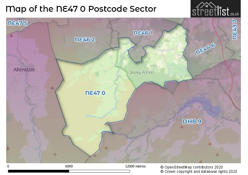
The NE47 0 postcode sector stands on the Durham and Northumberland border.
Did you know? According to the 2021 Census, the NE47 0 postcode sector is home to a bustling 907 residents!
Given that each sector allows for 400 unique postcode combinations. Letters C, I, K, M, O and V are not allowed in the last two letters of a postcode. With 70 postcodes already in use, this leaves 330 units available.
The largest settlement in the NE47 0 postal code is Slaley followed by Steel, and Low Juniper.
The NE47 0 Postcode shares a border with NE46 2 (HEXHAM), NE47 9 (Allendale, Catton, Allenheads), DH8 9 (CONSETT, Blanchland, Castleside), NE44 6 (RIDING MILL, Broomhaugh, Healey) and NE46 1 (HEXHAM, Woodland Rise, Fellside).
Map of the NE47 0 Postcode Sector
Explore the NE47 0 postcode sector by using our interactive map.
The sector is within the post town of HEXHAM.
NE47 0 is a postcode sector within the NE47 postcode district which is within the NE Newcastle upon Tyne postcode area.
The Royal Mail delivery office for the NE47 0 postal sector is the Hexham Delivery Office.
The area of the NE47 0 postcode sector is 30.67 square miles which is 79.44 square kilometres or 19,630.66 square acres.
Waterways within the NE47 0 postcode sector include the Devil's Water, Beldon Burn.
Your support helps keep this site running!
If you enjoy using this website, consider buying me a coffee to help cover hosting costs.

| N | E | 4 | 7 | - | 0 | X | X |
| N | E | 4 | 7 | Space | 0 | Letter | Letter |
Official List of Streets
(8 Streets)
Slaley (6 Streets)
Steel (2 Streets)
Unofficial Streets or Alternative Spellings
Weather Forecast for NE47 0
Weather Forecast for Steel
| Time Period | Icon | Description | Temperature | Rain Probability | Wind |
|---|---|---|---|---|---|
| 12:00 to 15:00 | Cloudy | 1.0°C (feels like -4.0°C) | 7.00% | SSE 18 mph | |
| 15:00 to 18:00 | Cloudy | 4.0°C (feels like 1.0°C) | 14.00% | SE 7 mph | |
| 18:00 to 21:00 | Mist | 2.0°C (feels like 0.0°C) | 15.00% | ESE 4 mph | |
| 21:00 to 00:00 | Cloudy | 2.0°C (feels like -2.0°C) | 19.00% | SE 7 mph |
| Time Period | Icon | Description | Temperature | Rain Probability | Wind |
|---|---|---|---|---|---|
| 00:00 to 03:00 | Light rain | 5.0°C (feels like 1.0°C) | 80.00% | S 16 mph | |
| 03:00 to 06:00 | Cloudy | 7.0°C (feels like 3.0°C) | 42.00% | S 20 mph | |
| 06:00 to 09:00 | Cloudy | 8.0°C (feels like 4.0°C) | 27.00% | S 18 mph | |
| 09:00 to 12:00 | Light rain | 10.0°C (feels like 6.0°C) | 53.00% | S 18 mph | |
| 12:00 to 15:00 | Heavy rain | 12.0°C (feels like 8.0°C) | 82.00% | SSW 27 mph | |
| 15:00 to 18:00 | Partly cloudy (day) | 10.0°C (feels like 6.0°C) | 37.00% | SW 25 mph | |
| 18:00 to 21:00 | Clear night | 8.0°C (feels like 4.0°C) | 9.00% | SW 20 mph | |
| 21:00 to 00:00 | Cloudy | 8.0°C (feels like 4.0°C) | 5.00% | SW 20 mph |
| Time Period | Icon | Description | Temperature | Rain Probability | Wind |
|---|---|---|---|---|---|
| 00:00 to 03:00 | Cloudy | 8.0°C (feels like 5.0°C) | 5.00% | SSW 18 mph | |
| 03:00 to 06:00 | Cloudy | 9.0°C (feels like 5.0°C) | 9.00% | S 16 mph | |
| 06:00 to 09:00 | Cloudy | 9.0°C (feels like 6.0°C) | 20.00% | S 16 mph | |
| 09:00 to 12:00 | Light rain | 11.0°C (feels like 7.0°C) | 55.00% | S 18 mph | |
| 12:00 to 15:00 | Heavy rain | 12.0°C (feels like 8.0°C) | 75.00% | S 25 mph | |
| 15:00 to 18:00 | Light rain | 12.0°C (feels like 8.0°C) | 55.00% | SSW 22 mph | |
| 18:00 to 21:00 | Cloudy | 10.0°C (feels like 7.0°C) | 17.00% | SSW 20 mph | |
| 21:00 to 00:00 | Cloudy | 9.0°C (feels like 5.0°C) | 8.00% | SW 18 mph |
| Time Period | Icon | Description | Temperature | Rain Probability | Wind |
|---|---|---|---|---|---|
| 00:00 to 03:00 | Cloudy | 8.0°C (feels like 4.0°C) | 5.00% | SW 16 mph | |
| 03:00 to 06:00 | Cloudy | 7.0°C (feels like 4.0°C) | 5.00% | SW 13 mph | |
| 06:00 to 09:00 | Cloudy | 7.0°C (feels like 4.0°C) | 5.00% | SW 13 mph | |
| 09:00 to 12:00 | Cloudy | 8.0°C (feels like 5.0°C) | 5.00% | SW 13 mph | |
| 12:00 to 15:00 | Sunny day | 9.0°C (feels like 6.0°C) | 4.00% | SW 16 mph | |
| 15:00 to 18:00 | Sunny day | 9.0°C (feels like 6.0°C) | 3.00% | SW 13 mph | |
| 18:00 to 21:00 | Clear night | 7.0°C (feels like 4.0°C) | 1.00% | SW 11 mph | |
| 21:00 to 00:00 | Clear night | 6.0°C (feels like 3.0°C) | 1.00% | SW 11 mph |
| Time Period | Icon | Description | Temperature | Rain Probability | Wind |
|---|---|---|---|---|---|
| 00:00 to 03:00 | Overcast | 6.0°C (feels like 3.0°C) | 10.00% | SSW 13 mph | |
| 03:00 to 06:00 | Cloudy | 6.0°C (feels like 2.0°C) | 11.00% | SSW 16 mph | |
| 06:00 to 09:00 | Cloudy | 7.0°C (feels like 3.0°C) | 18.00% | S 20 mph | |
| 09:00 to 12:00 | Heavy rain | 8.0°C (feels like 3.0°C) | 76.00% | SSW 25 mph | |
| 12:00 to 15:00 | Heavy rain | 9.0°C (feels like 5.0°C) | 83.00% | SSW 27 mph | |
| 15:00 to 18:00 | Heavy rain | 10.0°C (feels like 6.0°C) | 85.00% | SSW 25 mph | |
| 18:00 to 21:00 | Heavy rain | 9.0°C (feels like 5.0°C) | 82.00% | SW 22 mph | |
| 21:00 to 00:00 | Light rain | 9.0°C (feels like 4.0°C) | 58.00% | SW 22 mph |
Schools and Places of Education Within the NE47 0 Postcode Sector
Slaley First School
Community school
Slaley Village, , Northumberland, NE47 0AA
Head: Mrs Angela Louise Hayward
Ofsted Rating: Good
Inspection: 2019-01-23 (2219 days ago)
Website: Visit Slaley First School Website
Phone: 01434673220
Number of Pupils: 48
Whitley Chapel Church of England First School
Voluntary aided school
Leazes Lane, Hexham, Northumberland, NE47 0HB
Head: Mrs Karen North
Ofsted Rating: Good
Inspection: 2018-07-04 (2422 days ago)
Website: Visit Whitley Chapel Church of England First School Website
Phone: 01434673294
Number of Pupils: 43
House Prices in the NE47 0 Postcode Sector
| Type of Property | 2018 Average | 2018 Sales | 2017 Average | 2017 Sales | 2016 Average | 2016 Sales | 2015 Average | 2015 Sales |
|---|---|---|---|---|---|---|---|---|
| Detached | £439,667 | 9 | £522,800 | 5 | £348,524 | 11 | £399,250 | 2 |
| Semi-Detached | £231,750 | 4 | £213,000 | 2 | £200,000 | 2 | £237,500 | 2 |
| Terraced | £39,000 | 1 | £37,500 | 1 | £0 | 0 | £208,000 | 2 |
| Flats | £0 | 0 | £0 | 0 | £0 | 0 | £0 | 0 |
Important Postcodes NE47 0 in the Postcode Sector
NE47 0HB is the postcode for Whitley Chapel School, Steel
| The NE47 0 Sector is within these Local Authorities |
|
|---|---|
| The NE47 0 Sector is within these Counties |
|
| The NE47 0 Sector is within these Water Company Areas |
|