A wide range of spatial data has been analysed to present this overview of the NE34 0 Postcode sector. If you would like anything added, please contact us.
The NE34 0 postcode sector is within the county of Tyne & Wear.
Did you know? According to the 2021 Census, the NE34 0 postcode sector is home to a bustling 9,900 residents!
Given that each sector allows for 400 unique postcode combinations. Letters C, I, K, M, O and V are not allowed in the last two letters of a postcode. With 215 postcodes already in use, this leaves 185 units available.
The NE34 0 postal code covers the settlement of SOUTH SHIELDS.
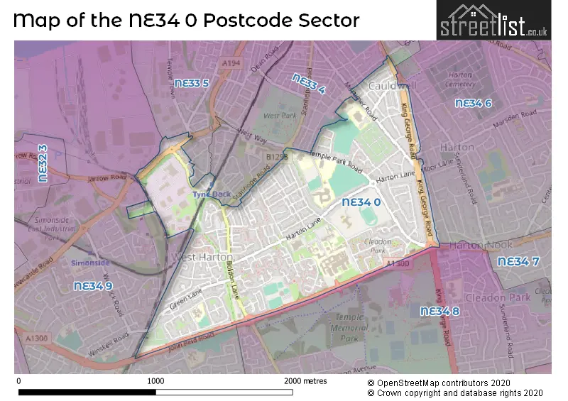
The NE34 0 Postcode shares a border with NE33 3 (SOUTH SHIELDS), NE33 4 (SOUTH SHIELDS), NE33 5 (SOUTH SHIELDS), NE34 8 (SOUTH SHIELDS), NE34 9 (SOUTH SHIELDS) and NE34 6 (SOUTH SHIELDS).
Map of the NE34 0 Postcode Sector
Explore the NE34 0 postcode sector by using our interactive map.
The sector is within the post town of SOUTH SHIELDS.
NE34 0 is a postcode sector within the NE34 postcode district which is within the NE Newcastle upon Tyne postcode area.
The Royal Mail delivery office for the NE34 0 postal sector is the South Shields Delivery Office.
The area of the NE34 0 postcode sector is 0.91 square miles which is 2.36 square kilometres or 583.20 square acres.
Your support helps keep this site running!
If you enjoy using this website, consider buying me a coffee to help cover hosting costs.

| N | E | 3 | 4 | - | 0 | X | X |
| N | E | 3 | 4 | Space | 0 | Letter | Letter |
Official List of Streets
SOUTH SHIELDS (127 Streets)
Middlefields Industrial Estate (2 Streets)
Unofficial Streets or Alternative Spellings
SOUTH SHIELDS
BIRCHINGTON AVENUE CHESTERTON ROAD GROSVENOR ROAD HARTON GROVE HOLMFIELD AVENUE JOHN REID ROAD LASCELLES AVENUE LORD NELSON STREET MOOR LANE NAPIER STREET PRINCE EDWARD ROAD PRINCE OF WALES CLOSE READING ROAD STANHOPE ROAD WHITEHEAD STREET HOPE STREET JARROW ROAD JOHN REID ROAD CYCLE ROUTE SAINT PETERS AVENUE SCHOOL LOANING ST PETERS AVENUE WATLING STREET WESTERN APPROACHWeather Forecast for NE34 0
Weather Forecast for Horsley Hill
| Time Period | Icon | Description | Temperature | Rain Probability | Wind |
|---|---|---|---|---|---|
| 21:00 to 00:00 | Cloudy | 8.0°C (feels like 4.0°C) | 5.00% | S 13 mph |
| Time Period | Icon | Description | Temperature | Rain Probability | Wind |
|---|---|---|---|---|---|
| 00:00 to 03:00 | Cloudy | 7.0°C (feels like 4.0°C) | 5.00% | S 16 mph | |
| 03:00 to 06:00 | Cloudy | 8.0°C (feels like 5.0°C) | 5.00% | S 13 mph | |
| 06:00 to 09:00 | Cloudy | 8.0°C (feels like 5.0°C) | 5.00% | SSW 16 mph | |
| 09:00 to 12:00 | Cloudy | 8.0°C (feels like 4.0°C) | 5.00% | SSW 20 mph | |
| 12:00 to 15:00 | Cloudy | 9.0°C (feels like 6.0°C) | 7.00% | SSW 18 mph | |
| 15:00 to 18:00 | Cloudy | 10.0°C (feels like 7.0°C) | 14.00% | SW 13 mph | |
| 18:00 to 21:00 | Partly cloudy (night) | 8.0°C (feels like 5.0°C) | 32.00% | SW 13 mph | |
| 21:00 to 00:00 | Partly cloudy (night) | 7.0°C (feels like 3.0°C) | 32.00% | WSW 16 mph |
| Time Period | Icon | Description | Temperature | Rain Probability | Wind |
|---|---|---|---|---|---|
| 00:00 to 03:00 | Clear night | 6.0°C (feels like 2.0°C) | 1.00% | WSW 16 mph | |
| 03:00 to 06:00 | Clear night | 5.0°C (feels like 1.0°C) | 1.00% | WSW 13 mph | |
| 06:00 to 09:00 | Clear night | 5.0°C (feels like 0.0°C) | 1.00% | WSW 13 mph | |
| 09:00 to 12:00 | Sunny day | 5.0°C (feels like 1.0°C) | 1.00% | WSW 11 mph | |
| 12:00 to 15:00 | Partly cloudy (day) | 7.0°C (feels like 4.0°C) | 0.00% | W 13 mph | |
| 15:00 to 18:00 | Sunny day | 7.0°C (feels like 4.0°C) | 1.00% | W 11 mph | |
| 18:00 to 21:00 | Clear night | 5.0°C (feels like 2.0°C) | 0.00% | W 9 mph | |
| 21:00 to 00:00 | Clear night | 4.0°C (feels like 1.0°C) | 0.00% | W 9 mph |
| Time Period | Icon | Description | Temperature | Rain Probability | Wind |
|---|---|---|---|---|---|
| 00:00 to 03:00 | Clear night | 3.0°C (feels like 1.0°C) | 0.00% | W 7 mph | |
| 03:00 to 06:00 | Clear night | 3.0°C (feels like 0.0°C) | 0.00% | WSW 7 mph | |
| 06:00 to 09:00 | Clear night | 2.0°C (feels like -1.0°C) | 1.00% | WSW 4 mph | |
| 09:00 to 12:00 | Sunny day | 2.0°C (feels like 0.0°C) | 1.00% | SW 4 mph | |
| 12:00 to 15:00 | Sunny day | 6.0°C (feels like 5.0°C) | 0.00% | SSW 4 mph | |
| 15:00 to 18:00 | Sunny day | 7.0°C (feels like 5.0°C) | 0.00% | SE 7 mph | |
| 18:00 to 21:00 | Clear night | 5.0°C (feels like 3.0°C) | 0.00% | SSE 7 mph | |
| 21:00 to 00:00 | Clear night | 4.0°C (feels like 1.0°C) | 0.00% | S 7 mph |
| Time Period | Icon | Description | Temperature | Rain Probability | Wind |
|---|---|---|---|---|---|
| 00:00 to 03:00 | Clear night | 3.0°C (feels like 1.0°C) | 0.00% | S 7 mph | |
| 03:00 to 06:00 | Clear night | 3.0°C (feels like 0.0°C) | 1.00% | S 7 mph | |
| 06:00 to 09:00 | Mist | 2.0°C (feels like 0.0°C) | 12.00% | SSW 7 mph | |
| 09:00 to 12:00 | Mist | 3.0°C (feels like 0.0°C) | 13.00% | SSW 7 mph | |
| 12:00 to 15:00 | Partly cloudy (day) | 5.0°C (feels like 3.0°C) | 1.00% | SSW 7 mph | |
| 15:00 to 18:00 | Partly cloudy (day) | 6.0°C (feels like 3.0°C) | 1.00% | ESE 9 mph | |
| 18:00 to 21:00 | Clear night | 5.0°C (feels like 2.0°C) | 1.00% | ESE 9 mph | |
| 21:00 to 00:00 | Clear night | 4.0°C (feels like 1.0°C) | 1.00% | SW 9 mph |
Schools and Places of Education Within the NE34 0 Postcode Sector
Alternative Education Service - The Beacon Centre
Pupil referral unit
Temple Park Road, South Shields, Tyne and Wear, NE34 0QA
Head: Mr Dominick Gray
Ofsted Rating: Good
Inspection: 2023-03-29 (677 days ago)
Website: Visit Alternative Education Service - The Beacon Centre Website
Phone: 01914546254
Number of Pupils: 63
Holy Trinity Church of England Academy (South Shields)
Academy converter
Brockley Avenue, South Shields, Tyne and Wear, NE34 0TS
Head: Ms Tina Murphy
Ofsted Rating: Good
Inspection: 2022-06-29 (950 days ago)
Website: Visit Holy Trinity Church of England Academy (South Shields) Website
Phone: 01914562413
Number of Pupils: 239
Mortimer Primary School
Community school
Mortimer Road, South Shields, Tyne and Wear, NE34 0RW
Head: Mr P.J. Bennett
Ofsted Rating: Outstanding
Inspection: 2012-12-19 (4429 days ago)
Website: Visit Mortimer Primary School Website
Phone: 01914554504
Number of Pupils: 613
Park View School
Community special school
Temple Park Road, South Shields, Tyne and Wear, NE34 0QA
Head: Mr Dave Borrell
Ofsted Rating: Good
Inspection: 2023-03-03 (703 days ago)
Website: Visit Park View School Website
Phone: 01914541568
Number of Pupils: 46
St Wilfrid's RC College
Academy converter
Temple Park Road, South Shields, Tyne and Wear, NE34 0QA
Head: Mrs Francesca Craik
Ofsted Rating: Outstanding
Inspection: 2018-10-04 (2314 days ago)
Website: Visit St Wilfrid's RC College Website
Phone: 01914569121
Number of Pupils: 1328
House Prices in the NE34 0 Postcode Sector
| Type of Property | 2018 Average | 2018 Sales | 2017 Average | 2017 Sales | 2016 Average | 2016 Sales | 2015 Average | 2015 Sales |
|---|---|---|---|---|---|---|---|---|
| Detached | £252,577 | 13 | £236,813 | 8 | £243,667 | 6 | £183,898 | 5 |
| Semi-Detached | £166,640 | 55 | £162,835 | 47 | £154,319 | 44 | £144,020 | 52 |
| Terraced | £119,976 | 36 | £109,140 | 34 | £109,607 | 29 | £119,009 | 38 |
| Flats | £117,502 | 39 | £56,772 | 23 | £63,850 | 24 | £63,586 | 25 |
Important Postcodes NE34 0 in the Postcode Sector
NE34 0AJ is the postcode for South Tyneside Metropolitan Borough Council, Landreth House, Boldon Lane, and Landreth House, Boldon Lane
NE34 0BX is the postcode for All Saints Community Association, Stanley Street
NE34 0LZ is the postcode for South Tyneside Metropolitan Borough Council, Boldon Lane Branch Library, Boldon Lane
NE34 0PF is the postcode for Margaret Sutton School (Special), Ashley Road
NE34 0PH is the postcode for St. Wilfrids RC Comprehensive School, Harton Lane
NE34 0PJ is the postcode for BRINKBURN COMMUNITY CENTRE, South Shields Community School, McAnany Avenue, and South Shields Community School, McAnany Avenue
NE34 0PL is the postcode for South Tyneside and Sunderland NHS Foundation Trust, Deans Wing, South Tyneside District Hospital, South Tyneside and Sunderland NHS Foundation Trust, East Block, South Tyneside District Hospital, WARD 17, South Tyneside & Sunderland NHS Foundation Trust, South Tyneside District Hospital, South Tyneside & Sunderland NHS Foundation Trust, South Tyneside District Hospital, South Tyneside and Sunderland NHS Foundation Trust, South Tyneside District Hospital, Harton Lane, MAIN BLOCK, South Tyneside & Sunderland NHS Foundation Trust, South Tyneside District Hospital, DEANS WARD, South Tyneside & Sunderland NHS Foundation Trust, South Tyneside District Hospital, ASHFIELD NURSERY, South Tyneside & Sunderland NHS Foundation Trust, South Tyneside District Hospital, EAST BLOCK, South Tyneside & Sunderland NHS Foundation Trust, South Tyneside District Hospital, BEDE, South Tyneside & Sunderland NHS Foundation Trust, South Tyneside District Hospital, South Tyneside and Sunderland NHS Foundation Trust, Ward 17, South Tyneside District Hospital, and DEANS WING, South Tyneside & Sunderland NHS Foundation Trust, South Tyneside District Hospital
NE34 0QA is the postcode for St. Wilfrids RC College, Temple Park Road, Park View School & The Beacon Centre, Temple Park Road, and Ashley Road Primary School, Temple Park Road
NE34 0RW is the postcode for MORTIMER PRIMARY SCHOOL, MORTIMER ROAD, SOUTH SHIELDS, and Mortimer Road Primary School, Mortimer Road
NE34 0TS is the postcode for Holy Trinity C of E Primary School, Brockley Avenue, and Holy Trinity Church Of England Academy, Brockley Avenue
| The NE34 0 Sector is within these Local Authorities |
|
|---|---|
| The NE34 0 Sector is within these Counties |
|
| The NE34 0 Sector is within these Water Company Areas |
|