A wide range of spatial data has been analysed to present this overview of the NE29 7 Postcode sector. If you would like anything added, please contact us.
The NE29 7 postcode sector is within the county of Tyne & Wear.
Did you know? According to the 2021 Census, the NE29 7 postcode sector is home to a bustling 8,159 residents!
Given that each sector allows for 400 unique postcode combinations. Letters C, I, K, M, O and V are not allowed in the last two letters of a postcode. With 194 postcodes already in use, this leaves 206 units available.
The largest settlement in the NE29 7 postal code is NORTH SHIELDS followed by Tyne Tunnel Trading Estate, and Orion Business Park.
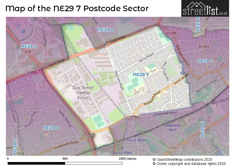
The NE29 7 Postcode shares a border with NE28 0 (WALLSEND), NE29 0 (NORTH SHIELDS), NE29 8 (NORTH SHIELDS), NE28 9 (WALLSEND) and NE29 6 (NORTH SHIELDS, Percy Main, Smiths Dock).
Map of the NE29 7 Postcode Sector
Explore the NE29 7 postcode sector by using our interactive map.
The sector is within the post town of NORTH SHIELDS.
NE29 7 is a postcode sector within the NE29 postcode district which is within the NE Newcastle upon Tyne postcode area.
The Royal Mail delivery office for the NE29 7 postal sector is the North Tyneside Delivery Office.
The area of the NE29 7 postcode sector is 1.03 square miles which is 2.67 square kilometres or 660.52 square acres.
The NE29 7 postcode sector is crossed by the A19 Major A road.
Your support helps keep this site running!
If you enjoy using this website, consider buying me a coffee to help cover hosting costs.

| N | E | 2 | 9 | - | 7 | X | X |
| N | E | 2 | 9 | Space | 7 | Letter | Letter |
Official List of Streets
NORTH SHIELDS (104 Streets)
Tyne Tunnel Trading Estate (11 Streets)
Chirton (2 Streets)
Orion Business Park (4 Streets)
Unofficial Streets or Alternative Spellings
NORTH SHIELDS
BILLY MILL AVENUE CHIRTON LANE NORHAM ROAD NORTH WATERVILLE ROAD BARMOUTH ROAD COAST ROAD CYCLEWAY EXMOUTH ROAD FALMOUTH ROAD HEADLEY COURT HOWDON INTERCHANGE LOSSIEMOUTH ROAD MITTFORD GROVE PERCY ROAD REGENT TERRACE SIDMOUTH ROAD SILVERLINK INTERCHANGE ROUNDABOUTNEWCASTLE UPON TYNE,
COAST ROADWeather Forecast for NE29 7
Weather Forecast for Chirton
| Time Period | Icon | Description | Temperature | Rain Probability | Wind |
|---|---|---|---|---|---|
| 00:00 to 03:00 | Cloudy | 6.0°C (feels like 3.0°C) | 4.00% | SSW 7 mph | |
| 03:00 to 06:00 | Cloudy | 5.0°C (feels like 3.0°C) | 4.00% | SSW 7 mph | |
| 06:00 to 09:00 | Cloudy | 5.0°C (feels like 2.0°C) | 4.00% | S 9 mph | |
| 09:00 to 12:00 | Cloudy | 5.0°C (feels like 2.0°C) | 4.00% | SSW 11 mph | |
| 12:00 to 15:00 | Cloudy | 8.0°C (feels like 5.0°C) | 5.00% | SSW 11 mph | |
| 15:00 to 18:00 | Cloudy | 9.0°C (feels like 6.0°C) | 5.00% | SSW 11 mph | |
| 18:00 to 21:00 | Cloudy | 8.0°C (feels like 4.0°C) | 5.00% | S 11 mph | |
| 21:00 to 00:00 | Cloudy | 7.0°C (feels like 4.0°C) | 5.00% | S 13 mph |
| Time Period | Icon | Description | Temperature | Rain Probability | Wind |
|---|---|---|---|---|---|
| 00:00 to 03:00 | Cloudy | 7.0°C (feels like 4.0°C) | 5.00% | S 13 mph | |
| 03:00 to 06:00 | Cloudy | 8.0°C (feels like 4.0°C) | 4.00% | SSW 13 mph | |
| 06:00 to 09:00 | Cloudy | 8.0°C (feels like 5.0°C) | 5.00% | SSW 16 mph | |
| 09:00 to 12:00 | Cloudy | 8.0°C (feels like 5.0°C) | 6.00% | SSW 16 mph | |
| 12:00 to 15:00 | Cloudy | 10.0°C (feels like 7.0°C) | 6.00% | SSW 16 mph | |
| 15:00 to 18:00 | Cloudy | 10.0°C (feels like 7.0°C) | 7.00% | SW 13 mph | |
| 18:00 to 21:00 | Clear night | 8.0°C (feels like 5.0°C) | 3.00% | SW 13 mph | |
| 21:00 to 00:00 | Clear night | 7.0°C (feels like 3.0°C) | 3.00% | WSW 13 mph |
| Time Period | Icon | Description | Temperature | Rain Probability | Wind |
|---|---|---|---|---|---|
| 00:00 to 03:00 | Clear night | 6.0°C (feels like 2.0°C) | 3.00% | WSW 16 mph | |
| 03:00 to 06:00 | Clear night | 5.0°C (feels like 1.0°C) | 1.00% | WSW 16 mph | |
| 06:00 to 09:00 | Clear night | 4.0°C (feels like 0.0°C) | 0.00% | W 13 mph | |
| 09:00 to 12:00 | Sunny day | 4.0°C (feels like 0.0°C) | 0.00% | WSW 13 mph | |
| 12:00 to 15:00 | Sunny day | 7.0°C (feels like 3.0°C) | 1.00% | W 13 mph | |
| 15:00 to 18:00 | Sunny day | 7.0°C (feels like 4.0°C) | 0.00% | W 11 mph | |
| 18:00 to 21:00 | Clear night | 5.0°C (feels like 2.0°C) | 0.00% | WSW 9 mph | |
| 21:00 to 00:00 | Clear night | 4.0°C (feels like 1.0°C) | 0.00% | WSW 9 mph |
| Time Period | Icon | Description | Temperature | Rain Probability | Wind |
|---|---|---|---|---|---|
| 00:00 to 03:00 | Clear night | 3.0°C (feels like 0.0°C) | 0.00% | WSW 7 mph | |
| 03:00 to 06:00 | Clear night | 3.0°C (feels like 0.0°C) | 1.00% | WSW 7 mph | |
| 06:00 to 09:00 | Clear night | 2.0°C (feels like -1.0°C) | 1.00% | WSW 7 mph | |
| 09:00 to 12:00 | Sunny day | 3.0°C (feels like 0.0°C) | 1.00% | SW 4 mph | |
| 12:00 to 15:00 | Sunny day | 6.0°C (feels like 5.0°C) | 1.00% | SSW 4 mph | |
| 15:00 to 18:00 | Sunny day | 7.0°C (feels like 5.0°C) | 1.00% | S 7 mph | |
| 18:00 to 21:00 | Clear night | 4.0°C (feels like 2.0°C) | 1.00% | S 7 mph | |
| 21:00 to 00:00 | Clear night | 3.0°C (feels like 1.0°C) | 1.00% | S 7 mph |
Schools and Places of Education Within the NE29 7 Postcode Sector
Collingwood Primary School
Community school
Oswin Terrace, North Shields, Tyne and Wear, NE29 7JQ
Head: Mrs Sharon Grant
Ofsted Rating: Good
Inspection: 2023-05-05 (640 days ago)
Website: Visit Collingwood Primary School Website
Phone: 01916053378
Number of Pupils: 335
Norham High School
Foundation school
Alnwick Avenue, North Shields, Tyne and Wear, NE29 7BU
Head: Mr Terence Richard Conway
Ofsted Rating: Good
Inspection: 2022-03-23 (1048 days ago)
Website: Visit Norham High School Website
Phone: 01918143890
Number of Pupils: 364
House Prices in the NE29 7 Postcode Sector
| Type of Property | 2018 Average | 2018 Sales | 2017 Average | 2017 Sales | 2016 Average | 2016 Sales | 2015 Average | 2015 Sales |
|---|---|---|---|---|---|---|---|---|
| Detached | £0 | 0 | £0 | 0 | £145,000 | 1 | £130,000 | 1 |
| Semi-Detached | £131,176 | 34 | £121,669 | 36 | £120,748 | 32 | £111,746 | 28 |
| Terraced | £108,867 | 23 | £102,786 | 25 | £104,100 | 26 | £93,761 | 19 |
| Flats | £68,059 | 34 | £64,660 | 34 | £69,038 | 20 | £56,337 | 23 |
Important Postcodes NE29 7 in the Postcode Sector
NE29 7BT is the postcode for St Joseph's RC VA Primary School, Wallsend Road
NE29 7BU is the postcode for Norham High School, Alnwick Avenue, and Norham Community Technology College, Alnwick Avenue
NE29 7JQ is the postcode for Collingwood Primary School, Oswin Terrace
NE29 7ST is the postcode for Hedley Court, 12 Hedley Court
| The NE29 7 Sector is within these Local Authorities |
|
|---|---|
| The NE29 7 Sector is within these Counties |
|
| The NE29 7 Sector is within these Water Company Areas |
|