A wide range of spatial data has been analysed to present this overview of the N7 0 Postcode sector. If you would like anything added, please contact us.
The N7 0 London (Holloway) Postcode Sector
The N7 0 postcode sector is within the county of Greater London.
Did you know? According to the 2021 Census, the N7 0 postcode sector is home to a bustling 11,882 residents!
Given that each sector allows for 400 unique postcode combinations. Letters C, I, K, M, O and V are not allowed in the last two letters of a postcode. With 184 postcodes already in use, this leaves 216 units available.
The largest settlements in the N7 0 postal code are ISLINGTON and LONDON .
The N7 0 Postcode shares a border with N7 6 (ISLINGTON ), N7 9 (ISLINGTON , LONDON ), N19 5 (ISLINGTON , LONDON ), NW1 9 (LONDON ), N19 4 (ISLINGTON ) and NW5 2 (LONDON ).
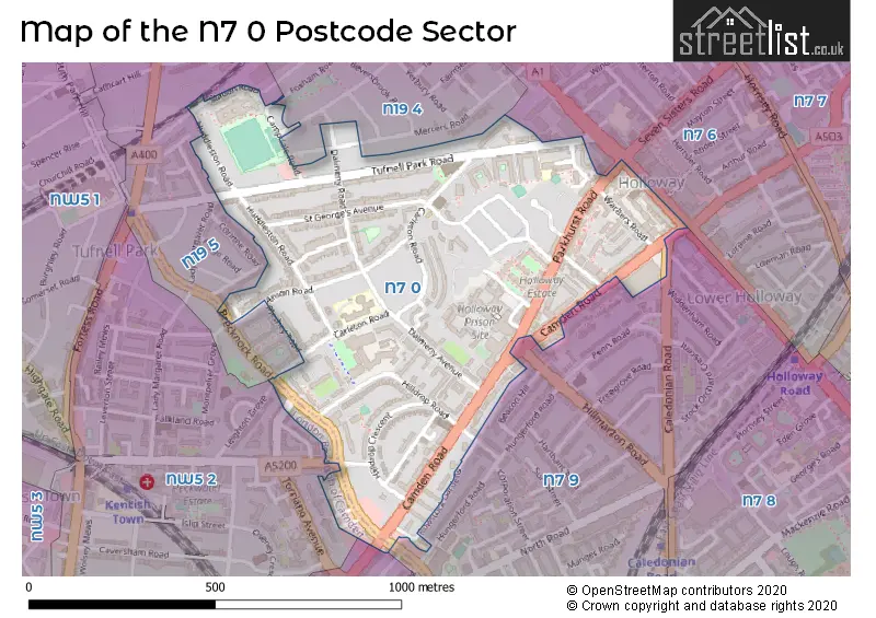
Map of the N7 0 Postcode Sector
Explore the N7 0 postcode sector by using our interactive map.
The sector is within the post town of LONDON.
N7 0 is a postcode sector within the N7 postcode district which is within the N North London postcode area.
The Royal Mail delivery office for the N7 0 postal sector is the Holloway Sdelivery Office.
The area of the N7 0 postcode sector is 0.32 square miles which is 0.83 square kilometres or 204.79 square acres.
Your support helps keep this site running!
If you enjoy using this website, consider buying me a coffee to help cover hosting costs.

| N | 7 | - | 0 | X | X |
| N | 7 | Space | 0 | Letter | Letter |
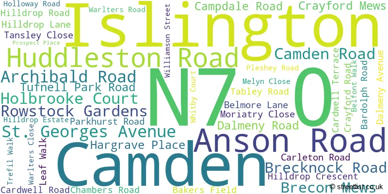
Official List of Streets
Islington (40 Streets)
Camden (3 Streets)
Unofficial Streets or Alternative Spellings
Islington
BIDDESTONE ROAD CALEDONIAN ROAD FOXHAM ROAD HILLMARTON ROAD HUNGERFORD ROAD MERCERS MEWS MERCERS ROAD MIDDLETON GROVE STATION ROAD TYTHERTON ROADCamden
CAMDEN ROAD LEIGHTON GROVE LEIGHTON ROAD TORRIANO AVENUE YORK WAY CARDWELL MEWS LONDON POWER TUNNELS ST JOHNS WOOD - HACKNEY MARGERY FRY COURT MOELWYN HUGHES COURT PENDERYN WAY TRECASTLE WAYWeather Forecast for N7 0
Weather Forecast for Arsenal F.C.
| Time Period | Icon | Description | Temperature | Rain Probability | Wind |
|---|---|---|---|---|---|
| 12:00 to 15:00 | Cloudy | 6.0°C (feels like 4.0°C) | 6.00% | SE 4 mph | |
| 15:00 to 18:00 | Cloudy | 9.0°C (feels like 7.0°C) | 6.00% | SSE 7 mph | |
| 18:00 to 21:00 | Cloudy | 8.0°C (feels like 7.0°C) | 9.00% | SSE 4 mph | |
| 21:00 to 00:00 | Overcast | 8.0°C (feels like 6.0°C) | 10.00% | S 7 mph |
| Time Period | Icon | Description | Temperature | Rain Probability | Wind |
|---|---|---|---|---|---|
| 00:00 to 03:00 | Heavy rain | 8.0°C (feels like 6.0°C) | 74.00% | S 7 mph | |
| 03:00 to 06:00 | Heavy rain | 9.0°C (feels like 7.0°C) | 74.00% | S 9 mph | |
| 06:00 to 09:00 | Overcast | 9.0°C (feels like 7.0°C) | 44.00% | SSW 11 mph | |
| 09:00 to 12:00 | Overcast | 11.0°C (feels like 8.0°C) | 47.00% | SSW 11 mph | |
| 12:00 to 15:00 | Overcast | 11.0°C (feels like 9.0°C) | 50.00% | SSW 13 mph | |
| 15:00 to 18:00 | Overcast | 12.0°C (feels like 10.0°C) | 16.00% | SSW 13 mph | |
| 18:00 to 21:00 | Overcast | 12.0°C (feels like 10.0°C) | 14.00% | SSW 11 mph | |
| 21:00 to 00:00 | Overcast | 12.0°C (feels like 10.0°C) | 12.00% | SSW 9 mph |
| Time Period | Icon | Description | Temperature | Rain Probability | Wind |
|---|---|---|---|---|---|
| 00:00 to 03:00 | Overcast | 12.0°C (feels like 10.0°C) | 14.00% | SSW 9 mph | |
| 03:00 to 06:00 | Overcast | 11.0°C (feels like 9.0°C) | 15.00% | S 11 mph | |
| 06:00 to 09:00 | Overcast | 12.0°C (feels like 9.0°C) | 22.00% | S 11 mph | |
| 09:00 to 12:00 | Cloudy | 12.0°C (feels like 10.0°C) | 11.00% | S 13 mph | |
| 12:00 to 15:00 | Cloudy | 14.0°C (feels like 11.0°C) | 6.00% | S 13 mph | |
| 15:00 to 18:00 | Cloudy | 14.0°C (feels like 12.0°C) | 8.00% | S 13 mph | |
| 18:00 to 21:00 | Cloudy | 13.0°C (feels like 11.0°C) | 13.00% | S 11 mph | |
| 21:00 to 00:00 | Cloudy | 12.0°C (feels like 10.0°C) | 21.00% | SSW 11 mph |
| Time Period | Icon | Description | Temperature | Rain Probability | Wind |
|---|---|---|---|---|---|
| 00:00 to 03:00 | Light rain | 11.0°C (feels like 9.0°C) | 51.00% | SSW 9 mph | |
| 03:00 to 06:00 | Overcast | 10.0°C (feels like 9.0°C) | 21.00% | SSW 7 mph | |
| 06:00 to 09:00 | Cloudy | 10.0°C (feels like 9.0°C) | 14.00% | SSW 4 mph | |
| 09:00 to 12:00 | Cloudy | 10.0°C (feels like 9.0°C) | 15.00% | SW 4 mph | |
| 12:00 to 15:00 | Cloudy | 11.0°C (feels like 10.0°C) | 14.00% | WSW 7 mph | |
| 15:00 to 18:00 | Cloudy | 12.0°C (feels like 11.0°C) | 7.00% | WSW 7 mph | |
| 18:00 to 21:00 | Clear night | 11.0°C (feels like 10.0°C) | 2.00% | SW 7 mph | |
| 21:00 to 00:00 | Clear night | 9.0°C (feels like 8.0°C) | 3.00% | SW 7 mph |
| Time Period | Icon | Description | Temperature | Rain Probability | Wind |
|---|---|---|---|---|---|
| 00:00 to 03:00 | Partly cloudy (night) | 8.0°C (feels like 6.0°C) | 4.00% | SSW 7 mph | |
| 03:00 to 06:00 | Partly cloudy (night) | 8.0°C (feels like 5.0°C) | 5.00% | SSW 9 mph | |
| 06:00 to 09:00 | Cloudy | 8.0°C (feels like 5.0°C) | 9.00% | SSW 11 mph | |
| 09:00 to 12:00 | Cloudy | 9.0°C (feels like 6.0°C) | 13.00% | SSW 13 mph | |
| 12:00 to 15:00 | Cloudy | 11.0°C (feels like 8.0°C) | 18.00% | SSW 18 mph | |
| 15:00 to 18:00 | Cloudy | 11.0°C (feels like 8.0°C) | 23.00% | SSW 18 mph | |
| 18:00 to 21:00 | Cloudy | 11.0°C (feels like 8.0°C) | 24.00% | SSW 18 mph | |
| 21:00 to 00:00 | Cloudy | 11.0°C (feels like 8.0°C) | 24.00% | SSW 16 mph |
Schools and Places of Education Within the N7 0 Postcode Sector
Beacon High
Community school
Hilldrop Road, London, , N7 0JG
Head: Mr Alan Streeter
Ofsted Rating: Good
Inspection: 2022-11-17 (825 days ago)
Website: Visit Beacon High Website
Phone: 02076075885
Number of Pupils: 381
Tufnell Park Primary School
Community school
31 Carleton Road, London, , N7 0HJ
Head: Mr Martin Scarborough
Ofsted Rating: Good
Inspection: 2022-10-06 (867 days ago)
Website: Visit Tufnell Park Primary School Website
Phone: 02076074852
Number of Pupils: 435
House Prices in the N7 0 Postcode Sector
| Type of Property | 2018 Average | 2018 Sales | 2017 Average | 2017 Sales | 2016 Average | 2016 Sales | 2015 Average | 2015 Sales |
|---|---|---|---|---|---|---|---|---|
| Detached | £0 | 0 | £2,035,920 | 2 | £2,335,000 | 1 | £2,550,000 | 2 |
| Semi-Detached | £0 | 0 | £1,987,500 | 1 | £1,282,500 | 2 | £0 | 0 |
| Terraced | £1,463,427 | 11 | £1,198,333 | 12 | £1,440,033 | 15 | £1,036,414 | 18 |
| Flats | £498,784 | 83 | £464,974 | 76 | £515,764 | 93 | £492,087 | 97 |
Important Postcodes N7 0 in the Postcode Sector
N7 0BF is the postcode for Willow Childrens Centre, 1a Holbrooke Court, Islington
N7 0EQ is the postcode for The Bridge School, 28 Carleton Road
N7 0HJ is the postcode for Tufnell Park Primary School, 31 Carleton Road, Tufnell Park Primary School, 31 Carleton Road, Islington, and Tufnell Park Primary School, Dalmeny Road
N7 0JG is the postcode for Beacon High, Hilldrop Road, and BEACON HIGH, HILLDROP ROAD, ISLINGTON
N7 0NU is the postcode for H M Prison, Holloway, Parkhurst Road, and VISITS HALL HMP HOLLOWAY, H M Prison, Holloway, Parkhurst Road
N7 0RN is the postcode for The City & Islington College, The Marlborough Building, 383 Holloway Road, and CITY AND ISLINGTON COLLEGE, 383 383 HOLLOWAY ROAD, ISLINGTON
N7 0SL is the postcode for Partnership Primary Care Centre, 331 Camden Road
N7 0SP is the postcode for City & Islington College, 444 Camden Road, and CITY AND ISLINGTON COLLEGE, 444 CAMDEN ROAD, ISLINGTON
| The N7 0 Sector is within these Local Authorities |
|
|---|---|
| The N7 0 Sector is within these Counties |
|
| The N7 0 Sector is within these Water Company Areas |
|