A wide range of spatial data has been analysed to present this overview of the N4 2 Postcode sector. If you would like anything added, please contact us.
The N4 2 postcode sector is within the county of Greater London.
Did you know? According to the 2021 Census, the N4 2 postcode sector is home to a bustling 18,730 residents!
Given that each sector allows for 400 unique postcode combinations. Letters C, I, K, M, O and V are not allowed in the last two letters of a postcode. With 287 postcodes already in use, this leaves 113 units available.
The largest settlements in the N4 2 postal code are HACKNEY and ISLINGTON .
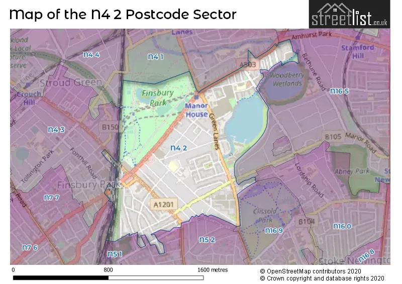
The N4 2 Postcode shares a border with N4 3 (ISLINGTON , HORNSEY ), N4 1 (TOTTENHAM , HORNSEY , HACKNEY ), N5 1 (ISLINGTON ), N5 2 (ISLINGTON , HACKNEY ), N16 0 (HACKNEY ), N16 9 (HACKNEY , ISLINGTON ), N16 5 (HACKNEY ), N4 4 (HORNSEY , ISLINGTON ) and N7 7 (ISLINGTON ).
Map of the N4 2 Postcode Sector
Explore the N4 2 postcode sector by using our interactive map.
The sector is within the post town of LONDON.
N4 2 is a postcode sector within the N4 postcode district which is within the N North London postcode area.
The Royal Mail delivery office for the N4 2 postal sector is the Finsbury Park Sdelivery Office.
The area of the N4 2 postcode sector is 0.58 square miles which is 1.50 square kilometres or 371.71 square acres.
Waterways within the N4 2 postcode sector include the New River.
Your support helps keep this site running!
If you enjoy using this website, consider buying me a coffee to help cover hosting costs.

| N | 4 | - | 2 | X | X |
| N | 4 | Space | 2 | Letter | Letter |
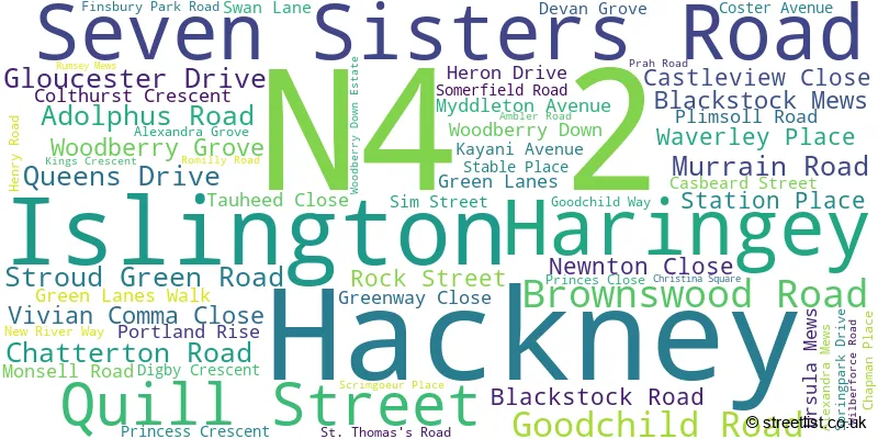
Official List of Streets
Hackney (44 Streets)
Islington (17 Streets)
Haringey (2 Streets)
Unofficial Streets or Alternative Spellings
Hackney
LORDSHIP PARK LORDSHIP ROAD MOUNTGROVE ROAD BRAND CLOSE CHATTERTON MEWS COBBLE MEWS DATCHWORTH COURT FINSBURY GATE JOSEPH CLOSE NEW RIVER PATH / CAPITAL RING PANKHURST MEWS QUEEN ELIZABETHS CLOSE RIVERSIDE GARDENS SAINT THOMASS ROADIslington
AVENELL ROAD ELWOOD STREET FONTHILL ROAD GILLESPIE ROAD ISLEDON ROAD MORRIS PLACE WELLS TERRACEWeather Forecast for N4 2
Weather Forecast for Arsenal F.C.
| Time Period | Icon | Description | Temperature | Rain Probability | Wind |
|---|---|---|---|---|---|
| 03:00 to 06:00 | Clear night | 3.0°C (feels like 1.0°C) | 0.00% | SSE 4 mph | |
| 06:00 to 09:00 | Clear night | 2.0°C (feels like 0.0°C) | 1.00% | SE 4 mph | |
| 09:00 to 12:00 | Sunny day | 2.0°C (feels like 1.0°C) | 0.00% | SE 4 mph | |
| 12:00 to 15:00 | Sunny day | 5.0°C (feels like 4.0°C) | 0.00% | SSE 4 mph | |
| 15:00 to 18:00 | Sunny day | 7.0°C (feels like 5.0°C) | 0.00% | S 4 mph | |
| 18:00 to 21:00 | Clear night | 5.0°C (feels like 3.0°C) | 0.00% | SSW 4 mph | |
| 21:00 to 00:00 | Clear night | 3.0°C (feels like 2.0°C) | 1.00% | SSW 4 mph |
| Time Period | Icon | Description | Temperature | Rain Probability | Wind |
|---|---|---|---|---|---|
| 00:00 to 03:00 | Clear night | 2.0°C (feels like 0.0°C) | 2.00% | SSW 4 mph | |
| 03:00 to 06:00 | Cloudy | 1.0°C (feels like -1.0°C) | 5.00% | SSW 4 mph | |
| 06:00 to 09:00 | Cloudy | 1.0°C (feels like -1.0°C) | 6.00% | SW 4 mph | |
| 09:00 to 12:00 | Overcast | 3.0°C (feels like 1.0°C) | 9.00% | SSW 4 mph | |
| 12:00 to 15:00 | Cloudy | 6.0°C (feels like 4.0°C) | 6.00% | SSW 4 mph | |
| 15:00 to 18:00 | Partly cloudy (day) | 8.0°C (feels like 6.0°C) | 2.00% | SSW 7 mph | |
| 18:00 to 21:00 | Partly cloudy (night) | 6.0°C (feels like 4.0°C) | 2.00% | SSW 7 mph | |
| 21:00 to 00:00 | Partly cloudy (night) | 5.0°C (feels like 2.0°C) | 2.00% | SSW 7 mph |
| Time Period | Icon | Description | Temperature | Rain Probability | Wind |
|---|---|---|---|---|---|
| 00:00 to 03:00 | Cloudy | 4.0°C (feels like 2.0°C) | 5.00% | SSW 7 mph | |
| 03:00 to 06:00 | Clear night | 5.0°C (feels like 2.0°C) | 3.00% | SSW 7 mph | |
| 06:00 to 09:00 | Partly cloudy (night) | 5.0°C (feels like 2.0°C) | 3.00% | SSW 7 mph | |
| 09:00 to 12:00 | Partly cloudy (day) | 6.0°C (feels like 3.0°C) | 2.00% | SSW 9 mph | |
| 12:00 to 15:00 | Overcast | 9.0°C (feels like 6.0°C) | 8.00% | SSW 11 mph | |
| 15:00 to 18:00 | Cloudy | 10.0°C (feels like 7.0°C) | 10.00% | SSW 11 mph | |
| 18:00 to 21:00 | Overcast | 9.0°C (feels like 6.0°C) | 19.00% | SSW 9 mph | |
| 21:00 to 00:00 | Cloudy | 8.0°C (feels like 6.0°C) | 17.00% | SW 9 mph |
| Time Period | Icon | Description | Temperature | Rain Probability | Wind |
|---|---|---|---|---|---|
| 00:00 to 03:00 | Clear night | 7.0°C (feels like 5.0°C) | 8.00% | WSW 7 mph | |
| 03:00 to 06:00 | Clear night | 6.0°C (feels like 4.0°C) | 5.00% | W 4 mph | |
| 06:00 to 09:00 | Clear night | 4.0°C (feels like 2.0°C) | 2.00% | WNW 4 mph | |
| 09:00 to 12:00 | Partly cloudy (day) | 4.0°C (feels like 2.0°C) | 2.00% | WNW 4 mph | |
| 12:00 to 15:00 | Partly cloudy (day) | 7.0°C (feels like 6.0°C) | 1.00% | NW 4 mph | |
| 15:00 to 18:00 | Cloudy | 8.0°C (feels like 7.0°C) | 5.00% | N 4 mph | |
| 18:00 to 21:00 | Cloudy | 7.0°C (feels like 6.0°C) | 5.00% | N 4 mph | |
| 21:00 to 00:00 | Cloudy | 5.0°C (feels like 4.0°C) | 5.00% | N 4 mph |
Schools and Places of Education Within the N4 2 Postcode Sector
Ambler Primary School and Children's Centre
Community school
Blackstock Road, London, , N4 2DR
Head: Mrs Sandeep McNicholl
Ofsted Rating: Outstanding
Inspection: 2023-03-09 (696 days ago)
Website: Visit Ambler Primary School and Children's Centre Website
Phone: 02072264708
Number of Pupils: 505
Beis Chinuch Lebonos Girls School
Other independent school
Woodberry Down Centre, London, , N4 2SH
Head: Mrs Leah Klein
Ofsted Rating: Requires improvement
Inspection: 2022-12-01 (794 days ago)
Website: Visit Beis Chinuch Lebonos Girls School Website
Phone: 02088097737
Number of Pupils: 747
Parkwood Primary School
Community school
Queen's Drive, LONDON, , N4 2HQ
Head: Mr Paul Thomas
Ofsted Rating: Good
Inspection: 2019-06-13 (2061 days ago)
Website: Visit Parkwood Primary School Website
Phone: 02088025366
Number of Pupils: 210
House Prices in the N4 2 Postcode Sector
| Type of Property | 2018 Average | 2018 Sales | 2017 Average | 2017 Sales | 2016 Average | 2016 Sales | 2015 Average | 2015 Sales |
|---|---|---|---|---|---|---|---|---|
| Detached | £0 | 0 | £1,739,998 | 1 | £1,425,000 | 1 | £0 | 0 |
| Semi-Detached | £1,235,000 | 3 | £763,000 | 1 | £1,536,400 | 5 | £1,437,500 | 2 |
| Terraced | £1,149,934 | 21 | £1,127,215 | 20 | £1,103,625 | 24 | £998,320 | 25 |
| Flats | £568,934 | 375 | £469,989 | 458 | £560,602 | 316 | £458,779 | 340 |
Important Postcodes N4 2 in the Postcode Sector
N4 2AB is the postcode for Post Office, Finsbury Park Post Office, 290 Seven Sisters Road
N4 2DG is the postcode for CITY AND ISLINGTON COLLEGE LIFELONG LEARNING NURSERY, 28-42 BLACKSTOCK ROAD, ISLINGTON, and Islington & City Learning Centre, 24-42 Blackstock Road
N4 2DR is the postcode for Ambler Primary School, Blackstock Road, and Ambler Primary School, 80 Blackstock Road, Islington
N4 2ES is the postcode for Wolfson House, 311-315 Green Lanes, and East London NHS Foundation Trust, 311-315 Green Lanes
N4 2HA is the postcode for West Reservoir Centre, Green Lanes
N4 2HQ is the postcode for Parkwood Primary School, Queens Drive, and PARKWOOD PRIMARY SCHOOL, Queens Drive, Hackney
N4 2NU is the postcode for John Scott Health Centre, Green Lanes
| The N4 2 Sector is within these Local Authorities |
|
|---|---|
| The N4 2 Sector is within these Counties |
|
| The N4 2 Sector is within these Water Company Areas |
|