A wide range of spatial data has been analysed to present this overview of the N4 1 Postcode sector. If you would like anything added, please contact us.
The N4 1 London (Wood Green) Postcode Sector
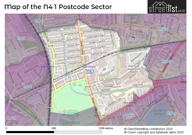
The N4 1 postcode sector is within the county of Greater London.
Did you know? According to the 2021 Census, the N4 1 postcode sector is home to a bustling 13,823 residents!
Given that each sector allows for 400 unique postcode combinations. Letters C, I, K, M, O and V are not allowed in the last two letters of a postcode. With 203 postcodes already in use, this leaves 197 units available.
The largest settlement in the N4 1 postal code is TOTTENHAM followed by HORNSEY , and HACKNEY .
The N4 1 Postcode shares a border with N8 0 (HORNSEY , WOOD GREEN , TOTTENHAM ), N8 9 (HORNSEY , ISLINGTON ), N15 5 (TOTTENHAM ), N4 2 (HACKNEY , ISLINGTON ), N15 3 (TOTTENHAM ), N15 6 (TOTTENHAM ), N16 5 (HACKNEY ) and N4 4 (HORNSEY , ISLINGTON ).
Map of the N4 1 Postcode Sector
Explore the N4 1 postcode sector by using our interactive map.
The sector is within the post town of LONDON.
N4 1 is a postcode sector within the N4 postcode district which is within the N North London postcode area.
The Royal Mail delivery office for the N4 1 postal sector is the Finsbury Park Sdelivery Office.
The area of the N4 1 postcode sector is 0.48 square miles which is 1.24 square kilometres or 306.08 square acres.
Waterways within the N4 1 postcode sector include the New River.
Your support helps keep this site running!
If you enjoy using this website, consider buying me a coffee to help cover hosting costs.


| N | 4 | - | 1 | X | X |
| N | 4 | Space | 1 | Letter | Letter |
Official List of Streets
Haringey (49 Streets)
Unofficial Streets or Alternative Spellings
Weather Forecast for N4 1
Weather Forecast for Harringay
| Time Period | Icon | Description | Temperature | Rain Probability | Wind |
|---|---|---|---|---|---|
| 06:00 to 09:00 | Light rain | 10.0°C (feels like 9.0°C) | 55.00% | SW 4 mph | |
| 09:00 to 12:00 | Cloudy | 10.0°C (feels like 9.0°C) | 9.00% | WSW 4 mph | |
| 12:00 to 15:00 | Thunder | 11.0°C (feels like 10.0°C) | 54.00% | WSW 7 mph | |
| 15:00 to 18:00 | Light rain shower (day) | 13.0°C (feels like 11.0°C) | 38.00% | WSW 7 mph | |
| 18:00 to 21:00 | Clear night | 11.0°C (feels like 10.0°C) | 5.00% | SW 7 mph | |
| 21:00 to 00:00 | Clear night | 9.0°C (feels like 8.0°C) | 0.00% | SW 7 mph |
| Time Period | Icon | Description | Temperature | Rain Probability | Wind |
|---|---|---|---|---|---|
| 00:00 to 03:00 | Clear night | 8.0°C (feels like 6.0°C) | 2.00% | SSW 7 mph | |
| 03:00 to 06:00 | Cloudy | 8.0°C (feels like 6.0°C) | 5.00% | SSW 9 mph | |
| 06:00 to 09:00 | Cloudy | 8.0°C (feels like 6.0°C) | 5.00% | SSW 9 mph | |
| 09:00 to 12:00 | Cloudy | 9.0°C (feels like 6.0°C) | 5.00% | SSW 13 mph | |
| 12:00 to 15:00 | Cloudy | 11.0°C (feels like 8.0°C) | 6.00% | SSW 16 mph | |
| 15:00 to 18:00 | Cloudy | 11.0°C (feels like 8.0°C) | 12.00% | SSW 16 mph | |
| 18:00 to 21:00 | Light rain | 11.0°C (feels like 7.0°C) | 52.00% | SSW 18 mph | |
| 21:00 to 00:00 | Heavy rain | 11.0°C (feels like 7.0°C) | 83.00% | SSW 18 mph |
| Time Period | Icon | Description | Temperature | Rain Probability | Wind |
|---|---|---|---|---|---|
| 00:00 to 03:00 | Heavy rain | 10.0°C (feels like 8.0°C) | 86.00% | SSW 16 mph | |
| 03:00 to 06:00 | Heavy rain | 10.0°C (feels like 8.0°C) | 79.00% | SSW 13 mph | |
| 06:00 to 09:00 | Light rain | 10.0°C (feels like 8.0°C) | 51.00% | SW 11 mph | |
| 09:00 to 12:00 | Cloudy | 10.0°C (feels like 8.0°C) | 18.00% | SW 9 mph | |
| 12:00 to 15:00 | Cloudy | 12.0°C (feels like 10.0°C) | 21.00% | SW 11 mph | |
| 15:00 to 18:00 | Partly cloudy (day) | 12.0°C (feels like 10.0°C) | 20.00% | SW 9 mph | |
| 18:00 to 21:00 | Partly cloudy (night) | 10.0°C (feels like 9.0°C) | 12.00% | SW 7 mph | |
| 21:00 to 00:00 | Clear night | 9.0°C (feels like 7.0°C) | 10.00% | SW 7 mph |
| Time Period | Icon | Description | Temperature | Rain Probability | Wind |
|---|---|---|---|---|---|
| 00:00 to 03:00 | Clear night | 8.0°C (feels like 6.0°C) | 10.00% | SW 7 mph | |
| 03:00 to 06:00 | Clear night | 7.0°C (feels like 5.0°C) | 11.00% | WSW 7 mph | |
| 06:00 to 09:00 | Partly cloudy (night) | 6.0°C (feels like 4.0°C) | 11.00% | WSW 7 mph | |
| 09:00 to 12:00 | Partly cloudy (day) | 7.0°C (feels like 5.0°C) | 11.00% | WSW 7 mph | |
| 12:00 to 15:00 | Partly cloudy (day) | 9.0°C (feels like 7.0°C) | 11.00% | W 9 mph | |
| 15:00 to 18:00 | Cloudy | 10.0°C (feels like 8.0°C) | 15.00% | W 9 mph | |
| 18:00 to 21:00 | Clear night | 9.0°C (feels like 7.0°C) | 12.00% | NW 7 mph | |
| 21:00 to 00:00 | Clear night | 7.0°C (feels like 5.0°C) | 8.00% | WNW 7 mph |
Schools and Places of Education Within the N4 1 Postcode Sector
Skinners' Academy
Academy sponsor led
Woodberry Grove, London, , N4 1SY
Head: Principal Shereka James
Ofsted Rating: Good
Inspection: 2022-05-12 (1017 days ago)
Website: Visit Skinners' Academy Website
Phone: 02088007411
Number of Pupils: 1064
South Harringay Infant School
Community school
Pemberton Road, London, , N4 1BA
Head: Mr I Scotchbrook
Ofsted Rating: Good
Inspection: 2023-05-25 (639 days ago)
Website: Visit South Harringay Infant School Website
Phone: 02083402757
Number of Pupils: 215
South Harringay Junior School
Community school
Pemberton Rd, London, , N4 1BA
Head: Mr Ian Scotchbrook
Ofsted Rating: Outstanding
Inspection: 2023-05-25 (639 days ago)
Website: Visit South Harringay Junior School Website
Phone: 02083402757
Number of Pupils: 210
Woodberry Down Community Primary School
Community school
Woodberry Grove, London, , N4 1SY
Head: Ms Nicole Reid (Executive Headteacher)
Ofsted Rating: Good
Inspection: 2023-12-06 (444 days ago)
Website: Visit Woodberry Down Community Primary School Website
Phone: 02088005758
Number of Pupils: 667
House Prices in the N4 1 Postcode Sector
| Type of Property | 2018 Average | 2018 Sales | 2017 Average | 2017 Sales | 2016 Average | 2016 Sales | 2015 Average | 2015 Sales |
|---|---|---|---|---|---|---|---|---|
| Detached | £670,000 | 1 | £0 | 0 | £0 | 0 | £0 | 0 |
| Semi-Detached | £949,500 | 5 | £720,000 | 2 | £885,750 | 2 | £984,167 | 3 |
| Terraced | £823,696 | 41 | £786,314 | 45 | £687,380 | 42 | £675,065 | 43 |
| Flats | £393,340 | 49 | £435,551 | 59 | £389,624 | 71 | £361,715 | 82 |
Important Postcodes N4 1 in the Postcode Sector
N4 1AE is the postcode for Barnet, Enfield and Haringey Mental Health NHS Trust, Burgoyne Road Clinic, 58 Burgoyne Road
N4 1BA is the postcode for South Harringay Infants School, Pemberton Road
N4 1BD is the postcode for South Harringay School, Mattison Road, INFANT & NURSERY, South Harringay School, Mattison Road, and POOL BUILDING, South Harringay School, Mattison Road
N4 1SY is the postcode for Woodberry Down Community Primary School, Woodberry Grove, and The Skinners Academy, Woodberry Grove
N4 1UU is the postcode for Royal Mail, Finsbury Park & South Tottenham Do Unit, 3 Green Lanes, Arena Industrial Estate
| The N4 1 Sector is within these Local Authorities |
|
|---|---|
| The N4 1 Sector is within these Counties |
|
| The N4 1 Sector is within these Water Company Areas |
|