A wide range of spatial data has been analysed to present this overview of the N20 8 Postcode sector. If you would like anything added, please contact us.
The N20 8 postcode sector is within the county of Greater London.
Did you know? According to the 2021 Census, the N20 8 postcode sector is home to a bustling 4,116 residents!
Given that each sector allows for 400 unique postcode combinations. Letters C, I, K, M, O and V are not allowed in the last two letters of a postcode. With 128 postcodes already in use, this leaves 272 units available.
The largest settlements in the N20 8 postal code are WHETSTONE and TOTTERIDGE .
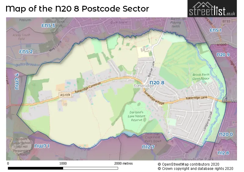
The N20 8 Postcode shares a border with N12 7 (NORTH FINCHLEY , WOODSIDE LANE TO WESTBURY ROAD , SOUTHOVER TO ARLINGTON ), N20 0 (WHETSTONE , FRIERN BARNET , OAKLEIGH PARK ), NW7 1 (MILL HILL , CHURCH END ), NW7 4 (MILL HILL , BARNET GATE , MARSH LANE TO TOTTERIDGE COMMON ), EN5 2 (BARNET , UNDERHILL , CHIPPING BARNET ), N20 9 (WHETSTONE ) and EN5 1 (NEW BARNET , BARNET , UNDERHILL ).
Map of the N20 8 Postcode Sector
Explore the N20 8 postcode sector by using our interactive map.
The sector is within the post town of LONDON.
N20 8 is a postcode sector within the N20 postcode district which is within the N North London postcode area.
The Royal Mail delivery office for the N20 8 postal sector is the Whetstone Sdelivery Office.
The area of the N20 8 postcode sector is 2.39 square miles which is 6.20 square kilometres or 1,531.55 square acres.
Waterways within the N20 8 postcode sector include the Folly Brook, Dollis Brook.
Your support helps keep this site running!
If you enjoy using this website, consider buying me a coffee to help cover hosting costs.

| N | 2 | 0 | - | 8 | X | X |
| N | 2 | 0 | Space | 8 | Letter | Letter |
Official List of Streets
Barnet (40 Streets)
Unofficial Streets or Alternative Spellings
Weather Forecast for N20 8
Weather Forecast for Barnet
| Time Period | Icon | Description | Temperature | Rain Probability | Wind |
|---|---|---|---|---|---|
| 21:00 to 00:00 | Clear night | 2.0°C (feels like -1.0°C) | 0.00% | S 4 mph |
| Time Period | Icon | Description | Temperature | Rain Probability | Wind |
|---|---|---|---|---|---|
| 00:00 to 03:00 | Partly cloudy (night) | 1.0°C (feels like -2.0°C) | 1.00% | SSW 4 mph | |
| 03:00 to 06:00 | Cloudy | 1.0°C (feels like -2.0°C) | 7.00% | SSW 7 mph | |
| 06:00 to 09:00 | Overcast | 2.0°C (feels like -1.0°C) | 8.00% | SSW 7 mph | |
| 09:00 to 12:00 | Overcast | 3.0°C (feels like 0.0°C) | 10.00% | SSW 7 mph | |
| 12:00 to 15:00 | Overcast | 6.0°C (feels like 3.0°C) | 10.00% | SSW 9 mph | |
| 15:00 to 18:00 | Overcast | 7.0°C (feels like 5.0°C) | 8.00% | SSW 9 mph | |
| 18:00 to 21:00 | Cloudy | 6.0°C (feels like 3.0°C) | 6.00% | S 9 mph | |
| 21:00 to 00:00 | Overcast | 6.0°C (feels like 2.0°C) | 8.00% | SSW 11 mph |
| Time Period | Icon | Description | Temperature | Rain Probability | Wind |
|---|---|---|---|---|---|
| 00:00 to 03:00 | Cloudy | 5.0°C (feels like 2.0°C) | 6.00% | SSW 11 mph | |
| 03:00 to 06:00 | Cloudy | 5.0°C (feels like 1.0°C) | 5.00% | SSW 11 mph | |
| 06:00 to 09:00 | Overcast | 6.0°C (feels like 2.0°C) | 8.00% | SSW 13 mph | |
| 09:00 to 12:00 | Overcast | 6.0°C (feels like 2.0°C) | 8.00% | SSW 13 mph | |
| 12:00 to 15:00 | Cloudy | 8.0°C (feels like 5.0°C) | 4.00% | SSW 16 mph | |
| 15:00 to 18:00 | Overcast | 9.0°C (feels like 6.0°C) | 11.00% | SSW 16 mph | |
| 18:00 to 21:00 | Light rain | 8.0°C (feels like 5.0°C) | 55.00% | SSW 13 mph | |
| 21:00 to 00:00 | Light rain shower (night) | 8.0°C (feels like 5.0°C) | 41.00% | WSW 11 mph |
| Time Period | Icon | Description | Temperature | Rain Probability | Wind |
|---|---|---|---|---|---|
| 00:00 to 03:00 | Clear night | 6.0°C (feels like 2.0°C) | 3.00% | WSW 11 mph | |
| 03:00 to 06:00 | Clear night | 5.0°C (feels like 1.0°C) | 0.00% | W 11 mph | |
| 06:00 to 09:00 | Clear night | 3.0°C (feels like 0.0°C) | 1.00% | W 9 mph | |
| 09:00 to 12:00 | Partly cloudy (day) | 4.0°C (feels like 0.0°C) | 1.00% | W 9 mph | |
| 12:00 to 15:00 | Cloudy | 7.0°C (feels like 4.0°C) | 4.00% | WNW 7 mph | |
| 15:00 to 18:00 | Cloudy | 7.0°C (feels like 5.0°C) | 4.00% | NW 7 mph | |
| 18:00 to 21:00 | Partly cloudy (night) | 4.0°C (feels like 3.0°C) | 1.00% | NW 4 mph | |
| 21:00 to 00:00 | Partly cloudy (night) | 3.0°C (feels like 1.0°C) | 1.00% | NNW 4 mph |
| Time Period | Icon | Description | Temperature | Rain Probability | Wind |
|---|---|---|---|---|---|
| 00:00 to 03:00 | Clear night | 2.0°C (feels like -1.0°C) | 1.00% | N 7 mph | |
| 03:00 to 06:00 | Clear night | 1.0°C (feels like -2.0°C) | 1.00% | N 7 mph | |
| 06:00 to 09:00 | Clear night | 0.0°C (feels like -3.0°C) | 1.00% | NNE 7 mph | |
| 09:00 to 12:00 | Sunny day | 1.0°C (feels like -2.0°C) | 1.00% | NE 7 mph | |
| 12:00 to 15:00 | Sunny day | 6.0°C (feels like 3.0°C) | 1.00% | NE 9 mph | |
| 15:00 to 18:00 | Sunny day | 7.0°C (feels like 4.0°C) | 1.00% | ENE 9 mph | |
| 18:00 to 21:00 | Clear night | 4.0°C (feels like 1.0°C) | 1.00% | NE 9 mph | |
| 21:00 to 00:00 | Clear night | 3.0°C (feels like -1.0°C) | 2.00% | NE 9 mph |
Schools and Places of Education Within the N20 8 Postcode Sector
St Andrew's CofE Voluntary Aided Primary School, Totteridge
Voluntary aided school
The Green, London, , N20 8NX
Head: Ms Jo Devine.
Ofsted Rating: Good
Inspection: 2022-03-09 (1061 days ago)
Website: Visit St Andrew's CofE Voluntary Aided Primary School, Totteridge Website
Phone: 02084456157
Number of Pupils: 204
The Totteridge Academy
Academy sponsor led
Barnet Lane, London, , N20 8AZ
Head: Mr Chris Fairbairn
Ofsted Rating: Good
Inspection: 2019-03-07 (2159 days ago)
Website: Visit The Totteridge Academy Website
Phone: 02084459205
Number of Pupils: 899
House Prices in the N20 8 Postcode Sector
| Type of Property | 2018 Average | 2018 Sales | 2017 Average | 2017 Sales | 2016 Average | 2016 Sales | 2015 Average | 2015 Sales |
|---|---|---|---|---|---|---|---|---|
| Detached | £1,533,636 | 11 | £1,920,385 | 20 | £1,803,250 | 20 | £1,753,548 | 21 |
| Semi-Detached | £894,545 | 11 | £1,212,417 | 18 | £985,104 | 24 | £877,912 | 17 |
| Terraced | £815,000 | 2 | £0 | 0 | £875,000 | 1 | £765,600 | 5 |
| Flats | £0 | 0 | £1,590,000 | 2 | £1,200,000 | 1 | £730,000 | 1 |
Important Postcodes N20 8 in the Postcode Sector
N20 8AZ is the postcode for SPORTS HALL, The Totteridge Academy, Barnet Lane, THE RESTAURANT QUARTER, The Totteridge Academy, Barnet Lane, ENGLISH BLOCK, The Totteridge Academy, Barnet Lane, The Totteridge Academy, Barnet Lane, and MAIN BLOCK, The Totteridge Academy, Barnet Lane
N20 8NX is the postcode for St. Andrews C of E Primary School, Totteridge Village
| The N20 8 Sector is within these Local Authorities |
|
|---|---|
| The N20 8 Sector is within these Counties |
|
| The N20 8 Sector is within these Water Company Areas |
|