
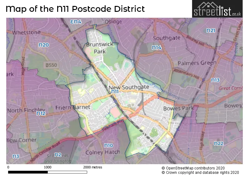
Map of the N11 Postcode District
Explore the postcode district by using our interactive map.
Circles represent recorded crime; the larger the circle, the higher the crime rates.


Your support helps keep this site running!
If you enjoy using this website, consider buying me a coffee to help cover hosting costs.
Where is the N11 District?
To give you an idea where the district is located we have created the following table showing nearby towns.
Nearest Towns to N11
| Town | Distance (miles) | Direction |
|---|---|---|
| Potters Bar | 6.02 | NNW |
| Borehamwood | 6.36 | WNW |
| Waltham Cross | 6.75 | NE |
| City of London | 7.23 | SSE |
| Cheshunt | 7.40 | NE |
| City of Westminster | 7.88 | S |
| Waltham Abbey | 8.39 | NE |
| Radlett | 9.02 | WNW |
| Chigwell | 9.31 | E |
| Loughton | 9.37 | ENE |
| Bushey | 9.86 | WNW |
| Hatfield | 10.95 | NNW |
| Watford | 11.33 | WNW |
| Hoddesdon | 11.37 | NNE |
| Epping | 12.25 | ENE |
| St Albans | 12.78 | NW |
| Hertford | 12.90 | NNE |
| Welwyn Garden City | 13.38 | NNW |
| Rickmansworth | 14.24 | W |
| Ware | 14.51 | NNE |
The post town for this district is LONDON.
Postcode Information for District N11 (Total Geographical Postcodes: 600)
| Location | Post Town | Sector | Number of Postcodes |
|---|---|---|---|
| Barnet | LONDON | N11 3 | 191 |
| Haringey | LONDON | N11 2 | 119 |
| Barnet | LONDON | N11 1 | 103 |
| Enfield | LONDON | N11 1 | 95 |
| Enfield | LONDON | N11 2 | 91 |
| Enfield | LONDON | N11 3 | 1 |
Retail and Shopping in N11
| Street | Town | Locality | Number of Shops | Central Postcode | View on Google Maps |
|---|---|---|---|---|---|
| FRIERN BARNET ROAD | LONDON | 60 | N11 3EU | View on Google Maps | |
| BOWES ROAD | LONDON | 58 | N11 1AA | View on Google Maps | |
| BOUNDS GREEN ROAD | LONDON | 16 | N11 2EU | View on Google Maps | |
| BROWNLOW ROAD | LONDON | 14 | N11 2DN | View on Google Maps | |
| PEGASUS WAY | LONDON | 14 | N11 3PW | View on Google Maps | |
| BRUNSWICK PARK ROAD | LONDON | 6 | N11 1JJ | View on Google Maps | |
| OAKLEIGH ROAD SOUTH | LONDON | 6 | N11 1NH | View on Google Maps |
The primary settlement in the N11 postcode district is Barnet, located in the county of Greater London. The post town for this district is London. Other significant settlements include Enfield and Haringey, also located in Greater London.
When it comes to local government, postal geography often disregards political borders. However, this district intersects the following councils: the district mostly encompasses the Barnet London Boro (294 postal codes), followed by the Enfield London Boro area (200 postal codes), and finally, the Haringey London Boro area (119 postal codes).
The largest settlement in the N11 postal code is NEW SOUTHGATE followed by SOUTHGATE, and WOOD GREEN.
The N11 Postcode shares a border with N10 (HORNSEY, MUSWELL HILL), N12 (NORTH FINCHLEY), N13 (SOUTHGATE), N14 (SOUTHGATE, NEW SOUTHGATE), N20 (WHETSTONE) and N22 (WOOD GREEN).


Dentists in the N11 District
| # | Name | Address | Type | Contact |
|---|---|---|---|---|
| 1 | Brightside Dental | 4-6 MAIDSTONE ROAD , LONDON , GREATER LONDON , N11 2TP | GENERAL DENTAL PRACTICE | |
| 2 | Perfect Teeth | 324 BOWES ROAD , LONDON , GREATER LONDON , N11 1AT | GENERAL DENTAL PRACTICE | |
| 3 | Bowes Road Dental Practice | 3 CHILTERN COURT , 359 BOWES ROAD , LONDON , GREATER LONDON , N11 1AF | GENERAL DENTAL PRACTICE | |
| 4 | 143 Durnsford Road [dental Practice] | 143 DURNSFORD ROAD , LONDON , GREATER LONDON , N11 2EL | GENERAL DENTAL PRACTICE | |
| 5 | Friern Barnet Dental Clinic | 21 QUEENS PARADE , FRIERN BARNET ROAD , LONDON , GREATER LONDON , N11 3DA | GENERAL DENTAL PRACTICE | |
| 6 | Eyes & Smiles | 53 FRIERN BARNET ROAD , LONDON , GREATER LONDON , N11 3EG | GENERAL DENTAL PRACTICE |
Doctors in the N11 District
| # | Name | Address | Type | Contact |
|---|---|---|---|---|
| 1 | Singh Rr | , BOUNDS GREEN , GREATER LONDON , N11 2HU | BRANCH SURGERY | |
| 2 | Brunswick Park Medical Practice | , NEW SOUTHGATE , LONDON , GREATER LONDON , N11 1EY | GP PRACTICE | |
| 3 | Friern Barnet Medical Centre | , FRIERN BARNET ROAD , LONDON , GREATER LONDON , N11 3BU | GP PRACTICE | |
| 4 | Bounds Green Group Practice | , GORDON ROAD, BOUNDS GREEN , NEW SOUTHGATE , LONDON , GREATER LONDON , N11 2PF | GP PRACTICE | |
| 5 | Arnos Grove Medical Centr | , NEW SOUTHGATE , LONDON , GREATER LONDON , N11 1BD | GP PRACTICE | |
| 6 | Bounds Green Group Practice - Covid Local Vaccination Service 2 | , GORDON ROAD , BOUNDS GREEN, NEW SOUTHGATE , LONDON , GREATER LONDON , N11 2PF | BRANCH SURGERY |
Chemists in the N11 District
| # | Name | Address | Type | Contact |
|---|---|---|---|---|
| 1 | Coopers Chemist | 364 BOWES ROAD , LONDON , GREATER LONDON , N11 1AH | PHARMACY | |
| 2 | Clockwork Pharmacy | 9 QUEENS PARADE , BROWNLOW ROAD , BOUNDS GREEN , LONDON , GREATER LONDON , N11 2DN | PHARMACY | |
| 3 | H Haria Chemists | 25 FRIERN BARNET ROAD , NEW SOUTHGATE , LONDON , GREATER LONDON , N11 1NE | PHARMACY | |
| 4 | Warwick Pharmacy | 48-50 BOUNDS GREEN ROAD , NORTH SOUTHGATE , LONDON , N11 2EU | PHARMACY | |
| 5 | Caplet Pharmacy | 133-135 HIGH ROAD , LONDON , N11 1PP | PHARMACY |
Opticians in the N11 District
| # | Name | Address | Type | Contact |
|---|---|---|---|---|
| 1 | OLIVIER OPTICIAN | 355 BOWES ROAD , NEW SOUTHGATE , LONDON , GREATER LONDON , N11 1AA | OPTICAL SITE | |
| 2 | A A BAKER OPTOMETRISTS | 157 BOWES ROAD , NEW SOUTHGATE , LONDON , GREATER LONDON , N11 2JA | OPTICAL SITE | |
| 3 | H.R. HARIA | 53 FRIERN BARNET ROAD , NEW SOUTHGATE , LONDON , GREATER LONDON , N11 3EG | OPTICAL SITE | |
| 4 | A.A. BAKER OPTICAL | 157 BOWES ROAD , LONDON , N11 2JA | OPTICAL SITE |
Schools in the Sector
Focus 1st Academy
Phase: Not applicable
Address: 339 Bowes Road , New Southgate , London
Postcode: N11 1BA
Headteacher: Ms Marina Savva ()
Ofsted Rating: Requires improvement
Garfield Primary School
Phase: Primary
Address: Upper Park Road , New Southgate , Enfield , London
Postcode: N11 1BH
Headteacher: Mr David Joyce (Headteacher)
Ofsted Rating: Good
St Andrew the Apostle Greek Orthodox School
Phase: Secondary
Address: North London Business Park , London
Postcode: N11 1NP
Headteacher: Dr Philip Hills (Headteacher)
Ofsted Rating: Good
St Paul's CofE Primary School N11
Phase: Primary
Address: The Avenue , Friern Barnet , London
Postcode: N11 1NQ
Headteacher: Ms J Levison (Headteacher)
Ofsted Rating: Good
Our Lady of Lourdes Catholic Primary School
Phase: Primary
Address: The Limes Avenue , London
Postcode: N11 1RD
Headteacher: Mrs Gillian Hood (Headteacher)
Ofsted Rating: Good
St Martin of Porres Catholic Primary School
Phase: Primary
Address: Blake Road , New Southgate , London
Postcode: N11 2AF
Headteacher: Ms Anne Thomas (Headteacher)
Ofsted Rating: Good
Alexandra Park School
Phase: Secondary
Address: Bidwell Gardens , London
Postcode: N11 2AZ
Headteacher: Mr Michael McKenzie (Headteacher)
Ofsted Rating: Outstanding
Bowes Primary School
Phase: Primary
Address: Bowes Road , New Southgate , London
Postcode: N11 2HL
Headteacher: Ms S Turner (Executive Headteacher)
Ofsted Rating: Outstanding
Bounds Green Junior School
Phase: Primary
Address: Bounds Green Road , London
Postcode: N11 2QG
Headteacher: Mrs Nadine Lewis (Headteacher)
Ofsted Rating: Good
Bounds Green Infant School
Phase: Primary
Address: Bounds Green Road , London
Postcode: N11 2QG
Headteacher: Mrs Nadine Lewis (Headteacher)
Ofsted Rating: Outstanding
Holly Park Primary School
Phase: Primary
Address: Bellevue Road , Friern Barnet , London
Postcode: N11 3HG
Headteacher: Mrs Ann Pelham (Headteacher)
Ofsted Rating: Good
St John's CofE Junior Mixed and Infant School
Phase: Primary
Address: Crescent Road , Friern Barnet , London
Postcode: N11 3LB
Headteacher: Mr Graham Gunn (Head Teacher)
Ofsted Rating: Good
Friern Barnet School
Phase: Secondary
Address: Hemington Avenue , Friern Barnet , London
Postcode: N11 3LS
Headteacher: Mr Simon Horne (Head Teacher)
Ofsted Rating: Good
Stations in the Sector
New Southgate
CRS Code: NSG
Operator: GN
Line: East Coast Main Line
Company: Govia Thameslink Railway (Great Northern)
Accessable Motorway Junctions
M1 J1
Average Driving Time from within the district: 9.75
Average Driving Distance: 5.90
Number of Postcodes that can access the Motorway Junction: 605
M25 J24
Average Driving Time from within the district: 11.71
Average Driving Distance: 5.90
Number of Postcodes that can access the Motorway Junction: 605
A1(M) J1
Average Driving Time from within the district: 11.92
Average Driving Distance: 6.58
Number of Postcodes that can access the Motorway Junction: 255
M25 J25
Average Driving Time from within the district: 12.37
Average Driving Distance: 7.26
Number of Postcodes that can access the Motorway Junction: 350
M25 J23
Average Driving Time from within the district: 12.96
Average Driving Distance: 7.06
Number of Postcodes that can access the Motorway Junction: 551
Weather Forecast for Wood Green
| Time Period | Icon | Description | Temperature | Rain Probability | Wind |
|---|---|---|---|---|---|
| 15:00 to 18:00 | Partly cloudy (day) | 4.0°C (feels like 3.0°C) | 2.00% | SSE 2 mph | |
| 18:00 to 21:00 | Cloudy | 3.0°C (feels like 1.0°C) | 8.00% | SSE 2 mph | |
| 21:00 to 00:00 | Cloudy | 3.0°C (feels like 1.0°C) | 5.00% | S 4 mph |
| Time Period | Icon | Description | Temperature | Rain Probability | Wind |
|---|---|---|---|---|---|
| 00:00 to 03:00 | Cloudy | 3.0°C (feels like 1.0°C) | 6.00% | S 4 mph | |
| 03:00 to 06:00 | Cloudy | 2.0°C (feels like 0.0°C) | 5.00% | S 4 mph | |
| 06:00 to 09:00 | Cloudy | 2.0°C (feels like 0.0°C) | 5.00% | S 7 mph | |
| 09:00 to 12:00 | Cloudy | 3.0°C (feels like 0.0°C) | 5.00% | SSW 7 mph | |
| 12:00 to 15:00 | Cloudy | 5.0°C (feels like 3.0°C) | 5.00% | SSW 7 mph | |
| 15:00 to 18:00 | Cloudy | 5.0°C (feels like 3.0°C) | 5.00% | SSW 9 mph | |
| 18:00 to 21:00 | Cloudy | 4.0°C (feels like 1.0°C) | 6.00% | SSW 9 mph | |
| 21:00 to 00:00 | Cloudy | 4.0°C (feels like 0.0°C) | 6.00% | SW 9 mph |
| Time Period | Icon | Description | Temperature | Rain Probability | Wind |
|---|---|---|---|---|---|
| 00:00 to 03:00 | Cloudy | 4.0°C (feels like 1.0°C) | 7.00% | SW 7 mph | |
| 03:00 to 06:00 | Overcast | 4.0°C (feels like 1.0°C) | 11.00% | SW 7 mph | |
| 06:00 to 09:00 | Overcast | 5.0°C (feels like 2.0°C) | 12.00% | SW 7 mph | |
| 09:00 to 12:00 | Overcast | 5.0°C (feels like 3.0°C) | 12.00% | WSW 7 mph | |
| 12:00 to 15:00 | Overcast | 7.0°C (feels like 6.0°C) | 11.00% | WSW 7 mph | |
| 15:00 to 18:00 | Overcast | 8.0°C (feels like 7.0°C) | 9.00% | WSW 7 mph | |
| 18:00 to 21:00 | Overcast | 8.0°C (feels like 6.0°C) | 10.00% | WSW 7 mph | |
| 21:00 to 00:00 | Overcast | 7.0°C (feels like 5.0°C) | 10.00% | WSW 7 mph |
| Time Period | Icon | Description | Temperature | Rain Probability | Wind |
|---|---|---|---|---|---|
| 00:00 to 03:00 | Overcast | 7.0°C (feels like 5.0°C) | 12.00% | WSW 7 mph | |
| 03:00 to 06:00 | Overcast | 6.0°C (feels like 4.0°C) | 12.00% | WSW 7 mph | |
| 06:00 to 09:00 | Overcast | 6.0°C (feels like 4.0°C) | 12.00% | WSW 7 mph | |
| 09:00 to 12:00 | Mist | 7.0°C (feels like 4.0°C) | 17.00% | WSW 7 mph | |
| 12:00 to 15:00 | Overcast | 8.0°C (feels like 6.0°C) | 10.00% | WSW 7 mph | |
| 15:00 to 18:00 | Cloudy | 9.0°C (feels like 7.0°C) | 6.00% | WSW 7 mph | |
| 18:00 to 21:00 | Cloudy | 8.0°C (feels like 6.0°C) | 6.00% | WSW 7 mph | |
| 21:00 to 00:00 | Cloudy | 7.0°C (feels like 5.0°C) | 7.00% | WSW 7 mph |
| Postal Sector | Delivery Office |
|---|---|
| N11 1 | New Southgate Sdelivery Office |
| N11 2 | New Southgate Sdelivery Office |
| N11 3 | New Southgate Sdelivery Office |
| N | 1 | 1 | - | X | X | X |
| N | 1 | 1 | Space | Numeric | Letter | Letter |
Street List for the N11 District
Current Monthly Rental Prices
| # Bedrooms | Min Price | Max Price | Avg Price |
|---|---|---|---|
| £1,000 | £1,300 | £1,200 | |
| 1 | £1,295 | £1,700 | £1,459 |
| 2 | £1,600 | £5,000 | £2,311 |
| 3 | £1,875 | £3,500 | £2,514 |
| 4 | £2,700 | £10,001 | £4,643 |
Current House Prices
| # Bedrooms | Min Price | Max Price | Avg Price |
|---|---|---|---|
| £160,000 | £475,000 | £263,750 | |
| 1 | £250,000 | £575,000 | £328,500 |
| 2 | £166,000 | £875,000 | £436,388 |
| 3 | £369,950 | £1,100,000 | £617,129 |
| 4 | £550,000 | £1,399,000 | £888,677 |
| 5 | £650,000 | £1,450,000 | £993,325 |
| 6 | £1,000,000 | £1,430,000 | £1,215,000 |
Estate Agents
| Logo | Name | Brand Name | Address | Contact Number |
|---|---|---|---|---|
 | Ouali Chriqy MNAEA - Personal Estate Agent | Ouali Chriqy MNAEA - Personal Estate Agent | Queensland Avenue, London N18 1AU | 07832 145 500 |
 | North Finchley | Foxtons | 811 High Road, London, N12 8JT | 020 3889 9109 |
 | London | Oyster Properties | 329 Bowes Road, London, N11 1BA | 020 3910 6720 |
 | Bounds Green | Ellis & Co | 10 Queens Parade, Brownlow Road, London, N11 2DN | 020 3835 5915 |
 | Muswell Hill | Dexters | 418 Muswell Hill Broadway, London, N10 1DJ | 020 8444 9914 |
Yearly House Price Averages for the District
| Type of Property | 2018 Average | 2018 Sales | 2017 Average | 2017 Sales | 2016 Average | 2016 Sales | 2015 Average | 2015 Sales |
|---|---|---|---|---|---|---|---|---|
| Detached | £513,357 | 2 | £676,000 | 5 | £862,778 | 9 | £744,688 | 8 |
| Semi-Detached | £700,245 | 44 | £705,102 | 52 | £703,636 | 46 | £649,219 | 49 |
| Terraced | £574,550 | 115 | £560,894 | 98 | £578,495 | 116 | £547,317 | 121 |
| Flats | £365,021 | 123 | £372,366 | 129 | £351,683 | 163 | £342,566 | 205 |