A wide range of spatial data has been analysed to present this overview of the N10 1 Postcode sector. If you would like anything added, please contact us.
The N10 1 postcode sector is within the county of Greater London.
Did you know? According to the 2021 Census, the N10 1 postcode sector is home to a bustling 8,864 residents!
Given that each sector allows for 400 unique postcode combinations. Letters C, I, K, M, O and V are not allowed in the last two letters of a postcode. With 148 postcodes already in use, this leaves 252 units available.
The largest settlement in the N10 1 postal code is HORNSEY followed by MUSWELL HILL , and COLNEY HATCH .
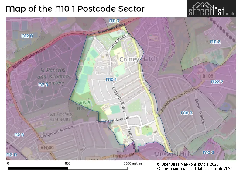
The N10 1 Postcode shares a border with N2 9 (EAST FINCHLEY , HORNSEY ), N10 2 (HORNSEY , MUSWELL HILL ), N10 3 (HORNSEY ), N11 3 (NEW SOUTHGATE , FRIERN BARNET , COLNEY HATCH ) and N12 0 (NORTH FINCHLEY , COLNEY HATCH , FINCHLEY ).
Map of the N10 1 Postcode Sector
Explore the N10 1 postcode sector by using our interactive map.
The sector is within the post town of LONDON.
N10 1 is a postcode sector within the N10 postcode district which is within the N North London postcode area.
The Royal Mail delivery office for the N10 1 postal sector is the Muswell Hill Sdelivery Office.
The area of the N10 1 postcode sector is 0.50 square miles which is 1.29 square kilometres or 318.31 square acres.
Your support helps keep this site running!
If you enjoy using this website, consider buying me a coffee to help cover hosting costs.

| N | 1 | 0 | - | 1 | X | X |
| N | 1 | 0 | Space | 1 | Letter | Letter |
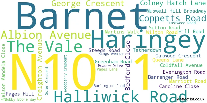
Official List of Streets
Barnet (12 Streets)
Haringey (23 Streets)
(3 Streets)
Unofficial Streets or Alternative Spellings
Haringey
ALEXANDRA PARK ROAD BARNARD HILL CAROLINE CLOSE DUKES AVENUE DUKES MEWS MUSWELL MEWS MUSWELL ROAD QUEENS AVENUE GILSON PLACE GOODWYNS VALE HARWOODS PATH HIGH VIEW ROAD JOINT ROAD PINKHAM WAY NORTH CIRCULAR ROAD RALEIGH ROAD STRAIGHT PATHBarnet
CREIGHTON AVENUE CROMWELL ROAD HAMPDEN ROAD PEMBROKE ROAD PINKHAM WAY SYDNEY ROAD WETHERILL ROADWeather Forecast for N10 1
Weather Forecast for Wood Green
| Time Period | Icon | Description | Temperature | Rain Probability | Wind |
|---|---|---|---|---|---|
| 18:00 to 21:00 | Clear night | 5.0°C (feels like 4.0°C) | 0.00% | SSW 4 mph | |
| 21:00 to 00:00 | Clear night | 3.0°C (feels like 2.0°C) | 0.00% | S 4 mph |
| Time Period | Icon | Description | Temperature | Rain Probability | Wind |
|---|---|---|---|---|---|
| 00:00 to 03:00 | Partly cloudy (night) | 2.0°C (feels like 1.0°C) | 1.00% | SSW 4 mph | |
| 03:00 to 06:00 | Cloudy | 2.0°C (feels like 0.0°C) | 4.00% | SW 4 mph | |
| 06:00 to 09:00 | Overcast | 3.0°C (feels like 1.0°C) | 8.00% | SSW 4 mph | |
| 09:00 to 12:00 | Overcast | 4.0°C (feels like 2.0°C) | 9.00% | SSW 4 mph | |
| 12:00 to 15:00 | Overcast | 7.0°C (feels like 5.0°C) | 9.00% | SSW 7 mph | |
| 15:00 to 18:00 | Overcast | 8.0°C (feels like 7.0°C) | 8.00% | SSW 7 mph | |
| 18:00 to 21:00 | Cloudy | 7.0°C (feels like 5.0°C) | 5.00% | S 7 mph | |
| 21:00 to 00:00 | Cloudy | 7.0°C (feels like 4.0°C) | 5.00% | SSW 9 mph |
| Time Period | Icon | Description | Temperature | Rain Probability | Wind |
|---|---|---|---|---|---|
| 00:00 to 03:00 | Cloudy | 6.0°C (feels like 4.0°C) | 6.00% | SSW 9 mph | |
| 03:00 to 06:00 | Partly cloudy (night) | 6.0°C (feels like 4.0°C) | 3.00% | SSW 9 mph | |
| 06:00 to 09:00 | Overcast | 7.0°C (feels like 4.0°C) | 8.00% | SSW 9 mph | |
| 09:00 to 12:00 | Cloudy | 7.0°C (feels like 4.0°C) | 6.00% | SSW 11 mph | |
| 12:00 to 15:00 | Cloudy | 9.0°C (feels like 6.0°C) | 4.00% | SSW 11 mph | |
| 15:00 to 18:00 | Overcast | 10.0°C (feels like 7.0°C) | 11.00% | SSW 11 mph | |
| 18:00 to 21:00 | Light rain | 9.0°C (feels like 7.0°C) | 55.00% | SSW 11 mph | |
| 21:00 to 00:00 | Light rain shower (night) | 9.0°C (feels like 7.0°C) | 41.00% | WSW 9 mph |
| Time Period | Icon | Description | Temperature | Rain Probability | Wind |
|---|---|---|---|---|---|
| 00:00 to 03:00 | Clear night | 7.0°C (feels like 5.0°C) | 3.00% | WSW 9 mph | |
| 03:00 to 06:00 | Clear night | 6.0°C (feels like 3.0°C) | 0.00% | WSW 7 mph | |
| 06:00 to 09:00 | Clear night | 4.0°C (feels like 2.0°C) | 1.00% | W 7 mph | |
| 09:00 to 12:00 | Partly cloudy (day) | 4.0°C (feels like 2.0°C) | 1.00% | W 4 mph | |
| 12:00 to 15:00 | Cloudy | 7.0°C (feels like 6.0°C) | 4.00% | W 4 mph | |
| 15:00 to 18:00 | Cloudy | 8.0°C (feels like 7.0°C) | 4.00% | NW 4 mph | |
| 18:00 to 21:00 | Partly cloudy (night) | 6.0°C (feels like 5.0°C) | 1.00% | NW 4 mph | |
| 21:00 to 00:00 | Partly cloudy (night) | 4.0°C (feels like 3.0°C) | 1.00% | NNW 4 mph |
| Time Period | Icon | Description | Temperature | Rain Probability | Wind |
|---|---|---|---|---|---|
| 00:00 to 03:00 | Clear night | 3.0°C (feels like 2.0°C) | 1.00% | N 4 mph | |
| 03:00 to 06:00 | Clear night | 2.0°C (feels like 0.0°C) | 1.00% | NNE 4 mph | |
| 06:00 to 09:00 | Clear night | 1.0°C (feels like -1.0°C) | 1.00% | NNE 4 mph | |
| 09:00 to 12:00 | Sunny day | 2.0°C (feels like 0.0°C) | 1.00% | NE 4 mph | |
| 12:00 to 15:00 | Sunny day | 6.0°C (feels like 4.0°C) | 1.00% | NE 7 mph | |
| 15:00 to 18:00 | Sunny day | 8.0°C (feels like 5.0°C) | 1.00% | ENE 7 mph | |
| 18:00 to 21:00 | Clear night | 5.0°C (feels like 3.0°C) | 1.00% | NE 7 mph | |
| 21:00 to 00:00 | Clear night | 4.0°C (feels like 1.0°C) | 2.00% | NE 7 mph |
Schools and Places of Education Within the N10 1 Postcode Sector
Blanche Nevile School
Community special school
Burlington Road, London, , N10 1NJ
Head: Ms Helen Taylor
Ofsted Rating: Good
Inspection: 2023-02-03 (730 days ago)
Website: Visit Blanche Nevile School Website
Phone: 02084422750
Number of Pupils: 67
Coldfall Primary School
Community school
Coldfall Avenue, London, , N10 1HS
Head: Mr William Marshall
Ofsted Rating: Outstanding
Inspection: 2014-10-24 (3754 days ago)
Website: Visit Coldfall Primary School Website
Phone: 02088830608
Number of Pupils: 656
Coppetts Wood Primary School
Community school
Coppetts Road, London, , N10 1JS
Head: Ms Anna Lippa
Ofsted Rating: Requires improvement
Inspection: 2023-03-29 (676 days ago)
Website: Visit Coppetts Wood Primary School Website
Phone: 02088830248
Number of Pupils: 282
Eden Primary
Free schools
79 Creighton Avenue, London, , N10 1NR
Head: Mrs Helen Graff
Ofsted Rating: Good
Inspection: 2017-11-21 (2630 days ago)
Website: Visit Eden Primary Website
Phone: 02088839527
Number of Pupils: 203
Fortismere School
Foundation school
Southwing, London, , N10 1NE
Head: Ms Zoe Judge & Ms Jo Davey
Ofsted Rating: Good
Inspection: 2022-04-27 (1012 days ago)
Website: Visit Fortismere School Website
Phone: 02083654400
Number of Pupils: 1820
Our Lady of Muswell Catholic Primary School
Voluntary aided school
Pages Lane, London, , N10 1PS
Head: Mrs Angela McNicholas
Ofsted Rating: Outstanding
Inspection: 2017-11-29 (2622 days ago)
Website: Visit Our Lady of Muswell Catholic Primary School Website
Phone: 02084446894
Number of Pupils: 408
House Prices in the N10 1 Postcode Sector
| Type of Property | 2018 Average | 2018 Sales | 2017 Average | 2017 Sales | 2016 Average | 2016 Sales | 2015 Average | 2015 Sales |
|---|---|---|---|---|---|---|---|---|
| Detached | £0 | 0 | £1,503,333 | 3 | £1,560,000 | 2 | £1,060,521 | 3 |
| Semi-Detached | £966,786 | 21 | £890,417 | 12 | £971,875 | 16 | £840,622 | 16 |
| Terraced | £809,414 | 22 | £875,769 | 13 | £758,187 | 19 | £768,739 | 29 |
| Flats | £458,544 | 44 | £429,640 | 46 | £410,643 | 49 | £408,526 | 69 |
Important Postcodes N10 1 in the Postcode Sector
N10 1DW is the postcode for Royal Mail, Muswell Hill Delivery Office, 420 Muswell Hill Broadway
N10 1HS is the postcode for Coldfall Primary School, Coldfall Avenue, and Coldfall Primary School, Coldfall Avenue, Hornsey
N10 1JS is the postcode for Coppetts Wood School, Coppetts Road, Coppetts Wood Nursery School, Coppetts Road, and Coppetts Wood Primary School, Coppetts Road
N10 1NE is the postcode for Sports Hall, Fortismere Secondary School, Tetherdown, North Wing, Fortismere Secondary School, Tetherdown, TETHERDOWN BUILDING, Fortismere Secondary School, Tetherdown, Fortismere Secondary School, Tetherdown, CANTEEN, Fortismere Secondary School, Tetherdown, Finch, Fortismere Secondary School, Tetherdown, Music Block, Fortismere Secondary School, Tetherdown, SIXTH FORM CENTRE, Fortismere Secondary School, Tetherdown, South Wing, Fortismere Secondary School, Tetherdown, Science Department, Fortismere Secondary School, Tetherdown, and SOUTH WING & SCIENCE, Fortismere Secondary School, Tetherdown
N10 1NS is the postcode for PADDY HADDOW SPORTS CENTRE, Fortismere School North Wing, Creighton Avenue, and Fortismere School North Wing, Creighton Avenue
N10 1PS is the postcode for Our Lady of Muswell RC Primary School, Pages Lane
| The N10 1 Sector is within these Local Authorities |
|
|---|---|
| The N10 1 Sector is within these Counties |
|
| The N10 1 Sector is within these Water Company Areas |
|