A wide range of spatial data has been analysed to present this overview of the N1 3 Postcode sector. If you would like anything added, please contact us.
The N1 3 postcode sector is within the county of Greater London.
Did you know? According to the 2021 Census, the N1 3 postcode sector is home to a bustling 8,718 residents!
Given that each sector allows for 400 unique postcode combinations. Letters C, I, K, M, O and V are not allowed in the last two letters of a postcode. With 177 postcodes already in use, this leaves 223 units available.
The largest settlements in the N1 3 postal code are ISLINGTON and HACKNEY .
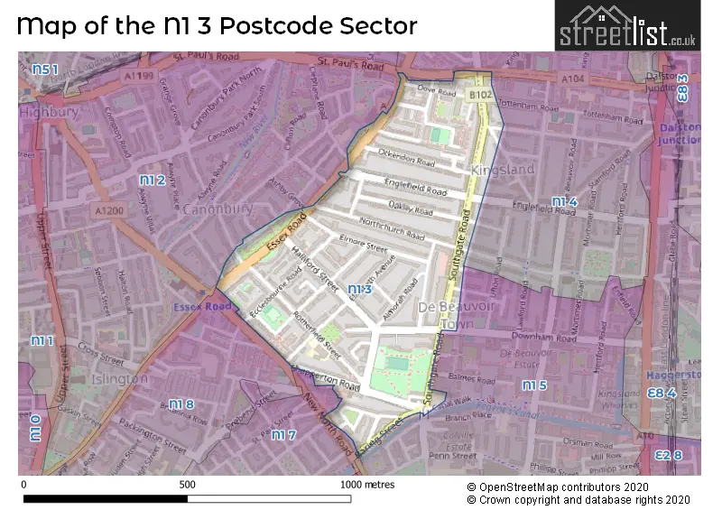
The N1 3 Postcode shares a border with N1 4 (ISLINGTON , HACKNEY ), N1 5 (HACKNEY ), N1 2 (ISLINGTON ), N1 8 (ISLINGTON ) and N1 7 (HACKNEY , ISLINGTON ).
Map of the N1 3 Postcode Sector
Explore the N1 3 postcode sector by using our interactive map.
The sector is within the post town of LONDON.
N1 3 is a postcode sector within the N1 postcode district which is within the N North London postcode area.
The Royal Mail delivery office for the N1 3 postal sector is the Islington Delivery Office.
The area of the N1 3 postcode sector is 0.21 square miles which is 0.54 square kilometres or 133.86 square acres.
Waterways within the N1 3 postcode sector include the Regent's Canal.
Your support helps keep this site running!
If you enjoy using this website, consider buying me a coffee to help cover hosting costs.


| N | 1 | - | 3 | X | X |
| N | 1 | Space | 3 | Letter | Letter |
Official List of Streets
Islington (42 Streets)
(3 Streets)
Unofficial Streets or Alternative Spellings
Hackney
ARDLEIGH ROAD BALLS POND ROAD BALMES ROAD BENYON ROAD BRIDPORT PLACE BUCKINGHAM ROAD CANAL WALK CULFORD MEWS DOWNHAM ROAD ENGLEFIELD ROAD NORTHCHURCH ROAD SOUTHGATE GROVE TOTTENHAM ROAD UFTON GROVEIslington
ASHBY GROVE CANONBURY CRESCENT CANONBURY STREET CLEPHANE ROAD MARQUESS ROAD MILDMAY PARK NORTHAMPTON STREET BUTE WALK DEACON MEWS FARRIERS YARD FLORENCE MEWS OCKENDON MEWS REGENTS CANAL TOWPATH ST PAULS ROADWeather Forecast for N1 3
Weather Forecast for Islington
| Time Period | Icon | Description | Temperature | Rain Probability | Wind |
|---|---|---|---|---|---|
| 03:00 to 06:00 | Cloudy | 5.0°C (feels like 1.0°C) | 12.00% | N 9 mph | |
| 06:00 to 09:00 | Cloudy | 3.0°C (feels like 0.0°C) | 9.00% | NNW 9 mph | |
| 09:00 to 12:00 | Sunny day | 3.0°C (feels like 0.0°C) | 1.00% | NW 7 mph | |
| 12:00 to 15:00 | Sunny day | 6.0°C (feels like 3.0°C) | 0.00% | NW 7 mph | |
| 15:00 to 18:00 | Sunny day | 7.0°C (feels like 5.0°C) | 0.00% | NW 7 mph | |
| 18:00 to 21:00 | Clear night | 5.0°C (feels like 4.0°C) | 0.00% | WNW 4 mph | |
| 21:00 to 00:00 | Clear night | 4.0°C (feels like 2.0°C) | 1.00% | WSW 4 mph |
| Time Period | Icon | Description | Temperature | Rain Probability | Wind |
|---|---|---|---|---|---|
| 00:00 to 03:00 | Cloudy | 3.0°C (feels like 1.0°C) | 3.00% | SW 4 mph | |
| 03:00 to 06:00 | Cloudy | 2.0°C (feels like 0.0°C) | 11.00% | SW 4 mph | |
| 06:00 to 09:00 | Overcast | 3.0°C (feels like 0.0°C) | 25.00% | SSW 4 mph | |
| 09:00 to 12:00 | Light rain | 4.0°C (feels like 1.0°C) | 58.00% | SSW 7 mph | |
| 12:00 to 15:00 | Light rain | 6.0°C (feels like 4.0°C) | 52.00% | SSW 7 mph | |
| 15:00 to 18:00 | Overcast | 7.0°C (feels like 5.0°C) | 13.00% | SSW 4 mph | |
| 18:00 to 21:00 | Overcast | 6.0°C (feels like 4.0°C) | 9.00% | SSE 4 mph | |
| 21:00 to 00:00 | Cloudy | 5.0°C (feels like 4.0°C) | 5.00% | S 4 mph |
| Time Period | Icon | Description | Temperature | Rain Probability | Wind |
|---|---|---|---|---|---|
| 00:00 to 03:00 | Cloudy | 4.0°C (feels like 3.0°C) | 6.00% | ESE 2 mph | |
| 03:00 to 06:00 | Overcast | 4.0°C (feels like 2.0°C) | 9.00% | ESE 2 mph | |
| 06:00 to 09:00 | Overcast | 3.0°C (feels like 1.0°C) | 9.00% | ESE 4 mph | |
| 09:00 to 12:00 | Cloudy | 4.0°C (feels like 2.0°C) | 6.00% | SE 4 mph | |
| 12:00 to 15:00 | Cloudy | 6.0°C (feels like 4.0°C) | 5.00% | SSE 7 mph | |
| 15:00 to 18:00 | Cloudy | 7.0°C (feels like 5.0°C) | 6.00% | SSE 7 mph | |
| 18:00 to 21:00 | Cloudy | 5.0°C (feels like 3.0°C) | 6.00% | SSE 7 mph | |
| 21:00 to 00:00 | Partly cloudy (night) | 4.0°C (feels like 2.0°C) | 3.00% | SSE 7 mph |
| Time Period | Icon | Description | Temperature | Rain Probability | Wind |
|---|---|---|---|---|---|
| 00:00 to 03:00 | Partly cloudy (night) | 4.0°C (feels like 1.0°C) | 3.00% | SSE 7 mph | |
| 03:00 to 06:00 | Partly cloudy (night) | 3.0°C (feels like 1.0°C) | 5.00% | SSE 7 mph | |
| 06:00 to 09:00 | Partly cloudy (night) | 3.0°C (feels like 0.0°C) | 8.00% | SSE 7 mph | |
| 09:00 to 12:00 | Cloudy | 3.0°C (feels like 1.0°C) | 10.00% | SSE 7 mph | |
| 12:00 to 15:00 | Cloudy | 6.0°C (feels like 4.0°C) | 12.00% | SSE 7 mph | |
| 15:00 to 18:00 | Sunny day | 6.0°C (feels like 5.0°C) | 10.00% | S 4 mph | |
| 18:00 to 21:00 | Cloudy | 5.0°C (feels like 3.0°C) | 10.00% | S 4 mph | |
| 21:00 to 00:00 | Partly cloudy (night) | 4.0°C (feels like 2.0°C) | 5.00% | S 4 mph |
Schools and Places of Education Within the N1 3 Postcode Sector
Rotherfield Primary School
Community school
Rotherfield Street, London, , N1 3EE
Head: Mrs Nia Silverwood
Ofsted Rating: Good
Inspection: 2023-04-19 (652 days ago)
Website: Visit Rotherfield Primary School Website
Phone: 02072266620
Number of Pupils: 335
House Prices in the N1 3 Postcode Sector
| Type of Property | 2018 Average | 2018 Sales | 2017 Average | 2017 Sales | 2016 Average | 2016 Sales | 2015 Average | 2015 Sales |
|---|---|---|---|---|---|---|---|---|
| Detached | £0 | 0 | £1,100,000 | 1 | £0 | 0 | £0 | 0 |
| Semi-Detached | £1,460,000 | 2 | £1,999,141 | 4 | £0 | 0 | £1,511,167 | 6 |
| Terraced | £1,428,909 | 11 | £1,270,278 | 18 | £1,330,385 | 13 | £1,284,422 | 15 |
| Flats | £549,719 | 78 | £621,251 | 74 | £612,706 | 70 | £584,088 | 110 |
Important Postcodes N1 3 in the Postcode Sector
N1 3AA is the postcode for Packington Childrens Centre, New Bentham Court, Ecclesbourne Road
N1 3AZ is the postcode for 292 Essex Road
N1 3EE is the postcode for Rotherfield Primary School, 23 Rotherfield Street
| The N1 3 Sector is within these Local Authorities |
|
|---|---|
| The N1 3 Sector is within these Counties |
|
| The N1 3 Sector is within these Water Company Areas |
|