A wide range of spatial data has been analysed to present this overview of the ME6 5 Postcode sector. If you would like anything added, please contact us.
The ME6 5 postcode sector is within the county of Kent.
Did you know? According to the 2021 Census, the ME6 5 postcode sector is home to a bustling 11,844 residents!
Given that each sector allows for 400 unique postcode combinations. Letters C, I, K, M, O and V are not allowed in the last two letters of a postcode. With 250 postcodes already in use, this leaves 150 units available.
The ME6 5 postal code covers the settlement of SNODLAND.
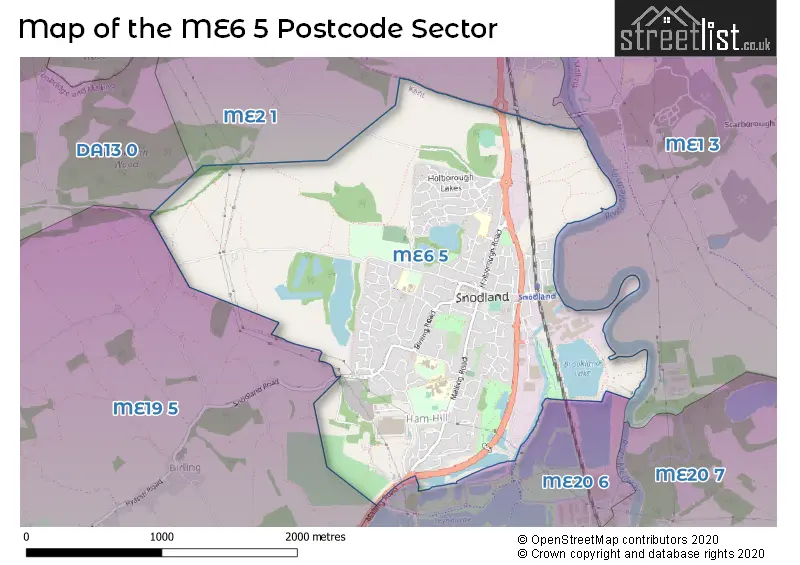
The ME6 5 Postcode shares a border with DA13 0 (Meopham, Vigo, Luddesdown), ME1 3 (ROCHESTER, Wouldham, Burham), ME2 1 (Halling, Cuxton, Upper Halling), ME19 5 (Leybourne, Addington, Ryarsh) and ME20 6 (Larkfield, Ditton).
Map of the ME6 5 Postcode Sector
Explore the ME6 5 postcode sector by using our interactive map.
The sector is within the post town of SNODLAND.
ME6 5 is a postcode sector within the ME6 postcode district which is within the ME Medway postcode area.
The Royal Mail delivery office for the ME6 5 postal sector is the Medway Valley Delivery Office.
The area of the ME6 5 postcode sector is 2.46 square miles which is 6.37 square kilometres or 1,573.17 square acres.
Your support helps keep this site running!
If you enjoy using this website, consider buying me a coffee to help cover hosting costs.


| M | E | 6 | - | 5 | X | X |
| M | E | 6 | Space | 5 | Letter | Letter |
Official List of Streets
SNODLAND (136 Streets)
Unofficial Streets or Alternative Spellings
Weather Forecast for ME6 5
Weather Forecast for East Malling
| Time Period | Icon | Description | Temperature | Rain Probability | Wind |
|---|---|---|---|---|---|
| 21:00 to 00:00 | Partly cloudy (night) | 1.0°C (feels like -1.0°C) | 1.00% | WSW 2 mph |
| Time Period | Icon | Description | Temperature | Rain Probability | Wind |
|---|---|---|---|---|---|
| 00:00 to 03:00 | Partly cloudy (night) | 0.0°C (feels like -3.0°C) | 0.00% | S 2 mph | |
| 03:00 to 06:00 | Partly cloudy (night) | -1.0°C (feels like -3.0°C) | 1.00% | SSW 2 mph | |
| 06:00 to 09:00 | Cloudy | 0.0°C (feels like -3.0°C) | 7.00% | SSW 2 mph | |
| 09:00 to 12:00 | Overcast | 2.0°C (feels like 0.0°C) | 7.00% | S 4 mph | |
| 12:00 to 15:00 | Cloudy | 6.0°C (feels like 4.0°C) | 6.00% | SSW 7 mph | |
| 15:00 to 18:00 | Cloudy | 8.0°C (feels like 6.0°C) | 8.00% | SSW 7 mph | |
| 18:00 to 21:00 | Overcast | 6.0°C (feels like 4.0°C) | 8.00% | S 7 mph | |
| 21:00 to 00:00 | Overcast | 6.0°C (feels like 3.0°C) | 8.00% | SSW 7 mph |
| Time Period | Icon | Description | Temperature | Rain Probability | Wind |
|---|---|---|---|---|---|
| 00:00 to 03:00 | Cloudy | 5.0°C (feels like 2.0°C) | 9.00% | SSW 7 mph | |
| 03:00 to 06:00 | Partly cloudy (night) | 6.0°C (feels like 3.0°C) | 3.00% | SSW 7 mph | |
| 06:00 to 09:00 | Cloudy | 6.0°C (feels like 2.0°C) | 5.00% | SSW 9 mph | |
| 09:00 to 12:00 | Cloudy | 6.0°C (feels like 3.0°C) | 5.00% | SSW 9 mph | |
| 12:00 to 15:00 | Partly cloudy (day) | 9.0°C (feels like 6.0°C) | 2.00% | SSW 13 mph | |
| 15:00 to 18:00 | Cloudy | 9.0°C (feels like 6.0°C) | 5.00% | SSW 11 mph | |
| 18:00 to 21:00 | Overcast | 9.0°C (feels like 6.0°C) | 21.00% | SSW 11 mph | |
| 21:00 to 00:00 | Light rain | 9.0°C (feels like 6.0°C) | 54.00% | SW 9 mph |
| Time Period | Icon | Description | Temperature | Rain Probability | Wind |
|---|---|---|---|---|---|
| 00:00 to 03:00 | Clear night | 7.0°C (feels like 5.0°C) | 8.00% | WSW 7 mph | |
| 03:00 to 06:00 | Clear night | 5.0°C (feels like 3.0°C) | 0.00% | W 7 mph | |
| 06:00 to 09:00 | Clear night | 4.0°C (feels like 1.0°C) | 0.00% | W 4 mph | |
| 09:00 to 12:00 | Partly cloudy (day) | 4.0°C (feels like 2.0°C) | 1.00% | W 4 mph | |
| 12:00 to 15:00 | Cloudy | 8.0°C (feels like 6.0°C) | 4.00% | WNW 7 mph | |
| 15:00 to 18:00 | Cloudy | 8.0°C (feels like 7.0°C) | 4.00% | NW 7 mph | |
| 18:00 to 21:00 | Cloudy | 5.0°C (feels like 4.0°C) | 4.00% | NNW 2 mph | |
| 21:00 to 00:00 | Partly cloudy (night) | 4.0°C (feels like 2.0°C) | 1.00% | N 4 mph |
| Time Period | Icon | Description | Temperature | Rain Probability | Wind |
|---|---|---|---|---|---|
| 00:00 to 03:00 | Partly cloudy (night) | 2.0°C (feels like 0.0°C) | 1.00% | N 4 mph | |
| 03:00 to 06:00 | Clear night | 2.0°C (feels like -1.0°C) | 1.00% | NNE 4 mph | |
| 06:00 to 09:00 | Clear night | 1.0°C (feels like -1.0°C) | 1.00% | NNE 4 mph | |
| 09:00 to 12:00 | Sunny day | 3.0°C (feels like 1.0°C) | 1.00% | NNE 4 mph | |
| 12:00 to 15:00 | Sunny day | 7.0°C (feels like 5.0°C) | 1.00% | NE 7 mph | |
| 15:00 to 18:00 | Sunny day | 8.0°C (feels like 5.0°C) | 2.00% | NE 9 mph | |
| 18:00 to 21:00 | Clear night | 5.0°C (feels like 2.0°C) | 2.00% | NE 7 mph | |
| 21:00 to 00:00 | Clear night | 4.0°C (feels like 1.0°C) | 2.00% | NE 7 mph |
Schools and Places of Education Within the ME6 5 Postcode Sector
Snodland CofE Primary School
Voluntary aided school
Roberts Road, Snodland, Kent, ME6 5HL
Head: Mrs Holley Hunt
Ofsted Rating: Good
Inspection: 2022-10-19 (837 days ago)
Website: Visit Snodland CofE Primary School Website
Phone: 01634241251
Number of Pupils: 407
Valley Invicta Primary School at Holborough Lakes
Academy sponsor led
Holborough Lakes, Snodland, Kent, ME6 5GR
Head: Mrs Lisa Vickers
Ofsted Rating: Good
Inspection: 2018-10-04 (2313 days ago)
Website: Visit Valley Invicta Primary School at Holborough Lakes Website
Phone: 01634242839
Number of Pupils: 228
House Prices in the ME6 5 Postcode Sector
| Type of Property | 2018 Average | 2018 Sales | 2017 Average | 2017 Sales | 2016 Average | 2016 Sales | 2015 Average | 2015 Sales |
|---|---|---|---|---|---|---|---|---|
| Detached | £449,919 | 40 | £418,003 | 41 | £388,111 | 27 | £365,997 | 19 |
| Semi-Detached | £352,407 | 62 | £301,508 | 95 | £288,774 | 50 | £251,600 | 60 |
| Terraced | £268,091 | 88 | £273,455 | 106 | £230,024 | 107 | £208,995 | 116 |
| Flats | £206,366 | 53 | £160,061 | 48 | £206,489 | 69 | £142,580 | 30 |
Important Postcodes ME6 5 in the Postcode Sector
ME6 5EJ is the postcode for KEY STAGE 1, St. Katherines School, St. Katherines Lane, NURSERY BLOCK, St. Katherines School, St. Katherines Lane, and St. Katherines School, St. Katherines Lane
ME6 5GP is the postcode for Royal Mail, Medway Valley Delivery Office, Sortmill Road
ME6 5GR is the postcode for Valley Invicta Primary School, 3 Pollyfield Close, VALLEY INVICTA PRIMARY SCHOOL, 3 POLLYFIELD CLOSE, SNODLAND, and Holborough Lakes Primary School, Pollyfield Close
ME6 5HL is the postcode for Snodland Cp School, Roberts Road, LARCH BLOCK, Snodland Cp School, Roberts Road, and OAK BLOCK, Snodland Cp School, Roberts Road
ME6 5HS is the postcode for TB4 & C2, Holmesdale Technology College, Malling Road, THE WOLFE CENTRE, Holmesdale Technology College, Malling Road, Holmesdale Technology College, Malling Road, Modular Classroom Block, Five Acre Wood School, Malling Road, TB2, Holmesdale Technology College, Malling Road, C1 & GYM GORDON BUILDING, Holmesdale Technology College, Malling Road, C1, Holmesdale Technology College, Malling Road, The Wolfe Building, Five Acre Wood School, Malling Road, and TB3, Holmesdale Technology College, Malling Road
ME6 5SN is the postcode for Snodland Medical Practice, Catts Alley
| The ME6 5 Sector is within these Local Authorities |
|
|---|---|
| The ME6 5 Sector is within these Counties |
|
| The ME6 5 Sector is within these Water Company Areas |
|