A wide range of spatial data has been analysed to present this overview of the ME5 8 Postcode sector. If you would like anything added, please contact us.
The ME5 8 postcode sector is within the county of Kent.
Did you know? According to the 2021 Census, the ME5 8 postcode sector is home to a bustling 15,222 residents!
Given that each sector allows for 400 unique postcode combinations. Letters C, I, K, M, O and V are not allowed in the last two letters of a postcode. With 287 postcodes already in use, this leaves 113 units available.
The ME5 8 postal code covers the settlement of CHATHAM.
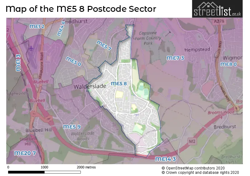
The ME5 8 Postcode shares a border with ME5 0 (CHATHAM), ME5 7 (CHATHAM), ME5 9 (CHATHAM, Walderslade, Blue Bell Hill), ME7 3 (Hempstead, GILLINGHAM, Bredhurst) and ME14 3 (Detling, Sandling, Boxley).
Map of the ME5 8 Postcode Sector
Explore the ME5 8 postcode sector by using our interactive map.
The sector is within the post town of CHATHAM.
ME5 8 is a postcode sector within the ME5 postcode district which is within the ME Medway postcode area.
The Royal Mail delivery office for the ME5 8 postal sector is the Chatham Delivery Office.
The area of the ME5 8 postcode sector is 1.31 square miles which is 3.39 square kilometres or 838.14 square acres.
The ME5 8 postcode sector is crossed by the M2 motorway.
Your support helps keep this site running!
If you enjoy using this website, consider buying me a coffee to help cover hosting costs.


| M | E | 5 | - | 8 | X | X |
| M | E | 5 | Space | 8 | Letter | Letter |
Official List of Streets
CHATHAM (168 Streets)
Unofficial Streets or Alternative Spellings
Weather Forecast for ME5 8
Weather Forecast for Chatham Ski Centre
| Time Period | Icon | Description | Temperature | Rain Probability | Wind |
|---|---|---|---|---|---|
| 09:00 to 12:00 | Overcast | 4.0°C (feels like 2.0°C) | 8.00% | SSE 7 mph | |
| 12:00 to 15:00 | Cloudy | 6.0°C (feels like 3.0°C) | 5.00% | SSE 9 mph | |
| 15:00 to 18:00 | Partly cloudy (day) | 6.0°C (feels like 3.0°C) | 1.00% | SSE 9 mph | |
| 18:00 to 21:00 | Clear night | 3.0°C (feels like 1.0°C) | 1.00% | SSE 7 mph | |
| 21:00 to 00:00 | Clear night | 2.0°C (feels like -1.0°C) | 1.00% | SSE 7 mph |
| Time Period | Icon | Description | Temperature | Rain Probability | Wind |
|---|---|---|---|---|---|
| 00:00 to 03:00 | Clear night | 2.0°C (feels like -2.0°C) | 1.00% | SSE 7 mph | |
| 03:00 to 06:00 | Clear night | 1.0°C (feels like -2.0°C) | 1.00% | SSE 7 mph | |
| 06:00 to 09:00 | Clear night | 0.0°C (feels like -3.0°C) | 1.00% | SSE 7 mph | |
| 09:00 to 12:00 | Sunny day | 2.0°C (feels like -1.0°C) | 1.00% | SSE 7 mph | |
| 12:00 to 15:00 | Sunny day | 5.0°C (feels like 3.0°C) | 1.00% | SSE 7 mph | |
| 15:00 to 18:00 | Sunny day | 6.0°C (feels like 4.0°C) | 2.00% | S 4 mph | |
| 18:00 to 21:00 | Clear night | 2.0°C (feels like 0.0°C) | 2.00% | S 4 mph | |
| 21:00 to 00:00 | Clear night | 1.0°C (feels like -1.0°C) | 2.00% | SSW 4 mph |
| Time Period | Icon | Description | Temperature | Rain Probability | Wind |
|---|---|---|---|---|---|
| 00:00 to 03:00 | Clear night | 0.0°C (feels like -2.0°C) | 2.00% | SSW 4 mph | |
| 03:00 to 06:00 | Clear night | 0.0°C (feels like -2.0°C) | 4.00% | SSW 4 mph | |
| 06:00 to 09:00 | Clear night | 0.0°C (feels like -2.0°C) | 4.00% | SSW 4 mph | |
| 09:00 to 12:00 | Mist | 2.0°C (feels like 0.0°C) | 14.00% | SSW 4 mph | |
| 12:00 to 15:00 | Partly cloudy (day) | 6.0°C (feels like 3.0°C) | 2.00% | SSW 9 mph | |
| 15:00 to 18:00 | Partly cloudy (day) | 7.0°C (feels like 5.0°C) | 2.00% | SSW 9 mph | |
| 18:00 to 21:00 | Partly cloudy (night) | 4.0°C (feels like 1.0°C) | 2.00% | SSW 7 mph | |
| 21:00 to 00:00 | Partly cloudy (night) | 4.0°C (feels like 0.0°C) | 3.00% | SSW 9 mph |
| Time Period | Icon | Description | Temperature | Rain Probability | Wind |
|---|---|---|---|---|---|
| 00:00 to 03:00 | Partly cloudy (night) | 4.0°C (feels like 1.0°C) | 2.00% | SSW 9 mph | |
| 03:00 to 06:00 | Partly cloudy (night) | 4.0°C (feels like 1.0°C) | 3.00% | SSW 9 mph | |
| 06:00 to 09:00 | Partly cloudy (night) | 4.0°C (feels like 1.0°C) | 4.00% | SSW 9 mph | |
| 09:00 to 12:00 | Cloudy | 6.0°C (feels like 2.0°C) | 9.00% | S 11 mph | |
| 12:00 to 15:00 | Cloudy | 8.0°C (feels like 5.0°C) | 10.00% | SSW 13 mph | |
| 15:00 to 18:00 | Cloudy | 9.0°C (feels like 6.0°C) | 13.00% | SSW 11 mph | |
| 18:00 to 21:00 | Cloudy | 7.0°C (feels like 4.0°C) | 17.00% | SSW 11 mph | |
| 21:00 to 00:00 | Partly cloudy (night) | 7.0°C (feels like 4.0°C) | 13.00% | SW 9 mph |
Schools and Places of Education Within the ME5 8 Postcode Sector
Lordswood School
Academy sponsor led
Lordswood Lane, Chatham, Kent, ME5 8NN
Head: Mrs Jayne Lusinski
Ofsted Rating: Good
Inspection: 2019-01-16 (2208 days ago)
Website: Visit Lordswood School Website
Phone: 01634336767
Number of Pupils: 410
Swingate Primary School
Community school
Sultan Road, Chatham, Kent, ME5 8TJ
Head: Mr Steven Geary
Ofsted Rating: Good
Inspection: 2018-11-08 (2277 days ago)
Website: Visit Swingate Primary School Website
Phone: 01634863778
Number of Pupils: 659
Walderslade Primary School
Academy converter
Dargets Road, Chatham, Kent, ME5 8BJ
Head: Mrs Amy Rowley-Jones
Ofsted Rating: Good
Inspection: 2018-11-21 (2264 days ago)
Website: Visit Walderslade Primary School Website
Phone: 01634337766
Number of Pupils: 235
House Prices in the ME5 8 Postcode Sector
| Type of Property | 2018 Average | 2018 Sales | 2017 Average | 2017 Sales | 2016 Average | 2016 Sales | 2015 Average | 2015 Sales |
|---|---|---|---|---|---|---|---|---|
| Detached | £377,926 | 27 | £365,943 | 35 | £338,012 | 41 | £326,813 | 40 |
| Semi-Detached | £273,819 | 79 | £258,887 | 89 | £264,146 | 72 | £219,480 | 71 |
| Terraced | £230,699 | 114 | £225,434 | 110 | £210,401 | 131 | £184,385 | 134 |
| Flats | £152,645 | 29 | £144,289 | 37 | £138,689 | 18 | £114,589 | 18 |
Important Postcodes ME5 8 in the Postcode Sector
ME5 8BJ is the postcode for Walderslade Primary School, Dargets Road, Walderslade, and Walderslade Primary School, Dargets Road
ME5 8NN is the postcode for Lordswood Junior School, Lords Wood Lane, Lordswood School, Lordswood Lane, Lordswood, Lordswood Infant School, Lords Wood Lane, and Lordswood School, Lordswood Lane
ME5 8PU is the postcode for St. Benedicts Roman Catholic Primary School, Lambourn Way, and ST BENEDICTS RC PRIMARY SCHOOL, LAMBOURN WAY, LORDSWOOD
ME5 8TH is the postcode for Medway Council, Lordswood Library, Kestrel Road
ME5 8TJ is the postcode for Swingate Infant School, Sultan Road, Lordswood Healthy Living Centre, Sultan Road, Swingate Primary School, Sultan Road, and Spinnens Acre Junior School, Sultan Road
| The ME5 8 Sector is within these Local Authorities |
|
|---|---|
| The ME5 8 Sector is within these Counties |
|
| The ME5 8 Sector is within these Water Company Areas |
|