A wide range of spatial data has been analysed to present this overview of the ME13 9 Postcode sector. If you would like anything added, please contact us.
The ME13 9 postcode sector is within the county of Kent.
Did you know? According to the 2021 Census, the ME13 9 postcode sector is home to a bustling 5,318 residents!
Given that each sector allows for 400 unique postcode combinations. Letters C, I, K, M, O and V are not allowed in the last two letters of a postcode. With 242 postcodes already in use, this leaves 158 units available.
The largest settlement in the ME13 9 postal code is Boughton-under-Blean followed by Dunkirk, and Selling.
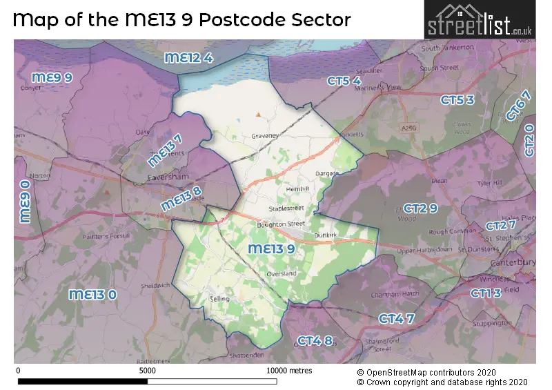
The ME13 9 Postcode shares a border with ME13 0 (Oare, Ospringe, Eastling), ME13 7 (FAVERSHAM), ME13 8 (FAVERSHAM, Ospringe), CT2 9 (Blean, Rough Common, Tyler Hill), CT4 7 (Chartham, CANTERBURY, Chartham Hatch), CT4 8 (Chilham, Old Wives Lees, Molash), CT5 3 (WHITSTABLE, Chestfield, Yorkletts) and CT5 4 (WHITSTABLE, Seasalter).
Map of the ME13 9 Postcode Sector
Explore the ME13 9 postcode sector by using our interactive map.
The sector is within the post town of FAVERSHAM.
ME13 9 is a postcode sector within the ME13 postcode district which is within the ME Medway postcode area.
The Royal Mail delivery office for the ME13 9 postal sector is the Faversham Delivery Office.
The area of the ME13 9 postcode sector is 18.99 square miles which is 49.18 square kilometres or 12,152.03 square acres.
The ME13 9 postcode sector is crossed by the M2 motorway.
The ME13 9 postcode sector is crossed by the A2 Major A road.
Your support helps keep this site running!
If you enjoy using this website, consider buying me a coffee to help cover hosting costs.


| M | E | 1 | 3 | - | 9 | X | X |
| M | E | 1 | 3 | Space | 9 | Letter | Letter |
Official List of Streets
Boughton-under-Blean (34 Streets)
(35 Streets)
Dunkirk (17 Streets)
Graveney (6 Streets)
Dargate (4 Streets)
Hernhill (13 Streets)
Selling (21 Streets)
FAVERSHAM (2 Streets)
Goodnestone (5 Streets)
Sheldwich (2 Streets)
Unofficial Streets or Alternative Spellings
Yorkletts
DARGATE ROADSeasalter
FAVERSHAM ROADChestfield
THANET WAYChartham Hatch
DENSTEAD LANEDenstroude
COURTENAY ROADChilham
NEW CUT ROADSelling
WOODGATE COURTShottenden
STONE STILE ROADGoodnestone
GRAVENEY ROADFAVERSHAM
ABBEY FIELDS LONDON ROAD SALTERS LANEGraveney
WARM HOUSE LANEWeather Forecast for ME13 9
Weather Forecast for Boughton Street
| Time Period | Icon | Description | Temperature | Rain Probability | Wind |
|---|---|---|---|---|---|
| 21:00 to 00:00 | Clear night | 3.0°C (feels like 0.0°C) | 0.00% | WSW 7 mph |
| Time Period | Icon | Description | Temperature | Rain Probability | Wind |
|---|---|---|---|---|---|
| 00:00 to 03:00 | Partly cloudy (night) | 2.0°C (feels like -1.0°C) | 0.00% | SW 7 mph | |
| 03:00 to 06:00 | Cloudy | 2.0°C (feels like -1.0°C) | 6.00% | SW 7 mph | |
| 06:00 to 09:00 | Light rain | 4.0°C (feels like 0.0°C) | 53.00% | SSW 7 mph | |
| 09:00 to 12:00 | Heavy rain | 5.0°C (feels like 1.0°C) | 82.00% | S 11 mph | |
| 12:00 to 15:00 | Light rain | 6.0°C (feels like 3.0°C) | 55.00% | S 9 mph | |
| 15:00 to 18:00 | Overcast | 6.0°C (feels like 3.0°C) | 10.00% | S 9 mph | |
| 18:00 to 21:00 | Cloudy | 5.0°C (feels like 2.0°C) | 8.00% | SSE 7 mph | |
| 21:00 to 00:00 | Cloudy | 4.0°C (feels like 2.0°C) | 8.00% | SSE 4 mph |
| Time Period | Icon | Description | Temperature | Rain Probability | Wind |
|---|---|---|---|---|---|
| 00:00 to 03:00 | Partly cloudy (night) | 3.0°C (feels like 1.0°C) | 2.00% | SSE 4 mph | |
| 03:00 to 06:00 | Partly cloudy (night) | 2.0°C (feels like 0.0°C) | 2.00% | SSE 4 mph | |
| 06:00 to 09:00 | Clear night | 2.0°C (feels like 0.0°C) | 2.00% | SSE 4 mph | |
| 09:00 to 12:00 | Sunny day | 3.0°C (feels like 1.0°C) | 2.00% | SSE 7 mph | |
| 12:00 to 15:00 | Sunny day | 6.0°C (feels like 3.0°C) | 1.00% | SSE 9 mph | |
| 15:00 to 18:00 | Sunny day | 6.0°C (feels like 3.0°C) | 1.00% | SSE 7 mph | |
| 18:00 to 21:00 | Clear night | 2.0°C (feels like 0.0°C) | 1.00% | SSE 4 mph | |
| 21:00 to 00:00 | Clear night | 2.0°C (feels like -1.0°C) | 2.00% | SSE 7 mph |
| Time Period | Icon | Description | Temperature | Rain Probability | Wind |
|---|---|---|---|---|---|
| 00:00 to 03:00 | Clear night | 2.0°C (feels like -2.0°C) | 2.00% | S 9 mph | |
| 03:00 to 06:00 | Partly cloudy (night) | 2.0°C (feels like -2.0°C) | 2.00% | S 9 mph | |
| 06:00 to 09:00 | Partly cloudy (night) | 1.0°C (feels like -2.0°C) | 3.00% | S 9 mph | |
| 09:00 to 12:00 | Partly cloudy (day) | 3.0°C (feels like -1.0°C) | 4.00% | S 9 mph | |
| 12:00 to 15:00 | Sunny day | 6.0°C (feels like 3.0°C) | 7.00% | S 9 mph | |
| 15:00 to 18:00 | Sunny day | 6.0°C (feels like 4.0°C) | 8.00% | SSW 7 mph | |
| 18:00 to 21:00 | Clear night | 2.0°C (feels like 0.0°C) | 4.00% | SSW 4 mph | |
| 21:00 to 00:00 | Clear night | 2.0°C (feels like -1.0°C) | 4.00% | SSW 4 mph |
| Time Period | Icon | Description | Temperature | Rain Probability | Wind |
|---|---|---|---|---|---|
| 00:00 to 03:00 | Clear night | 2.0°C (feels like -1.0°C) | 4.00% | SSW 4 mph | |
| 03:00 to 06:00 | Clear night | 1.0°C (feels like -1.0°C) | 5.00% | SSW 7 mph | |
| 06:00 to 09:00 | Cloudy | 1.0°C (feels like -1.0°C) | 7.00% | SW 4 mph | |
| 09:00 to 12:00 | Cloudy | 3.0°C (feels like 1.0°C) | 6.00% | SSW 7 mph | |
| 12:00 to 15:00 | Cloudy | 6.0°C (feels like 4.0°C) | 5.00% | SSW 9 mph | |
| 15:00 to 18:00 | Cloudy | 6.0°C (feels like 4.0°C) | 6.00% | SSW 9 mph | |
| 18:00 to 21:00 | Cloudy | 4.0°C (feels like 1.0°C) | 5.00% | S 9 mph | |
| 21:00 to 00:00 | Cloudy | 4.0°C (feels like 1.0°C) | 5.00% | S 9 mph |
Schools and Places of Education Within the ME13 9 Postcode Sector
Boughton-under-Blean and Dunkirk Primary School
Voluntary controlled school
School Lane, Faversham, Kent, ME13 9AW
Head: Mr Simon Way
Ofsted Rating: Good
Inspection: 2019-07-11 (2030 days ago)
Website: Visit Boughton-under-Blean and Dunkirk Primary School Website
Phone: 01227751431
Number of Pupils: 203
Graveney Primary School
Academy converter
Seasalter Road, Faversham, Kent, ME13 9DU
Head: Mrs Alison Blackwell
Ofsted Rating: Good
Inspection: 2023-10-04 (484 days ago)
Website: Visit Graveney Primary School Website
Phone: 01795532005
Number of Pupils: 100
Hernhill Church of England Primary School
Voluntary controlled school
Fostall, Faversham, Kent, ME13 9JG
Head: Mrs Sarah Alexander
Ofsted Rating: Outstanding
Inspection: 2017-11-01 (2647 days ago)
Website: Visit Hernhill Church of England Primary School Website
Phone: 01227751322
Number of Pupils: 212
Selling Church of England Primary School
Academy converter
The Street, Faversham, Kent, ME13 9RQ
Head: Mr Richard Paez
Ofsted Rating: Good
Inspection: 2021-11-11 (1176 days ago)
Website: Visit Selling Church of England Primary School Website
Phone: 01227752202
Number of Pupils: 128
House Prices in the ME13 9 Postcode Sector
| Type of Property | 2018 Average | 2018 Sales | 2017 Average | 2017 Sales | 2016 Average | 2016 Sales | 2015 Average | 2015 Sales |
|---|---|---|---|---|---|---|---|---|
| Detached | £510,841 | 22 | £499,817 | 23 | £469,262 | 17 | £380,537 | 27 |
| Semi-Detached | £358,212 | 26 | £315,045 | 22 | £323,884 | 35 | £248,667 | 30 |
| Terraced | £258,989 | 18 | £285,261 | 17 | £260,863 | 15 | £272,803 | 30 |
| Flats | £200,000 | 1 | £215,983 | 3 | £178,200 | 5 | £222,998 | 2 |
Important Postcodes ME13 9 in the Postcode Sector
ME13 9AW is the postcode for Boughton Methodist Primary School, School Lane, and Boughton Methodist Primary School, School Lane, Boughton-under-Blean
ME13 9DU is the postcode for Graveney Cp School, Seasalter Road
ME13 9JG is the postcode for Hernhill C of E Primary School, Forstal, Hernhill, Hernhill Church Of England Primary School, Highstreet Road, and Hernhill C of E Primary School, Forstal
ME13 9RQ is the postcode for Selling C of E Primary School, The Street
| The ME13 9 Sector is within these Local Authorities |
|
|---|---|
| The ME13 9 Sector is within these Counties |
|
| The ME13 9 Sector is within these Water Company Areas |
|