A wide range of spatial data has been analysed to present this overview of the ME10 5 Postcode sector. If you would like anything added, please contact us.
The ME10 5 postcode sector is within the county of Kent.
Did you know? According to the 2021 Census, the ME10 5 postcode sector is home to a bustling 3,679 residents!
Given that each sector allows for 400 unique postcode combinations. Letters C, I, K, M, O and V are not allowed in the last two letters of a postcode. With 73 postcodes already in use, this leaves 327 units available.
The ME10 5 postal code covers the settlement of SITTINGBOURNE.
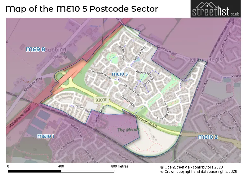
The ME10 5 Postcode shares a border with ME9 8 (Iwade, Borden, Bobbing), ME10 1 (SITTINGBOURNE, Tunstall) and ME10 2 (SITTINGBOURNE, Kemsley, Milton Regis).
Map of the ME10 5 Postcode Sector
Explore the ME10 5 postcode sector by using our interactive map.
The sector is within the post town of SITTINGBOURNE.
ME10 5 is a postcode sector within the ME10 postcode district which is within the ME Medway postcode area.
The Royal Mail delivery office for the ME10 5 postal sector is the Sittingbourne Delivery Office.
The area of the ME10 5 postcode sector is 0.23 square miles which is 0.60 square kilometres or 148.56 square acres.
The ME10 5 postcode sector is crossed by the A249 Major A road.
Your support helps keep this site running!
If you enjoy using this website, consider buying me a coffee to help cover hosting costs.

| M | E | 1 | 0 | - | 5 | X | X |
| M | E | 1 | 0 | Space | 5 | Letter | Letter |
Official List of Streets
SITTINGBOURNE (46 Streets)
(2 Streets)
Unofficial Streets or Alternative Spellings
SITTINGBOURNE
QUINTON ROAD STAPLEHURST ROAD VICARAGE ROAD BOBBING ROUNDABOUT QUINTON LANEBorden
MAIDSTONE ROADWeather Forecast for ME10 5
Weather Forecast for Sittingbourne
| Time Period | Icon | Description | Temperature | Rain Probability | Wind |
|---|---|---|---|---|---|
| 21:00 to 00:00 | Cloudy | 6.0°C (feels like 4.0°C) | 5.00% | SSW 9 mph |
| Time Period | Icon | Description | Temperature | Rain Probability | Wind |
|---|---|---|---|---|---|
| 00:00 to 03:00 | Cloudy | 7.0°C (feels like 5.0°C) | 8.00% | SSW 7 mph | |
| 03:00 to 06:00 | Cloudy | 7.0°C (feels like 5.0°C) | 8.00% | SSW 7 mph | |
| 06:00 to 09:00 | Cloudy | 7.0°C (feels like 5.0°C) | 4.00% | SSW 9 mph | |
| 09:00 to 12:00 | Overcast | 8.0°C (feels like 5.0°C) | 7.00% | SSW 11 mph | |
| 12:00 to 15:00 | Cloudy | 9.0°C (feels like 7.0°C) | 4.00% | SSW 11 mph | |
| 15:00 to 18:00 | Cloudy | 10.0°C (feels like 7.0°C) | 4.00% | SSW 13 mph | |
| 18:00 to 21:00 | Overcast | 9.0°C (feels like 6.0°C) | 16.00% | SSW 13 mph | |
| 21:00 to 00:00 | Light rain | 9.0°C (feels like 7.0°C) | 59.00% | WSW 11 mph |
| Time Period | Icon | Description | Temperature | Rain Probability | Wind |
|---|---|---|---|---|---|
| 00:00 to 03:00 | Clear night | 7.0°C (feels like 5.0°C) | 5.00% | WSW 9 mph | |
| 03:00 to 06:00 | Clear night | 5.0°C (feels like 2.0°C) | 1.00% | WSW 9 mph | |
| 06:00 to 09:00 | Clear night | 4.0°C (feels like 1.0°C) | 0.00% | WSW 7 mph | |
| 09:00 to 12:00 | Partly cloudy (day) | 5.0°C (feels like 2.0°C) | 1.00% | W 7 mph | |
| 12:00 to 15:00 | Partly cloudy (day) | 8.0°C (feels like 6.0°C) | 2.00% | WNW 7 mph | |
| 15:00 to 18:00 | Cloudy | 8.0°C (feels like 7.0°C) | 5.00% | NW 7 mph | |
| 18:00 to 21:00 | Cloudy | 5.0°C (feels like 3.0°C) | 5.00% | NNW 4 mph | |
| 21:00 to 00:00 | Partly cloudy (night) | 4.0°C (feels like 2.0°C) | 2.00% | N 7 mph |
| Time Period | Icon | Description | Temperature | Rain Probability | Wind |
|---|---|---|---|---|---|
| 00:00 to 03:00 | Partly cloudy (night) | 3.0°C (feels like 0.0°C) | 1.00% | N 7 mph | |
| 03:00 to 06:00 | Clear night | 2.0°C (feels like -1.0°C) | 1.00% | NNE 7 mph | |
| 06:00 to 09:00 | Clear night | 2.0°C (feels like -1.0°C) | 1.00% | NNE 7 mph | |
| 09:00 to 12:00 | Sunny day | 4.0°C (feels like 1.0°C) | 1.00% | NE 9 mph | |
| 12:00 to 15:00 | Sunny day | 8.0°C (feels like 5.0°C) | 2.00% | ENE 11 mph | |
| 15:00 to 18:00 | Sunny day | 7.0°C (feels like 4.0°C) | 2.00% | ENE 13 mph | |
| 18:00 to 21:00 | Clear night | 5.0°C (feels like 2.0°C) | 2.00% | NE 11 mph | |
| 21:00 to 00:00 | Clear night | 5.0°C (feels like 1.0°C) | 1.00% | NE 11 mph |
| Time Period | Icon | Description | Temperature | Rain Probability | Wind |
|---|---|---|---|---|---|
| 00:00 to 03:00 | Partly cloudy (night) | 4.0°C (feels like 1.0°C) | 1.00% | NE 11 mph | |
| 03:00 to 06:00 | Partly cloudy (night) | 4.0°C (feels like 0.0°C) | 1.00% | NE 11 mph | |
| 06:00 to 09:00 | Clear night | 4.0°C (feels like 0.0°C) | 3.00% | NE 11 mph | |
| 09:00 to 12:00 | Cloudy | 5.0°C (feels like 1.0°C) | 6.00% | NE 13 mph | |
| 12:00 to 15:00 | Partly cloudy (day) | 6.0°C (feels like 1.0°C) | 4.00% | ENE 13 mph | |
| 15:00 to 18:00 | Cloudy | 5.0°C (feels like 1.0°C) | 6.00% | NE 13 mph | |
| 18:00 to 21:00 | Overcast | 4.0°C (feels like 0.0°C) | 7.00% | NE 11 mph | |
| 21:00 to 00:00 | Overcast | 4.0°C (feels like 0.0°C) | 8.00% | NE 11 mph |
Schools and Places of Education Within the ME10 5 Postcode Sector
Aspire School
Free schools special
Vellum Drive, Sittingbourne, Kent, ME10 5DA
Head: Mr Neil Dipple
Ofsted Rating: Requires improvement
Inspection: 2022-10-12 (845 days ago)
Website: Visit Aspire School Website
Phone: 01795899788
Number of Pupils: 152
House Prices in the ME10 5 Postcode Sector
| Type of Property | 2018 Average | 2018 Sales | 2017 Average | 2017 Sales | 2016 Average | 2016 Sales | 2015 Average | 2015 Sales |
|---|---|---|---|---|---|---|---|---|
| Detached | £375,652 | 15 | £386,220 | 51 | £340,498 | 44 | £307,999 | 27 |
| Semi-Detached | £255,928 | 14 | £287,393 | 24 | £274,338 | 22 | £243,867 | 23 |
| Terraced | £240,173 | 26 | £243,988 | 25 | £221,555 | 36 | £223,176 | 48 |
| Flats | £144,490 | 26 | £151,721 | 36 | £130,569 | 34 | £124,310 | 53 |
Important Postcodes ME10 5 in the Postcode Sector
ME10 5AA is the postcode for The Meads Medical Practice, 29 Quartz Way
ME10 5DA is the postcode for Aspire School, Vellum Drive
| The ME10 5 Sector is within these Local Authorities |
|
|---|---|
| The ME10 5 Sector is within these Counties |
|
| The ME10 5 Sector is within these Water Company Areas |
|