
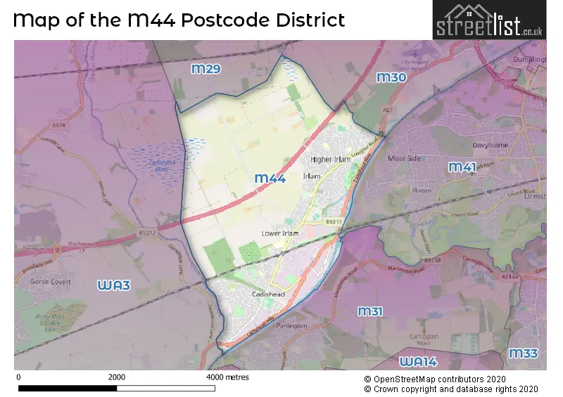
Map of the M44 Postcode District
Explore the postcode district by using our interactive map.
Circles represent recorded crime; the larger the circle, the higher the crime rates.
Your support helps keep this site running!
If you enjoy using this website, consider buying me a coffee to help cover hosting costs.
Where is the M44 District?
To give you an idea where the district is located we have created the following table showing nearby towns.
Nearest Towns to M44
| Town | Distance (miles) | Direction |
|---|---|---|
| Partington | 1.85 | S |
| Urmston | 3.32 | ENE |
| Worsley | 4.58 | NNE |
| Lymm | 4.72 | SSW |
| Eccles | 4.79 | ENE |
| Sale | 4.86 | ESE |
| Tyldesley | 4.92 | NNW |
| Leigh | 4.97 | NW |
| Altrincham | 5.27 | SE |
| Stretford | 5.29 | E |
| Walkden | 5.63 | NNE |
| Atherton | 5.94 | NNW |
| Hale | 6.00 | SE |
| Swinton | 6.07 | NE |
| Salford | 6.29 | ENE |
| Kearsley | 6.98 | NNE |
| Golborne | 7.00 | WNW |
| Farnworth | 7.45 | NNE |
| Warrington | 7.49 | WSW |
The post town for this district is MANCHESTER.
Postcode Information for District M44 (Total Geographical Postcodes: 497)
| Location | Post Town | Sector | Number of Postcodes |
|---|---|---|---|
| Irlam | MANCHESTER | M44 6 | 267 |
| Cadishead | MANCHESTER | M44 5 | 157 |
| Irlam | MANCHESTER | M44 5 | 73 |
Retail and Shopping in M44
Street
Town
Locality
Number of Shops
Central Postcode
View on Google Maps
LIVERPOOL ROAD
MANCHESTER
IRLAM
94
M44 6AJ
View on Google Maps
LIVERPOOL ROAD
MANCHESTER
CADISHEAD
50
M44 5BG
View on Google Maps
FIDDLERS LANE
MANCHESTER
IRLAM
7
M44 6QE
View on Google Maps
| Street | Town | Locality | Number of Shops | Central Postcode | View on Google Maps |
|---|---|---|---|---|---|
| LIVERPOOL ROAD | MANCHESTER | IRLAM | 94 | M44 6AJ | View on Google Maps |
| LIVERPOOL ROAD | MANCHESTER | CADISHEAD | 50 | M44 5BG | View on Google Maps |
| FIDDLERS LANE | MANCHESTER | IRLAM | 7 | M44 6QE | View on Google Maps |
The primary settlement in the M44 postcode district is Cadishead in the county of Greater Manchester. Other significant settlements include Irlam. The M44 postcode belongs to the post town of Manchester in the county of Greater Manchester.
When it comes to local government, postal geography often disregards political borders. However, this district intersects the following councils: the district mostly encompasses the Salford District (B) area with a total of 479 postal codes.
The largest settlements in the M44 postal code are Irlam and Cadishead.
The M44 Postcode shares a border with M31 (Partington, Carrington), M29 (Tyldesley) and M30 (Eccles).


Dentists in the M44 District
| # | Name | Address | Type | Contact |
|---|---|---|---|---|
| 1 | Parkside Dental Care | 610 LIVERPOOL ROAD , IRLAM , MANCHESTER , LANCASHIRE , M44 5AA | GENERAL DENTAL PRACTICE | |
| 2 | Liverpool Road (dental Surgery) | 276 LIVERPOOL ROAD , IRLAM , MANCHESTER , LANCASHIRE , M44 6NA | GENERAL DENTAL PRACTICE |
Doctors in the M44 District
| # | Name | Address | Type | Contact |
|---|---|---|---|---|
| 1 | Dr Hope | , 276 LIVERPOOL ROAD , CADISHEAD , MANCHESTER , GREATER MANCHESTER , M44 5UJ | BRANCH SURGERY | |
| 2 | The Mosslands Medical Practice | , IRLAM , MANCHESTER , LANCASHIRE , M44 5LH | GP PRACTICE | |
| 3 | Chapel Group Medical Centre | , IRLAM , MANCHESTER , LANCASHIRE , M44 6FE | GP PRACTICE | |
| 4 | (irlam) Salford Care Ctrs Medical Practi | , IRLAM , MANCHESTER , LANCASHIRE , M44 6DP | GP PRACTICE |
Chemists in the M44 District
| # | Name | Address | Type | Contact |
|---|---|---|---|---|
| 1 | Well | 512 LIVERPOOL ROAD , IRLAM , MANCHESTER , GREATER MANCHESTER , M44 6AJ | PHARMACY | |
| 2 | Tesco Instore Pharmacy | FAIRHILLS ROAD , IRLAM , MANCHESTER , GREATER MANCHESTER , M44 6BL | PHARMACY | |
| 3 | Higher Irlam Pharmacy | 90 LIVERPOOL ROAD , IRLAM , MANCHESTER , M44 6FN | PHARMACY | |
| 4 | Irlam Pharmacy | MACDONALD HEALTH CENTRE , MACDONALD ROAD , IRLAM , MANCHESTER , M44 5LH | PHARMACY | |
| 5 | Cadishead Pharmacy | 178 LIVERPOOL ROAD , CADISHEAD , MANCHESTER , M44 5DD | PHARMACY | |
| 6 | M44 Pharmacy | GROUND FLOOR , 544 LIVERPOOL ROAD , IRLAM , MANCHESTER , M44 6AJ | PHARMACY |
Opticians in the M44 District
| # | Name | Address | Type | Contact |
|---|---|---|---|---|
| 1 | ALAN MILLER LTD - IRLAM | 596 LIVERPOOL ROAD , IRLAM , MANCHESTER , GREATER MANCHESTER , M44 5AA | OPTICAL SITE |
Schools in the Sector
St Mary's CofE Primary School
Phase: Primary
Address: Buckingham Road , Cadishead , Manchester
Postcode: M44 5HG
Headteacher: Ms Jo McGarry (Headteacher)
Ofsted Rating: Good
Cadishead Primary School
Phase: Primary
Address: Allotment Road , Cadishead , Manchester
Postcode: M44 5JD
Headteacher: Mrs Joanne Thomas (Headteacher)
Ofsted Rating: Special Measures
St Teresa's RC Primary School
Phase: Primary
Address: 5 Macdonald Road , Irlam , Manchester
Postcode: M44 5LH
Headteacher: Mrs Sandra Burgess (Headteacher)
Ofsted Rating: Good
Irlam and Cadishead College
Phase: Secondary
Address: Station Road , Irlam , Manchester
Postcode: M44 5ZR
Headteacher: Mrs M Nightingale (Principal)
Ofsted Rating: Special Measures
Irlam and Cadishead Academy
Phase: Secondary
Address: Station Road , Irlam , Manchester
Postcode: M44 5ZR
Headteacher: Mr Chris Leader ()
Ofsted Rating: Requires improvement
Irlam Endowed Primary School
Phase: Primary
Address: Chapel Road , Irlam , Manchester
Postcode: M44 6EE
Headteacher: Mr Ben Lynch (Headteacher)
Ofsted Rating: Good
Moorfield Community Primary School
Phase: Primary
Address: Cutnook Lane , Irlam , Salford
Postcode: M44 6GX
Headteacher: Mr David Nightingale (Headteacher)
Ofsted Rating: Requires improvement
St Joseph the Worker RC Primary School
Phase: Primary
Address: Cutnook Lane , Irlam , Salford
Postcode: M44 6GX
Headteacher: Mrs Evelyn Clayton (Headteacher)
Ofsted Rating: Good
Irlam Primary School
Phase: Primary
Address: Liverpool Road , Irlam , Manchester
Postcode: M44 6NA
Headteacher: Mrs Elaine Darwin (Headteacher)
Ofsted Rating: Good
Fiddlers Lane Community Primary School
Phase: Primary
Address: Fiddlers Lane , Irlam , Salford
Postcode: M44 6QE
Headteacher: Mr Damian Harris (Headteacher)
Ofsted Rating: Requires improvement
Stations in the Sector
Irlam
CRS Code: IRL
Operator: NT
Line: Liverpool to Manchester (South) lines
Company: Northern
Accessable Motorway Junctions
M60 J12
Average Driving Time from within the district: 5.95
Average Driving Distance: 3.34
Number of Postcodes that can access the Motorway Junction: 176
M6 J21
Average Driving Time from within the district: 6.13
Average Driving Distance: 3.98
Number of Postcodes that can access the Motorway Junction: 172
M602 J1
Average Driving Time from within the district: 6.27
Average Driving Distance: 3.54
Number of Postcodes that can access the Motorway Junction: 252
M60 J11
Average Driving Time from within the district: 6.33
Average Driving Distance: 3.63
Number of Postcodes that can access the Motorway Junction: 431
M62 J12
Average Driving Time from within the district: 6.35
Average Driving Distance: 3.65
Number of Postcodes that can access the Motorway Junction: 296
M60 J10
Average Driving Time from within the district: 7.52
Average Driving Distance: 4.67
Number of Postcodes that can access the Motorway Junction: 444
M60 J9
Average Driving Time from within the district: 7.62
Average Driving Distance: 5.27
Number of Postcodes that can access the Motorway Junction: 43
M62 J10
Average Driving Time from within the district: 8.59
Average Driving Distance: 6.81
Number of Postcodes that can access the Motorway Junction: 45
M6 J21A
Average Driving Time from within the district: 8.62
Average Driving Distance: 6.83
Number of Postcodes that can access the Motorway Junction: 55
M60 J8
Average Driving Time from within the district: 10.37
Average Driving Distance: 7.54
Number of Postcodes that can access the Motorway Junction: 172
M56 J8
Average Driving Time from within the district: 11.78
Average Driving Distance: 7.51
Number of Postcodes that can access the Motorway Junction: 32
M62 J11
Average Driving Time from within the district: 12.83
Average Driving Distance: 9.27
Number of Postcodes that can access the Motorway Junction: 282
Weather Forecast for Irlam
| Time Period | Icon | Description | Temperature | Rain Probability | Wind |
|---|---|---|---|---|---|
| 03:00 to 06:00 | Cloudy | 6.0°C (feels like 4.0°C) | 8.00% | S 7 mph | |
| 06:00 to 09:00 | Partly cloudy (night) | 5.0°C (feels like 2.0°C) | 1.00% | S 7 mph | |
| 09:00 to 12:00 | Cloudy | 5.0°C (feels like 2.0°C) | 4.00% | S 7 mph | |
| 12:00 to 15:00 | Cloudy | 8.0°C (feels like 5.0°C) | 5.00% | S 9 mph | |
| 15:00 to 18:00 | Cloudy | 9.0°C (feels like 7.0°C) | 5.00% | S 9 mph | |
| 18:00 to 21:00 | Cloudy | 8.0°C (feels like 5.0°C) | 5.00% | S 9 mph | |
| 21:00 to 00:00 | Cloudy | 7.0°C (feels like 4.0°C) | 4.00% | S 11 mph |
| Time Period | Icon | Description | Temperature | Rain Probability | Wind |
|---|---|---|---|---|---|
| 00:00 to 03:00 | Cloudy | 7.0°C (feels like 4.0°C) | 4.00% | S 11 mph | |
| 03:00 to 06:00 | Cloudy | 7.0°C (feels like 4.0°C) | 6.00% | S 11 mph | |
| 06:00 to 09:00 | Cloudy | 8.0°C (feels like 5.0°C) | 6.00% | S 13 mph | |
| 09:00 to 12:00 | Cloudy | 9.0°C (feels like 5.0°C) | 13.00% | S 13 mph | |
| 12:00 to 15:00 | Light rain | 9.0°C (feels like 7.0°C) | 54.00% | S 13 mph | |
| 15:00 to 18:00 | Light rain shower (day) | 10.0°C (feels like 7.0°C) | 46.00% | SW 11 mph | |
| 18:00 to 21:00 | Clear night | 8.0°C (feels like 6.0°C) | 9.00% | SW 9 mph | |
| 21:00 to 00:00 | Clear night | 7.0°C (feels like 4.0°C) | 7.00% | WSW 9 mph |
| Time Period | Icon | Description | Temperature | Rain Probability | Wind |
|---|---|---|---|---|---|
| 00:00 to 03:00 | Clear night | 6.0°C (feels like 3.0°C) | 3.00% | WSW 11 mph | |
| 03:00 to 06:00 | Partly cloudy (night) | 5.0°C (feels like 2.0°C) | 2.00% | W 9 mph | |
| 06:00 to 09:00 | Partly cloudy (night) | 5.0°C (feels like 2.0°C) | 1.00% | W 9 mph | |
| 09:00 to 12:00 | Cloudy | 5.0°C (feels like 3.0°C) | 4.00% | WSW 7 mph | |
| 12:00 to 15:00 | Cloudy | 7.0°C (feels like 5.0°C) | 5.00% | W 9 mph | |
| 15:00 to 18:00 | Partly cloudy (day) | 8.0°C (feels like 6.0°C) | 2.00% | WNW 9 mph | |
| 18:00 to 21:00 | Clear night | 5.0°C (feels like 3.0°C) | 1.00% | W 4 mph | |
| 21:00 to 00:00 | Clear night | 4.0°C (feels like 2.0°C) | 2.00% | WSW 2 mph |
| Time Period | Icon | Description | Temperature | Rain Probability | Wind |
|---|---|---|---|---|---|
| 00:00 to 03:00 | Clear night | 2.0°C (feels like 1.0°C) | 1.00% | SSE 2 mph | |
| 03:00 to 06:00 | Clear night | 1.0°C (feels like 0.0°C) | 2.00% | SE 2 mph | |
| 06:00 to 09:00 | Clear night | 1.0°C (feels like -1.0°C) | 2.00% | ESE 2 mph | |
| 09:00 to 12:00 | Sunny day | 2.0°C (feels like 0.0°C) | 2.00% | ESE 4 mph | |
| 12:00 to 15:00 | Sunny day | 6.0°C (feels like 4.0°C) | 1.00% | SE 4 mph | |
| 15:00 to 18:00 | Sunny day | 7.0°C (feels like 6.0°C) | 1.00% | ESE 4 mph | |
| 18:00 to 21:00 | Clear night | 5.0°C (feels like 3.0°C) | 1.00% | E 4 mph | |
| 21:00 to 00:00 | Clear night | 3.0°C (feels like 1.0°C) | 1.00% | E 7 mph |
| Postal Sector | Delivery Office |
|---|---|
| M44 5 | Irlam Delivery Office |
| M44 6 | Irlam Delivery Office |
| M | 4 | 4 | - | X | X | X |
| M | 4 | 4 | Space | Numeric | Letter | Letter |
Street List for the M44 District
Current Monthly Rental Prices
| # Bedrooms | Min Price | Max Price | Avg Price |
|---|---|---|---|
| 1 | £650 | £650 | £650 |
| 2 | £900 | £995 | £948 |
| 3 | £1,100 | £1,200 | £1,150 |
| 4 | £1,500 | £1,500 | £1,500 |
Current House Prices
| # Bedrooms | Min Price | Max Price | Avg Price |
|---|---|---|---|
| 1 | £85,000 | £85,000 | £85,000 |
| 2 | £80,000 | £400,000 | £195,285 |
| 3 | £150,000 | £399,995 | £252,380 |
| 4 | £265,000 | £510,000 | £366,388 |
Estate Agents
| Logo | Name | Brand Name | Address | Contact Number |
|---|---|---|---|---|
 | Irlam | Chris Wilkinson | 8 Moorfield Parade, Irlam, M44 6FY | 0161 524 8525 |
 | Cadishead | Oliver James | 4 Liverpool Road, Cadishead, Manchester, M44 5AF | 0161 524 8901 |
 | Irlam | Irlam Estates | 200 Liverpool Road, Irlam, Manchester, M44 6FE | 0161 524 4466 |
 | Walkden | Bridgfords | 2 Bridgewater Road, Walkden, Worsley, M28 3JE | 0161 524 9322 |
 | Eccles | Hills | Sentinel House Albert Street Eccles Manchester M30 0SS | 0161 707 4900 |
Yearly House Price Averages for the District
| Type of Property | 2018 Average | 2018 Sales | 2017 Average | 2017 Sales | 2016 Average | 2016 Sales | 2015 Average | 2015 Sales |
|---|---|---|---|---|---|---|---|---|
| Detached | £233,574 | 47 | £216,327 | 38 | £215,822 | 60 | £192,662 | 37 |
| Semi-Detached | £160,437 | 153 | £146,859 | 186 | £143,231 | 147 | £123,912 | 104 |
| Terraced | £126,737 | 106 | £123,117 | 81 | £111,823 | 118 | £103,530 | 91 |
| Flats | £84,702 | 25 | £86,125 | 24 | £83,286 | 21 | £77,188 | 24 |