A wide range of spatial data has been analysed to present this overview of the M29 7 Postcode sector. If you would like anything added, please contact us.
The M29 7 postcode sector is within the county of Greater Manchester.
Did you know? According to the 2021 Census, the M29 7 postcode sector is home to a bustling 13,657 residents!
Given that each sector allows for 400 unique postcode combinations. Letters C, I, K, M, O and V are not allowed in the last two letters of a postcode. With 289 postcodes already in use, this leaves 111 units available.
The M29 7 postal code covers the settlement of Tyldesley.
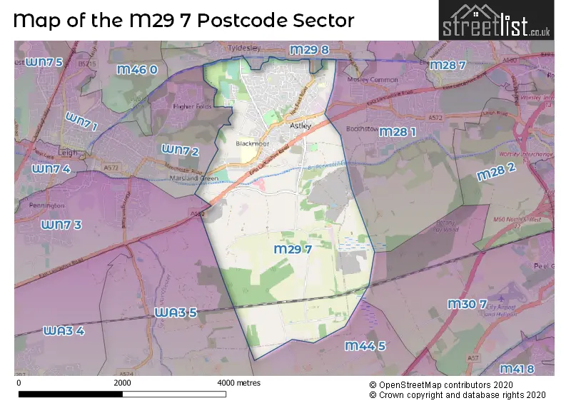
The M29 7 Postcode shares a border with WA3 5 (Culcheth, Glazebury, Glazebrook), WN7 2 (LEIGH), WN7 3 (LEIGH, Moss Industrial Estate, Hope Carr), M29 8 (Tyldesley), M28 1 (Worsley), M30 7 (Eccles) and M44 5 (Cadishead, Irlam).
Map of the M29 7 Postcode Sector
Explore the M29 7 postcode sector by using our interactive map.
The sector is within the post town of MANCHESTER.
M29 7 is a postcode sector within the M29 postcode district which is within the M Manchester postcode area.
The Royal Mail delivery office for the M29 7 postal sector is the Tyldesley Delivery Office.
The area of the M29 7 postcode sector is 5.42 square miles which is 14.04 square kilometres or 3,468.46 square acres.
Waterways within the M29 7 postcode sector include the Bridgewater Canal.
Your support helps keep this site running!
If you enjoy using this website, consider buying me a coffee to help cover hosting costs.

| M | 2 | 9 | - | 7 | X | X |
| M | 2 | 9 | Space | 7 | Letter | Letter |
Official List of Streets
Tyldesley (207 Streets)
Unofficial Streets or Alternative Spellings
Tyldesley
ALLAN STREET GARRETT MEADOW HOUGH LANE KING WILLIAM STREET LAMBERT MEADOW LEMON STREET LUNE STREET WAREING STREET WAYFARERS DRIVE ASTLEY SERVICE STATION BRIMELOW BUILDINGS GIN PIT HAMILTON ROAD HEN FOLD ROAD JOANS WAY LEIGH GUIDED BUSWAY LIGHTWOOD LINGARDS FOOTBRIDGE MORLEYS BRIDGE MUIRFIED DRIVE NORTH RIDGE CLOSE SOUTH GARDENS TOWN LANE WESTACRE CLOSE WHITEHEAD HALL BRIDGE WHITEHEAD HALL MEADOWS WALK WOODLAND ROADGlazebury
EAST LANCASHIRE ROADWorsley
ASTLEY PARK WAY NORTON ROADIrlam
ASTLEY ROADWeather Forecast for M29 7
Weather Forecast for Tyldesley
| Time Period | Icon | Description | Temperature | Rain Probability | Wind |
|---|---|---|---|---|---|
| 21:00 to 00:00 | Cloudy | 5.0°C (feels like 2.0°C) | 8.00% | SE 9 mph |
| Time Period | Icon | Description | Temperature | Rain Probability | Wind |
|---|---|---|---|---|---|
| 00:00 to 03:00 | Overcast | 5.0°C (feels like 2.0°C) | 10.00% | SSE 11 mph | |
| 03:00 to 06:00 | Overcast | 5.0°C (feels like 1.0°C) | 9.00% | SSE 11 mph | |
| 06:00 to 09:00 | Overcast | 4.0°C (feels like 1.0°C) | 10.00% | SSE 11 mph | |
| 09:00 to 12:00 | Cloudy | 4.0°C (feels like 1.0°C) | 9.00% | SSE 9 mph | |
| 12:00 to 15:00 | Overcast | 6.0°C (feels like 3.0°C) | 9.00% | SSE 9 mph | |
| 15:00 to 18:00 | Overcast | 7.0°C (feels like 5.0°C) | 14.00% | SSE 4 mph | |
| 18:00 to 21:00 | Overcast | 6.0°C (feels like 4.0°C) | 13.00% | SSE 4 mph | |
| 21:00 to 00:00 | Overcast | 6.0°C (feels like 4.0°C) | 9.00% | S 4 mph |
| Time Period | Icon | Description | Temperature | Rain Probability | Wind |
|---|---|---|---|---|---|
| 00:00 to 03:00 | Overcast | 5.0°C (feels like 4.0°C) | 8.00% | S 4 mph | |
| 03:00 to 06:00 | Cloudy | 4.0°C (feels like 2.0°C) | 5.00% | S 4 mph | |
| 06:00 to 09:00 | Cloudy | 3.0°C (feels like 1.0°C) | 4.00% | SSE 7 mph | |
| 09:00 to 12:00 | Cloudy | 4.0°C (feels like 1.0°C) | 4.00% | SSE 7 mph | |
| 12:00 to 15:00 | Cloudy | 7.0°C (feels like 4.0°C) | 4.00% | S 9 mph | |
| 15:00 to 18:00 | Cloudy | 9.0°C (feels like 7.0°C) | 4.00% | S 9 mph | |
| 18:00 to 21:00 | Cloudy | 7.0°C (feels like 5.0°C) | 5.00% | S 9 mph | |
| 21:00 to 00:00 | Cloudy | 6.0°C (feels like 3.0°C) | 5.00% | S 11 mph |
| Time Period | Icon | Description | Temperature | Rain Probability | Wind |
|---|---|---|---|---|---|
| 00:00 to 03:00 | Cloudy | 6.0°C (feels like 3.0°C) | 5.00% | S 11 mph | |
| 03:00 to 06:00 | Overcast | 7.0°C (feels like 4.0°C) | 9.00% | S 11 mph | |
| 06:00 to 09:00 | Cloudy | 7.0°C (feels like 4.0°C) | 11.00% | S 11 mph | |
| 09:00 to 12:00 | Cloudy | 8.0°C (feels like 5.0°C) | 20.00% | S 11 mph | |
| 12:00 to 15:00 | Light rain | 9.0°C (feels like 6.0°C) | 54.00% | SSW 11 mph | |
| 15:00 to 18:00 | Light rain | 9.0°C (feels like 7.0°C) | 51.00% | SW 11 mph | |
| 18:00 to 21:00 | Clear night | 8.0°C (feels like 5.0°C) | 12.00% | SW 9 mph | |
| 21:00 to 00:00 | Clear night | 7.0°C (feels like 4.0°C) | 7.00% | WSW 9 mph |
| Time Period | Icon | Description | Temperature | Rain Probability | Wind |
|---|---|---|---|---|---|
| 00:00 to 03:00 | Clear night | 6.0°C (feels like 3.0°C) | 3.00% | W 9 mph | |
| 03:00 to 06:00 | Clear night | 5.0°C (feels like 2.0°C) | 2.00% | W 9 mph | |
| 06:00 to 09:00 | Clear night | 4.0°C (feels like 1.0°C) | 2.00% | WSW 7 mph | |
| 09:00 to 12:00 | Cloudy | 4.0°C (feels like 2.0°C) | 5.00% | SW 4 mph | |
| 12:00 to 15:00 | Cloudy | 7.0°C (feels like 5.0°C) | 4.00% | WSW 4 mph | |
| 15:00 to 18:00 | Sunny day | 8.0°C (feels like 6.0°C) | 1.00% | WSW 7 mph | |
| 18:00 to 21:00 | Clear night | 5.0°C (feels like 3.0°C) | 1.00% | SW 4 mph | |
| 21:00 to 00:00 | Clear night | 3.0°C (feels like 2.0°C) | 1.00% | SSE 4 mph |
Schools and Places of Education Within the M29 7 Postcode Sector
Garrett Hall Primary School
Community school
Garrett Lane, Manchester, , M29 7EY
Head: Mrs Tracy Beaty
Ofsted Rating: Outstanding
Inspection: 2013-02-20 (4364 days ago)
Website: Visit Garrett Hall Primary School Website
Phone: 01942883340
Number of Pupils: 473
St Ambrose Barlow Catholic Primary School
Voluntary aided school
Manchester Road, Manchester, , M29 7DY
Head: Mr G Doherty
Ofsted Rating: Good
Inspection: 2023-09-28 (492 days ago)
Website: Visit St Ambrose Barlow Catholic Primary School Website
Phone: 01942883912
Number of Pupils: 210
St Mary's Catholic High School
Voluntary aided school
Manchester Road, Manchester, , M29 7EE
Head: Denise Brahms
Ofsted Rating: Good
Inspection: 2019-04-03 (2131 days ago)
Website: Visit St Mary's Catholic High School Website
Phone: 01942884144
Number of Pupils: 1561
St Stephen's CofE Primary School
Voluntary aided school
Manchester Road, Manchester, , M29 7BT
Head: Jill Southern
Ofsted Rating: Good
Inspection: 2021-12-02 (1157 days ago)
Website: Visit St Stephen's CofE Primary School Website
Phone: 01942882412
Number of Pupils: 210
Tyldesley Primary School
Academy converter
Ennerdale Road, Manchester, Greater Manchester, M29 7PY
Head: Mrs Janet Shorrock
Ofsted Rating: Good
Inspection: 2020-02-05 (1823 days ago)
Website: Visit Tyldesley Primary School Website
Phone: 01942882870
Number of Pupils: 448
House Prices in the M29 7 Postcode Sector
| Type of Property | 2018 Average | 2018 Sales | 2017 Average | 2017 Sales | 2016 Average | 2016 Sales | 2015 Average | 2015 Sales |
|---|---|---|---|---|---|---|---|---|
| Detached | £263,384 | 77 | £253,213 | 86 | £240,010 | 95 | £236,012 | 92 |
| Semi-Detached | £167,423 | 116 | £153,778 | 138 | £152,291 | 112 | £137,871 | 100 |
| Terraced | £141,294 | 39 | £132,771 | 48 | £143,946 | 29 | £138,876 | 27 |
| Flats | £160,274 | 18 | £86,286 | 10 | £66,812 | 8 | £60,143 | 7 |
Important Postcodes M29 7 in the Postcode Sector
M29 7BT is the postcode for Astley St. Stephens C of E Primary School, Manchester Road, and Astley St. Stephens C of E Primary School, Manchester Road, Astley, Tyldesley
M29 7DY is the postcode for St. Ambrose RC Primary School, Manchester Road, and St. Ambrose RC Primary School, Manchester Road, Astley, Tyldesley
M29 7EE is the postcode for COMMUNICATIONS BLOCK, St. Marys RC High School, Manchester Road, SCIENCE BLOCK, St. Marys RC High School, Manchester Road, TECHNOLOGY BLOCK, St. Marys RC High School, Manchester Road, MAIN BUILDING, St. Marys RC High School, Manchester Road, St. Marys RC High School, Manchester Road, SIXTH FORM BLOCK, St. Marys RC High School, Manchester Road, EXCELLENCE CENTRE, St. Marys RC High School, Manchester Road, MUSIC BLOCK 3, St. Marys RC High School, Manchester Road, SPORTS HALL, St. Marys RC High School, Manchester Road, and I.T. BLOCK 4, St. Marys RC High School, Manchester Road
M29 7EY is the postcode for DINING/NURSERY BLOCKS, Garrett Hall School, Garrett Lane, MAIN BLOCK, Garrett Hall School, Garrett Lane, and Garrett Hall School, Garrett Lane
M29 7PY is the postcode for MAIN BUILDING, Tyldesley Primary School, Ennerdale Road, NURSERY, Tyldesley Primary School, Ennerdale Road, and Tyldesley Primary School, Ennerdale Road
| The M29 7 Sector is within these Local Authorities |
|
|---|---|
| The M29 7 Sector is within these Counties |
|
| The M29 7 Sector is within these Water Company Areas |
|