
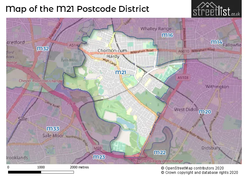
Map of the M21 Postcode District
Explore the postcode district by using our interactive map.
Circles represent recorded crime; the larger the circle, the higher the crime rates.
Your support helps keep this site running!
If you enjoy using this website, consider buying me a coffee to help cover hosting costs.
Where is the M21 District?
To give you an idea where the district is located we have created the following table showing nearby towns.
Nearest Towns to M21
| Town | Distance (miles) | Direction |
|---|---|---|
| Stretford | 1.68 | WNW |
| Sale | 2.18 | WSW |
| Gatley | 3.23 | SSE |
| Manchester | 3.31 | NNE |
| Salford | 3.37 | NNW |
| Urmston | 3.90 | WNW |
| Cheadle | 4.15 | SE |
| Eccles | 4.34 | NW |
| Altrincham | 4.56 | SW |
| Hale | 4.67 | SW |
| Stockport | 5.01 | ESE |
| Cheadle Hulme | 5.30 | SE |
| Irlam | 5.90 | WNW |
| Swinton | 6.10 | NNW |
| Droylsden | 6.18 | ENE |
| Partington | 6.51 | W |
| Bramhall | 6.68 | SE |
| Denton | 6.72 | ENE |
| Worsley | 6.81 | NW |
| Failsworth | 6.85 | NE |
The post town for this district is MANCHESTER.
Postcode Information for District M21 (Total Geographical Postcodes: 990)
| Location | Post Town | Sector | Number of Postcodes |
|---|---|---|---|
| MANCHESTER | MANCHESTER | M21 9 | 273 |
| MANCHESTER | MANCHESTER | M21 7 | 202 |
| MANCHESTER | MANCHESTER | M21 0 | 181 |
| MANCHESTER | MANCHESTER | M21 8 | 156 |
| Chorlton Cum Hardy | MANCHESTER | M21 9 | 92 |
| Chorlton Cum Hardy | MANCHESTER | M21 0 | 47 |
| Chorlton Cum Hardy | MANCHESTER | M21 7 | 33 |
| Chorlton Cum Hardy | MANCHESTER | M21 8 | 6 |
Retail and Shopping in M21
Street
Town
Locality
Number of Shops
Central Postcode
View on Google Maps
BARLOW MOOR ROAD
MANCHESTER
119
M21 8AZ
View on Google Maps
WILBRAHAM ROAD
MANCHESTER
90
M21 0AS
View on Google Maps
BEECH ROAD
MANCHESTER
34
M21 9EQ
View on Google Maps
MANCHESTER ROAD
MANCHESTER
28
M21 9GA
View on Google Maps
CHORLTON PLACE
MANCHESTER
18
M21 9AQ
View on Google Maps
MERSEY BANK AVENUE
MANCHESTER
11
M21 7NN
View on Google Maps
MAULDETH ROAD WEST
MANCHESTER
9
M21 7SH
View on Google Maps
EGERTON ROAD SOUTH
MANCHESTER
6
M21 0XN
View on Google Maps
| Street | Town | Locality | Number of Shops | Central Postcode | View on Google Maps |
|---|---|---|---|---|---|
| BARLOW MOOR ROAD | MANCHESTER | 119 | M21 8AZ | View on Google Maps | |
| WILBRAHAM ROAD | MANCHESTER | 90 | M21 0AS | View on Google Maps | |
| BEECH ROAD | MANCHESTER | 34 | M21 9EQ | View on Google Maps | |
| MANCHESTER ROAD | MANCHESTER | 28 | M21 9GA | View on Google Maps | |
| CHORLTON PLACE | MANCHESTER | 18 | M21 9AQ | View on Google Maps | |
| MERSEY BANK AVENUE | MANCHESTER | 11 | M21 7NN | View on Google Maps | |
| MAULDETH ROAD WEST | MANCHESTER | 9 | M21 7SH | View on Google Maps | |
| EGERTON ROAD SOUTH | MANCHESTER | 6 | M21 0XN | View on Google Maps |
The primary settlement in the M21 postcode district is Chorlton Cum Hardy, located in the county of Greater Manchester in England. The most significant post town in this postcode district is Manchester.
When it comes to local government, postal geography often disregards political borders. However, this district intersects the following councils: the district mostly encompasses the Manchester District (B) area with a total of 722 postal codes.
The largest settlements in the M21 postal code are MANCHESTER and Chorlton Cum Hardy.
The M21 Postcode shares a border with M23 (MANCHESTER, Roundthorn Industrial Estate, Wythenshawe), M16 (MANCHESTER, Old Trafford, Whalley Range), M20 (MANCHESTER, Withington, Didsbury), M32 (Stretford), M14 (MANCHESTER, Fallowfield) and M33 (SALE).


Dentists in the M21 District
| # | Name | Address | Type | Contact |
|---|---|---|---|---|
| 1 | Dental Surgery | 555 BARLOW MOOR ROAD , MANCHESTER , LANCASHIRE , M21 8AN | GENERAL DENTAL PRACTICE | |
| 2 | Dental Surgery | 7 SANDY LANE , MANCHESTER , LANCASHIRE , M21 8TL | GENERAL DENTAL PRACTICE | |
| 3 | Wood And Woolfstein | DENTAL SURGERY , 452 BARLOW MOOR ROAD , MANCHESTER , LANCASHIRE , M21 0BQ | GENERAL DENTAL PRACTICE | |
| 4 | Dental Surgery | 563 BARLOW MOOR ROAD , MANCHESTER , LANCASHIRE , M21 8AE | GENERAL DENTAL PRACTICE | |
| 5 | Dental Surgery | 563 BARLOW MOOR ROAD , MANCHESTER , M21 8AE | GENERAL DENTAL PRACTICE |
Doctors in the M21 District
| # | Name | Address | Type | Contact |
|---|---|---|---|---|
| 1 | David Medical Centre | , CHORLTON CUM HARDY , MANCHESTER , LANCASHIRE , M21 8HA | GP PRACTICE | |
| 2 | Chorlton Family Practice | , 1 NICOLAS ROAD , CHORLTON CUM HARDY , MANCHESTER , GREATER MANCHESTER , M21 9NJ | GP PRACTICE | |
| 3 | Wilbraham Surgery | , CHORLTON CUM HARDY , MANCHESTER , LANCASHIRE , M21 0UF | GP PRACTICE | |
| 4 | Merseybank Surgery | , MANCHESTER , M21 7NN | BRANCH SURGERY | |
| 5 | Corkland Road Medical Practice | , MANCHESTER , M21 8UP | BRANCH SURGERY |
Chemists in the M21 District
| # | Name | Address | Type | Contact |
|---|---|---|---|---|
| 1 | Wilbraham Pharmacy | 521 WILBRAHAM ROAD , CHORLTON CUM HARDY , MANCHESTER , LANCASHIRE , M21 0UF | PHARMACY | |
| 2 | Beech Road Pharmacy | 101 BEECH ROAD , CHORLTON , MANCHESTER , M21 9EQ | PHARMACY | |
| 3 | Merseybank Pharmacy | 30 MERSEY BANK AVENUE , MANCHESTER , GREATER MANCHESTER , M21 7NN | PHARMACY | |
| 4 | Everest Pharmacy Chorlton Village | 420 WILBRAHAM ROAD , CHORLTON-CUM-HARDY , MANCHESTER , M21 0AS | PHARMACY | |
| 5 | Everest Pharmacy Barlow Moor Road | 280 BARLOW MOOR ROAD , CHORLTON-CUM-HARDY , MANCHESTER , M21 8HA | PHARMACY |
Opticians in the M21 District
| # | Name | Address | Type | Contact |
|---|---|---|---|---|
| 1 | DIRECT VISION [CHORLTON] | 444 WILBRAHAM ROAD , MANCHESTER , GREATER MANCHESTER , M21 0AG | OPTICAL SITE | |
| 2 | VISIONCARE OPTICIANS | 420 BARLOW MOOR ROAD , CHORLTON , MANCHESTER , GREATER MANCHESTER , M21 8AD | OPTICAL SITE | |
| 3 | CADMANS VISIONCARE | 420 BARLOW MOOR ROAD , MANCHESTER , M21 8AD | OPTICAL SITE | |
| 4 | UNA MARTIN OPTOMETRISTS LTD | 12 FAIRHAVEN AVENUE , CHORLTON , MANCHESTER , GREATER MANCHESTER , M21 8TW | OPTICAL SITE | |
| 5 | FRAMED CHORLTON LTD - BEECH ROAD | 113 BEECH ROAD , MANCHESTER , M21 9EQ | OPTICAL SITE | |
| 6 | VALLI CHORLTON (CHORLTON-CUM-HARDY) | 448 BARLOW MOOR ROAD , MANCHESTER , M21 0BQ | OPTICAL SITE | |
| 7 | RAHIL SAGGAR (CHORLTON) LTD T/A BOOTS OPTICIANS | 426 BARLOW MOOR ROAD , MANCHESTER , M21 8AD | OPTICAL SITE |
Schools in the Sector
Chorlton Park Primary School
Phase: Primary
Address: Barlow Moor Road , Chorlton-Cum-Hardy , Manchester
Postcode: M21 7HH
Headteacher: Mr David Watson (Headteacher)
Ofsted Rating: Outstanding
Barlow Hall Primary School
Phase: Primary
Address: Darley Avenue , Chorlton-Cum-Hardy , Manchester
Postcode: M21 7JG
Headteacher: Ms Jayne Kennedy (Headteacher)
Ofsted Rating: Good
Barlow Hall Primary School
Phase: Primary
Address: Darley Avenue , Chorlton-Cum-Hardy , Manchester
Postcode: M21 7JG
Headteacher: Ms Jayne Kennedy (Headteacher)
Ofsted Rating: Good
Manchester Secondary PRU
Phase: Not applicable
Address: Mersey Valley Campus , Barlow Hall Road , Chorlton
Postcode: M21 7JJ
Headteacher: Mr Colin Harvey-Rigby (Headteacher)
Ofsted Rating: Good
St Ambrose RC Primary School
Phase: Primary
Address: Princess Road , Chorlton-Cum-Hardy , Manchester
Postcode: M21 7QA
Headteacher: Mrs Michelle Waterworth (Headteacher)
Ofsted Rating: Good
Chorlton High School
Phase: Secondary
Address: Nell Lane , Chorlton-Cum-Hardy , Manchester
Postcode: M21 7SL
Headteacher: Ms Zoe Morris (Headteacher)
Ofsted Rating: Good
Loreto High School Chorlton
Phase: Secondary
Address: Nell Lane , Chorlton-Cum-Hardy , Manchester
Postcode: M21 7SW
Headteacher: Mrs Catherine Hughes (Acting Headteacher)
Ofsted Rating: Good
CHS South
Phase: Secondary
Address: 451 Mauldeth Road West , Chorlton , Manchester
Postcode: M21 7SX
Headteacher: Mr Andy Park ()
Ofsted Rating: Good
Brookburn Community School
Phase: Primary
Address: Brookburn Road , Chorlton-Cum-Hardy , Manchester
Postcode: M21 8EH
Headteacher: Ms Schelene Ferris (Headteacher)
Ofsted Rating: Outstanding
Chorlton CofE Primary School
Phase: Primary
Address: Vicars Road , Chorlton-Cum-Hardy , Manchester
Postcode: M21 9JA
Headteacher: Mr Philip Trohear (Headteacher)
Ofsted Rating: Outstanding
Oswald Road Primary School
Phase: Primary
Address: Oswald Road , Chorlton-Cum-Hardy , Manchester
Postcode: M21 9PL
Headteacher: Mrs Deborah Howard (Headteacher)
Ofsted Rating: Good
St John's RC Primary School
Phase: Primary
Address: Chepstow Road , Chorlton-Cum-Hardy , Manchester
Postcode: M21 9SN
Headteacher: Mrs B O'Donoghue (Headteacher)
Ofsted Rating: Good
Stations in the Sector
No stations found in this postcode district.
Accessable Motorway Junctions
M60 J5
Average Driving Time from within the district: 4.47
Average Driving Distance: 1.99
Number of Postcodes that can access the Motorway Junction: 714
M60 J4
Average Driving Time from within the district: 4.59
Average Driving Distance: 3.00
Number of Postcodes that can access the Motorway Junction: 93
M60 J7
Average Driving Time from within the district: 5.13
Average Driving Distance: 2.30
Number of Postcodes that can access the Motorway Junction: 656
M56 J3A
Average Driving Time from within the district: 5.48
Average Driving Distance: 2.80
Number of Postcodes that can access the Motorway Junction: 376
M60 J8
Average Driving Time from within the district: 5.54
Average Driving Distance: 2.91
Number of Postcodes that can access the Motorway Junction: 495
M60 J6
Average Driving Time from within the district: 5.93
Average Driving Distance: 3.28
Number of Postcodes that can access the Motorway Junction: 725
M56 J2
Average Driving Time from within the district: 6.02
Average Driving Distance: 3.10
Number of Postcodes that can access the Motorway Junction: 172
M60 J9
Average Driving Time from within the district: 6.25
Average Driving Distance: 2.86
Number of Postcodes that can access the Motorway Junction: 102
M60 J3
Average Driving Time from within the district: 6.41
Average Driving Distance: 4.32
Number of Postcodes that can access the Motorway Junction: 2
M602 J3
Average Driving Time from within the district: 6.75
Average Driving Distance: 3.09
Number of Postcodes that can access the Motorway Junction: 287
M56 J3
Average Driving Time from within the district: 7.11
Average Driving Distance: 4.92
Number of Postcodes that can access the Motorway Junction: 3
Weather Forecast for Barlow Moor
| Time Period | Icon | Description | Temperature | Rain Probability | Wind |
|---|---|---|---|---|---|
| 21:00 to 00:00 | Cloudy | 7.0°C (feels like 4.0°C) | 5.00% | S 11 mph |
| Time Period | Icon | Description | Temperature | Rain Probability | Wind |
|---|---|---|---|---|---|
| 00:00 to 03:00 | Overcast | 7.0°C (feels like 4.0°C) | 8.00% | S 11 mph | |
| 03:00 to 06:00 | Cloudy | 7.0°C (feels like 4.0°C) | 6.00% | S 11 mph | |
| 06:00 to 09:00 | Cloudy | 8.0°C (feels like 5.0°C) | 8.00% | S 13 mph | |
| 09:00 to 12:00 | Cloudy | 8.0°C (feels like 5.0°C) | 14.00% | S 13 mph | |
| 12:00 to 15:00 | Cloudy | 9.0°C (feels like 6.0°C) | 51.00% | S 16 mph | |
| 15:00 to 18:00 | Heavy rain | 9.0°C (feels like 7.0°C) | 76.00% | SW 13 mph | |
| 18:00 to 21:00 | Partly cloudy (night) | 8.0°C (feels like 5.0°C) | 39.00% | SW 11 mph | |
| 21:00 to 00:00 | Clear night | 6.0°C (feels like 3.0°C) | 3.00% | WSW 11 mph |
| Time Period | Icon | Description | Temperature | Rain Probability | Wind |
|---|---|---|---|---|---|
| 00:00 to 03:00 | Clear night | 5.0°C (feels like 2.0°C) | 0.00% | WSW 9 mph | |
| 03:00 to 06:00 | Clear night | 4.0°C (feels like 1.0°C) | 0.00% | WSW 9 mph | |
| 06:00 to 09:00 | Clear night | 4.0°C (feels like 1.0°C) | 1.00% | WSW 9 mph | |
| 09:00 to 12:00 | Cloudy | 4.0°C (feels like 2.0°C) | 4.00% | WSW 7 mph | |
| 12:00 to 15:00 | Cloudy | 7.0°C (feels like 5.0°C) | 4.00% | W 9 mph | |
| 15:00 to 18:00 | Sunny day | 8.0°C (feels like 5.0°C) | 2.00% | WNW 7 mph | |
| 18:00 to 21:00 | Clear night | 3.0°C (feels like 2.0°C) | 1.00% | WNW 4 mph | |
| 21:00 to 00:00 | Clear night | 1.0°C (feels like 0.0°C) | 1.00% | W 2 mph |
| Time Period | Icon | Description | Temperature | Rain Probability | Wind |
|---|---|---|---|---|---|
| 00:00 to 03:00 | Clear night | 0.0°C (feels like -1.0°C) | 0.00% | SE 2 mph | |
| 03:00 to 06:00 | Clear night | -1.0°C (feels like -3.0°C) | 1.00% | ESE 2 mph | |
| 06:00 to 09:00 | Clear night | -2.0°C (feels like -3.0°C) | 4.00% | E 2 mph | |
| 09:00 to 12:00 | Sunny day | 0.0°C (feels like -2.0°C) | 3.00% | ESE 2 mph | |
| 12:00 to 15:00 | Sunny day | 5.0°C (feels like 4.0°C) | 0.00% | ESE 4 mph | |
| 15:00 to 18:00 | Sunny day | 7.0°C (feels like 6.0°C) | 0.00% | ESE 4 mph | |
| 18:00 to 21:00 | Clear night | 3.0°C (feels like 1.0°C) | 0.00% | E 4 mph | |
| 21:00 to 00:00 | Clear night | 2.0°C (feels like -1.0°C) | 0.00% | E 4 mph |
| Time Period | Icon | Description | Temperature | Rain Probability | Wind |
|---|---|---|---|---|---|
| 00:00 to 03:00 | Clear night | 1.0°C (feels like -2.0°C) | 1.00% | E 4 mph | |
| 03:00 to 06:00 | Clear night | 0.0°C (feels like -2.0°C) | 2.00% | E 4 mph | |
| 06:00 to 09:00 | Clear night | 0.0°C (feels like -3.0°C) | 3.00% | E 4 mph | |
| 09:00 to 12:00 | Partly cloudy (day) | 1.0°C (feels like -1.0°C) | 4.00% | E 4 mph | |
| 12:00 to 15:00 | Sunny day | 5.0°C (feels like 2.0°C) | 2.00% | E 7 mph | |
| 15:00 to 18:00 | Sunny day | 6.0°C (feels like 4.0°C) | 1.00% | E 7 mph | |
| 18:00 to 21:00 | Clear night | 2.0°C (feels like 0.0°C) | 1.00% | E 7 mph | |
| 21:00 to 00:00 | Clear night | 1.0°C (feels like -2.0°C) | 1.00% | E 4 mph |
| Postal Sector | Delivery Office |
|---|---|
| M21 0 | Chorlton Delivery Office |
| M21 7 | Chorlton Delivery Office |
| M21 8 | Chorlton Delivery Office |
| M21 9 | Chorlton Delivery Office |
| M | 2 | 1 | - | X | X | X |
| M | 2 | 1 | Space | Numeric | Letter | Letter |
Street List for the M21 District
Current Monthly Rental Prices
| # Bedrooms | Min Price | Max Price | Avg Price |
|---|---|---|---|
| 1 | £550 | £1,050 | £778 |
| 2 | £1,050 | £1,400 | £1,200 |
| 3 | £1,300 | £2,500 | £1,693 |
| 4 | £2,300 | £2,300 | £2,300 |
| 5 | £2,950 | £2,950 | £2,950 |
Current House Prices
| # Bedrooms | Min Price | Max Price | Avg Price |
|---|---|---|---|
| 1 | £65,000 | £190,000 | £130,000 |
| 2 | £130,000 | £450,000 | £274,182 |
| 3 | £260,000 | £765,000 | £457,577 |
| 4 | £495,000 | £895,000 | £625,417 |
| 5 | £425,000 | £915,000 | £619,500 |
| 6 | £500,000 | £850,000 | £675,000 |
| 11 | £1,585,000 | £1,585,000 | £1,585,000 |
Estate Agents
| Logo | Name | Brand Name | Address | Contact Number |
|---|---|---|---|---|
 | Chorlton | JP & Brimelow | 430 Barlow Moor Road, Chorlton Cum Hardy, Manchester, M21 8AD | 0161 524 5506 |
 | Chorlton | Jordan Fishwick | 410-412 Barlow Moor Road, Chorlton, Manchester, M21 8AD | 0161 524 4998 |
 | Chorlton | Bridgfords | 561 Barlow Moor Road, Chorlton, Manchester, M21 8AN | 0161 524 5067 |
 | Manchester | Emma Hatton | 396 Barlow Moor Road, Chorlton Cum Hardy, Manchester, M21 8BH | 0161 524 4183 |
 | Didsbury | Julian Wadden | 764b Wilmslow Road, Didsbury, Manchester, M20 2DR | 0161 524 9950 |
Yearly House Price Averages for the District
| Type of Property | 2018 Average | 2018 Sales | 2017 Average | 2017 Sales | 2016 Average | 2016 Sales | 2015 Average | 2015 Sales |
|---|---|---|---|---|---|---|---|---|
| Detached | £571,963 | 8 | £466,861 | 23 | £441,386 | 18 | £464,333 | 18 |
| Semi-Detached | £390,134 | 169 | £354,294 | 159 | £355,019 | 153 | £293,790 | 250 |
| Terraced | £323,546 | 132 | £307,144 | 141 | £290,340 | 151 | £269,497 | 184 |
| Flats | £169,084 | 84 | £170,821 | 114 | £160,044 | 125 | £145,021 | 114 |