A wide range of spatial data has been analysed to present this overview of the M14 6 Postcode sector. If you would like anything added, please contact us.
The M14 6 postcode sector is within the county of Greater Manchester.
Did you know? According to the 2021 Census, the M14 6 postcode sector is home to a bustling 20,176 residents!
Given that each sector allows for 400 unique postcode combinations. Letters C, I, K, M, O and V are not allowed in the last two letters of a postcode. With 329 postcodes already in use, this leaves 71 units available.
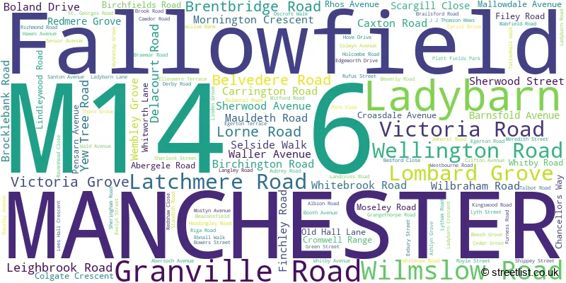
The largest settlements in the M14 6 postal code are MANCHESTER and Fallowfield.
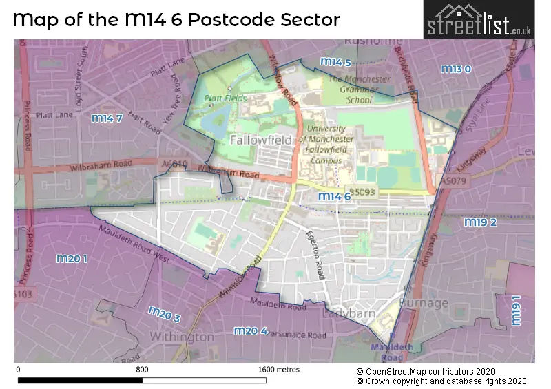
The M14 6 Postcode shares a border with M19 1 (MANCHESTER), M14 5 (MANCHESTER), M13 0 (MANCHESTER), M14 7 (MANCHESTER, Rusholme, Fallowfield), M20 1 (MANCHESTER, Withington), M19 2 (MANCHESTER, Levenshulme, Burnage), M20 3 (MANCHESTER, Withington) and M20 4 (MANCHESTER, Withington).
Map of the M14 6 Postcode Sector
Explore the M14 6 postcode sector by using our interactive map.
The sector is within the post town of MANCHESTER.
M14 6 is a postcode sector within the M14 postcode district which is within the M Manchester postcode area.
The Royal Mail delivery office for the M14 6 postal sector is the Manchester South Delivery Office.
The area of the M14 6 postcode sector is 0.92 square miles which is 2.37 square kilometres or 586.31 square acres.
Your support helps keep this site running!
If you enjoy using this website, consider buying me a coffee to help cover hosting costs.


| M | 1 | 4 | - | 6 | X | X |
| M | 1 | 4 | Space | 6 | Letter | Letter |
Official List of Streets
MANCHESTER (114 Streets)
Fallowfield (7 Streets)
(3 Streets)
Ladybarn (1 Streets)
Unofficial Streets or Alternative Spellings
MANCHESTER
BETHNALL DRIVE BRIGHTON GROVE CHERVIL CLOSE HART ROAD MOORFIELD AVENUE PARRS WOOD ROAD PARSONAGE ROAD WELD ROAD WESTRAY ROAD WHITMORE ROADWithington
MAULDETH ROADDidsbury
WILMSLOW ROAD APPLEBY LODGE EDEN COURT EGERTON MEWS ELIZABETH COURT FALLOWFIELD LOOP GUNNERY LANE JJ THOMSON MEWS ROSE COTTAGESChorlton Cum Hardy
MAULDETH ROAD WESTWeather Forecast for M14 6
Weather Forecast for Fallowfield
| Time Period | Icon | Description | Temperature | Rain Probability | Wind |
|---|---|---|---|---|---|
| 18:00 to 21:00 | Cloudy | 5.0°C (feels like 3.0°C) | 3.00% | NNW 7 mph | |
| 21:00 to 00:00 | Partly cloudy (night) | 4.0°C (feels like 1.0°C) | 1.00% | NNW 7 mph |
| Time Period | Icon | Description | Temperature | Rain Probability | Wind |
|---|---|---|---|---|---|
| 00:00 to 03:00 | Clear night | 3.0°C (feels like 0.0°C) | 1.00% | NW 7 mph | |
| 03:00 to 06:00 | Clear night | 2.0°C (feels like 0.0°C) | 1.00% | WNW 4 mph | |
| 06:00 to 09:00 | Clear night | 1.0°C (feels like -1.0°C) | 0.00% | W 4 mph | |
| 09:00 to 12:00 | Sunny day | 2.0°C (feels like 0.0°C) | 1.00% | W 4 mph | |
| 12:00 to 15:00 | Partly cloudy (day) | 6.0°C (feels like 3.0°C) | 1.00% | WNW 9 mph | |
| 15:00 to 18:00 | Sunny day | 6.0°C (feels like 3.0°C) | 1.00% | WNW 9 mph | |
| 18:00 to 21:00 | Partly cloudy (night) | 4.0°C (feels like 2.0°C) | 1.00% | WSW 4 mph | |
| 21:00 to 00:00 | Cloudy | 3.0°C (feels like 1.0°C) | 4.00% | SSW 4 mph |
| Time Period | Icon | Description | Temperature | Rain Probability | Wind |
|---|---|---|---|---|---|
| 00:00 to 03:00 | Cloudy | 3.0°C (feels like 0.0°C) | 15.00% | S 4 mph | |
| 03:00 to 06:00 | Heavy rain | 3.0°C (feels like 0.0°C) | 83.00% | S 7 mph | |
| 06:00 to 09:00 | Light rain | 4.0°C (feels like 1.0°C) | 61.00% | SSW 7 mph | |
| 09:00 to 12:00 | Cloudy | 5.0°C (feels like 2.0°C) | 13.00% | SSW 7 mph | |
| 12:00 to 15:00 | Overcast | 7.0°C (feels like 5.0°C) | 9.00% | NW 7 mph | |
| 15:00 to 18:00 | Overcast | 7.0°C (feels like 5.0°C) | 8.00% | N 7 mph | |
| 18:00 to 21:00 | Partly cloudy (night) | 5.0°C (feels like 3.0°C) | 2.00% | SW 4 mph | |
| 21:00 to 00:00 | Cloudy | 4.0°C (feels like 2.0°C) | 6.00% | E 4 mph |
| Time Period | Icon | Description | Temperature | Rain Probability | Wind |
|---|---|---|---|---|---|
| 00:00 to 03:00 | Overcast | 3.0°C (feels like 2.0°C) | 9.00% | ESE 4 mph | |
| 03:00 to 06:00 | Overcast | 3.0°C (feels like 1.0°C) | 10.00% | SE 4 mph | |
| 06:00 to 09:00 | Overcast | 3.0°C (feels like 0.0°C) | 10.00% | SE 4 mph | |
| 09:00 to 12:00 | Overcast | 3.0°C (feels like 0.0°C) | 9.00% | SE 7 mph | |
| 12:00 to 15:00 | Overcast | 6.0°C (feels like 2.0°C) | 9.00% | SSE 11 mph | |
| 15:00 to 18:00 | Overcast | 7.0°C (feels like 3.0°C) | 9.00% | SSE 11 mph | |
| 18:00 to 21:00 | Cloudy | 6.0°C (feels like 3.0°C) | 7.00% | SSE 11 mph | |
| 21:00 to 00:00 | Cloudy | 5.0°C (feels like 2.0°C) | 7.00% | SSE 11 mph |
| Time Period | Icon | Description | Temperature | Rain Probability | Wind |
|---|---|---|---|---|---|
| 00:00 to 03:00 | Cloudy | 5.0°C (feels like 1.0°C) | 10.00% | SSE 11 mph | |
| 03:00 to 06:00 | Overcast | 4.0°C (feels like 1.0°C) | 16.00% | SSE 11 mph | |
| 06:00 to 09:00 | Overcast | 4.0°C (feels like 1.0°C) | 23.00% | S 9 mph | |
| 09:00 to 12:00 | Light rain shower (day) | 4.0°C (feels like 1.0°C) | 39.00% | S 9 mph | |
| 12:00 to 15:00 | Cloudy | 6.0°C (feels like 3.0°C) | 14.00% | SSW 9 mph | |
| 15:00 to 18:00 | Overcast | 7.0°C (feels like 4.0°C) | 12.00% | SW 7 mph | |
| 18:00 to 21:00 | Cloudy | 5.0°C (feels like 3.0°C) | 8.00% | SSW 7 mph | |
| 21:00 to 00:00 | Cloudy | 4.0°C (feels like 2.0°C) | 5.00% | SSW 4 mph |
Schools and Places of Education Within the M14 6 Postcode Sector
Birchfields Primary School
Community school
Lytham Road, Manchester, , M14 6PL
Head: Mr Michael Cooke
Ofsted Rating: Good
Inspection: 2023-03-14 (687 days ago)
Website: Visit Birchfields Primary School Website
Phone: 01612243892
Number of Pupils: 664
Manchester Enterprise Academy Central
Free schools
Lytham Road, Manchester, Greater Manchester, M14 6PL
Head: Mrs Emily Reynard
Ofsted Rating: Good
Inspection: 2022-02-10 (1084 days ago)
Website: Visit Manchester Enterprise Academy Central Website
Phone: 01614992736
Number of Pupils: 1050
Mauldeth Road Primary School
Community school
Mauldeth Road, Manchester, , M14 6SG
Head: Mr A Kilcoyne
Ofsted Rating: Good
Inspection: 2023-03-22 (679 days ago)
Website: Visit Mauldeth Road Primary School Website
Phone: 01612243588
Number of Pupils: 454
St James' CofE Primary School, Birch-in-Rusholme
Voluntary aided school
Cromwell Range, Manchester, , M14 6HW
Head: Mr Gavin Shortall
Ofsted Rating: Good
Inspection: 2023-01-18 (742 days ago)
Website: Visit St James' CofE Primary School, Birch-in-Rusholme Website
Phone: 01612246173
Number of Pupils: 229

House Prices in the M14 6 Postcode Sector
| Type of Property | 2018 Average | 2018 Sales | 2017 Average | 2017 Sales | 2016 Average | 2016 Sales | 2015 Average | 2015 Sales |
|---|---|---|---|---|---|---|---|---|
| Detached | £313,750 | 4 | £323,125 | 4 | £335,000 | 6 | £278,354 | 4 |
| Semi-Detached | £250,712 | 34 | £230,208 | 52 | £200,136 | 45 | £195,014 | 37 |
| Terraced | £242,482 | 70 | £207,858 | 69 | £183,437 | 107 | £168,472 | 71 |
| Flats | £133,005 | 30 | £137,274 | 43 | £235,278 | 44 | £111,166 | 22 |
Important Postcodes M14 6 in the Postcode Sector
M14 6AA is the postcode for Royal Mail, South Delivery Office, Granville Road
M14 6BL is the postcode for Withington Girls School, 100 Wellington Road
M14 6EQ is the postcode for 2a, Wellington Road, Fallowfield
M14 6FS is the postcode for Hawthornes Medical Centre, Unit K, Fallowfield Shopping Centre
M14 6HP is the postcode for University of Manchester, Ashburne Hall, Old Hall Lane
M14 6HR is the postcode for HOLLINGS MAIN BUILDING, Manchester Metropolitan University, Hollings Faculty, Old Hall Lane, HOLLINGS LIBRARY, Manchester Metropolitan University, Hollings Faculty, Old Hall Lane, HOLLINGS CLOTHING BLOCK, Manchester Metropolitan University, Hollings Faculty, Old Hall Lane, and HOLLINGS TOASTRACK, Manchester Metropolitan University, Hollings Faculty, Old Hall Lane
M14 6HS is the postcode for Manchester High School for Girls, Grangethorpe Road
M14 6HT is the postcode for University of Manchester, Allen Hall, 281 Wilmslow Road
M14 6HW is the postcode for St. James C of E Primary School, Cromwell Range, and MAIN SCHOOL, St. James C of E Primary School, Cromwell Range
M14 6ND is the postcode for Flat 2 Ladybarn House, 2, Moseley Road
M14 6NN is the postcode for Chancellors Hotel & Conference Centre, 77 Moseley Road
M14 6PL is the postcode for Birchfields Primary School, Lytham Road, Manchester Enterprise Academy Central, 60a Lytham Road, and MAIN SCHOOL, Birchfields Primary School, Lytham Road
M14 6SG is the postcode for Mauldeth Road Primary - Kitchen & Dining Hall, Mauldeth Road, MAIN BUILDING, Mauldeth Road Primary School, Mauldeth Road, Mauldeth Road Primary - Year3&4 Block, Mauldeth Road, and Mauldeth Road Primary School, Mauldeth Road
M14 6WS is the postcode for University of Manchester, Woolton Hall, Whitworth Lane
M14 6YY is the postcode for Flat 1 Poplar Court Richmond Park, Moseley Road
| The M14 6 Sector is within these Local Authorities |
|
|---|---|
| The M14 6 Sector is within these Counties |
|
| The M14 6 Sector is within these Water Company Areas |
|
Tourist Attractions within the M14 6 Postcode Area
We found 1 visitor attractions within the M14 postcode area
| Oak House |
|---|
| Historic Properties |
| Historic House / House and Garden / Palace |
| View Oak House on Google Maps |