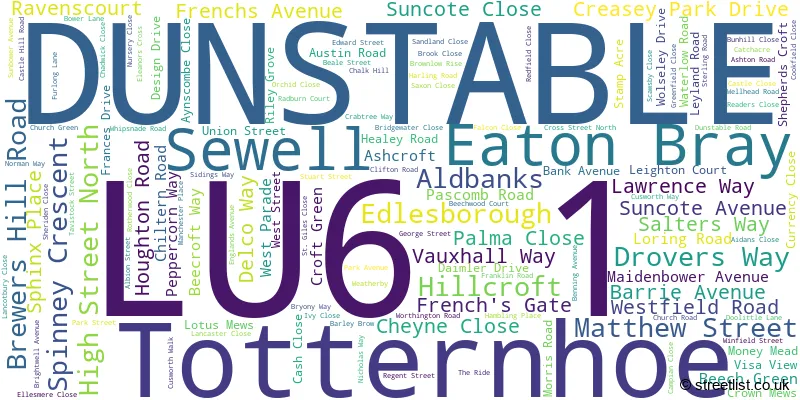
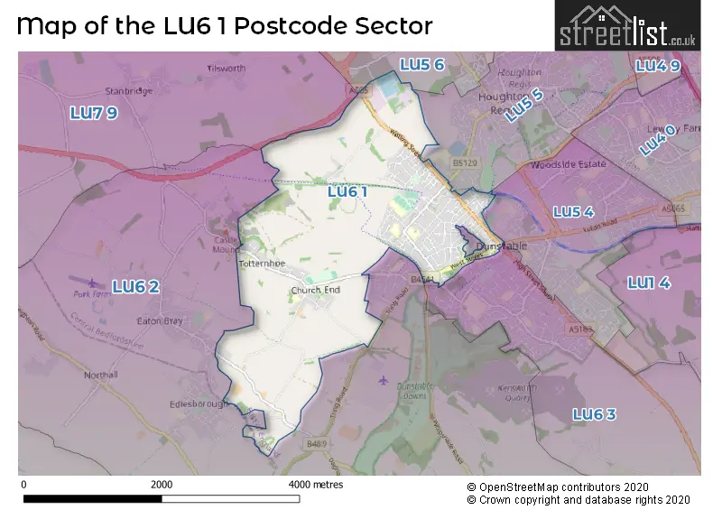
A wide range of spatial data has been analysed to present this overview of the LU6 1 Postcode sector. If you would like anything added, please contact us.
The LU6 1 postcode sector stands on the Bedfordshire and Buckinghamshire border.
Did you know? According to the 2021 Census, the LU6 1 postcode sector is home to a bustling 13,518 residents!
Given that each sector allows for 400 unique postcode combinations. Letters C, I, K, M, O and V are not allowed in the last two letters of a postcode. With 252 postcodes already in use, this leaves 148 units available.
The largest settlements in the LU6 1 postal code are DUNSTABLE and Totternhoe.
The LU6 1 Postcode shares a border with LU5 5 (Houghton Regis, DUNSTABLE), LU5 6 (Toddington, Houghton Regis, Harlington), LU6 2 (Eaton Bray, Edlesborough, DUNSTABLE), LU6 3 (DUNSTABLE, Kensworth), LU7 9 (Pitstone, LEIGHTON BUZZARD, Hockliffe) and LU5 4 (DUNSTABLE, Woodside Estate).
Map of the LU6 1 Postcode Sector
Explore the LU6 1 postcode sector by using our interactive map.
The sector is within the post town of DUNSTABLE.
LU6 1 is a postcode sector within the LU6 postcode district which is within the LU Luton postcode area.
The Royal Mail delivery office for the LU6 1 postal sector is the Dunstable Delivery Office.
The area of the LU6 1 postcode sector is 4.04 square miles which is 10.46 square kilometres or 2,585.41 square acres.
The LU6 1 postcode sector is crossed by the A5 Major A road.
Waterways within the LU6 1 postcode sector include the River Ouzel.
Your support helps keep this site running!
If you enjoy using this website, consider buying me a coffee to help cover hosting costs.


| L | U | 6 | - | 1 | X | X |
| L | U | 6 | Space | 1 | Letter | Letter |
Official List of Streets
DUNSTABLE (110 Streets)
(11 Streets)
Eaton Bray (3 Streets)
Totternhoe (16 Streets)
Unofficial Streets or Alternative Spellings
DUNSTABLE
BURR STREET CAPRON ROAD CHURCH STREET ICKNIELD STREET KIRBY ROAD MEADWAY PIPERS CROFT PRINCES STREET QUEENSWAY TRING ROAD VICTORIA STREET BOAT 1 BOAT 16 BOAT 3 BOAT 42 BREWEES HILL ROAD BW1 BW11 BW25 BW39 BW6 BW7 BW8 DOG KENNEL WALK FP 16 FP10 FP17 FP18 FP19 FP20 FP21 FP30 FP34 FP39 FP8 FP9 GREEN LANE HALF MILE HILL - BOAT 44 HOUGHTON PARADE JUBILEE COURT LUTON DUNSTABLE BUSWAY PRINTERS WAY REGEN STREET SAINT MARYS GATE SEWELL GREENWAY ST MARYS GATE STEWART CLARK COURT STIRLING ROAD THE QUADRANT TUDOR COURT WELL HEAD ROADHoughton Regis
GRENDALL LANE PORTLAND RIDEKensworth
WHIPSNADE ROADBletchley
WATLING STREETHeath and Reach
WATLING STREETWeather Forecast for LU6 1
Weather Forecast for Dunstable
| Time Period | Icon | Description | Temperature | Rain Probability | Wind |
|---|---|---|---|---|---|
| 12:00 to 15:00 | Overcast | 5.0°C (feels like 2.0°C) | 9.00% | S 9 mph | |
| 15:00 to 18:00 | Overcast | 6.0°C (feels like 3.0°C) | 9.00% | S 9 mph | |
| 18:00 to 21:00 | Overcast | 5.0°C (feels like 2.0°C) | 8.00% | S 7 mph | |
| 21:00 to 00:00 | Cloudy | 4.0°C (feels like 0.0°C) | 5.00% | SSE 9 mph |
| Time Period | Icon | Description | Temperature | Rain Probability | Wind |
|---|---|---|---|---|---|
| 00:00 to 03:00 | Partly cloudy (night) | 2.0°C (feels like -1.0°C) | 1.00% | SSE 9 mph | |
| 03:00 to 06:00 | Partly cloudy (night) | 2.0°C (feels like -2.0°C) | 1.00% | SSE 7 mph | |
| 06:00 to 09:00 | Clear night | 1.0°C (feels like -2.0°C) | 0.00% | SSE 7 mph | |
| 09:00 to 12:00 | Sunny day | 1.0°C (feels like -2.0°C) | 0.00% | SSE 7 mph | |
| 12:00 to 15:00 | Sunny day | 5.0°C (feels like 2.0°C) | 0.00% | S 9 mph | |
| 15:00 to 18:00 | Sunny day | 6.0°C (feels like 3.0°C) | 0.00% | S 7 mph | |
| 18:00 to 21:00 | Clear night | 3.0°C (feels like 1.0°C) | 1.00% | S 4 mph | |
| 21:00 to 00:00 | Clear night | 2.0°C (feels like -1.0°C) | 1.00% | S 7 mph |
| Time Period | Icon | Description | Temperature | Rain Probability | Wind |
|---|---|---|---|---|---|
| 00:00 to 03:00 | Partly cloudy (night) | 1.0°C (feels like -2.0°C) | 2.00% | SSW 7 mph | |
| 03:00 to 06:00 | Overcast | 1.0°C (feels like -2.0°C) | 9.00% | SSW 7 mph | |
| 06:00 to 09:00 | Overcast | 2.0°C (feels like -1.0°C) | 9.00% | SSW 7 mph | |
| 09:00 to 12:00 | Overcast | 3.0°C (feels like 0.0°C) | 10.00% | SSW 7 mph | |
| 12:00 to 15:00 | Cloudy | 6.0°C (feels like 3.0°C) | 5.00% | SSW 9 mph | |
| 15:00 to 18:00 | Cloudy | 7.0°C (feels like 4.0°C) | 5.00% | SSW 9 mph | |
| 18:00 to 21:00 | Cloudy | 5.0°C (feels like 2.0°C) | 5.00% | S 9 mph | |
| 21:00 to 00:00 | Cloudy | 4.0°C (feels like 1.0°C) | 6.00% | SSW 9 mph |
| Time Period | Icon | Description | Temperature | Rain Probability | Wind |
|---|---|---|---|---|---|
| 00:00 to 03:00 | Cloudy | 4.0°C (feels like 1.0°C) | 6.00% | SSW 11 mph | |
| 03:00 to 06:00 | Partly cloudy (night) | 4.0°C (feels like 1.0°C) | 4.00% | SSW 11 mph | |
| 06:00 to 09:00 | Partly cloudy (night) | 4.0°C (feels like 0.0°C) | 4.00% | SSW 11 mph | |
| 09:00 to 12:00 | Overcast | 5.0°C (feels like 2.0°C) | 10.00% | SSW 11 mph | |
| 12:00 to 15:00 | Cloudy | 8.0°C (feels like 5.0°C) | 7.00% | SSW 13 mph | |
| 15:00 to 18:00 | Overcast | 9.0°C (feels like 6.0°C) | 16.00% | SSW 13 mph | |
| 18:00 to 21:00 | Overcast | 8.0°C (feels like 5.0°C) | 22.00% | SSW 11 mph | |
| 21:00 to 00:00 | Partly cloudy (night) | 7.0°C (feels like 4.0°C) | 10.00% | SW 9 mph |
| Time Period | Icon | Description | Temperature | Rain Probability | Wind |
|---|---|---|---|---|---|
| 00:00 to 03:00 | Clear night | 5.0°C (feels like 3.0°C) | 5.00% | WSW 9 mph | |
| 03:00 to 06:00 | Clear night | 4.0°C (feels like 1.0°C) | 3.00% | W 7 mph | |
| 06:00 to 09:00 | Clear night | 2.0°C (feels like 0.0°C) | 2.00% | W 7 mph | |
| 09:00 to 12:00 | Sunny day | 3.0°C (feels like 0.0°C) | 2.00% | NW 4 mph | |
| 12:00 to 15:00 | Cloudy | 6.0°C (feels like 4.0°C) | 4.00% | NNW 4 mph | |
| 15:00 to 18:00 | Cloudy | 7.0°C (feels like 5.0°C) | 4.00% | N 4 mph | |
| 18:00 to 21:00 | Cloudy | 4.0°C (feels like 2.0°C) | 4.00% | N 4 mph | |
| 21:00 to 00:00 | Partly cloudy (night) | 2.0°C (feels like 1.0°C) | 1.00% | N 4 mph |
Schools and Places of Education Within the LU6 1 Postcode Sector
Ashton St Peter's VA C of E School
Voluntary aided school
Leighton Court, Dunstable, Bedfordshire, LU6 1EW
Head: Mr David Bower
Ofsted Rating: Good
Inspection: 2022-02-03 (1094 days ago)
Website: Visit Ashton St Peter's VA C of E School Website
Phone: 01582663410
Number of Pupils: 205
Beecroft Academy
Academy converter
Westfield Road, Dunstable, Bedfordshire, LU6 1DW
Head: Mrs Sarah Hughes
Ofsted Rating: Good
Inspection: 2023-01-30 (733 days ago)
Website: Visit Beecroft Academy Website
Phone: 01582663486
Number of Pupils: 419
Totternhoe Church of England Academy
Academy converter
Church Road, Dunstable, Bedfordshire, LU6 1RE
Head: Miss Gemma Needham
Ofsted Rating: Good
Inspection: 2022-06-15 (962 days ago)
Website: Visit Totternhoe Church of England Academy Website
Phone: 01582662959
Number of Pupils: 188
Weatherfield Academy
Academy special converter
Brewers Hill Road, Dunstable, Bedfordshire, LU6 1AF
Head: Headteacher Liam Meenan
Ofsted Rating: Good
Inspection: 2023-06-14 (598 days ago)
Website: Visit Weatherfield Academy Website
Phone: 01582605632
Number of Pupils: 165
Westfield Nursery School
Local authority nursery school
Westfield Road, Dunstable, Bedfordshire, LU6 1DL
Head: Mrs Elizabeth Collins
Ofsted Rating: Good
Inspection: 2023-10-04 (486 days ago)
Website: Visit Westfield Nursery School Website
Phone: 01582608650
Number of Pupils: 125

House Prices in the LU6 1 Postcode Sector
| Type of Property | 2018 Average | 2018 Sales | 2017 Average | 2017 Sales | 2016 Average | 2016 Sales | 2015 Average | 2015 Sales |
|---|---|---|---|---|---|---|---|---|
| Detached | £494,870 | 25 | £427,226 | 21 | £362,355 | 28 | £330,108 | 18 |
| Semi-Detached | £290,775 | 60 | £298,772 | 101 | £265,582 | 66 | £237,659 | 63 |
| Terraced | £267,928 | 98 | £266,306 | 104 | £246,961 | 126 | £222,120 | 117 |
| Flats | £192,820 | 71 | £154,487 | 78 | £158,809 | 166 | £126,902 | 76 |
Important Postcodes LU6 1 in the Postcode Sector
LU6 1AA is the postcode for Innovation Centre, 1 Brewers Hill Road, Bedfordshire & Luton Fire & Rescue Services, Fire Station, Brewers Hill Road, and Bedford College, Incuba, 1 Brewers Hill Road
LU6 1AF is the postcode for Weatherfield Academy, Brewers Hill Road
LU6 1AJ is the postcode for Brewers Hill Middle School, Aldbanks
LU6 1BB is the postcode for Creasey Park Community Football Centre, Creasey Park Drive
LU6 1DL is the postcode for Westfield Nursery School, Westfield Road
LU6 1DW is the postcode for Beecroft Academy, Westfield Road
LU6 1EW is the postcode for Ashton St. Peters VA School, Leighton Court
LU6 1JF is the postcode for East London Foundation Trust, 67 High Street North
LU6 1JH is the postcode for 59 High Street North
LU6 1LF is the postcode for Watling House, High Street North
LU6 1LP is the postcode for 4, Regent Street
LU6 1NF is the postcode for Dunstable Town Council, Grove House, 76 High Street North
LU6 1NH is the postcode for Ashton C of E Middle School, High Street North, BLOCK B, Ashton C of E Middle School, High Street North, and BLOCK C, Ashton C of E Middle School, High Street North
LU6 1RE is the postcode for Totternhoe C.E Academy, Church Road
LU6 1SF is the postcode for Doctors Surgery, 89 West Street
LU6 1SJ is the postcode for Bedfordshire Police, Dunstable Police Station, West Street
| The LU6 1 Sector is within these Local Authorities |
|
|---|---|
| The LU6 1 Sector is within these Counties |
|
| The LU6 1 Sector is within these Water Company Areas |
|