A wide range of spatial data has been analysed to present this overview of the LS25 4 Postcode sector. If you would like anything added, please contact us.
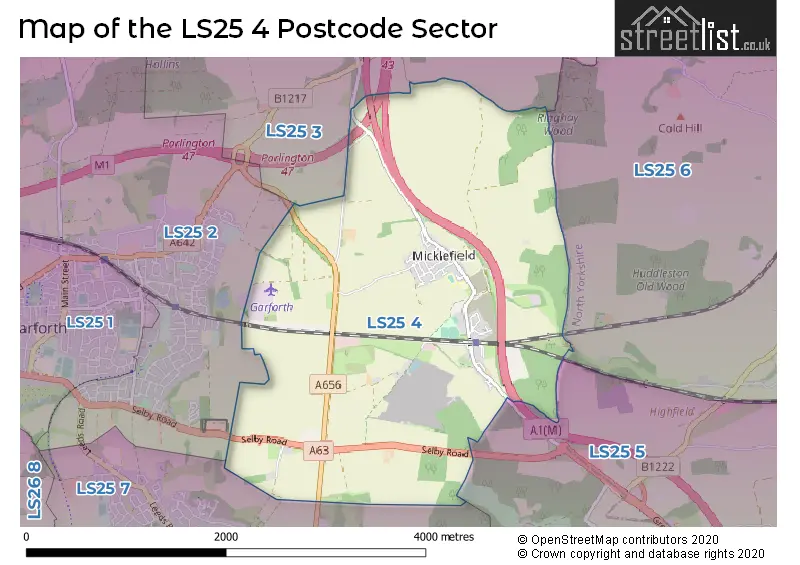
The LS25 4 postcode sector stands on the North Yorkshire and West Yorkshire border.
Did you know? According to the 2021 Census, the LS25 4 postcode sector is home to a bustling 2,107 residents!
Given that each sector allows for 400 unique postcode combinations. Letters C, I, K, M, O and V are not allowed in the last two letters of a postcode. With 74 postcodes already in use, this leaves 326 units available.
The LS25 4 postal code covers the settlement of Micklefield.
The LS25 4 Postcode shares a border with LS25 2 (Garforth), LS25 5 (South Milford, Monk Fryston, Hillam), LS25 6 (Sherburn In Elmet, South Milford, Biggin), LS25 7 (Kippax, LEEDS) and LS25 3 (Aberford).
Map of the LS25 4 Postcode Sector
Explore the LS25 4 postcode sector by using our interactive map.
The sector is within the post town of LEEDS.
LS25 4 is a postcode sector within the LS25 postcode district which is within the LS Leeds postcode area.
The Royal Mail delivery office for the LS25 4 postal sector is the Garforth Delivery Office.
The area of the LS25 4 postcode sector is 4.16 square miles which is 10.77 square kilometres or 2,661.19 square acres.
The LS25 4 postcode sector is crossed by the M1 motorway.
The LS25 4 postcode sector is crossed by the A1M Major A road.
Your support helps keep this site running!
If you enjoy using this website, consider buying me a coffee to help cover hosting costs.


| L | S | 2 | 5 | - | 4 | X | X |
| L | S | 2 | 5 | Space | 4 | Letter | Letter |
Official List of Streets
Micklefield (60 Streets)
Unofficial Streets or Alternative Spellings
Garforth
SELBY ROADKippax
RIDGE ROADAberford
GREAT NORTH ROADWeather Forecast for LS25 4
Weather Forecast for Lotherton Hall
| Time Period | Icon | Description | Temperature | Rain Probability | Wind |
|---|---|---|---|---|---|
| 03:00 to 06:00 | Overcast | 4.0°C (feels like 1.0°C) | 10.00% | S 11 mph | |
| 06:00 to 09:00 | Overcast | 3.0°C (feels like 0.0°C) | 9.00% | S 9 mph | |
| 09:00 to 12:00 | Overcast | 4.0°C (feels like 0.0°C) | 8.00% | S 9 mph | |
| 12:00 to 15:00 | Cloudy | 5.0°C (feels like 2.0°C) | 3.00% | S 11 mph | |
| 15:00 to 18:00 | Cloudy | 6.0°C (feels like 4.0°C) | 6.00% | SSW 7 mph | |
| 18:00 to 21:00 | Cloudy | 5.0°C (feels like 3.0°C) | 7.00% | S 7 mph | |
| 21:00 to 00:00 | Partly cloudy (night) | 4.0°C (feels like 2.0°C) | 1.00% | S 7 mph |
| Time Period | Icon | Description | Temperature | Rain Probability | Wind |
|---|---|---|---|---|---|
| 00:00 to 03:00 | Partly cloudy (night) | 4.0°C (feels like 2.0°C) | 2.00% | SSW 4 mph | |
| 03:00 to 06:00 | Cloudy | 4.0°C (feels like 1.0°C) | 4.00% | SSW 7 mph | |
| 06:00 to 09:00 | Cloudy | 3.0°C (feels like 0.0°C) | 4.00% | SSW 7 mph | |
| 09:00 to 12:00 | Cloudy | 3.0°C (feels like 0.0°C) | 4.00% | S 7 mph | |
| 12:00 to 15:00 | Cloudy | 7.0°C (feels like 5.0°C) | 4.00% | SSW 9 mph | |
| 15:00 to 18:00 | Cloudy | 8.0°C (feels like 6.0°C) | 4.00% | SSW 9 mph | |
| 18:00 to 21:00 | Cloudy | 6.0°C (feels like 3.0°C) | 4.00% | S 9 mph | |
| 21:00 to 00:00 | Cloudy | 6.0°C (feels like 3.0°C) | 4.00% | S 11 mph |
| Time Period | Icon | Description | Temperature | Rain Probability | Wind |
|---|---|---|---|---|---|
| 00:00 to 03:00 | Partly cloudy (night) | 6.0°C (feels like 2.0°C) | 2.00% | S 11 mph | |
| 03:00 to 06:00 | Cloudy | 6.0°C (feels like 3.0°C) | 4.00% | S 11 mph | |
| 06:00 to 09:00 | Cloudy | 6.0°C (feels like 3.0°C) | 4.00% | S 11 mph | |
| 09:00 to 12:00 | Cloudy | 7.0°C (feels like 4.0°C) | 6.00% | S 13 mph | |
| 12:00 to 15:00 | Cloudy | 9.0°C (feels like 6.0°C) | 17.00% | SSW 13 mph | |
| 15:00 to 18:00 | Light rain | 10.0°C (feels like 7.0°C) | 48.00% | SW 11 mph | |
| 18:00 to 21:00 | Cloudy | 8.0°C (feels like 5.0°C) | 12.00% | SW 9 mph | |
| 21:00 to 00:00 | Clear night | 7.0°C (feels like 4.0°C) | 5.00% | WSW 9 mph |
| Time Period | Icon | Description | Temperature | Rain Probability | Wind |
|---|---|---|---|---|---|
| 00:00 to 03:00 | Clear night | 5.0°C (feels like 2.0°C) | 2.00% | WSW 9 mph | |
| 03:00 to 06:00 | Clear night | 4.0°C (feels like 1.0°C) | 2.00% | WSW 9 mph | |
| 06:00 to 09:00 | Clear night | 3.0°C (feels like 0.0°C) | 1.00% | WSW 7 mph | |
| 09:00 to 12:00 | Sunny day | 4.0°C (feels like 1.0°C) | 1.00% | W 7 mph | |
| 12:00 to 15:00 | Sunny day | 7.0°C (feels like 5.0°C) | 1.00% | W 9 mph | |
| 15:00 to 18:00 | Sunny day | 8.0°C (feels like 6.0°C) | 1.00% | WNW 7 mph | |
| 18:00 to 21:00 | Clear night | 4.0°C (feels like 2.0°C) | 0.00% | WSW 4 mph | |
| 21:00 to 00:00 | Clear night | 2.0°C (feels like 0.0°C) | 1.00% | WSW 4 mph |
House Prices in the LS25 4 Postcode Sector
| Type of Property | 2018 Average | 2018 Sales | 2017 Average | 2017 Sales | 2016 Average | 2016 Sales | 2015 Average | 2015 Sales |
|---|---|---|---|---|---|---|---|---|
| Detached | £317,980 | 10 | £284,167 | 6 | £275,625 | 4 | £313,300 | 5 |
| Semi-Detached | £188,889 | 15 | £165,067 | 12 | £138,313 | 8 | £142,625 | 8 |
| Terraced | £131,992 | 6 | £132,264 | 21 | £146,038 | 13 | £120,512 | 24 |
| Flats | £145,000 | 1 | £102,875 | 4 | £121,500 | 1 | £95,500 | 3 |
Important Postcodes LS25 4 in the Postcode Sector
LS25 4AQ is the postcode for Micklefield Church Of England Primary School, Great North Road, Micklefield, and Micklefield C of E Primary School, Great North Road
| The LS25 4 Sector is within these Local Authorities |
|
|---|---|
| The LS25 4 Sector is within these Counties |
|
| The LS25 4 Sector is within these Water Company Areas |
|