A wide range of spatial data has been analysed to present this overview of the LS21 3 Postcode sector. If you would like anything added, please contact us.
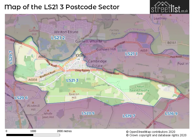
The LS21 3 postcode sector stands on the West Yorkshire and North Yorkshire border.
Did you know? According to the 2021 Census, the LS21 3 postcode sector is home to a bustling 4,710 residents!
Given that each sector allows for 400 unique postcode combinations. Letters C, I, K, M, O and V are not allowed in the last two letters of a postcode. With 158 postcodes already in use, this leaves 242 units available.
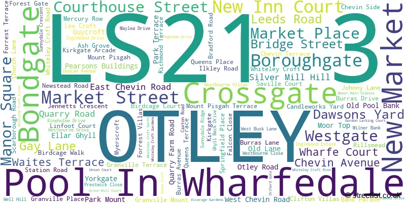
The largest settlements in the LS21 3 postal code are OTLEY and Pool In Wharfedale.
The LS21 3 Postcode shares a border with LS16 9 (Bramhope), LS21 1 (OTLEY, Pool In Wharfedale, Arthington), LS19 7 (Yeadon, Rawdon), LS20 9 (Guiseley), LS21 2 (OTLEY, Leathley, Blubberhouses), LS29 6 (Menston) and LS29 7 (Burley In Wharfedale, Burley Woodhead).
Map of the LS21 3 Postcode Sector
Explore the LS21 3 postcode sector by using our interactive map.
The sector is within the post town of OTLEY.
LS21 3 is a postcode sector within the LS21 postcode district which is within the LS Leeds postcode area.
The Royal Mail delivery office for the LS21 3 postal sector is the Otley Delivery Office.
The area of the LS21 3 postcode sector is 2.98 square miles which is 7.71 square kilometres or 1,904.64 square acres.
Waterways within the LS21 3 postcode sector include the Mickle Ing Beck, Carr Beck, River Wharfe.
Your support helps keep this site running!
If you enjoy using this website, consider buying me a coffee to help cover hosting costs.


| L | S | 2 | 1 | - | 3 | X | X |
| L | S | 2 | 1 | Space | 3 | Letter | Letter |
Official List of Streets
(19 Streets)
OTLEY (85 Streets)
Unofficial Streets or Alternative Spellings
Pool In Wharfedale
POOL BANK NEW ROAD ASHFIELD WORKS BACK LANE BAY HORSE PASSAGE CABIN ROAD CHIPPENDALE RIDE CLARO MEWS COLLEGE HILL HOUSE CROFT PLACE GROVE MILL CLOSE LINCROFT COURT MANOR COURT MICKLE ING BRIDGE MILLER LANE NEW INN YARD OCCUPATION LANE OTLEY BYPASS PIGGY LANE PIPER LANE THE DALES WAY LINK THREE HORSESHOES YARD WAITS TERRACE WHARFEBANK BUSINESS PARK WHITELY CROFT GARTHOTLEY
ALBION STREET BLOOMFIELD SQUARE CRAVEN STREET KIRKGATE ARCADE NELSON STREET NEVILLE ROAD ORCHARD GATE UNION COURTGuiseley
MALL LANE MOOR TOPBurley In Wharfedale
OTLEY ROADBramhope
HARROGATE ROAD LEEDS ROAD OLD LANEHorsforth
OTLEY OLD ROADMenston
WEST CHEVIN ROADWeather Forecast for LS21 3
Weather Forecast for Otley
| Time Period | Icon | Description | Temperature | Rain Probability | Wind |
|---|---|---|---|---|---|
| 21:00 to 00:00 | Overcast | 4.0°C (feels like 3.0°C) | 10.00% | E 2 mph |
| Time Period | Icon | Description | Temperature | Rain Probability | Wind |
|---|---|---|---|---|---|
| 00:00 to 03:00 | Overcast | 4.0°C (feels like 3.0°C) | 10.00% | S 2 mph | |
| 03:00 to 06:00 | Overcast | 4.0°C (feels like 2.0°C) | 9.00% | SSW 2 mph | |
| 06:00 to 09:00 | Overcast | 3.0°C (feels like 2.0°C) | 9.00% | SSE 2 mph | |
| 09:00 to 12:00 | Cloudy | 4.0°C (feels like 2.0°C) | 5.00% | SSE 2 mph | |
| 12:00 to 15:00 | Cloudy | 6.0°C (feels like 3.0°C) | 4.00% | S 9 mph | |
| 15:00 to 18:00 | Cloudy | 6.0°C (feels like 4.0°C) | 4.00% | S 9 mph | |
| 18:00 to 21:00 | Cloudy | 5.0°C (feels like 3.0°C) | 5.00% | S 7 mph | |
| 21:00 to 00:00 | Cloudy | 5.0°C (feels like 2.0°C) | 6.00% | SSE 7 mph |
| Time Period | Icon | Description | Temperature | Rain Probability | Wind |
|---|---|---|---|---|---|
| 00:00 to 03:00 | Overcast | 4.0°C (feels like 1.0°C) | 8.00% | SSE 9 mph | |
| 03:00 to 06:00 | Overcast | 3.0°C (feels like 0.0°C) | 9.00% | SSE 7 mph | |
| 06:00 to 09:00 | Cloudy | 3.0°C (feels like 0.0°C) | 6.00% | SSE 7 mph | |
| 09:00 to 12:00 | Cloudy | 3.0°C (feels like 0.0°C) | 7.00% | SSE 7 mph | |
| 12:00 to 15:00 | Cloudy | 6.0°C (feels like 3.0°C) | 7.00% | S 7 mph | |
| 15:00 to 18:00 | Cloudy | 7.0°C (feels like 5.0°C) | 5.00% | SSW 7 mph | |
| 18:00 to 21:00 | Cloudy | 5.0°C (feels like 3.0°C) | 4.00% | SSW 4 mph | |
| 21:00 to 00:00 | Cloudy | 4.0°C (feels like 2.0°C) | 4.00% | SSW 4 mph |
| Time Period | Icon | Description | Temperature | Rain Probability | Wind |
|---|---|---|---|---|---|
| 00:00 to 03:00 | Cloudy | 4.0°C (feels like 2.0°C) | 4.00% | SW 4 mph | |
| 03:00 to 06:00 | Cloudy | 4.0°C (feels like 2.0°C) | 4.00% | SSW 4 mph | |
| 06:00 to 09:00 | Cloudy | 3.0°C (feels like 1.0°C) | 5.00% | SSW 7 mph | |
| 09:00 to 12:00 | Cloudy | 4.0°C (feels like 2.0°C) | 5.00% | SSW 7 mph | |
| 12:00 to 15:00 | Cloudy | 7.0°C (feels like 5.0°C) | 4.00% | SSW 9 mph | |
| 15:00 to 18:00 | Cloudy | 9.0°C (feels like 6.0°C) | 5.00% | SSW 9 mph | |
| 18:00 to 21:00 | Cloudy | 7.0°C (feels like 4.0°C) | 5.00% | S 9 mph | |
| 21:00 to 00:00 | Cloudy | 7.0°C (feels like 4.0°C) | 5.00% | SSW 11 mph |
| Time Period | Icon | Description | Temperature | Rain Probability | Wind |
|---|---|---|---|---|---|
| 00:00 to 03:00 | Partly cloudy (night) | 7.0°C (feels like 4.0°C) | 8.00% | S 11 mph | |
| 03:00 to 06:00 | Cloudy | 7.0°C (feels like 4.0°C) | 17.00% | SSW 11 mph | |
| 06:00 to 09:00 | Cloudy | 7.0°C (feels like 4.0°C) | 17.00% | SSW 11 mph | |
| 09:00 to 12:00 | Cloudy | 8.0°C (feels like 5.0°C) | 18.00% | SSW 11 mph | |
| 12:00 to 15:00 | Cloudy | 9.0°C (feels like 7.0°C) | 13.00% | SSW 11 mph | |
| 15:00 to 18:00 | Cloudy | 9.0°C (feels like 7.0°C) | 12.00% | SW 11 mph | |
| 18:00 to 21:00 | Cloudy | 8.0°C (feels like 5.0°C) | 11.00% | SW 9 mph | |
| 21:00 to 00:00 | Cloudy | 7.0°C (feels like 4.0°C) | 7.00% | WSW 9 mph |
Schools and Places of Education Within the LS21 3 Postcode Sector
St Joseph's Catholic Primary School, Otley
Academy converter
Manor Square, Otley, West Yorkshire, LS21 3AP
Head: Mr Luke Gilhooly
Ofsted Rating: Good
Inspection: 2018-11-07 (2277 days ago)
Website: Visit St Joseph's Catholic Primary School, Otley Website
Phone: 01943463840
Number of Pupils: 200
Westgate Primary School
Community school
Scarborough Road, Otley, West Yorkshire, LS21 3JS
Head: Ms Helen Carpenter
Ofsted Rating: Good
Inspection: 2023-12-06 (422 days ago)
Website: Visit Westgate Primary School Website
Phone: 01943462349
Number of Pupils: 243

House Prices in the LS21 3 Postcode Sector
| Type of Property | 2018 Average | 2018 Sales | 2017 Average | 2017 Sales | 2016 Average | 2016 Sales | 2015 Average | 2015 Sales |
|---|---|---|---|---|---|---|---|---|
| Detached | £346,492 | 12 | £361,694 | 9 | £417,900 | 15 | £359,472 | 9 |
| Semi-Detached | £234,535 | 30 | £239,565 | 40 | £257,676 | 17 | £208,724 | 25 |
| Terraced | £213,483 | 31 | £212,015 | 35 | £232,749 | 27 | £184,242 | 31 |
| Flats | £184,600 | 5 | £156,831 | 18 | £160,886 | 7 | £155,350 | 4 |
Important Postcodes LS21 3 in the Postcode Sector
LS21 3AB is the postcode for West Yorkshire Fire & Rescue Service, Fire Station, Bondgate
LS21 3AP is the postcode for St. Josephs Catholic Primary School Otley, Manor Square
LS21 3AY is the postcode for St. Josephs Catholic Primary School, Manor Square
LS21 3JS is the postcode for KEY STAGE 2 BUILDING, Westgate Primary School, Scarborough Road
LS21 3LJ is the postcode for Spring Gardens Retirement Home, Westbourne Grove
LS21 3NT is the postcode for Whiteley Croft Childrens Home, 2 Whiteley Croft Garth
| The LS21 3 Sector is within these Local Authorities |
|
|---|---|
| The LS21 3 Sector is within these Counties |
|
| The LS21 3 Sector is within these Water Company Areas |
|