A wide range of spatial data has been analysed to present this overview of the LS12 4 Postcode sector. If you would like anything added, please contact us.
The LS12 4 postcode sector is within the county of West Yorkshire.
Did you know? According to the 2021 Census, the LS12 4 postcode sector is home to a bustling 9,304 residents!
Given that each sector allows for 400 unique postcode combinations. Letters C, I, K, M, O and V are not allowed in the last two letters of a postcode. With 244 postcodes already in use, this leaves 156 units available.
The largest settlements in the LS12 4 postal code are LEEDS and Lower Wortley.
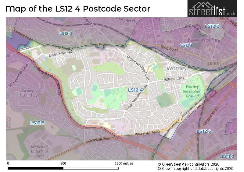
The LS12 4 Postcode shares a border with LS12 5 (LEEDS, Farnley, New Farnley), LS12 6 (LEEDS, Lower Wortley, New Farnley), LS12 1 (LEEDS, Armley) and LS12 3 (LEEDS, Armley).
Map of the LS12 4 Postcode Sector
Explore the LS12 4 postcode sector by using our interactive map.
The sector is within the post town of LEEDS.
LS12 4 is a postcode sector within the LS12 postcode district which is within the LS Leeds postcode area.
The Royal Mail delivery office for the LS12 4 postal sector is the Tong Road Delivery Office.
The area of the LS12 4 postcode sector is 0.99 square miles which is 2.56 square kilometres or 632.73 square acres.
Waterways within the LS12 4 postcode sector include the Wortley Beck.
Your support helps keep this site running!
If you enjoy using this website, consider buying me a coffee to help cover hosting costs.


| L | S | 1 | 2 | - | 4 | X | X |
| L | S | 1 | 2 | Space | 4 | Letter | Letter |
Official List of Streets
LEEDS (175 Streets)
(23 Streets)
Unofficial Streets or Alternative Spellings
LEEDS
ALBANY STREET CARR CROFTS CARR CROFTS DRIVE COPLEY HILL FARROW BANK FARROW HILL PUDSEY ROAD ROYDS LANE STONEBRIDGE AVENUE WHINCOVER DRIVE CO-OPERATION STREET GREEN GABLES GREENHILL CRESCENT OLD FIELD LANE PIPE AND NOOK LANE RING ROAD FARNLEY RING ROAD LOW WORTLEY ROYDS COURT WESTFIELD COURTFarnley
RING ROADDrighlington
WHITEHALL ROADWeather Forecast for LS12 4
Weather Forecast for Green Side
| Time Period | Icon | Description | Temperature | Rain Probability | Wind |
|---|---|---|---|---|---|
| 12:00 to 15:00 | Light rain | 10.0°C (feels like 6.0°C) | 61.00% | SW 20 mph | |
| 15:00 to 18:00 | Heavy rain | 10.0°C (feels like 6.0°C) | 85.00% | SW 20 mph | |
| 18:00 to 21:00 | Heavy rain | 10.0°C (feels like 7.0°C) | 73.00% | WSW 18 mph | |
| 21:00 to 00:00 | Cloudy | 10.0°C (feels like 6.0°C) | 26.00% | WSW 18 mph |
| Time Period | Icon | Description | Temperature | Rain Probability | Wind |
|---|---|---|---|---|---|
| 00:00 to 03:00 | Light rain | 9.0°C (feels like 5.0°C) | 58.00% | WSW 18 mph | |
| 03:00 to 06:00 | Light rain | 8.0°C (feels like 4.0°C) | 54.00% | WSW 16 mph | |
| 06:00 to 09:00 | Cloudy | 7.0°C (feels like 4.0°C) | 24.00% | WSW 11 mph | |
| 09:00 to 12:00 | Heavy rain | 6.0°C (feels like 4.0°C) | 79.00% | SSW 7 mph | |
| 12:00 to 15:00 | Heavy rain | 5.0°C (feels like 2.0°C) | 86.00% | E 9 mph | |
| 15:00 to 18:00 | Sleet | 4.0°C (feels like 0.0°C) | 65.00% | NNW 13 mph | |
| 18:00 to 21:00 | Sleet | 3.0°C (feels like -1.0°C) | 63.00% | NNW 11 mph | |
| 21:00 to 00:00 | Light rain shower (night) | 3.0°C (feels like -1.0°C) | 46.00% | NNW 11 mph |
| Time Period | Icon | Description | Temperature | Rain Probability | Wind |
|---|---|---|---|---|---|
| 00:00 to 03:00 | Partly cloudy (night) | 2.0°C (feels like -2.0°C) | 14.00% | NW 9 mph | |
| 03:00 to 06:00 | Clear night | 0.0°C (feels like -3.0°C) | 9.00% | NW 9 mph | |
| 06:00 to 09:00 | Clear night | -1.0°C (feels like -5.0°C) | 2.00% | NW 7 mph | |
| 09:00 to 12:00 | Sunny day | -2.0°C (feels like -5.0°C) | 2.00% | NW 7 mph | |
| 12:00 to 15:00 | Sunny day | 1.0°C (feels like -3.0°C) | 2.00% | NW 7 mph | |
| 15:00 to 18:00 | Sunny day | 1.0°C (feels like -2.0°C) | 1.00% | NW 7 mph | |
| 18:00 to 21:00 | Clear night | -1.0°C (feels like -4.0°C) | 1.00% | NW 7 mph | |
| 21:00 to 00:00 | Clear night | -2.0°C (feels like -5.0°C) | 1.00% | NW 7 mph |
| Time Period | Icon | Description | Temperature | Rain Probability | Wind |
|---|---|---|---|---|---|
| 00:00 to 03:00 | Clear night | -2.0°C (feels like -5.0°C) | 1.00% | WNW 4 mph | |
| 03:00 to 06:00 | Clear night | -3.0°C (feels like -6.0°C) | 1.00% | WNW 4 mph | |
| 06:00 to 09:00 | Clear night | -3.0°C (feels like -6.0°C) | 0.00% | W 7 mph | |
| 09:00 to 12:00 | Sunny day | -2.0°C (feels like -5.0°C) | 1.00% | W 7 mph | |
| 12:00 to 15:00 | Sunny day | 2.0°C (feels like -2.0°C) | 2.00% | W 9 mph | |
| 15:00 to 18:00 | Sunny day | 2.0°C (feels like -1.0°C) | 2.00% | W 9 mph | |
| 18:00 to 21:00 | Clear night | 2.0°C (feels like -2.0°C) | 2.00% | W 9 mph | |
| 21:00 to 00:00 | Clear night | 2.0°C (feels like -2.0°C) | 3.00% | W 9 mph |
Schools and Places of Education Within the LS12 4 Postcode Sector
Five Lanes Primary School
Community school
Stradbroke Way, Leeds, West Yorkshire, LS12 4NB
Head: Headteacher Joanna Mercer
Ofsted Rating: Good
Inspection: 2023-05-05 (606 days ago)
Website: Visit Five Lanes Primary School Website
Phone: 01132790122
Number of Pupils: 466
Lower Wortley Primary School
Community school
Lower Wortley Road, Leeds, West Yorkshire, LS12 4PX
Head: Mrs Jayne Geldard
Ofsted Rating: Good
Inspection: 2019-11-27 (1861 days ago)
Website: Visit Lower Wortley Primary School Website
Phone: 01133230152
Number of Pupils: 327
House Prices in the LS12 4 Postcode Sector
| Type of Property | 2018 Average | 2018 Sales | 2017 Average | 2017 Sales | 2016 Average | 2016 Sales | 2015 Average | 2015 Sales |
|---|---|---|---|---|---|---|---|---|
| Detached | £208,340 | 20 | £185,900 | 8 | £180,226 | 13 | £177,499 | 13 |
| Semi-Detached | £156,582 | 70 | £146,405 | 88 | £150,162 | 75 | £133,402 | 56 |
| Terraced | £122,643 | 91 | £121,579 | 77 | £120,968 | 107 | £103,005 | 60 |
| Flats | £80,228 | 18 | £81,765 | 13 | £72,003 | 16 | £75,893 | 14 |
Important Postcodes LS12 4 in the Postcode Sector
LS12 4JG is the postcode for Royal Mail, Tong Road Delivery Office, Upper Wortley Road
LS12 4LG is the postcode for Leeds City Council, Westholme Elderly Persons Home, Thornhill Road
LS12 4NB is the postcode for Five Lanes Primary School, Stradbroke Way
LS12 4PX is the postcode for Lower Wortley Primary School, Lower Wortley Road, and LOWER WORTLEY PRIMARY SCHOOL, LOWER WORTLEY ROAD, LOWER WORTLEY
LS12 4RB is the postcode for Wortley High School, Swallow Crescent
| The LS12 4 Sector is within these Local Authorities |
|
|---|---|
| The LS12 4 Sector is within these Counties |
|
| The LS12 4 Sector is within these Water Company Areas |
|