A wide range of spatial data has been analysed to present this overview of the LS12 2 Postcode sector. If you would like anything added, please contact us.
The LS12 2 postcode sector is within the county of West Yorkshire.
Did you know? According to the 2021 Census, the LS12 2 postcode sector is home to a bustling 8,265 residents!
Given that each sector allows for 400 unique postcode combinations. Letters C, I, K, M, O and V are not allowed in the last two letters of a postcode. With 183 postcodes already in use, this leaves 217 units available.
The largest settlements in the LS12 2 postal code are LEEDS and Armley.
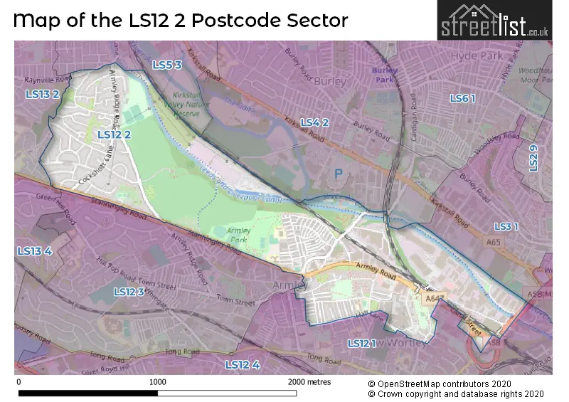
The LS12 2 Postcode shares a border with LS3 1 (LEEDS), LS5 3 (LEEDS, Kirkstall), LS13 4 (LEEDS, Bramley), LS13 2 (LEEDS, Bramley), LS1 4 (LEEDS), LS4 2 (LEEDS), LS12 1 (LEEDS, Armley) and LS12 3 (LEEDS, Armley).
Map of the LS12 2 Postcode Sector
Explore the LS12 2 postcode sector by using our interactive map.
The sector is within the post town of LEEDS.
LS12 2 is a postcode sector within the LS12 postcode district which is within the LS Leeds postcode area.
The Royal Mail delivery office for the LS12 2 postal sector is the Tong Road Delivery Office.
The area of the LS12 2 postcode sector is 0.95 square miles which is 2.45 square kilometres or 605.67 square acres.
Waterways within the LS12 2 postcode sector include the Leeds & Liverpool Canal, River Aire, Aire Valley Marina.
Your support helps keep this site running!
If you enjoy using this website, consider buying me a coffee to help cover hosting costs.

| L | S | 1 | 2 | - | 2 | X | X |
| L | S | 1 | 2 | Space | 2 | Letter | Letter |
Official List of Streets
LEEDS (125 Streets)
(20 Streets)
Armley (14 Streets)
Unofficial Streets or Alternative Spellings
Armley
BRANCH ROAD CHURCH ROADLEEDS
ARMLEY GROVE PLACE CANAL STREET CLYDE WALK EASTLAND WALK FIRST AVENUE HEDLEY CHASE HOLDFORTH GARDENS HOLDFORTH PLACE HOUGHLEY CLOSE KIRKSTALL AVENUE KIRKSTALL MOUNT MICKLEY STREET MITFORD PLACE MITFORD TERRACE MITFORD VIEW REDCOTE LANE SIMPSON GROVE STRAWBERRY LANE STRAWBERRY ROAD VIADUCT ROAD WESTERLY RISE WYTHER LANEWyther Park Industrial Estate
WYTHER DRIVEStanningley
STANNINGLEY ROADWeather Forecast for LS12 2
Weather Forecast for Armley
| Time Period | Icon | Description | Temperature | Rain Probability | Wind |
|---|---|---|---|---|---|
| 15:00 to 18:00 | Overcast | 7.0°C (feels like 6.0°C) | 9.00% | SW 7 mph | |
| 18:00 to 21:00 | Cloudy | 7.0°C (feels like 5.0°C) | 9.00% | SSW 4 mph | |
| 21:00 to 00:00 | Cloudy | 6.0°C (feels like 5.0°C) | 4.00% | S 4 mph |
| Time Period | Icon | Description | Temperature | Rain Probability | Wind |
|---|---|---|---|---|---|
| 00:00 to 03:00 | Cloudy | 6.0°C (feels like 5.0°C) | 5.00% | SW 4 mph | |
| 03:00 to 06:00 | Cloudy | 6.0°C (feels like 4.0°C) | 5.00% | SSW 7 mph | |
| 06:00 to 09:00 | Cloudy | 6.0°C (feels like 4.0°C) | 4.00% | SSW 7 mph | |
| 09:00 to 12:00 | Cloudy | 5.0°C (feels like 3.0°C) | 4.00% | SSW 7 mph | |
| 12:00 to 15:00 | Cloudy | 8.0°C (feels like 5.0°C) | 4.00% | SSW 9 mph | |
| 15:00 to 18:00 | Cloudy | 9.0°C (feels like 7.0°C) | 5.00% | SSW 9 mph | |
| 18:00 to 21:00 | Cloudy | 7.0°C (feels like 5.0°C) | 5.00% | S 7 mph | |
| 21:00 to 00:00 | Cloudy | 7.0°C (feels like 4.0°C) | 5.00% | S 9 mph |
| Time Period | Icon | Description | Temperature | Rain Probability | Wind |
|---|---|---|---|---|---|
| 00:00 to 03:00 | Cloudy | 6.0°C (feels like 4.0°C) | 5.00% | SSE 9 mph | |
| 03:00 to 06:00 | Cloudy | 7.0°C (feels like 3.0°C) | 4.00% | S 11 mph | |
| 06:00 to 09:00 | Cloudy | 7.0°C (feels like 3.0°C) | 4.00% | S 13 mph | |
| 09:00 to 12:00 | Cloudy | 8.0°C (feels like 5.0°C) | 7.00% | S 13 mph | |
| 12:00 to 15:00 | Light rain | 9.0°C (feels like 6.0°C) | 45.00% | SSW 16 mph | |
| 15:00 to 18:00 | Light rain | 10.0°C (feels like 7.0°C) | 53.00% | SSW 13 mph | |
| 18:00 to 21:00 | Light rain shower (night) | 8.0°C (feels like 6.0°C) | 33.00% | SW 11 mph | |
| 21:00 to 00:00 | Clear night | 7.0°C (feels like 4.0°C) | 4.00% | SW 11 mph |
| Time Period | Icon | Description | Temperature | Rain Probability | Wind |
|---|---|---|---|---|---|
| 00:00 to 03:00 | Clear night | 6.0°C (feels like 2.0°C) | 4.00% | WSW 11 mph | |
| 03:00 to 06:00 | Clear night | 5.0°C (feels like 2.0°C) | 1.00% | WSW 11 mph | |
| 06:00 to 09:00 | Clear night | 4.0°C (feels like 1.0°C) | 2.00% | WSW 9 mph | |
| 09:00 to 12:00 | Sunny day | 4.0°C (feels like 2.0°C) | 1.00% | WSW 9 mph | |
| 12:00 to 15:00 | Cloudy | 7.0°C (feels like 4.0°C) | 4.00% | W 11 mph | |
| 15:00 to 18:00 | Sunny day | 8.0°C (feels like 5.0°C) | 0.00% | W 9 mph | |
| 18:00 to 21:00 | Clear night | 4.0°C (feels like 2.0°C) | 1.00% | W 7 mph | |
| 21:00 to 00:00 | Clear night | 3.0°C (feels like 0.0°C) | 0.00% | W 4 mph |
| Time Period | Icon | Description | Temperature | Rain Probability | Wind |
|---|---|---|---|---|---|
| 00:00 to 03:00 | Clear night | 1.0°C (feels like -1.0°C) | 1.00% | W 4 mph | |
| 03:00 to 06:00 | Clear night | 1.0°C (feels like -1.0°C) | 0.00% | W 2 mph | |
| 06:00 to 09:00 | Clear night | 0.0°C (feels like -2.0°C) | 2.00% | NW 2 mph | |
| 09:00 to 12:00 | Sunny day | 0.0°C (feels like -1.0°C) | 3.00% | W 2 mph | |
| 12:00 to 15:00 | Sunny day | 5.0°C (feels like 4.0°C) | 1.00% | NNW 2 mph | |
| 15:00 to 18:00 | Sunny day | 7.0°C (feels like 5.0°C) | 1.00% | E 4 mph | |
| 18:00 to 21:00 | Clear night | 3.0°C (feels like 1.0°C) | 1.00% | ENE 4 mph | |
| 21:00 to 00:00 | Clear night | 1.0°C (feels like -1.0°C) | 1.00% | ENE 4 mph |
Schools and Places of Education Within the LS12 2 Postcode Sector
Holy Family Catholic Primary School
Voluntary aided school
Parliament Road, Leeds, West Yorkshire, LS12 2LH
Head: Mr Peter McQuillen Strong
Ofsted Rating: Good
Inspection: 2022-02-11 (1087 days ago)
Website: Visit Holy Family Catholic Primary School Website
Phone: 01132797572
Number of Pupils: 218
House Prices in the LS12 2 Postcode Sector
| Type of Property | 2018 Average | 2018 Sales | 2017 Average | 2017 Sales | 2016 Average | 2016 Sales | 2015 Average | 2015 Sales |
|---|---|---|---|---|---|---|---|---|
| Detached | £180,667 | 3 | £203,189 | 5 | £228,000 | 1 | £150,667 | 3 |
| Semi-Detached | £144,062 | 38 | £140,305 | 27 | £121,685 | 24 | £116,054 | 24 |
| Terraced | £109,824 | 64 | £100,129 | 69 | £127,422 | 130 | £121,871 | 117 |
| Flats | £86,170 | 10 | £86,687 | 33 | £67,833 | 3 | £87,750 | 2 |
Important Postcodes LS12 2 in the Postcode Sector
LS12 2AY is the postcode for Armley Park Primary School, Salisbury Terrace, Armley, Armley Primary School, Salisbury Terrace, Armley, and Armley Primary School, Salisbury Terrace
LS12 2DJ is the postcode for Stocks Hill Day Centre, Chapel Lane
LS12 2HE is the postcode for Parkside Lodge, 16 Stanningley Road, and Leeds & York Partnership NHS Foundation Trust, Parkside Lodge, 16 Stanningley Road
LS12 2LD is the postcode for Holy Family Catholic Primary School, Parliament Road
LS12 2LH is the postcode for Holy Family Catholic Primary School, Hall Lane
LS12 2QF is the postcode for Museum of Industry & Science, Armley Mills, Canal Road
LS12 2QX is the postcode for Gotts Park Lodge, Armley Ridge Road
LS12 2TJ is the postcode for VISITOR CENTRE, H M Prison, Armley Jail, Gloucester Terrace, VISITS HALL, H M Prison, Armley Jail, Gloucester Terrace, GATEHOUSE, H M Prison, Armley Jail, Gloucester Terrace, and H M Prison, Armley Jail, Gloucester Terrace
LS12 2UA is the postcode for Royal Mail, Leeds City Delivery Office Unit, 2 Wellington Bridge, Wellington Road Industrial Estate
| The LS12 2 Sector is within these Local Authorities |
|
|---|---|
| The LS12 2 Sector is within these Counties |
|
| The LS12 2 Sector is within these Water Company Areas |
|
Tourist Attractions within the LS12 2 Postcode Area
We found 1 visitor attractions within the LS12 postcode area
| Leeds Industrial Museum at Armley Mills |
|---|
| Museums & Art Galleries |
| Museum and / or Art Gallery |
| View Leeds Industrial Museum at Armley Mills on Google Maps |